U.S. Department of Transportation
Federal Highway Administration
1200 New Jersey Avenue, SE
Washington, DC 20590
202-366-4000
Focus
| Accelerating Infrastructure Innovations |
Publication Number: FHWA-RD-01-068
Date: October 2001
Hundreds of thousands of people visit Denali National Park in Alaska each year. Using new data collection tools, the Federal Highway Administration's (FHWA) Western Federal Lands office is testing methods to help the National Park Service (NPS) more accurately count and classify visitor's vehicles, as well as determine when it is safe to open roads to traffic in the spring. With this data, the NPS can then make better planning decisions.
In August of this year, Federal Lands conducted a pilot study in the park using a Nu-metrics NC-97 device. The counter/classifier measures the length of a magnetic field to determine a vehicle presence and its speed and length. "Measuring the length of a vehicle provides a more accurate way to classify vehicles," says Pete Field of FHWA. These measurements can help those analyzing the data to better tell the distribution between automobiles and RVs. Knowing the amount and type of vehicles helps the NPS to more appropriately size parking lots and minimize the resulting impact on the parkland.
The small, thin portable device, which is about the size of a Daytimer, can be bolted to the road. In Denali, the counters were installed on the road next to the Visitor's Center. "The portability was definitely an advantage," says Field. "They're good for studying a fixed location or doing spot studies."
A potential disadvantage is that the devices have a limited collection time. They can collect 1-week of data at 1-hour intervals and 3-4 days of data at 15-minute intervals. The data then has to be downloaded and the device recharged.
FHWA is planning a larger pilot program in the park next spring.
The Western Federal Lands staff has also started testing the use of time-domain reflectometry (TDR) in Denali. TDR has been used by the communications industry to test underground cables, by the Bureau of Mines to evaluate mine safety, and by the agricultural sector to measure soil moisture. The technology is getting a new application in Denali, however, as FHWA uses it as a ways to measure roadbed strength in the park and determine whether or not it is safe for vehicles to travel on them after the winter thaw. The data also helps the NPS to set weight limits to prevent damage to the road. TDR sensors have been installed in the ground around Denali to collect data on the moisture content of the soil. The sensors work by sending a pulse through three rods and measuring the return time and intensity of the signal. Signal loss is directly related to soil moisture content. Data will be collected this spring and winter and then a report will be issued on the trial use.
For more information on the Nu-metrics counter/classifier device, contact Pete Field at the Western Federal Lands office, 360-696-7619 (email: peter.field@fhwa.dot.gov). For more information on the use of TDR in Denali, contact Bob Beck at the Western Federal Lands office, 360-696-7824 (email: rbeck@wfl.fha.dot.gov).
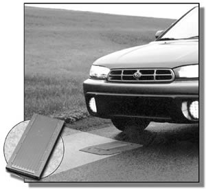 |
| The Nu-metrics device measures the length of a magnetic field to determine a vehicle presence and its length. |

