U.S. Department of Transportation
Federal Highway Administration
1200 New Jersey Avenue, SE
Washington, DC 20590
202-366-4000
FHWA Resource Center
Office of Innovation Implementation
Click here for the PDF Version of the Environmental Quarterly
Volume 5, Issue 3
SUMMER 2009
LETTER FROM THE EDITOR
Dear Environmental Colleague,
This is not the letter I intended to or wanted to write for the Summer Edition. Many of you know and are just as saddened as I am about the death of Raja Veeramachaneni, the Director of the Office of Project Development and Environmental Review in FHWA Headquarters. On a weekend day in late July we lost a champion of transportation and the environment when Raja passed away suddenly and unexpectedly. His death comes as a great shock to those of us who knew him and worked with him. It was just a few months ago in the Winter Edition, that we introduced Raja to the readers of the Environmental Quarterly. That was my first issue as Editor in Chief, and now in my third, he is gone.
I knew Raja for only a short time but I can say that it was a privilege to know him and work with him. He had a vision for the environmental discipline that some of us were just beginning to see for ourselves. He had hardly begun to make the mark he intended to and certainly would have. He is missed already.
For your reading pleasure we are happy to offer the Summer Edition of the Environmental Quarterly. I think you will find it interesting and informative.
Sincerely, Lamar Smith
Environment Technical Service Team Manager & Editor–in-Chief
Phone: (720) 963-3210
E-mail: lamar.smith@dot.gov
INSIDE
• FAQs about NEPA Reevaluations, Part 2
• Uses of GIS Data and Tools to Support Implementation of “Eco-Logical” Approaches and Inform Planning and Project Level Work and Decisions
• New DOT, HUD and EPA Partnership for Sustainable Communities
• FHWA’s Web-BA tool
• Environmental Calendar
Start of Article 1
FAQs about NEPA Reevaluations
Part 2 of a 2 Part Series
By Lamar Smith & Deborah Suciu-Smith, FHWA Resource Center
In the Spring 2009 Edition of the FHWA Environmental Quarterly (May 2009) we addressed seven commonly asked questions about the application of the FHWA regulations (23 CFR 771.129) pertaining to the FHWA reevaluation process. In part two of the series, we discuss additional questions, some of which were prompted by comments and questions received from readers of the previous article. The answers to the questions were developed and reviewed by experienced FHWA staff from the Resource Center Environment Technical Services Team and the Headquarters Office of Project Development and Environmental Review. The information provided in this series is based on existing FHWA guidance, long standing policy, experience and best practices. It is not intended to create additional requirements or provide new interpretations of the regulations. As always, the best advice we can give you is to consult with your FHWA Division Office environmental staff for assistance. We hope you find the following information useful.
WHAT DOES A REEVALUATION LOOK LIKE?
It really depends on the circumstances associated with the NEPA document being reevaluated and the purpose of the reevaluation. The documentation of a reevaluation can be as simple as a checklist, a note to the file or as comprehensive as a multi-page document complete with attachments. When the decision is made to prepare a written reevaluation or when one is required, there is no standard format that must be followed but they should be well organized and address the specifics of the project and NEPA document being reevaluated. The use of tables, charts and graphics may be useful in some situations, and reference to relevant information can simplify and enhance the documentation.
For the simplest and least environmentally intrusive projects, reevaluations should succinctly verify that the scope of project remains essentially the same, address any changes to the project and resulting impacts to natural, cultural or social resources and conclude that the NEPA document or CE determination remains valid. For more complex or controversial projects, depending on the stage of project development and the purpose of the reevaluation, additional analysis may be required to support and document a conclusion that there are no new significant impacts and that the NEPA document remains valid for the requested action or next phase of project development. In the case where the conclusion is that the NEPA document is not valid, FHWA and the applicant should immediately proceed to the appropriate next step. In any case, the scope of a reevaluation depends on the stage of project development and the purpose for the reevaluation. The documentation associated with the reevaluation should support the determination being made.
WHAT ARE THE CIRCUMSTANCES IN WHICH 23 CFR 771.130(c) WOULD APPLY INSTEAD OF 23 CFR 771.129(b) OR (c)?
23 CFR 771.130 concerns the preparation of supplemental environmental impact statements (EIS) including the circumstances when a supplemental (EIS) is and is not required. 23 CFR 130(c) specifically addresses an approach to determining the need for a supplemental EIS in situations where the significance of any new impacts are unknown. Per 23 CFR 771.130(b), an EA may be used to address project related changes or circumstances to determine if a supplemental EIS is required. The end result will either be a determination that the changes and/or any new impacts are not significant (FONSI) and that a supplemental EIS is not required, or that the changes and/or new impacts are significant and the preparation of a supplemental EIS is necessary to advance the project.
23 CFR 771.129 addresses the range of situations in which the reevaluation of a NEPA document is necessary. A written reevaluation may be an appropriate mechanism to determine if newly discovered or otherwise unaccounted for impacts related to an EIS are significant and whether or not a supplement EIS is necessary. The use of an EA for this purpose represents a more formal NEPA approach, and may be appropriate and beneficial in certain situations, such as a highly controversial projects or where additional public involvement or agency coordination is necessary. The decision regarding the approach should be based on the specific circumstances of the project, the nature and type of impacts, the need for interagency coordination and a number of other considerations. It is recommended that FHWA be consulted regarding the most appropriate course of action in these situations.
HAVE REEVALUATIONS BEEN ADDRESSED IN THE COURTS?
Yes they have. There are a few cases where FHWA reevaluations were addressed as part of NEPA litigation. In general, the courts viewed the reevaluation process as a legitimate tool for determining whether NEPA documents remain valid when it has been undertaken consistent with FHWA procedures. Some courts have validated the use of a reevaluation as an appropriate mechanism to determine if a supplemental EIS should have been prepared. Some recent cases are presented and summarized in the AASHTO March 2008 publication cited below. It is recommended that FHWA legal counsel be consulted for assistance and guidance in preparing reevaluations in situations where litigation is anticipated.
WHO IS RESPONSIBLE FOR THE REEVALUATION?
NEPA documents prepared for the FHWA are generally reevaluated by the applicant responsible for preparation of the NEPA document or CE determination. Where a written reevaluation is required, it would be prepared by the appropriate applicant on behalf of the FHWA. FHWA, however, is ultimately responsible for the reevaluation and the resulting determination.
WHAT MUST BE INCLUDED IN A WRITTEN REEVALUATION?
The essence of a written reevaluation depends on project specific circumstances and the nature of the reevaluation. With that understanding, a written reevaluation should briefly document any changes in the project, applicable laws or regulations, the project study area, and any resulting impacts (beneficial and/or adverse). Where there are few or no changes, it should be succinctly acknowledged. Any public or agency consultation, if appropriate and undertaken, should be documented and a conclusion or finding as to whether the previous NEPA document remains valid, should be plainly evident.
IF THE PROJECT SCOPE CHANGES BEFORE NEPA IS COMPLETE, IS THE PROPER DOCUMENT A REEVALUATION?
It depends on the extent of the change in the scope of the project. Keep in mind that the purpose of a reevaluation is to determine the validity of the current NEPA document to allow the project to advance; it is not an appropriate substitute for a NEPA document when one is required. If conditions have changed, a reevaluation may be appropriate to determine and document whether a supplemental EIS should be prepared or if a new NEPA document is warranted (CE, EA or EIS).
AM I REQUIRED TO CONSULT WITH REGULATORY OR RESOURCE AGENCIES OR THE PUBLIC WHEN CONDUCTING A REEVAUATION?
Again, it depends on the specific circumstances and the purpose of the reevaluation. In most cases continued consultation with the resource agencies involved or that have an interest in the study will be necessary throughout the NEPA project development process and is especially important at certain key stages. A reevaluation may or may not represent such a key stage, depending on the purpose of the reevaluation and the specifics of the project. If a reevaluation involves new or additional impacts to a resource (wetlands for example), then coordination with the responsible agency (the ACOE in this case) would certainly be appropriate and probably necessary, especially where a permit or permit modification is necessary. Resource agency input would also likely be necessary in establishing the validity of new information on a resource that they regulate or oversee, when the information has not been reviewed by them previously.
Depending on the complexity or controversial nature of the undertaking, FHWA and the applicant should consider if additional public and agency involvement is warranted. While there is no regulatory requirement for public involvement or to coordinate with other agencies, in certain cases, it is good practice and will pay dividends.
Editor’s Note:
This concludes our series on reevaluations, at least for now. We want to thank those that provided input on the questions and answers and the thoughts you shared with us associated with the reevaluation of NEPA documents. As we conclude, we want to leave you with the following summary:
1) reevaluations are required by regulation;
2) reevaluations are not NEPA documents nor are they a substitute for NEPA documentation when required;
3) the format and content of any written reevaluation or documentation of a reevaluation should reflect the circumstances specific to the project, resources and project development requirements;
4) open and timely communication between the applicant and the FHWA is critical to a solid, regulatory compliant reevaluation.
We trust you have found the questions and answers useful and recommend that you consult with your Division Office environmental staff for further clarification and assistance with any specific reevaluation issue you have. As you know, project specific guidance will vary based on the facts of the specific situation. Here’s to the successful reevaluations of your NEPA documents.
References:
23 CFR § 771.129 and § 771.130 and
FHWA Technical Advisory T6640.8A
March 2008, AASHTO, Reevaluations of NEPA Documents
End of article 1.
Start of article 2
Uses of GIS Data and Tools to Support Implementation of “Eco-Logical” Approaches and Inform Planning, Project Level Work, and Decisions as Featured at Environmental Session of 2009 Symposium, GIS for Transportation (GIS-T)
Presentation: GIS Data, Technology, and Models to Integrate Information and Improve Transportation Decision-Making within the “Eco-Logical” Framework for Oregon
Co-Authors:
Jimmy Kagan, Oregon State University, Institute for Natural Resources; Kimberly Majerus, Federal Highway Administration (FHWA) Resource Center; and Melinda Trask, Oregon Department of Transportation (ODOT)
In June of 2008, the Institute for Natural Resources at Oregon State University, working with staff from the Oregon Department of Transportation (ODOT) initiated a project to integrate complex spatial data to improve conservation planning and support transportation decision-making. The effort was selected by FHWA to receive funding to implement “Using the Eco-Logical Approach to Develop and Implement Conservation and Mitigation Priorities for Oregon” and is a complement to other efforts underway in Oregon. The approach includes advancements in the use of GIS data and technology and models.
The effort grew out of a complex set of conservation plans, priorities, and GIS datasets developed by state agencies, Federal agencies, non-profit organizations, and universities. Existing plans and data exist within a variety of scales, such as the statewide Oregon Conservation Strategy. Many plans and data sets focus on the Willamette Valley, the geographic area where most Oregonians live, and where most transportation projects occur.
An extensive amount of geospatial data is available online through the efforts of the Oregon Geospatial Enterprise Office (GEO) and its partners, including NavigatOR and the Oregon Explorer. This online geospatial data and other GIS data will be utilized. The objective is to integrate existing data to take advantage of the most up-to-date and most accurate information available resulting in a single, comprehensive data base of conservation priorities in Oregon.
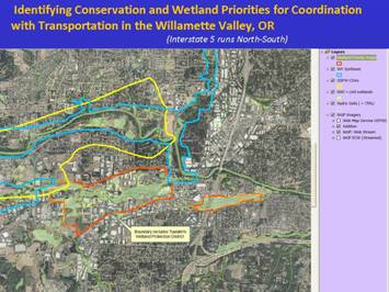
Caption: A screenshot of a Geo-Spatial GIS analysis. Geo-Spatial GIS analysis supports coordination of priorities by integrating conservation areas with “Conservation Opportunity Areas” identified in Oregon's wildlife action plan (entitled: Oregon Conservation Strategy) along with other statewide, regional, and local conservation priorities; as shown within this integrated map. (Source: Oregon Eco-Logical Project)
Geospatial data for priority wildlife habitats and species in Oregon are being updated, based on new land cover and Ecological System data and maps along with new species distribution and GIS data put together via the U.S. Geological Survey (USGS) Gap Analysis Project. A particular focus is improving information and data for the legally protected resources of wetlands and endangered species. GIS and computer models are being used to model the locations of potentially occupied wildlife habitat for state and Federally protected species. These GIS models were originally developed for use in endangered species recovery plans for Willamette Valley species in Oregon. This information is valuable for transportation decision-making in planning, project development, and project delivery.
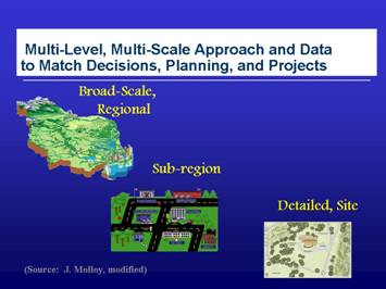
Caption. Screenshot illustrating a multi-scale, multi-level approach that shows three categories: broad-scale, regional; sub-region; and detailed, site. A multi-scale, multi-level approach supports integration of efforts and decisions across levels and scales to deliver outcomes that provide multiple benefits over the long-term.
In a US EPA and state funded effort, the state wetlands National Wetlands Inventory (NWI) database is being digitized, integrated with local wetland inventories (LWIs), wetland soil maps, and detailed wetland vegetation maps to create a comprehensive wetlands GIS spatial database. This database is being combined with conservation priorities identified within the Oregon Conservation Strategy to create a wetland priority map that will be used to coordinate with regulatory and conservation organizations. The goal is to provide an online wetland priority map and tool that would be available to support conservation and transportation decision-making and integration.
This presentation highlighted the use and updating of existing GIS data, integration of diverse data sets and spatial scales, and use of GIS geo-spatial analyses and modeling to support and strengthen conservation and transportation decision-making and integration within Oregon. Further details are available within the on-line presentation.
Source:
Excerpt from abstract submitted and accepted for presentation delivered at GIS-T 2009 Session 5.2.2
Presentation: GIS Data and Technology to Support Transportation and MPO Decision-Making and Planning using an “Eco-Logical” Approach within the Kansas City Region
Co-Authors
Tom Gerend, Tom Jacobs, Lisa Pool, and Andrea Repinsky, Mid-America Regional Council (MARC)
The Mid-America Regional Council is the metropolitan planning organization (MPO) and regional council serving the nine county bi-state Kansas City region including Missouri and Kansas. MARC submitted an application and was selected to receive FHWA funding in 2008 to implement an “Eco-Logical” approach in the Kansas City region. The approach includes research and advancements in the use of GIS data and technology and best practices to carry out the role of a regional council and MPO and transportation planning and projects.
Advancements include the use of data need assessments, incorporation of GIS data earlier in the transportation and regional planning process, and data sharing. MARC utilizes a diversity of existing GIS data available from other agencies and data sources. MARC maintains data sharing arrangements with many governmental agencies. Efforts to utilize GIS data include an extensive regional GIS-based natural resources inventory (NRI) characterizing the quality, extent, and distribution of aquatic and terrestrial natural resources with potential conservation or restoration value. Use of GIS to integrate this data with other diverse GIS data sets allows analysis and synthesis of integrated GIS maps that offer community planners and policymakers the opportunity to see where potentially high-value natural resources are located in relation to developed areas and other community assets and transportation. This information and GIS maps will be woven into regional discussions and workshops to coordinate an action plan for linking environmental and transportation planning.
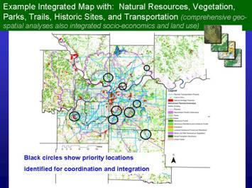
Caption: Screenshot example of GIS geo-spatial analyses results and outputs useful to support “Eco-Logical” approaches and integration for planning and project level efforts and decision-making. Source and work conducted by: MARC, Kansas City region.
GIS technology and MARC’s GIS-based NRI tool are essential components for data and integration efforts. To complete the NRI, a natural resources classification and inventory method was created to provide consistent data across the state line and among collaborating agencies. MARC began developing the NRI inventory of digital map data showing valuable natural resource assets and ecological features in the Kansas City region in 2003. The NRI initiative was funded by the USEPA and is intended to provide a framework for the local and regional levels and is expected to support transportation and MPO decision-making and planning to achieve outcomes of high quality livable environments through coordinated efforts for conservation and economic development and transportation. This presentation delivered content on GIS data sources and database compilation and best practices to include use of GIS as a technology applied to pursuing an “Eco-Logical” approach to support MPO and transportation decision-making, planning, and projects.
Further details are available within the online presentation.
Source:
Excerpt from abstract submitted and accepted for presentation delivered at GIS-T 2009 Session 5.1.2
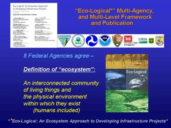
Photo of cover and signatory pages and Federal agency logos from the multi-agency “Eco-Logical” publication along with the agreed upon definition of an “ecosystem”. The “Eco-Logical” framework supports sustainable communities and economies.
“Eco-Logical: An Ecosystem Approach to Developing Infrastructure Projects”
is a multi-agency initiative and publication.
End of Article 2.
Start of Article 3.
THE WHITE HOUSE
Office of the Press Secretary
For Immediate Release September 3, 2009
NATIONAL WILDERNESS MONTH, 2009
- - - - - - -
BY THE PRESIDENT OF THE UNITED STATES OF AMERICA
A PROCLAMATION
The American wilderness has inspired wonder and imagination for centuries and is an irreplaceable part of our Nation's heritage. Even before the birth of the United States, visitors from near and far were struck by its splendor and purity. The unaltered American landscape stood apart from any other in the world. During the years of westward expansion, the wilderness frontier became synonymous with pioneer values of steadfastness and rugged independence. This month, we celebrate this history and renew our commitment to preserving the American wilderness for future generations.
Forty-five years ago, the United States achieved a landmark success in protecting these magnificent wild spaces. The Congress passed and President Lyndon B. Johnson signed the Wilderness Act, which sought to secure "for the American people of present and future generations the benefits of an enduring resource of wilderness." The Act has been widely recognized as one of our Nation's most important conservation laws. This law and the National Wilderness Preservation System it established have served as a model for wilderness protection laws in many of our States and in countries around the world.
The vision and structure established in the Wilderness Act continue to receive broad support. This pioneering law created a framework for bringing Federal public lands under additional protection. Over the past 45 years, the Congress has enacted numerous laws extending wilderness protection to vast swaths of public lands. These laws have enjoyed bipartisan support. Ranchers and anglers, small-business owners and conservationists, and Americans of diverse backgrounds have come together to preserve many of our Nation's most cherished public spaces.
My Administration has already demonstrated a commitment to protecting our wilderness heritage. On March 30, 2009, I signed the Omnibus Public Land Management Act of 2009, which established the most recent additions to our Wilderness System. As my Administration continues to prioritize wilderness protection, we will work closely with the Congress, organizations, and private citizens to ensure that all stakeholders can make their voices heard. United by a common purpose of preserving our precious natural spaces and our wilderness heritage, we will ensure that future generations inherit the unique gift of knowing nature's peace.
NOW, THEREFORE, I, BARACK OBAMA, President of the United States of America, by virtue of the authority vested in me by the Constitution and the laws of the United States, do hereby proclaim September 2009 as National Wilderness Month. I call upon all Americans to visit and enjoy our wilderness areas, learn more about our wilderness heritage, and explore what can be done to protect and preserve these precious national treasures.
IN WITNESS WHEREOF, I have hereunto set my hand this third day of September, in the year of our Lord two thousand nine, and of the Independence of the United States of America the two hundred and thirty-fourth.
BARACK OBAMA
# # #
End of article 3.
Start of Article 4.
New DOT, HUD and EPA Partnership for Sustainable Communities
The US Secretary of Transportation Ray LaHood, US Secretary of Housing and Urban Development Shaun Donovan, and US Environmental Protection Agency Administrator Lisa P. Jackson recently announced a new interagency partnership for Sustainable Communities. The partnership aims to help families across America by promoting equitable development, helping the public access affordable housing, increase transportation options, and decrease transportation costs. In addition, the partnership will work together to protect the environment and address the challenges of climate change.
Secretary LaHood said, “Creating livable communities will result in improved quality of life for all Americans and create a more efficient and more accessible transportation network that serves the needs of individual communities. Fostering the concept of livability in transportation projects and programs will help America’s neighborhoods become safer, healthier, and more vibrant.”
The Partnership for Sustainable Communities developed six livability principles that will serve as a foundation for interagency coordination:
1. Provide more transportation choices
2. Promote equitable, affordable housing
3. Enhance economic competitiveness
4. Support existing communities
5. Coordinate policies and leverage investment
6. Value communities and neighborhoods
Additional information on the partnership can be found at the FHWA Department of Public Affairs website.
End of article 4.
Start of article 5.
FHWA‘s On-line Consultation Website:
Providing Consistency and Streamlining of the ESA Section 7 Consultation
The Web-BA (esafhwa.org ) has proven to be an effective tool to expedite development, submittal, and review of BAs under the Federal Endangered Species Act and to facilitate more efficient and collaborative regulatory review and decision-making. Target users include FHWA division office, State DOT, environmental resource agencies as well as private-sector environmental practitioners.
It has been under development for 5 years in collaboration with both USFW and NOAA Fisheries. It has been successfully piloted in New York, Washington, and Texas. Pilot users indicate that, “...it is a great site and I continue to encourage our people to use it.” In addition it produces, “...a higher quality document... standardized document. This is SUCH an important utility of this package.”
Key Attributes/Aspects of Web-BA Tool
• Faster.
• More collaborative.
• Efficient information, documentation sharing.
• Solution for staff-turnover.
• Builds administrative record. • Provides centralized document repository.
• Provides standardized forms.
• Builds project-specific teams.
• Provides consistency in workflow.
• Offers accountability and status tracking.
Caption: A chart listing the key attributes/aspects of the Web-BA tool. They are listed as being faster, more collaborative, efficient information, documentation sharing, solution for staff-turnover, builds administrative record, Provides centralized document repository, provides standardized forms, builds project-specific teams, provides consistency in workflow, and offers accountability and status tracking.
A recent survey of all users of the system found:
• 95% indicated it was easy to use;
• 95% would recommend it to others;
• 87% indicated that it improved communication;
• 65% indicated that it saved time; and
• 75% rated their overall satisfaction as high or very high.
The Nationwide rollout of FHWA’s Web-BA tool occurred this summer.
End of article 5.
What's Going On?
Here are a few of the upcoming events of interest to the environmental community:
September 2009
September 13-17
Int’l Conference on Ecology & Transportation
Duluth, MN
www.icoet.net
October 2009
October 20-22
Conference on Mgmt of the Illinois River System
Peoria, IL
October 22-26
AASHTO Annual meeting
Palm Desert, CA
http://www.dot.ca.gov/aashto2009/
October 27-30
TRB’s 4th Int’l Conference on Women’s Issues in Transportation
Irvine, CA
http://onlinepubs.trb.org/onlinepubs/archive/conferences/2009/WomensIssues/Call.pdf
January 2010
January 27-30
TRB’s 89th Annual Meeting
Washington, DC
For additional conferences and events, see the FHWA Planning, Environment and Real Estate office calendar.
CONTACT INFORMATION:
Federal Highway Administration
Resource Center
Editor-in-Chief
Lamar Smith, Environment Technical Service Team Manager
Phone: (720) 963-3210/Fax: (720) 963-3041
E-mail: lamar.smith@dot.gov
Editorial Board Members:
Bethaney Bacher-Gresock, Environmental Protection Specialist
Phone: (202) 366-4196/ Fax: (202) 366-7660
E-mail: bethaney.bacher-gresock@dot.gov
Brian Smith, Biology/Water Quality Specialist
Phone: (708) 283-3553/Fax: (708) 283-3501
E-mail: brian.smith@dot.gov
Stephanie Stoermer, Environmental Program Specialist/Archeologist
Phone: (720) 963-3218/Fax: (720) 963-3232
E-mail: stephanie.stoermer@dot.gov
Deborah Suciu-Smith, Environmental Program Specialist
Phone: (717) 221-3785/Fax: (717) 221-3494
E-mail: deborah.suciu.smith@dot.gov
Managing Editor
Marie Roybal, Marketing Specialist
Phone: (720) 963-3241/Fax: (720) 963-3232
E-mail: marie.roybal@dot.gov
Production Schedule:
Due to our Quarterly publication schedule, all article submissions for future issues are due to the Editor-In-Chief by the 10th of March, June, September, and/or December
Getting the news:
*If you would like to receive this newsletter electronically, please send your email address to: bob.carl@dot.gov

