The CTIP program has funded multiple, innovative projects focused on design to help practitioners advance the industry.

Obtaining Visitor Counts Using Anonymous Cellular Phone Data, 2014
This project will deploy a visitor counting system based on anonymous cell phone data. The ability to correlate visitation patterns determined from signal data produced by cellular wireless devices is a market ready technology. The project is comparing eight months of historical cell signal counts against actual ground truth data collected within the National Parks of Arcadia, Great Smoky Mountains, and Grand Canyon, and National Forests of Hoosier (Indiana); Shawnee (Illinois), and San Bernardino (California). This ongoing extrapolation methodology comparison will develop and apply a calibration algorithm to the cell phone data so that ultimately, reliable information on visitation in Federal land units throughout the country can be measured. The U.S. Forest Service is the lead agency. ...show more about
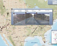
FLMA Geospatial Transportation Decision Support Tool, 2014
Federal Land Management Agency (FLMA) transportation managers maintain large, spatially dispersed, and diverse transportation networks. Data is needed at the unit, regional, and national levels make better informed and timely decisions. This project will use a map driven web application that integrates a wide variety of geospatial and traditional tabular data sets and allows users to easily search, visualize the results on a map, drill down on the underlying data, and export or print results in a user-friendly file formats. The National Park Service is the lead agency. ...show more about

Dynamic Warning Systems to Alert Motorists to the Presence of Bicyclists (Dependent on Available Funding) or (If Additional Funding Becomes Available), 2014
The goal of this project is to deploy inductive loops, an existing technology used to count or detect bicyclists, with a flashing beacon warning system to alert drivers to the presence of cyclists along shared roadways. The warning system will be triggered only when a cyclist is present, making it "dynamic". The warning system will be deployed in the Colorado National Monument and on access roads to the John Day Fossil Beds, Oregon and Gallatin National Forest, Montana. The U.S. Fish & Wildlife Service is the lead agency. ...show more about