

| Contents | Next >> |
The National Old Trails Road
Part 1: The Quest for a National Road
by
Richard F. Weingroff
Section 1 of 7
The idea of a transcontinental highway had been around since the 1890's. General Roy Stone, head of the U.S. Department of Agriculture's Office of Road Inquiry (first ancestor of the Federal Highway Administration (FHWA)), suggested combining existing roads into a network and recommended that ". . . the most effective lines that could be adopted for this purpose would be an Atlantic and a Pacific Coast line, joined by a continental highway from Washington to San Francisco." The transcontinental route should link highways along the East and West Coasts. The League of American Wheelmen Bulletin and Good Roads magazine (November 19, 1987), quoted General Stone as referring to the idea as "The Great Road of America." He knew his idea was too bold to be adopted at the time, but he explained:
The whole scheme would carry with it something that would inspire the entire Nation. It not any new scheme; it is not any new idea. It was the idea of Jefferson and Madison and Gallatin and many other great men who helped to start the national Road which led through Pennsylvania, Ohio and Indiana, and reached as far as the Mississippi River.
General Stone's successor, Martin Dodge, had endorsed the idea of a transcontinental highway shortly after taking office in 1899.
On March 4, 1902, nine auto clubs met in Chicago to combine forces in a new organization called the American Automobile Association (AAA). The new Board of Directors was instructed to begin immediate consideration of a transcontinental road from New York to California. The board chose a more northern routing than General Stone had proposed. The AAA proposal was for a macadamized road north out of New York City along the Hudson River and the shores of the Great Lakes passing through Albany and Buffalo, New York; Erie, Pennsylvania; Cleveland and Toledo, Ohio; Chicago, Illinois; Omaha, Nebraska; Denver, Colorado; Salt Lake City; Utah, and Sacramento, California.
An editorial in the May 1902 issue of Good Roads magazine considered the proposal an improvement over General Stone's idea because "it passes through many large and enterprising cities over a route a large portion of which already has improved roads and over which there will be an increasing volume of travel." Nevertheless, the editor, H. W. Perry, could not heartily endorse the plan. "The reason why a New York to Sacramento or San Francisco wagon road will not appeal to the public is because there is no need for such a road." The editor added, "The plan of a transcontinental highway is spectacular; but Congress cannot be induced to support a spectacle." Perry concluded:
Let the States and the counties be the judges of where those improved roads shall be built. They can be depended upon to act wisely in the matter, and, if the course of travel and commerce demands that the roads from city to city between New York and San Francisco need macadamizing all the way, or that the necessities require the building of expensive roads from the capital of each State to the capitals of every neighboring State before the shorter roads tributary to the shipping points are made passable, we may be sure that the long roads will receive attention.
On June 23, 1905, James W. Abbott, Special Agent (Mountain and Pacific Coast Division) for the U.S. Office of Public Road Inquiries, told the Fifth Annual National Good Roads Convention in Portland, Oregon, "We ought to have established one or more good through wagon roads from the Atlantic to San Francisco, and to the Northwest." He cited the proposal by Martin Dodge at a Good Roads Convention in Denver 5 years earlier:
[Dodge] delivered a memorable address, of which the controlling thought was this great need for such highways. A short time before that a wild and visionary article had appeared in one of the magazines, advocating a boulevard 200 feet wide from ocean to ocean, with its separate divisions for vehicles, bicycles, pedestrians, trees, grass, flowers, and I don't know what else. Senator Dodge's address was practical and timely.
In August 1906, Good Roads magazine published an article about a proposal to build an "American Appian Way." This "latest proposition in this land of big schemes" was routed from " Washington, on Atlantic tidewater, following the trail of the historic National Pike through the passes of the Appalachians and across the Ohio, through the great middle west to St. Louis, and then into two great boulevards on to the Pacific, one of which will cross Montana to Puget Sound and the other through Denver and Salt Lake over the Rockies and Sierras to San Francisco." The article describing the proposal stated:
Automobile associations and good roads folks all over the country are pledged to the support of the bill. "Honk! Honk!" is the war cry of the new movement.
Early advocates of good roads, while advocating long distance roads, soon adopted the idea of naming highways and forming associations to support the route. In early 1902, the Jefferson Memorial Road Association began promoting construction of a memorial road from Thomas Jefferson's home at Monticello to the University of Virginia in Charlottesville, the university he founded. The New York-Chicago Road Association formed on June 17, 1902, to advocate an improved public road between the two cities of its name. The July 1902 issue of Good Roads explained that ". . . the plan is to connect the present good roads along the route with new ones to be built by the states, counties and municipalities along the line."
By the 1910s, local organizations, chambers of commerce, towns, and good roads advocates throughout the country began to select old roads for improvement and to give them names as a rallying point. One of the earliest was the National Old Trails Road, which was an outgrowth of two movements in Missouri. The first was the drive for a cross-State highway from St. Louis to Kansas City. The second was an effort by the State chapter of the Daughters of the American Revolution (D. A. R.) to mark the historic Santa Fe Trail, the old trader's route to New Mexico.
The Missouri Cross-State Highway
In the summer of 1907, Governor Joseph W. Folk of Missouri expressed an interest in a cross-State macadam highway. The Highway Department of the State Board of Agriculture identified three feasible routes. The northern route passed through St. Charles, Louisiana, Bowling Green, Mexico, Moberly, and Liberty. The central route passed through Columbia, crossing the Missouri River at Arrow Rock on the way to Kansas City. It incorporated Boon's Lick Road and part of the Santa Fe Trail. The southern route approximates modern U.S. 50.
The State Board and Governor Folk met on August 5, 1907, to designate the cross-State highway. Instead of choosing one, though, they designated all three routes. While this decision encouraged local initiative by keeping competition alive, it did not result in construction of a cross-State highway. The "idea slumbered," according to the State Board's September 1911 bulletin, until 1911:
Various newspapers gave space in helping keep alive the movement. The Kansas City Star and Kansas City Post especially are to be commended for the stand taken and for being consistent "boosters" for a cross - state highway. During this time the lovers of history and admirers of romance joined in the fight. This was on account of the historic route, over which Daniel Boone and pioneers of the West blazed their way and around which linger many pleasing tales of pioneer times, being one of the practical routes for a state highway. This brought the Santa Fe Trail and Boone's Lick Road Association, the Kansas City Historical Society, the Missouri Historical Society, and the Daughters of the American Revolution into the fight. The work of the latter was directed, however, more towards the placing of markers along the historical trail.
By 1911, the idea of a transcontinental highway was receiving increasing attention. The Fourth International Good Roads Congress, meeting in Chicago, endorsed a transcontinental route from New York City through Chicago to Kansas City, thence over the historic Santa Fe Trail to Santa Fe, New Mexico, and continuing to Phoenix and Los Angeles. Dozens of good roads bills were introduced in the 62nd Congress (1911-12). Some involved a specific road proposal, such as S. 6271, which would have authorized construction of a national highway from the Canadian border south of Winnipeg to Galveston, Texas, or the bill that would have authorized $10,000 to build a road through the Medicine Bow Forest Reserve in Colorado.
Among the more ambitious bills was one introduced by Senator Shelby Moore Cullom of Illinois on August 11, 1911, to create a National Interstate Highways and Good Roads Commission to build seven named national highways radiating from Washington. The plan included a road from Washington to Seattle, Washington (Lincoln National Interstate Highway) and two roads to California (Jefferson National Interstate Highway to northern California and the Grant National Interstate Highway to southern California) as well as shorter routes to Portland, Maine (Washington); Niagara Falls, New York (Roosevelt); Austin, Texas (Monroe); and Miami, Florida (Lee). (One critic, Representative Michael E. Driscoll of New York, dismissed the flood of good roads bills, complaining that all of them came from "the great broad states in the South and West of large areas, long roads, small populations, and small taxing power."
With interest growing, several States decided to take it upon themselves to identify the best route within their borders for a transcontinental highway. These State efforts grew out of the belief that, someday, such a road would be built. Designation of the route in advance, they thought, would give the State control over the location.
In 1911, therefore, Governor Herbert S. Hadley revived the idea of a single cross-State highway from among the three chosen in 1907. Communities along the three lines understood the importance of the decision:
It meant that if the route was selected and put through, that not only would portions of the state be visited by many people and that this would be a link in the some-time Ocean to Ocean Route, but it meant the stimulation of a sentiment for good roads in Missouri that in the course of a few more years would bring about a great upheaval in this state which would mean the building of highways that would connect with this route.
During July 1911, a delegation headed by Governor Hadley inspected the three routes. Communities outdid each other in welcoming the inspectors, in the hope of securing the designation:
It is impossible to bring in all of the roads lined with bunting, the gate posts decorated with flags, garlands of flowers and farm produce; the crowds of people gathered at the country schoolhouses that had not been open since the closing of the sessions, of the barrels almost bursting with ice-cold lemonade; the tables "groaning" with fried chicken, Missouri ham, cake and ice cream, and dainties known only to Missouri housewives. As one member of the party expressed the trip, they "literally ate their way through fried chicken and ham."
On August 11, 1911, 1,600 delegates filled the Jefferson Theatre in Jefferson City for a meeting on the issue. Each of the three routes was defended in speeches. Dean Walter Williams of the School of Journalism, University of Missouri, spoke on behalf of the Central Route:
I have no word of criticism of any other route that may be proposed. But as for me and mine . . . we are for the Boon's Lick Road and the Santa Fe Trail. May I add that we are not polygamists either. We do not want to tie up the affections of Missouri to three Cross-State Highways . . . . We want no cut-offs in ours. I am for the Boon's Lick Road and Santa Fe Trail, the Old Trails Route . . . .
A few days later, State Highway Engineer Curtis Hill submitted a summary of the three alternatives to the State Board. One factor that Hill cited in favor of the central route was his view that the Old Trails Route had already been selected as part of a transcontinental highway:
The trans-continental route which would cross Missouri is the proposed extension from Washington to San Francisco of the Old Cumberland Turnpike and the route is termed the Ocean to Ocean Highway. The Old Cumberland Turnpike was originally surveyed to St. Louis, which is the logical place for it, and either of our proposed cross-state roads would be available. This Ocean to Ocean Highway, however, is now routed by the U.S. Office of Public Roads over the Old Boon's Lick Road or our Central Route.
This was a misstatement. The Office of Public Roads (another of the FHWA's early names) had not routed the transcontinental highway. Shortly before Hill prepared his report, the Office had published a map of nearly 15,000 miles of transcontinental, interstate, and trunk line roads contemplated around the country. Reporting on the map, Better Roads magazine (August 1911) pointed out that if the plans were fulfilled, they would result in "a network covering the whole country." The routes depicted on the map were:
Capital-to-Capital Highway (Washington, D.C., to Jacksonville, Florida)
Central Highway in North Carolina
Clay-Jefferson Memorial (Niagara Falls, New York, to Meridian, Mississippi)
Des Moines-Kansas City-St. Joseph Trail
Dupont Highway in Delaware
Lincoln Memorial Road (Washington, D.C., to Gettysburg, Pennsylvania)
Lincoln Way (Louisville to Nashville, Kentucky)
Memphis-to-Bristol Highway
Montreal-to-Miami Highway
Ocean-to-Ocean Highway
Pacific Highway
Rio-to-Rio Highway (Denison to Galveston, Texas)
Yellowstone to Glacier National Park
The route Hill had in mind was the Ocean-to-Ocean Highway, described as:
Ocean to Ocean Highway, extending from Cumberland, Md., to Tacoma, Wash., and passing over the old Cumberland Road, through Columbus, Indianapolis, St. Louis, over Boone's Lick Trail and St. Louis to Old Franklin, Mo.; through Nebraska, Wyoming, Idaho, Oregon, and Washington. 3,800 miles.
The Office did not endorse the route. As Better Roads explained, the Office had published the map ". . . merely for the purpose of gauging the extent of the good roads movement as fostered by individuals, associations, and communities."
After Hill's report had been adopted, the members of the State Board designated the central route as "The Missouri Cross State Highway--Old Trails Road." The cross-State route was dedicated on October 28, 1911. Dedication parties left St. Louis and Kansas City, to meet in Columbia for the ceremony. Governor Hadley delivered the dedicatory address, in which he said:
This marks the beginning of the end of bad roads in Missouri. The people who are building this road are as truly pioneers as those hardy frontiersmen who blazed the Old Trails Route into the forests and over broad prairies . . . . With great pleasure in the present occasion, and with hopes for the future, I now dedicate the Old Trails Route the Missouri Cross State Highway, to the men and women of Missouri of the present and the future.
The Woman's Old Trails Road
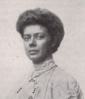 Miss Elizabeth Gentry Click on image for larger version |
In 1911, Miss Elizabeth Butler Gentry of the D.A.R. copyrighted a publication titled:
The Old Trails Road,
The National Highway.
A Memorial to the Pioneer Men and Women.
A Suggestion of the Missouri Good Roads Committee
Daughters of the American Revolution.
Miss Gentry, Jackson County's Chairman of the Missouri Good Roads Committee, described the proposed project:
The historic old trails, comprising this project, are: the old National or Cumberland Road, which includes the Braddock's or Washington Road; the Boon's Lick Road; Santa Fe Trail; Kearny's Road; Oregon Trail.
She explained the origins of the movement:
The Missouri Good Roads Committee had planned a woman's national movement to awaken interest in a national highway from ocean to ocean, along the old trails of the nation's pioneers . . . . T he Kansas City Chapter, Santa Fe Trail Committee [of the D. A. R], first suggested to and urged upon the Governor and State Highway Engineer of Missouri that the old trails of the State should be reblazed into modern roads as a monument to the pioneers of the State. Due to five years of untiring efforts, this committee is acknowledged by the State Board of Agriculture as the vital force that carried this project to its culmination and dedication as the Missouri State Highway--the Old Trails Road--on Oct. 28th, 1911.
The Missouri Good Roads Committee, appointed by the State Regent, was the result of this achievement. The dream of this committee is to make the Missouri highway, but a link in a national highway--to extend the Old Trails eastward over the Old National Road to Washington; westward over the old Santa Fe Trail and Kearny's Road to San Francisco; north-westward over the Oregon Trail to Olympia . . . . The women of the seventeen Trail States will be vitally interested and the women of other states will see the value to human welfare of a national good road, which will serve to unify and bind together the D. A. R. interests of the country.
As the Missouri Good Roads Committee has originated this movement . . . it will act as a central and directing committee for the national work . . . . A prominent D. A. R. in each state will be invited to be chairman of this work in her state . . . . A meeting of this committee is hereby called in the Missouri Room, Continental Memorial Hall, Washington, D.C., second day of D. A. R. Congress, 1912, at 3 o'clock
Miss Gentry's publication listed members of an Advisory Committee to the Missouri Good Roads Committee. Judge J. M. Lowe of Kansas City was the Chairman (in Missouri, a "Judge" was the equivalent of a County Executive, not a judge of law). Members included:
- Professor Williams;
- Logan Waller Page, Director of the Office of Public Roads;
- Col. Wm. F. "Buffalo Bill" Cody of North Platte, Nebraska;
- Ezra Meeker, who had traveled to Oregon in a covered wagon in 1852, and duplicated the trip in reverse to publicize the historic trail in 1906;
- The Governors of Ohio, Illinois, Missouri, Kansas, Colorado, New Mexico, and Wyoming;
- U.S. Representatives Champ Clark and William P. Borland (MO.).
The pamphlet estimated the cost of the project:
The cost per mile of highway is variously estimated, owing to prairie or mountain country, proximity to road materials, etc., at from $4,000 to $10,000 a mile. As there are about 5000 miles of road in this project, it calls for an expenditure of fifty million dollars.
The goal was to have Congress designate the route for Federal construction:
A bill has been prepared at the request of the Missouri Committee and will be introduced in Congress sometime during December, 1911, by Congressman Wm. P. Borland, of Kansas City, Mo.
Each state committee should instruct its members to write their senators and representatives at Washington, asking them to vote for the Historic Trails Bill of the D. A. R. To carry this women's measure, it should be emphasized, that the interest is non-political, non-commercial; purely historic, patriotic, entirely practicable and of national value . . . .
The D. A. R. of each trail state should insist that the trail be adopted as their state highway. Fifty road bills are before Congress. It will take a strong and united effort by the D. A. R. to win out.
The map in the pamphlet showed the contemplated road. The Oregon Trail branched off the Santa Fe Trail in Gardner, Kansas, just as the original trails had separated. At Fort Hall, the California Trail to San Francisco split from the Oregon Trail, again as had the historic trail. The Old Trails Road also followed the Santa Fe Trail and its Cimarron Cut-Off, the short-cut through a territory with less access to water and more danger from Native Americans than on the main line.
The two routes connected south of Raton, New Mexico, then continued through Santa Fe, Albuquerque, and Gallup. In Arizona, the road passed through Holbrook and Flagstaff before turning southwest to Prescott and south to Phoenix. From Phoenix, it moved west again to Yuma and San Diego. The trail ran up the West Coast to link with the California Trail in San Francisco. The map identified the route through the Southwest as "Kearneys Route Santa Fe to Monterey & link to San Francisco."
General Stephen Watts Kearny was in charge of the Army of the West during the Mexican War in 1846. He was ordered to take over California and set up a temporary civil government. After following the Santa Fe Trail from Missouri, Kearny easily captured Santa Fe; Governor Manuel Armijo surrendered without a shot being fired. On September 24, 1846, the Army of the West set off to complete the defeat of the Mexican forces in California.
Miss Gentry's map was inaccurate in depicting the route followed. Kearny did not follow a route through Gallup, Flagstaff, and Prescott. He moved south from Santa Fe along the Rio Grande River on the ancient Spanish trail known as El Camino Real (The King's Highway). In Socorro, New Mexico, he met his friend Lieutenant Christopher "Kit" Carson, who was returning from California with the news-somewhat premature, as it turned out-that California had been conquered by the combined forces of Captain Robert F. Stockton and Lieutenant John C. Fremont. After reducing the size of his force to little more than an escort, Kearny convinced Lieutenant Carson (who had been ordered to take dispatches to Washington) to take the small expedition to California over a route Carson had not only helped open but had just traveled.
From Soccoro, Carson led the force west to the Gila River and followed it to the Pima Villages near where the city of Phoenix would be established in the 1860's. Still generally following the Gila River, they continued to the future site of Yuma at the Colorado River. After fording the river, Kearny led his men across the southern California desert amid considerable hardship. On the plain of San Pascual near present day Escondido, Mexican soldiers under Don Mariana Flores attacked the small American force. Kearny, although wounded in the fighting, held out for 4 days before being rescued by troops from San Diego. Kearny finally reached San Diego on December 12. (Kearny and forces from San Diego defeated Governor Pio Pico at the Battle of San Gabriel on January 8-9, 1847. Hostilities ended a few days later. The Mexican government surrendered control of California to the United States by approving the Treaty of Guadalupe Hidalgo on February 2, 1848.)
Miss Gentry's pamphlet concluded with a section headed "D.A. R. Motor Trip to Panama Exposition in 1915":
Mr. and Mrs. Thos W. Wilby, of New York and Washington, have just finished a motor round-trip of these trails-10,000 miles-to lay out and log the road for the Government. They praised the scenic beauty and historic value of these trails, their practicability and charm for motor travel.
The fascination of the road is known to all travelers, whether it be by camel, stage coach or motor car, and the call of the road to its lovers is as insistent a note as the call of the sea to the sailor or the call of the desert to the Arab.
What more delightful than a D.A.R. automobile pilgrimage over the Old Trails Road to the Panama Exposition in San Francisco in 1915? Visits could be made to historic places enroute and at famous old taverns, reviving the life of the old trails. To achieve success in this mutually beneficial project it will mean several years of splendid cooperative work. The dream of Missouri women will come true, through the help of women of other states in preserving the old trails and the historic spirit of the nation.
Wilby was a Special Agent of the Office of Public Roads. The Office designated unpaid travelers as "Special Agents" to examine roads, take photographs of them, and report on conditions, type of construction, and economic facts. The Office, in some cases, provided photographic equipment.
As Special Agent, Wilby described his mission as laying out and charting two transcontinental roads, as well as conducting an inspection tour. Wilby and his wife Agnes traveled in a touring car manufactured by the OhiO Motor Car Company and driven by Fred D. Clark. (Transcontinental tourists during this period often employed drivers.) The car was nicknamed the "Mud Hen" based on its successful experience in the Munsey Tour of 1910. Clark was a well-known driver who had completed a heavily publicized 4,767-mile trip that began in New York City on November 22, 1910, and ended in San Francisco, via a southern route, on January 14, 1911. "No automobilist," publicist Guy Finney of the OhiO Motor Company wrote, "completing an extended journey need now hold back for fear of 'the unknown.'"
The Wilbys began their trip in New York and went by way of Chicago, Illinois; Des Moines, Iowa; Omaha, Nebraska; Cheyenne, Wyoming; Ogden, Utah; Reno, Nevada; and Sacramento, to San Francisco. The route was designated the "Pioneer Highway," an informal name applied to the route by auto clubs. They toured south to San Diego, then headed west via Phoenix and Santa Fe to La Junta, Colorado; then to Hutchinson and Emporia, Kansas; Columbia and St. Louis, Missouri; Indianapolis, Indiana; Wheeling, West Virginia; Cumberland, Maryland; Washington, D.C.; and Baltimore, Maryland, to New York via Philadelphia and Atlantic City. The Wilbys' southern route was "The Old Trails Highway." Neither route was supported by the Office of Public Roads, which was not promoting such projects .
According to the January 1912 issue of Touring Topics magazine, this trip was the first time a woman had made a double transcontinental tour by automobile. Mrs. Wilby told the writer that the 105-day trip had been delightful, with the beauties of the country affording ample compensation for the "few slight discomforts" of the trip. Mr. Wilby was especially encouraged by the enthusiasm he encountered for good roads:
Few motorists in the east have any idea not only of the enthusiasm, but of the general hard and effective work being done in the western and southwestern states for good roads. At every point I found much enthusiasm for highway improvement, the state officials and highway authorities assuring me that appropriations, running in to the millions, would soon be available for the surveying and building of trunk lines through their commonwealths.
After returning to New York, Wilby took the time on January 20, 1912, to write to Missouri's Curtis Hill. Wilby reported that he had completed his trip in 105 days, during which he laid out and charted two feasible transcontinental routes. He was concerned that wherever he went, the interest in good roads was "purely local," when he believed, "The Trascontinental Highways are of First importance." Moreover, time was being wasted waiting for Federal-aid:
Let organized effort still be directed towards inducing Congress to vote money for National Highways, but let it not be forgotten that the people have already taken the initial steps in this work . . . . Any scheme for State Highways which do not form a direct link in the Transcontinental chain must be secondary. Time enough for those others when the Great Transcontinental Highways, forming the longest and most wonderful sightseeing thoroughfares known, shall be an accomplished feat.
The Old Trails Road, which he called "American History crystallized," seemed to him an ideal transcontinental road:
Who with the red blood of national pride within him does not thrill at the thought of such roads as these! They are surely highways worthy of the American people.
An article in the December 1911 issue of Southern Good Roads described "The Woman's National Old Trail Roads Association":
A movement initiated by Miss Elizabeth Butler and other women of the Missouri Daughters of the American Revolution has resulted in the formation of the Woman's National Old Trail Roads Association, the first national good roads association to be composed exclusively of women . . . . It is planned to make the proposed national highway a project in which every woman in the United States will be interested.
The national highway will start at Washington, D.C., [and follow the old trails to Santa Fe]. There will be two routes to San Francisco. One, the Southern, over Kearney road, through Phoenix, Ariz., and Monterey, Cal., the other, the Northern route, will lead from Gardner, Kansas., to Fort Hall, Ida., and finally to San Francisco. A third route may be established from Fort Hall to Olympia, Washington, over the old Oregon trail, made famous of late by Ezra Meeker of Portland, whose ox team drive over it was a picturesque event in 1906.