

U.S. Route 80 The Dixie Overland Highway
by
Richard F. Weingroff
Federal Highway Administration
U.S. 80 Map | Dixie Overland Highway Map
A look at a road atlas from the early 1920's would reveal a complete network of named trails crisscrossing the country. The Lincoln Highway, from New York City to San Francisco, was the best known road of its day. Other well-known routes included the:
Dixie Highway (Sault Ste. Marie, Michigan, to Miami, Florida),
Meridian Highway (Winnipeg, Canada, to Laredo, Texas),
National Old Trails Road (Baltimore, Maryland, to Los Angeles, California)
National Park to Park Highway (a circle route linking western National Parks),
Victory Highway (New York City to San Francisco), and
Yellowstone Trail (Boston, Massachusetts, to Seattle, Washington).
The 250 or so named trails, although they carried picturesque and memorable names, became a confusing jumble. At the request of the State highway agencies, the Secretary of Agriculture appointed the Joint Board on Interstate Highways in April 1925 (the U.S. Bureau of Public Roads (BPR) was in his Department). The Joint Board, which included 21 State highway officials and three BPR officials, met with State road officials around the country, developed standardized signs, including the original U.S. shield, identified the Nation's main interstate roads, and conceived a system for numbering them.
The Joint Board completed its report on the new marking system in October 1925. Within the proposed grid of U.S. routes, the report identified U.S. 80. The original description of the route (spelling as in original) read:
From Savannah, Georgia, to Swainsboro, Macon, Talbotton, Columbus, Montgomery, Alabama, Selma, Meridian, Mississippi, Jackson, Vicksburg, Tallulah, Louisiana, Monroe, Shreveport, Marshall, Texas, Dallas, Fort Worth, Eastland, Sweetwater, Pecos, Van Horn, El Paso, Las Cruces, New Mexico, Lordsburg, Rodea, Douglas, Arizona, Tucson, Florence, Phoenix, Gila Bend, Yuma, Holtville, California, El Centro, Jacumba, San Diego.
The Secretary of Agriculture submitted the Joint Board's proposal to the American Association of State Highway Officials (AASHO) for consideration. His action reflected the fact that the roads were owned and operated by the States, not the Federal Government, and the States, therefore, would have to decide whether to adopt the proposal. Over the next year, AASHO acted on requests, many initiated by named trail associations, to change the routes and numbers.
Finally, in November 1926, AASHO adopted the U.S. numbered plan. The first official description of the approved U.S. 80 appeared in the U.S. numbered log that AASHO printed in April 1927:
United States Highway No. 80.
Total Mileage, 2,726
Georgia Beginning at Savannah via Swainsboro, Dublin, Jeffersonville, Macon, Knoxville, Talbottom to the Georgia-Alabama State line at Columbus.
Alabama Beginning at the Georgia-Alabama State line at Columbus via Tuskegee, Montgomery, Selma, Demopolis, Livingston to the Alabama-Mississippi State line west of Cuba.
Mississippi Beginning at the Alabama-Mississippi State line west of Cuba via Kewanee, Meridian, Newton, Forest, Jackson, Vicksburg to the Mississippi-Louisiana State line at Delta.
Louisiana Beginning at the Mississippi-Louisiana State line at Delta via Tallulah, Royville, Monroe, Ruston, Arcadia, Minden, Shreveport to the Louisiana-Texas State line east of Waskom.
Texas Beginning at the Louisiana-Texas State line east of Waskom via Marshall, Longview, Mineola, Dallas, Fort Worth, Eastland, Abilene, Big Spring, Pecos, San Martine, Van Horn, El Paso to the Texas-New Mexico State line south of Anthony.
New Mexico Beginning at the Texas-New Mexico State line south of Anthony via Los Cruces, Deming, Lordsburg to the New Mexico-Arizona State line west of Rodeo.
Arizona Beginning at the New Mexico-Arizona State line west of Rodeo via Douglas, Bisbee, Tombstone, Benson, Tucson, Florence, Mesa, Phoenix, Buckeye, Gila Bend, Sentinel, Yuma to the Arizona-California State line at Yuma.
California Beginning at the Arizona-California State line west of Yuma via El Centro, Jacumba to San Diego.
A Series of Changes
By the time of the next log, published in 1929, AASHO had approved an eastern extension of 8 miles, making Tybee Island the starting point of U.S. 80. Today, Tybee Island remains the eastern terminus.
Beginning in 1927, the BPR issued press releases describing some of the major U.S. numbered highways. One November 1927 release ("United States Routes Make Cross-Continent Run Easy") stated:
Two . . . United States routes have a special interest for prospective transcontinental travelers living in the large eastern cities; one - Route 40 - because it is the most direct motor route to California, and the other - a combination of Routes 40, 61, 70, 67, and 80 - because it is a year-round road and, for the present at least, is more surfaced throughout than any other transcontinental highway.
The release speculated that the motorist would reach U.S. 80 in Dallas:
From Dallas, the ascent to the mountains is so gradual as to escape casual observation until the first summit of the Rocky Mountain Range is reached about three miles east of Allamore, Texas, elevation 4,640 feet above sea level. From this point the route drops down to an elevation of 3,700 feet of El Paso, Texas, in the valley of the Rio Grande River, then rising and falling, between four and five thousand feet above sea level, practically to Lowell, Arizona, the road reaches the summit of the Continental Divide about three miles west of Bisbee, Arizona, at the Mule Pass - altitude 6,035 feet - and then descends rapidly, over two lesser divides, to Yuma, Arizona, on the Colorado River and less than 200 feet above sea level. From Yuma to El Centro the road is practically level, and then, between El Centro and San Diego, climbs over the summit of the coast range - elevation 4,103 feet above sea level. The traveler should be careful to turn to the right at Newtown - 52 miles west of El Centro - in order to keep on Route 80.
The release added a comment about conditions motorists would face after crossing the Continental Divide:
Because of the southern latitude and the comparatively low altitudes, the route is never blocked by snow and is open to automobile travel the year round; but where it crosses the Southwestern deserts it has the disadvantage of being uncomfortably hot in the summer months.
Around this time, the BPR issued a separate release on U.S. 80 summarizing the condition of the road:
Route 80 has a total length of 2,671 miles, of which 798, or about 30 percent, are paved with brick, concrete or bituminous macadam, according to figures of the Bureau of Public Roads of the United States Department of Agriculture. More than half the mileage, or 1,472 miles, is surfaced with gravel, sand-clay or topsoil. Climatic conditions in the Southern States are favorable for this lighter construction, which is proving adequate for present traffic. Some of the States have developed very successful methods of treating sand-clay and lime rock roads to eliminate dust which is the one important defect of such surfaces in this region. On the route there are 315 miles of graded and drained earth roads, and 86 miles of unimproved highways.
In the improvement of Route 80, the States have been helped materially by the Federal Government. Of the total mileage, 1,502 miles have been improved with Federal aid, at a total cost of $23,372,305 of which the Government contributed $11,041,351, or about 50 per cent [the standard Federal share of Federal-aid project costs at the time].
A New Ending
In the years since then, U.S. 80 has shifted somewhat to place it on improved alignments and city or town bypasses. More important, U.S. 80 has been shortened, and no longer serves as a transcontinental highway. The shortening began in California. Under State Senate Bill 64, California renumbered its State highway system, effective July 1, 1964. The State law provided that each route should have a single number, with precedence given to retention of present sign route numbers in the following order: Interstate routes, U.S. numbered routes, and State sign routes. To comply with this requirement, California asked AASHO to remove the State's section of U.S. 80 from the official log. The changed was first reflected in AASHO's U.S. route log published in 1969.
On October 28, 1977, the Route Numbering Committee of the American Association of State Highway and Transportation Officials (AASHTO-the name adopted in 1974) approved Arizona's request to eliminate the section of U.S. 80 between the California State line and Benson, Arizona. New Mexico requested elimination of its segment in 1989, with Arizona joining in to request elimination of the short section remaining in that State. On October 6, 1989, AASHTO's Special Committee on U.S. Route Numbering approved the request to eliminate U.S. 80 from the intersection with I-10 in Benson, Arizona, to the intersection with State Route 48 in Anthony, New Mexico. The official length of U.S. 80 was 1,706 miles.
In 1991, New Mexico and Texas joined in asking AASHTO to eliminate the U.S. 80 designation between Anthony and the intersection with I-30 in Dallas. In an August 28 news release ("What's in a Name?"), the Texas State Department of Highways and Public Transportation explained the decision:
A highway that crosses 21 counties and shares most of its route with three Interstates will lose its designation as a U.S. highway . . . . The highway will be dedesignated [as] a state highway where its route is now concurrent with Interstates 10, I-20 and I-30 . . . . Redesignating US 80 is part of AASHTO's nationwide program to redesignate roadways identified by more than one route number. The program is intended to lessen drivers' confusion and to cut the cost of duplicate signs and maintenance.
The request was approved on October 12, 1991. Dallas remains the western terminus of U.S. 80.
Dixie Overland Highway
In numbering the roads in 1925, the Joint Board on Interstate Highways had avoided giving a single number to the longer named trails. The members feared that a single number would allow the named trail promotional groups to continue their activities, to the detriment of the motoring public. However, out of necessity, long segments of the named trails were often given a single number-they were the best routes available for interstate motorists.
In the case of U.S. 80, much of the route was formerly known as the Dixie Overland Highway. From Savannah to Sweetwater, Texas, U.S. 80 was virtually identical to the Dixie Overland Highway routing. At El Paso, U.S. 80 rejoined the Dixie Overland Highway and stayed with it to San Diego. ("Overland" was spelled variously with and without a dash: Dixie Over-land Highway and the Dixie Overland Highway. This account has dispensed with the dash.)
The Automobile Club of Savannah conceived the Dixie Overland Highway in July 1914. The March 1917 issue of Better Roads and Streets carried an association press release that summarized the history of the organization:
Columbus, Georgia, February 26, 1917. And in the beginning Oglethorpe made a trail, DeSoto ended his in the Mississippi, Balboa started the habit of gazing on the Pacific. Later, Sherman made a trail to the East and certain ambitious southerners made another, paved with dreams of a new empire. Since then no railroad, wagon road, or other highway has been attempted through the southern States for the purpose of connecting the Atlantic with the Pacific, until two years ago in the month of July.
In July, 1914, the Automobile Club of Savannah, Georgia, made a path-finding tour across the State of Georgia to Columbus. They found a practical route, one-half of which was constructed road. A meeting was held in Columbus. It was determined to secure the construction of the entire highway.
The cross Georgia highway again revived the thought suggested by the pioneers, and an ocean to ocean highway was projected. An association was formed, officers elected, and a plan of operation agreed upon. The object of the association being to promote the construction and use of a highway through the States of Georgia, Alabama, Mississippi, Louisiana, Texas, New Mexico, Arizona, and California.
As a result of the investigation to determine the location of the highway, a practical route was found, connecting the cities of Savannah, Columbus, Montgomery, Selma, Meridian, Jackson, Vicksburg, Shreveport, Dallas, Fort Worth, Alamogordo, El Paso, Lordsburg, Douglas, Phoenix, Yuma, San Diego, and Los Angeles, which will never be snowbound, and hence, provide an all-year road.
It was then developed that the Dixie Overland Highway when constructed will be the shortest, straightest, and only year round, ocean to ocean highway, in the United States. All highways east of the Mississippi and the most of those west of the river, are laid out for north and south travel. The Dixie Overland connects them all, is a trunk line through the heart of the "black belt,"[1] crossing the rivers at the head of navigation, and forming what the promoters believe to be the most useful and important highway in the South.
It is valuable for the transportation of passengers in business and pleasure cars. It will be used in the next step in the evolution of transportation for the exchange of light, and short distance freight. Its location and advantages will make it of particular value for military purposes.
The officers of the association early announced that it was a fraud to advocate a highway until it was one. So no literature or maps were printed and circulated; instead the road building authorities in each of the seventy-five counties through which the highway passes, have been asked to enter into an agreement with the association to build and maintain a practical year round automobile highway for the Dixie Overland. As a result, all of the highway is now constructed in Georgia. Recent investigations indicate that the construction of practically all of the remainder of the highway to the Pacific, will be completed during the coming summer.
If the construction is completed, it is the expectation of the officers of the association to formally open the highway in October, with an ocean to ocean tour, from Savannah to Los Angeles . . . .
The trail of Oglethorpe has been projected to the object of Balboa's scrutiny. The spirit of DeSoto may now continue its westward march, not hampered by unbridged streams, or trackless forests, or burning deserts, join those who gaze on the placid Pacific, and if weary grown, return over 3,000 miles of sun-kissed, historic lands to native habitat by the Father of Waters, or pass beyond to the storm-tossed sea of the Rising Sun.
The first meeting of the Dixie Overland Highway Association was held in Columbus on July 17, 1914, to celebrate the arrival of the pathfinders from Savannah. As association was organized "to ascertain the practicability of promoting an all-weather highway through the South." The following year, on July 24, the association met in Savannah for its second meeting. It received reports that "an ocean-to-ocean all-weather highway was practical and was then about 50 percent construction." With that assurance, the members formed a permanent organization.
On February 14, 1917, the Dixie Overland Highway Association was incorporated in the State of Georgia for a 20-year period as a nonprofit organization, with headquarters in Columbus:
Its purposes are to foster the construction and use of a highway from Savannah, Georgia, to Los Angeles, California, through eight states, seventy-four counties and nearly two hundred towns and villages; to strive for uniform, wise and equitable road legislation in the States of Georgia, Alabama, Mississippi, Louisiana, Texas, New Mexico, Arizona and California; to aid in bringing about efficient road administration; to seek continuous and systematic maintenance of all roads and their classification according to traffic requirements; to promote cooperation in "units" or "locals" on the parts of towns, cities, communities, precincts and other political subdivisions; to mark the highway; to give publicity to its historical character, by monuments, guide-books, bulletins and other printed matter; to affiliate and cooperate with other good roads associations.
The association's motto was: "The Shortest and Only Year Round Ocean-to-Ocean Highway."
In August 1918, the Dixie Overland Highway Association met in Shreveport, Louisiana, for its fifth annual convention. The question of the western terminus-Los Angeles or San Diego-was a key issue. A report in the September 1918 issue of the association's newsletter explained that the convention opened on that note:
There was a dramatic opening to the Convention when the presiding officer, Dr. S. M. Johnson [Vice President, New Mexico], called the six foot delegates from San Diego and Savannah to the platform and suggested that they shake hands as a pledge of the terminal cities to see the highway constructed.
The issue was of sufficient importance for the Governor of California to get involved:
Governor Stephens, of California, sent as his personal representative Stanley Hufflund, of San Diego. Mr. Hufflund also represented the San Diego Chamber of Commerce, and the California Vice-President. On behalf of San Diego he asked that the highway be terminated at that city instead of Los Angeles. The matter was recommended favorably to the Executive Committee.
The issue also contained a letter from Colonel Ed Fletcher, a San Diego developer and booster who was active in several named trail associations. He was unable to attend the convention, but wanted to let the participants know why he believed the route should end in San Diego:
It is fitting that San Diego should be the western terminus. It is now a city of one hundred and fifteen thousand inhabitants, with a perfectly land-locked bay and twenty-two miles of ocean dockage in the most southwesterly harbor of the United States.
In May 1919, the Executive Committee of the Dixie Overland Highway Association approved San Diego as the western terminus, and elected Colonel Fletcher to be President of the association. In a statement, Fletcher commented:
I certainly appreciate the honor of having been elected president of the Dixie Overland Highway Association and will give the best that there is in me to continue the good work. I let it be known to the executive committee when the offer was tendered that I could not give all my time to it and that I would not consider taking up the work unless San Diego was made the Pacific terminus.
Colonel Fletcher and the Western End
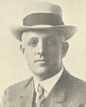 |
Colonel Ed Fletcher began his San Diego career as a produce merchant, but soon branched out into water and land development. He and other San Diego boosters recognized that one of the chief obstacles to its development was Los Angeles. Early in the century, Los Angeles, unlike San Diego, had a direct rail link to the east. San Diego's efforts to secure a rail line were frustrated by financial problems and the difficulty of terrain. Interest, therefore, turned to roads, as described in Richard F. Pourade's Gold in the Sun: The History of San Diego (The Union-Tribune Publishing Company, 1965):
The first step in establishing a favorable auto road to Imperial Valley was taken with the improvement of the road eastward through the mountains to Jacumba and Boulder Creek but stopping short of the descent down what is known as Mountain Springs into the desert.
Los Angeles, watching San Diego's road-building activity toward Imperial Valley which threatened to put direct routes into southern Arizona and open the door to transcontinental auto travel and trade, hastened work on a route to the valley by way of San Bernardino and Mecca. With the arising of competition from Los Angeles, San Diegans again sought contributions from concerned citizens and raised $60,000 to extend the new road from the San Diego County line to the desert floor in Imperial County.
The difficulties of the San Diego route are illustrated by an anecdote included in Albert D. Manchester's Trails Begin Where Rails End (Trans-Anglo Books, 1987). He described a 1910 trip by Harold Collyer (20 years old) and Bud Price (about the same age) in a Ford Model T. A portion of the trip, as narrated by Manchester, follows the route of future U.S. 80 in the Southwest:
The boys left home [a farm in west Texas] with five gallons of gasoline, five gallons of water, and couple of gallons of oil tied to the running boards. They carried enough tools to open up a repair garage anyplace along the way. Shovel, axe, and camping gear were tied on. Spare tires and desert bags (drinking water) were attached wherever else they could find room. Full of bacon and biscuits, they chattered [sic] away from home on a cool morning.
It was still quite hot when they pulled into Deming, New Mexico, late that night, out of water, almost out of gasoline, and tired right down to the bone marrow from shoveling sand. The day had taught them one thing about desert travel: get an early start, even before the sun comes up; get down the road a ways before the day heats up. Relax in the middle of the day, if you have to. Travel again in the evening. Summertime in the Southwest is an unhealthy time of the year to be shoveling sand under the midday sun. They bought tarps to throw under the tires, for traction over soft sand.
Two or three days later they showed up in Tucson, where they had to replace a tire; sand and heat were already hard at work on the Ford. They drove through Gila and Yuma, places that have their own brand of summer heat . . . . When they had to repair tires along the road, they tied the tarp to the car, staked the other end of the tarp to the ground, and worked in the shade . . . .
After they crossed the Colorado River into California, they ran into deep sand. The Ford ground away through the sand, gulping water for relief. At last they came to the famous wooden road that had been put down over the dunes. The road was just wide enough for one car, but wider places had been built into the road every mile or so in order to let one car pass another. Harold and Bud didn't meet anybody.
When they fueled up in El Centro, they learned that the road over the hills to San Diego was so rough and steep that their T might not make it. Gasoline was fed to the T carb by gravity; going uphill, gas just might not feed to the carb properly if the road happened to be too steep. Some drivers solved the problem by backing uphill, but when you were climbing a steep, narrow, winding mountain road that climbed for several miles, such a tactic could prove impractical. Harold and Bud solved that problem by stationing Bud out on a fender with a can of gasoline. He poured gas into the carburetor at just the right intervals to keep the car going. It was a risky business because Bud was in danger of falling off the car--it was a rough road--or accidentally pouring gasoline all over the engine and possibly starting a fire that would destroy their car.
They pulled out on top at Jacumba, 4,000 feet above sea level and fifteen degrees cooler. It felt so good up there they decided to camp under a big tree while they worked on the car, cleaning it and greasing it, and going over it with their tools to tighten anything that had vibrated loose. This was a common chore with the early drivers. The cars vibrated a good bit all by themselves, but after bouncing all over bad roads for a week or so, they could be in need of tender attention with wrenches and screwdriver.
After camping in San Diego, Harold and Bud drove to Los Angeles before turning east. They took a northern route into Arizona, but eventually picked up future U.S. 80 in New Mexico.
The rest of the trip was comparatively uneventful. Just steady driving through sand and dust and mud, fixing a flat now and then for a break in the routine. They drove through Lordsburg, Deming, Las Cruces, El Paso. And home. All the tires were worn out. The car had about five hundred new rattles. (It should be remembered that a lot of wood was used in car bodies before the 1930s, and especially in the arid Southwest, the bodies would loosen up.) But they just cleaned the car, ground the valves, tightened her up . . . and she was about as good as a T could ever get.
Pourade described some of the construction work underway in 1911:
The highest elevation on the lowest pass of the mountain mass on the direct Yuma-San Diego route was about 4000 feet. Just east of Jacumba the elevation was about 3200. For several years road crews had been hacking out a new highway down the mountains from Jacumba. The old wagon road, which had been used by autos for a decade, left Jacumba Valley and went northeast and then almost directly south to reach Mountain Springs, dropping about a thousand feet in three miles; then it followed the bed of Devil's Canyon, a virtual tunnel between towering red rock hills and dropping another thousand feet to the upper desert floor. Any auto caught in this narrow gap in a desert cloudburst could be picked up by rushing water and battered to pieces against the walls.
The new road was following what eventually became Highway 80, clinging precariously to the sides of precipitous mountains, dipping in and out of their scalloped sides and reaching Mountain Springs from the south, a drop of a thousand feet. Avoiding Devil's Canyon, it was turning down Myer Canyon, or In-Ko-Pah Gorge, for another thousand feet, again clinging to a narrow ledge cut out of the mountain sides, and was to reach the desert floor near Ocotillo . . . .
The Mountain Springs road was dedicated during spring 1913 ceremonies. Pourade, who reported that 800 excursionists attended the ceremonies, quoted a speech by J. J. Carr, Chairman of the Imperial County Board of Supervisors:
Imperial County is growing by leaps and bounds. This stretch of road is just what it needs. I fail to find words to express the gratification of Imperial Valley residents. Products of the valley will be hauled to San Diego for market. Your coffers will in a few years team with the valley wealth.
In the self-published 1952 book Memoirs of Ed Fletcher, Colonel Fletcher described the celebration as a gala occasion:
Hundreds of machines took the first ride down the canyon to the desert, returning via Devil's Canyon to Mountain Springs. My friend, William Allen White, of Emporia, Kansas, was our guest of honor that day and wrote a splendid tribute.
The tribute, which was written 2 decades later, was called "A Crystallized Hope." Fletcher liked it enough to reprint it:
Newspapers in the southwest corner of America tell of another remarkable achievement--the completion of a national highway between San Diego and Phoenix with only 20 miles unpaved between El Paso and San Diego. Twenty years ago this thing was projected as a dream of a super-realtor in San Diego, Ed Fletcher, and in the mind and heart of Governor Hunt, of Arizona. When the thing was started the projectors had to go by rail by way of Los Angeles in order to get to Yuma.
Governor Hunt is still governor; Ed Fletcher is still dreaming big dreams in San Diego that crystallize into reality. It's a lot of fun to be that kind of man. It brings more happiness to see how things can happen and get fooled sometimes when they don't happen rather than to see how things can't happen and then get fooled when they do.
In December 1911, 84 delegates from Arizona, California, and New Mexico met in Phoenix to form the Ocean-to-Ocean Transcontinental Highway Association. The goal was to select a route and promote construction of a highway across the country. A delegate from Los Angeles, John S. Mitchell, was elected President, but San Diego was represented by A. G. Spalding, the sporting goods manufacturer, and Rufus Choate of the Chamber of Commerce. According to Pourade:
The Arizona and New Mexico delegates had no trouble agreeing on a route through their states but the Californians were divided on whether it should go directly from Yuma to Los Angeles, by way of the Salton Sea and San Bernardino, or by way of San Diego. San Diego lost, and the decision also removed the principal towns of Imperial Valley, El Centro, Holtville and Calexico, from the proposed national road system . . . . The route by way of San Diego had ninety miles less of desert though it was about thirty miles farther than by way of the Salton Sea [to Los Angeles] and the mountain barrier made it slow and much more difficult.
In April 1912, one of the organizers of the Ocean-to-Ocean Highway Association, Colonel Dell M. Potter of Clifton, Arizona, attended the first National Old Trails Road Convention in Kansas City, Missouri. Organizers intended to designate a transcontinental route following some of the Nation's most historic roads, including the National Road in the East and the Santa Fe Trail. Colonel Potter addressed the convention to recommend adoption of the Ocean-to-Ocean Highway as the western link of the new trail. Participants agreed to affiliate with the association, and even adopted part of its name (the National Old Trails Road Ocean-to-Ocean Highway Association). However, the western segment along the Ocean-to-Ocean line was listed on association maps as "tentative."
In February 1913, Colonel Potter helped organize the Southern National Highway Association. As explained in the March 1913 issue of Southern Good Roads, a convention was held on February 12 in Asheville, North Carolina, ". . . for the purpose of deciding upon a route to be recommended to congress as a practicable line to connect with the San Diego-El Paso road, far enough south to permit of all-the-year travel between the Atlantic and Pacific Coasts . . . ." Colonel Fletcher was a State organizer for California.
When the National Old Trails Road Ocean-to-Ocean Highway Association held its second annual convention on April 29-30, 1913, members agreed on a western alignment across northern Arizona into Los Angeles (by the road that became U.S. 66), bypassing Colonel Potter's route. "Ocean-to-Ocean" was dropped from the association's name. Although the timing may have been coincidental, these actions may have resulted from the fact that Colonel Potter's Southern National Highway would be a direct competitor of the National Old Trails Road and also bypassed Missouri, the home base of the leaders of the organization.
In the long run, the National Old Trails Road was one of the best known of the named trails, and its association one of the most prominent. Although Colonel Potter promoted the Southern National Highway into the 1920's, it had little impact on motorists of the day and was gradually replaced by other named trails.
Meanwhile, Colonel Fletcher continued promoting a transcontinental route for San Diego. In 1912, he joined with other prominent San Diegans who raised $3,000 as prize money and challenged Los Angeles interests to a race to Phoenix. Residents of Phoenix added $1,000 in prize money. The competition began with a pathfinder race. Colonel Fletcher drove San Diego's entry, a Franklin provided by the Tribune-Gazette, from San Diego by way of El Centro, a distance of 360 miles. He arrived in Phoenix after a trip of 19 hours. The Los Angeles entry traveled by way of Blythe, a distance of about 425--or would have if the car hadn't broken down in the desert. The vehicle never reached Phoenix.
When the official race took place, 22 vehicles left San Diego, but only 12 reached Phoenix. The lead vehicle, driven by San Diego auto dealer D. W. Campbell, was 2 hours ahead of the first vehicle from Los Angeles. "However," as Pourade explained, "though the route from Los Angeles was sixty-five miles longer, in actual running time from the starting city to destination, the Los Angeles auto beat Campbell's time by fourteen minutes."
The race had been part of a series of endurance races that began in 1908, when the Automobile Club of Southern California conceived the idea as a way of promoting the good roads cause. The races came to be known as the "Desert Race" or the "Cactus Derby." Some years, participants drove from Los Angeles directly to Phoenix; other years, they went through San Diego. In 1913, a similar race took place from El Paso to Phoenix, timed to coincide with the Cactus Derby. Some of the participants, upon arriving in Phoenix, organized the Borderland Route Association to promote construction of a road from Galveston, Texas, to Los Angeles via San Diego--essentially the route that became U.S. 80.
One of the chief obstacles to this or any other road through southern California was the segment across the sand dunes in Imperial County. Ben Blow described the problem in his 1920 book, California Highways (H.S. Crocker Co., Inc.):
From San Diego, where connection is had with the coast route to Los Angeles and San Francisco, to El Centro, no particular engineering difficulties prevailed, rerouting of existing roads to secure a minimum grade being necessary in some places but the work mainly being straight road-building with no particular frills . . . . To the east of El Centro, however, or more properly speaking, from Holtville, was a situation that the most stout-hearted engineer gazed at with something which approached affright. Huge dunes made up of what is expressively designated blow-sand piled up in ever-changing formation in the Colorado Desert, where a torrid sun, lack of water, and almost unconquerable sand made travel a thing to be approached almost with prayer. All existing roads, in the old days, were merely wagon or automobile tracks in the sand, tracks that were filled up almost as soon as made . . . .
The January/February 1987 issue of Going Places described one early attempt to solve the problem:
The dunes, the surviving beaches of prehistoric Lake Cahuilla, have changed very little in the 140 years since John Fremont's Continental Telegraph Survey of 1848. Stretching 30 miles from north to south and seven miles east to west, the dunes were a formidable barrier to travel until highway engineering ingenuity overcame nature.
In 1902 someone discovered that laying a patch of Arrow Weed, a stiff weedy type of native vegetation, across the dunes would allow horse-drawn and horseless carriages to drive over. But the brush would break down and wheels would bog down in the sand.
These difficulties were among the reasons transcontinental routes bypassed San Diego. To solve this problem, Colonel Fletcher went to work:
I could see the importance of building a highway directly through the sandhills, if possible, to say nothing of saving the cost of building and maintaining that additional 46 miles, also, the added benefit of shortening the national highway 46 miles, all to San Diego . . . . [During a California Highway Commission meeting selecting routes, I asked that they] take no action on the proposed routes to Phoenix until I could demonstrate the feasibility of putting a highway through the sand hills, in which case, I would guarantee to raise the necessary funds to make the demonstration by putting a wooden plank road through the sand hills. The highway commission granted my request and I immediately went to El Centro to help raise funds and get the support of Imperial County, financially and otherwise, in making demonstration . . . .
I made an arrangement with Supervisor Ed Boyd whereby I would raise the funds to buy 37 carloads of plank and pay the freight to Glamis, the nearest railroad siding to the sand hills, and Ed Boyd, out of the road funds from his district and with the assistance of neighbors and friends would haul the lumber and lay the plank road ready for travel . . . . I raised $13,000.00 in San Diego, something like $3,000.00 in Yuma, and enough funds altogether from other sources . . . .
The total cost was $20,000, which funded construction of a 6-mile plank road across the sand dunes. The plank road was constructed in about 3 weeks, beginning on February 13, 1915. Pourade called it ". . . a flimsy, two-track road of . . . two-by-twelve planks nailed to cross ties which provided two tracks each twenty-five inches wide." He added, "It required a steady hand at the wheel to keep an auto on the tracks in the face of adverse weather and terrain."
Blow described the unusual road:
. . . on these boards many an automobile made the trip, now and then falling upon evil times when a hind wheel jumped the track and settled down into the sand. A crazy road this was, humped up on one side and dropped down upon the other, writhing like a snake when the sand shifted to and fro and provided with turnouts of similar erratic construction.
San Diego's situation improved further on May 24, when a new bridge at Yuma was dedicated, providing a usable road across the southernmost part of California to Arizona. A ferry had served motorists crossing the Colorado River, but motorists who reached the river from California after 6:00 p.m. often had to spend the night in their cars. A. L. Westgard, known as the Pathfinder during the early days of motoring, complained that:
. . . the ferryman could not be hired, threatened or otherwise persuaded to break his rule not to work after hours, no matter what the hardships to the tourists, who were compelled to sit there in the dark, generally supperless, too, and watch the blinking arc lights of the city of Yuma just across the river, and not a wide river at that . . . . By the co-operation of the Federal Government with the States of Arizona and California, the bridge was built--and the ferryman lost his job as he fully deserved. [Tales of a Pathfinder, published by A. L. Westgard, 1920]
San Diegans had been particularly interested in promoting roads in 1915 because their city was to host the Panama-California Exposition, while the Panama-Pacific Exposition was held in San Francisco. The San Diego exposition prompted the Southern National Highway Committee of the Cabrillo Commercial Club to plan the first official trip over the designated route of the Southern National Highway. Pourade cited several reasons for the trip:
[The committee, which included Colonel Fletcher, organized the trip to] stimulate interest in driving to the exposition over the Southern route, following the building of the bridge across the Colorado River and the plank road over the sand hills, but primarily to emphasize San Diego's campaign to be terminus of a Southern national highway planned under anticipated congressional appropriations . . . . Ed Fletcher warned that as far as federal funds were concerned, San Francisco's Lincoln Highway Association might get there "first with the most" if San Diego did not act quickly.
This idea, that the Congress would approve legislation to build Federal interstate highways, was a common hope of road promoters at the time. Legislators proposed specific roads to be built, or systems of roads, but the proposals were never approved. In 1916, the Federal program of aid to the State highway agencies began, frustrating the hopes of those who had sought direct Federal construction of national highways.
On November 2, 1915, the Southern National Highways car left San Diego. Colonel Fletcher participated in the tour from San Diego to Globe, Arizona. After 23 days, the remaining group, plus Colonel Potter, arrived in Washington on November 27, having traveled 3,590 miles, including detours, for an average of 133 miles a day.
One of the participants, William B. Gross, wrote an official account of the trip (Grossmont, a community just before El Cajon along U.S. 80, is named for Gross). His description of the trip across the eastern part of California offers no hint of difficulty:
It was quite dark when we reached the sand-hills, but we had no trouble in making the run through this one-time dreaded section over the new plank road.
In 1916, the California Highway Commission replaced the two-track plank road with an 8-foot wide plank road. Blue commented:
The new plank road, compared to the old one, seems like a boulevard, an eight-foot road of solid crossway planking with similarly constructed turnouts, eight feet wide, holding two cars every four-tenths of a mile. But this road serving now must be kept under constant supervision, for the sands blow upon it and cover it up and make it useless. It is open only as long as the road crew of the State Highway, which has a station at a well on the edge of the desert, keeps scraping it off.
He added that, "This route proves the existence of the impossible . . . . The lover of the unusual will like the trip over this route." This road has become known to history as "The Old Plank Road"
And was one of the most famous early roads of the 20th century.
Fletcher was proud of his role in the history of the road, mentioning in his memoirs that after he demonstrated the feasibility of the route, "The State of California and the United States Bureau of Public Roads adopted this route and on shifting sands, is laid one of the finest paved highways in the State of California today." He admitted, though, that not everyone was pleased. He reprinted an article that appeared on the first page of an El Centro newspaper on April 27, 1919:
Avoid Plank Road
Warning to AutoistsPublic warning was issued yesterday by the El Centro branch of the Automobile Club of Southern California that travel to Yuma via the plank road is dangerous. Several cars which recently attempted the trip were badly damaged and owners were put to heavy expense to get through. Cars are injured in the drive, engines are racked and shattered, and in many cases the machines have to be pulled many miles by teams.
Another phase of the warning is the danger of suffering and death to people. As there is no travel over the road, parties attempting it suffer from thirst and are sometimes in danger of death, as there is little chance of succor arriving unless a call for aid reaches Holtville or Yuma.
A new plank road was opened in 1924 to replace the splintered and weathered portions of the old road. Meanwhile, experiments were underway to find a permanent replacement for the planks. The experiments were described in an article in the November-December 1928 issue of California Highways and Public Works:
Elaborate experiments were carried out in attempting to control the shifting sand dunes, but thought of their control was finally rejected. Other plans considered were those of constructing a better road surface that could be raised and lowered in a manner similar to the old plank road. All these plans were also finally rejected.
The final plan adopted was that of constructing a standard pavement on high sand fills, higher than fast moving sand dunes. It was found that only the small sand dunes move fast. Those over 30 feet high move very slowly. The movement of the dunes that are 200 to 300 hundred feet high is scarcely perceptible. The new road was built up on sand fills to be level with the top of dunes as high as 30 feet. In order to keep the high sand fills of the new road from blowing away, these fills were oiled. The road was located to avoid the very high slow moving dunes.
In 1926, 6.5 miles of asphalt concrete pavement were placed on a new grade line as replacement of the old plank road. The road cost $340,000 and was paid for by the Federal and State governments, 50-50, under the Federal-aid highway program.
By the time the Old Plank Road was replaced, State officials recognized that the plank road was historic. California highway officials had planned to give the planks to the Imperial Irrigation District for such use as might be appropriate. However, an editorial in the Calexico Chronicle urging preservation prompted a change in plans. The road was left in place, although it became a target for firewood collectors and souvenir hunters over the years.
In 1928, State highway officials added a footnote to the history of the Old Plank Road. The May-June issue of California Highways and Public Works, contained the following article:
Picturesque Desert Highway
Employee is Killed in AccidentAcquaintances and friends of William A. (Bill) Magee will learn with sorrow of his death near his beloved Sand Hills on the Yuma road. His death occurred on April 22nd as a result of an automobile accident which occurred while he was driving to Holtville.
Bill has no known relatives, but his genial patience and rough and ready ways made many friends for him among the traveling public. For seven years he drove a team of horses that helped clear the sand from the old plank road and towed cars back on the planks when they wobbled off.
His motoring friends will remember him as the stalwart highway employee who stood 6 feet 2 inches in height. Bill never wore a hat. He faced the desert sand storms and blazing sun bareheaded. His hair stood vertical on his head and his complexion was that of tanned leather.
With the completion of the fine wide pavement across the Sand Hills in 1927, his responsibilities were lessened, but he was still the same picturesque figure working along the road. The drifting sand will soon cover every physical trace of Bill's work, but he has left a more lasting and permanent mark in the memory of the motorists he helped.
Travel writer John T. Faris, writing in Roaming American Highways (Farrar and Rinehart, Inc., 1931), commented on Colonel Fletcher and the skeptics who doubted his vision:
"It will cost millions, and who will furnish the money? And shall we live to see it completed?"
Richard Barry tells how the questions were shot at Colonel Ed Fletcher, a San Diego visionary who, in 1908, stood with him on a cliff in the Coyote Mountains, far east of San Diego, where there is a drop of several thousand feet to the trail that led to the Imperial Desert, the predecessor of that wonder of irrigation, the Imperial Valley. Pointing east across the desert the man of vision said: "Right there is the shortest line between the Atlantic and the Pacific. I am going to blast a highway through these mountains, throw a paved road across the sand, and give San Diego a direct contact with the East. The automobile has come to help San Diego realize its destiny."
At that moment such a highway seemed a fantastic dream," Barry wrote in The World's Work. "The burro trail snaked itself across the mountainside with only inches to spare, down to a desert on which nothing could ever grow, on which only lizards could crawl. Across the desert were miles of bare plain--not a hotel, not even a tax-payer--and beyond that were unbridged rivers and swamps. But Fletcher could see past the difficulties, and for fifteen years he worked for the city of San Diego and for his vision."
Ocean to Ocean on the Dixie Overland Highway
Colonel Fletcher, in his memoirs, included an account of his record-breaking trip across country on the Dixie Overland Highway.
The trip that I shall never forget was our race against time, from San Diego to Savannah, Georgia, October 20 to 23, 1926, under the auspices of the San Diego Chamber of Commerce. At that time there was only about 5% of the highway hard surfaced between the two points . . . . San Diego was fighting for a direct eastern national highway route and the first paved road from ocean to ocean. The directors of the Chamber of Commerce asked for publicity toward our demand for a national highway from San Diego to Savannah, Georgia . . . .
I first got permission through highway friends from each State, County and City authority en route to break every speed law they had. I then prepared a schedule of date and hour and minute of arrival at each point, taking with me Ed Fletcher, Jr., Milton Jackson, LaVerne Kingsbury and G. E. Graves, our mechanic.
The account of the trip, made in a Cadillac sedan with 17,000 miles on it, is from a brochure, issued by the Chamber of Commerce, about "Col. Fletcher's Record-Breaking Transcontinental Trip":
On the afternoon of Tuesday, October 19th, the day before we started, our friend, Dean Blake, U.S. Weather Bureau, reported that a cyclone was developing around Puerto Rico and would strike Savannah, Georgia, by Saturday noon; that we would get a slight touch of rain in New Mexico from a storm working south from British Columbia, but otherwise the weather would be clear.
We left at 4 o'clock in the morning of the 20th and had two hours of darkness, arriving in Yuma at 7:55; our time, San Diego to Phoenix, was 8 hours and 2 minutes, averaging 50 miles an hour. A large crowd met us in Phoenix, but in ten minutes we were off for Tucson. The Tucson speed cops showed us the way in and out of Tucson. Sure enough we got caught in the cloudburst which washed out bridges between Bisbee and Douglas but they suggested going by way of Benson and Willcox to Lordsburg. It was my only hope to keep us from quitting. Tucson friends telephoned and four horses were made available--fortunately we succeeded in being pulled across the San Pedro River near Willcox.
We met bad weather and country roads through New Mexico but 10 miles from El Paso, we received a signal from the El Paso motor cops that gave a welcome very much appreciated.
Twenty-four hours after leaving San Diego we arrived at Kent, Texas. We drove all day through Texas, city officials from Fort Worth met us but we went through that city at 55 miles an hour. At 6:30 P.M. the Dallas motor cops led the way into our garage for re-fueling. The crowds were enormous. It was estimated 2500 were there to meet us. We had made the fastest time ever made from the Pacific Coast to Dallas. [After a 46-minute stop for refueling, a shower and rubdown, and a dinner and 5-minute talk to the enthusiastic crowd] we were again on our way for Shreveport, Louisiana. To our utter amazement 300 people were waiting for us in Shreveport at 1.15 A.M. Then the run for 205 miles over dirt roads through the swamps of Louisiana to Vicksburg. Ed Jr., riding behind, really saved our lives for in the darkness one of our boys fell asleep driving. I was asleep but Ed Jr., grabbed the wheel just as we were going off the bank 15 feet into the swamps. The bank caved beneath us but the speed saved us. We arrived at Vicksburg at 7:55 and were delayed only five minutes for the ferry which took us across the Mississippi River, having beforehand made arrangement for same. A few moments stop at Jackson, a new guide, and we were off for Montgomery, Alabama, where we arrived at 6:25 P.M. Friday. A new guide showed up and we drove in two hours and 20 minutes over dirt road to Columbus, Georgia, where a mob of several hundred people, with tremendous enthusiasm, welcomed our arrival. We still had 278 miles to go to Savannah. As predicted by the weather bureau the clouds had gathered and everything indicated rain. If the rains had come our situation would have been hopeless for the last 150 miles were clay roads. Thank heaven it did not rain until after we arrived in Savannah. Fifteen miles out we were stopped by the city officials of Savannah at 2:45 A.M. and motor cops showed us into Savannah where we arrived at 3:15 A.M., making the trip across the continent, including all stops, in 71 hours 15 minutes--the fastest time ever made across the continent up to that time, a distance of 2535 miles. We beat the national record, ocean to ocean, by 11 hours and 56 minutes; we beat the fast passenger train by 28 hours.
Thomas H. MacDonald, Chief of the BPR from 1919 to 1953 and one of Fletcher's many acquaintances, asked for a report on road conditions.
This I did and within two months thereafter, to my happy surprise, through the efforts of Mr. MacDonald, the route that we traveled from San Diego to Savannah, Georgia, was officially created U.S. Highway No. 80 and for many years I was President of the U.S. No. 80 Highway Association fighting for its early completion. U.S. No. 80 was the first highway completed from ocean to ocean with Federal and State aid.
Here, Fletcher is referring to the fact that AASHO approved the U.S. numbered system in November 1926, making designation of U.S. 80 official. The route, however, had been included in the October 1925 proposal by the Joint Board on Interstate Highways, so Fletcher's trip does not appear to have affected the decision. The claim that U.S. 80 was the first "completed" also is incorrect if the term means "paved" (Fletcher did not explain what he meant by the term). The first paved transcontinental road was U.S. 30 (Atlantic City, New Jersey, to Astoria, Oregon), the last paved segment of which, in Nebraska, was completed in November 1935.
Other Named Trails
Although the Dixie Overland Highway is largely forgotten today, Alabama's section of U.S. 80 still carries the name. Several other named trails shared the U.S. 80/Dixie Overland Highway's roadway for considerable lengths.
Old Spanish Trail
The Old Spanish Trail, which shared virtually the entire western segment from Van Horn to San Diego, was organized during a convention in Mobile, Alabama, on December 10-11, 1915. The original goal was to promote a road from Jacksonville, Florida, to New Orleans, Louisiana. An article in the December 1915 issue of Southern Good Roads described the reason for the road:
Without this highway the homeseeking and tourist interests of the coastal South are split in a sharply defined line represented by the lack of roads and impossible river and bay crossings in southern Alabama and western Florida. With this highway the thousands of tourists who will follow the trunk line roads from the North can tour from one great highway route [the Dixie Highway] to the other [the Jackson Highway--Chicago, Illinois, to New Orleans] around the Gulf coast. This is an advantage not only for those tourists who are already certain to come South through the efforts made by the Blue Book [travel guide series] to route travel southward, but for the whole coast, as it is stated by the officials of the Automobile Blue Book that such a route of standard highways would draw thousands more of the tourists, particularly during the winter season.
Very early, perhaps during the same convention, the Old Spanish Trail Association began planning a transcontinental route to San Diego, with an extension to Los Angeles. The route chosen was the road eventually included in U.S. 80.
The Old Spanish Trail Association evoked the history of Spanish rule along the southern portion of the country. The highway had some claim to such a link, but as Faris commented in Roaming American Highways:
The name chosen is more picturesque than accurate, for it has been pointed out that no Spanish traveler of early days used this route; he could not do so, for it was impassable. Yet there is a Spanish city at either end of the Trail, and in Mobile, New Orleans, Houston, San Antonio, El Paso, as well as through New Mexico and Arizona, it leads through reminders of Spanish days and ways, Missions as well as colonies.
The association used the phrase "All Season/All Southern Highway," but also described the trail as ". . . one of the Oldest Transcontinental Highway Projects in the United States and one of the Most Difficult to Build." According to Faris, a motorist in 1926 on the Old Spanish Trail would have traveled 2,809 miles, crossing 40 miles of ferries and "more than 1500 miles of indifferent road." Just a few years later, in 1930, only two ferries were left and they were scheduled for replacement by bridges. Faris found that the location of many segments had been improved and the distance reduced to about 2,500 miles. By then, the Old Spanish Trail had become, for the most part, U.S. 90 from Jacksonville to Van Horn in 1926. The Joint Board, of course, included the western segment in U.S. 80.
Lee Highway
Between El Paso and Lordsburg and from Phoenix to San Diego, the Lee Highway was another of the named trails that shared the route of the Dixie Overland Highway. The Lee Highway was conceived in 1919 by Professor D. C. Humphreys of Washington and Lee University in Lexington, Virginia, and Dr. Johnson of New Mexico. Humphreys had dreamed of a good road through the Shenandoah Valley, perhaps to Knoxville, then Chattanooga. He had called his dream the "Valley Highway" and the "Battlefield Highway."
Dr. Johnson had a dream, too, namely road links for his home State with the rest of the country. He had been a founding member of the Southern National Highway and the Borderlands Route, but neither had fulfilled his ambitions for a transcontinental highway. By 1919, he was an advocate of a southern counterpart of the Lincoln Highway. Initially, he saw the route, which would be named after General Robert E. Lee, as having the same termini as the Lincoln Highway, but with a route through Washington, D.C., Virginia, and other southern States. In November 1919, the Lee Highway Association met in Roanoke and adopted Humphreys' idea of a highway from Gettysburg to New Orleans. In addition, as part of a compromise between the founders' two plans, the association voted to seek ways to improve travel to New York and the Southwest. Humphreys, however, died soon after the association was formed, and Johnson became General Director in April 1920.
After designating the route to Chattanooga, the association encountered a problem. Reaching New Orleans was no problem, but west of New Orleans, the Old Spanish Trail had adopted the best route west. Therefore, the Directors decided to turn west at Chattanooga. In the Southwest, the few good east-west roads were included in other named trails, so the association could not hold out for its own route. The Lee Highway Association selected the Borderland Route/Old Spanish Trail for its route west of El Paso. In 1921, the Directors of the association formally approved the entire transcontinental route. Officially, the Lee Highway went from New York to San Francisco, but the section from Washington to San Diego was the portion the association was primarily concerned with.
Dr. Johnson also was an advocate of zero milestones, an idea he borrowed from the Golden Milestone in ancient Rome. He was instrumental in installing the Zero Milestone on the Ellipse south of the White House, along the route of the Lee Highway. His idea was that all road distances in the United States and throughout the Western Hemisphere would be measured from this point. The Lee Highway Association donated the marker, which was dedicated on June 4, 1923. President Warren G. Harding participated in the ceremony.
Later that year, on November 17, the association unveiled the Pacific Milestone at the western terminus of the Lee Highway in Grant Park, San Diego. Faris noted:
Gladly San Diego gave recognition to the practical dreamer. In 1923, when the milestone was dedicated in that city marking the terminus of "A Southern Transcontinental Highway," Colonel Ed Fletcher was named as the man responsible above all others for conceiving and working out the Pacific end of the automobile road which is used by both the Lee Highway and the Old Spanish Trail.
Colonel Fletcher, who was an official of the Lee Highway Association, presided over the ceremonies, which included a message from President Calvin Coolidge.[2]
Jefferson Davis National Highway
Two other transcontinental trails adopted parts of future U.S. 80. One was the Jefferson Davis National Highway, which had been conceived and promoted by the United Daughters of the Confederacy. A pamphlet published by the society about the route explained how it came about:
During the Chattanooga Confederate Reunion, May, 1913, while talking to my cousin, T. W. Smith, a Confederate Veteran of Mississippi, highways were mentioned, and I said, "I wish we could have a big, fine highway going all through the South."
He said, "You can. Get the 'Daughters' to start one. The Lincoln Highway is ocean to ocean, you can match that with" and I exclaimed, "Jefferson Davis Highway, ocean to ocean." All during the summer I considered the feasibility and wisdom of so great an undertaking for the United Daughters of the Confederacy and the probability of my being called on to put my project through. Later, while I was preparing my report as president-general to the New Orleans convention . . . in November 1913, Mrs. Robert Houston, Mississippi, made this same suggestion to me. This increased my courage and ended my indecision, so into my report went this recommendation: "That the United Daughters of the Confederacy secure for an ocean to ocean highway from Washington to San Diego, through the Southern States, the name of Jefferson Davis National Highway; the same to be beautified and historic places on it suitable and permanently marked." This recommendation was adopted and the highway project endorsed as a paramount work.
The society's publicity often noted that the Jefferson Davis National Highway was the only transcontinental route sponsored by a women's organization. The official slogan of the trail: "Lest We Forget."
A history of the United Daughters of the Confederacy summarized the route this way:
The Jefferson Davis National Highway . . . stretches a broad white ribbon across our continent from Washington, D.C., to San Diego, Calif., and north on the Pacific coast to the Canadian border. There are two auxiliary routes; one from Fairview, Ky., Jefferson Davis' birthplace, south to Beauvoir, Miss., where he spent his declining years; the other through Irwinsville, Ga., following that fateful route which ended in his becoming a prisoner, bearing upon his frail shoulders all the scorn and calumny heaped upon a helpless people.
A 1921 map of the Jefferson Davis National Highway shows that the route overlapped segments of what became U.S. 80 in Mississippi (Tuskegee to Selma) and most of the way from Van Horn to San Diego. The exceptions are in Arizona (Tombstone to Mount View and Arlington to Yuma) and California, where the route took a detour to Brawley to bypass the sand hills.
One of the activities of the United Daughters of the Confederacy was the placement of three terminal markers, in Virginia, Fairview, and San Diego. The May 1956 issue of Better Roads contained an article titled "Where's That Road?"
California, we know, is making great progress in the construction of highways, but we didn't know that the state had any roads to lose. It seems that early in March the pacific end marker of the Jefferson Davis Highway turned up missing in San Diego. There was great consternation. The plaque was missing from its granite base in the city plaza--it was placed there May 12, 1926, to mark the "first Pacific terminal of the Jefferson Davis Highway." It was possible that vandals have carried away the plaque, but vandals had so far found it impossible to take away a road. No one at the Automobile Club of Southern California knew where the road was. The California Division of Highways, which surely should know, could find nothing in its voluminous records bearing on a Jefferson Davis Highway. The San Diego Historical Society remembers the placing of the plaque and also recalls that there had been a controversy about highway routes and names. Another plaque had been placed in the plaza the same year; it is still there and bears the inscription: "Dedicated by our beloved president, Calvin Coolidge, Nov. 17, 1926," as a "milestone of the Old Spanish Trail from St. Augustine, Fla., to San Diego, Calif." To date the whereabouts of the Jefferson Davis Highway is still in doubt. But perhaps it doesn't matter. As the man in the information booth in the plaza in San Diego told visitors, U.S. Route 80 will take you to Texas and the east just as well.
The section of U.S. 80 in Alabama from Tuskegee to Selma is still called the Jefferson Davis Highway.[3]
Bankhead Highway
Another transcontinental trail, the Bankhead Highway, incorporated the segments from Van Horn to El Paso and much of the western portion as well. The route was conceived as a tribute to Senator John H. Bankhead. He had been instrumental in passage of the Federal Aid Road Act of 1916 (often called the Bankhead Bill), which created the Federal-aid highway program that remains, with many changes, in operation today. President Woodrow Wilson signed the act on July 11, 1916. Supporters of the Bankhead Highway met on October 6, 1916, to organize the project, with pathfinders sent out to select the best route. J. A. Rountree became the Bankhead National Highway Association's secretary and guiding spirit.
As late as 1919, however, the association had still not fixed on an alignment west of El Paso. Following the annual convention that year in Mineral Wells, Texas, a small pathfinding group left for the West Coast. A brief account of the trip appeared in Western Highways Builder for May 10, 1919:
Their journey through Arizona was through a continuous battle of competitive entertainers, representing generally the southern Borderland Route, toward California, via Yuma, and scenic central Arizona. All sought to convince their minds by bewildering their stomachs. Banquet followed banquet. Many columns of newspaper artillery were used to overpower them. They were also feted at San Diego, which is expected to be the western terminus of the 3600-mile road.
On February 9, 1920, the Bankhead National Highway Association approved the full western route: El Paso to Deming, Lordsburg, Rodeo, New Mexico; Douglas, Bisbee, Tombstone, Benson, Schiefflin, Monument, St. David, Vail, Martinez Ranch, Tucson, Florence, Chandler, Phoenix, Goldwater, Buckeye, Aqua Caliente, Wellton to Yuma, Arizona; Dome, El Centro, Holtville, Campo, Coyote Wells, Mountain Springs and San Diego, California. Except for the portion from Aqua Caliente to Yuma, the route was to become U.S. 80. Colonel Fletcher was the Vice President of the Bankhead National Highway Association for California.
Not everyone was appreciative of the Bankhead Highway. The July 1922 issue of Western Highways Builder reprinted an editorial from the Tombstone Epitaph regarding the association's annual convention in Hot Springs, Arkansas:
Instead of road matters, the speeches and all movements in relation to the meeting were confined almost exclusively to promoting the political activities of several "has been" and "would be" politicians, and gathering in of the sheckles from a carnival show run under the auspices of the Bankhead Highway Association.
Western Highways Builders added the editorial comment that:
If the "life members" of some of these associations would seriously analyze their objects and what's of more import, their accomplishments, "Admiral" Rountree and others of his ilk would soon be forced to go to work.
THE 1965 VOTING RIGHTS MARCH
When the writers of the Alabama volume of the American Guide Series (written in the 1930's by the Writers' Program of the Work Projects Administration) drove across the State on U.S. 80 in the 1930's, they found that between Montgomery and Selma, the route traversed ". . . a gently rolling, open country similar to the Mid-Western prairies." The writers added:
The pattern of life, with its stratified society, still rests on the twin pillars of a Negro's strong shoulders and a bale of cotton . . . . For many years the densest Negro population in the State was found in this section. But tractor farming and cattle raising have removed half of the Negroes from the plantations where, as tenants and sharecroppers, they grew corn and cotton on the same acres that their ancestors tilled as slaves.
About 30 years later, in 1965, U.S. 80 played a role in one of the most important events in the Civil Rights movement. At the time, Selma's population was divided by the Jim Crow system ". . . that forced Negroes to live in an impoverished 'colored' section and barred them from white schools, cafés, lunch counters, and theaters--and the polls," as explained in an American Heritage article by Stephen B. Oates ("The Week the World Watched Selma," June/July 1982). Voting rights became the main thrust of the Student Nonviolent Coordinating Committee. By 1965, Dallas County included 15,000 black residents who were eligible to vote, but only about 300 of them were registered.
In January 1965, Martin Luther King, Jr., traveled to Selma to employ nonviolent direct action to end discrimination at the polls. Initial protests and marches failed, with King among the 150 people arrested on February 1 for parading without a permit. On February 9, King flew to Washington to ask President Lyndon Johnson to sponsor a Federal voting rights act. Administration officials were doubtful such a bill could be passed so soon after the historic 1964 Civil Rights Act. According to Oates, though, Vice President Hubert Humphrey told King the Congress might go along "if the pressure were unrelenting."
On February 28, a young black man named Jimmie Lee Jackson died, having been shot by a State police officer during a night march in the county seat of Marion. After the funeral, according to Oates, King ". . . announced a mass march to the Alabama capitol in Montgomery, to begin in Selma on Sunday, March 7, and to proceed down Highway 80--popularly known as the Jefferson Davis Highway." This was the name given to the route during the named trail days under the sponsorship of the United Daughters of the Confederacy. On March 7, with King unable to participate and preferring to postpone the protest, about 525 people began the march.
It was gray and hazy, with a brisk March wind gusting up from the Alabama River as the column came over the crest of the [Edmund Pettus Bridge[4]] and saw a chilling sight. [Governor George] "Wallace's storm troopers," as civil rights workers called the state police, stood three deep across all four lanes of Highway 80, wearing gas masks beneath their sky-blue hard hats and armed with billy clubs.
The troopers charged into the crowd of marchers, violently ending the protest. Reports of the incident, however, prompted widespread outrage--and prompted King to announce he would lead a ministers' march to Montgomery on Tuesday, March 9:
The response was sensational. Overnight some four hundred ministers, rabbis, priests, nuns, students, and lay leaders--black and white alike--rushed to stand in Selma's streets with King.
In defiance of a court order and a request from Attorney General Nicholas Katzenbach for a delay, King decided the march must proceed on schedule. "Mr. Attorney General," Oates quoted King as replying to Katzenbach, "you have not been a black man in America for three hundred years."
On March 9, King led about 1,500 marchers to the Pettus Bridge, where a U.S. marshal read the court's restraining order:
Then [King] walked them out to the Jefferson Davis Highway, where columns of state troopers, with billy clubs, again barred their way.
King and some of the other leaders led the marchers in brief prayers, after which, unexpectedly, the troopers moved aside, leaving the road to Montgomery open. Fearing a trap, King led the marchers back into Selma.
With pressure mounting, President Johnson addressed the Congress, calling for a voting rights bill ("It is wrong--deadly wrong--to deny any of your fellow Americans the right to vote," he said). Meanwhile, court efforts to remove obstacles to the Selma-to-Montgomery march were successful:
And so on Sunday, March 21, some thirty-two-hundred marchers left the sunlit chinaberry trees around Brown Chapel and set off for Montgomery. In the lead were King and [Ralph] Abernathy, flanked by Ralph Bunche of the United Nations, also a Nobel Prize winner, and Rabbi Abraham Heschel of the Jewish Theological Seminary of America, with his flowing white beard and wind-tossed hair. Behind them came maids and movie stars, housewives and clergymen, nuns and barefoot college students, civil rights workers and couples pushing baby carriages.
The marchers were taunted as they went. In Selma, a record-store loudspeaker played "Bye Bye Blackbird." Along U.S. 80, the marchers passed a car moving in the opposite direction with signs painted on the sides, such as "Cheap ammo here." A billboard had been erected along the road with a photo of Dr. King among a group of people, with the heading MARTIN LUTHER KING AT COMMUNIST TRAINING SCHOOL. Bystanders lined the roadside, some with Confederate flags or offensive hand-held signs. Most spectators, though, watched in silence as the marchers continued on.
At the Lowndes County line, where the two-lane section of U.S. 80 began, the march was reduced to 300 people, with King and his wife, Coretta, in the lead. Oates described some of the marchers:
They called themselves the Alabama Freedom Marchers, most of them local blacks who were veterans of the movement, the rest assorted clerics and civil rights people from across the land. There was Sister Mary Leoline of Kansas City, a gentle, bespectacled nun whom roadside whites taunted mercilessly, suggesting what she really wanted from the Negro. There was one-legged James Letherer of Michigan, who hobbled along on crutches and complained that his real handicap was that "I cannot do more to help these people vote" . . . . And above all there was King himself, clad in a green cap and a blue shirt, strolling with his wife, Coretta, at the front of his potluck army.
On Wednesday, after several days of hard marching, the 300 "Alabama Freedom Marchers" reached the outskirts of Montgomery. On Thursday, March 25, King, the freedom marchers, and 30,000 others completed the journey:
Like a conquering army, they surged up Dexter Avenue to the capitol building, with Confederate and Alabama flags snapping over its dome. It was along Dexter Avenue that Jefferson Davis's first inaugural parade had moved, and it was in the portico of the capitol that Davis had taken his oath of office as President of the slave-based Confederacy. Now, more than a century later, Alabama Negroes--most of them descendants of slaves--stood massed at the same statehouse, singing "We Have Overcome" with state troopers and the statue of Davis himself looking on.
The United Daughters of the Confederacy had sponsored the statue of Jefferson Davis in the 1930's. The group's 1932 convention in Memphis approved the idea ("The leader of the South cannot be honored too highly by those to whom his service to his people is a sacred memory," a resolution stated), and sculptor Frederick C. Hibbard of Chicago designed the 8-foot high bronze statue. It was mounted on a granite pedestal ". . . on Capitol Hill looking down Dexter Avenue--as [Jefferson Davis] did during those epochal days when the Confederate States of America came into being" (History of the United Daughters of the Confederacy). The statue was dedicated in November 1940.
Governor Wallace refused to accept the voting rights petition the marchers had brought with them, but King spoke to the crowd from the flatbed of a trailer:
Last Sunday more than eight thousand of us started on a mighty walk from Selma, Alabama. We have walked on meandering highways and rested our bodies on rocky byways . . . . They told us we wouldn't get here. And there were those who said that we would get here only over their dead bodies, but all the world together knows that we are here and that we are standing before the forces of power in the state of Alabama, saying, "We ain't goin' let nobody turn us around."
Oates printed the ending:
"Let us march on to the realization of the American dream," he cried. "Let us march on the ballot boxes, march on poverty, march on segregated schools and segregated housing, march on until racism is annihilated and America can live at peace with its conscience. That will be a day not of the white man, not of the black man. That will be the day of man as man. How long will it take? I come to say to you this afternoon, however difficult the moment, however frustrating the hour, it will not be long, because truth pressed to earth will rise again. How long? Not long, because no lie can live forever. How long? Not long, because you will reap what you sow. How long? Not long because the arm of the moral universe is long but it bends toward justice." Then King launched into "The Battle Hymn of the Republic," crying out, "Our God is marching on! Glory, glory hallelujah! Glory, glory hallelujah! Glory, glory hallelujah!"
It was one of King's greatest speeches. Oates commented that, "Not since [King's] 'I have a Dream' speech at the Lincoln Memorial had an audience been so transfixed by his words rolling out over the loudspeaker in rhythmic, hypnotic cadences."
In part because of the march to Montgomery and because of other incidents in the South, the Congress approved the voting rights bill later that year and President Johnson signed it on August 6.
On March 4, 1990, about 2,500 to 3,000 marchers gathered in Selma to commemorate the events of 25 years before. After the group crossed the Pettus Bridge, about 150 marchers continued on to Montgomery, reenacting the earlier march. An article that day by Haynes Johnson in The Washington Post about the reenactment compared the two marches, 25 years apart:
Selma One was about rights. Selma 25 years later is about power--how to fulfill the promise that those rights imply. Difficult as the first was to achieve, the second perhaps is even greater.
The first Selma march took place at a time when blacks were known as Negroes, when segregation was total, when merely an attempt to register to vote triggered violent white reaction and often resulted in death, when demonstrators discovered that protests recorded by television could change American policy, politics and laws . . . .
Today's march takes place against a backdrop of new racial discord in Selma. But it is controversy over educational standards and placement that polarizes Selma today, not pitched battles in the streets over segregation and the fundamental democratic right to register and vote.
[After . . . Congress passed the Voting Rights Act that signaled an end to the old ways of the segregated South] Selma receded into national memory, and the nation's attention to race turned northward. In the years since, a reverse racial tide has flowed as blacks have moved from the urban North and back into the South. Undeniable progress has been made.
In today's Selma, four blacks sit on the City Council, and blacks hold positions as a district judge, assistant police chief and president of a local community college. Selma's district is represented by a black state senator and two black state representatives . . . .
Twenty-five years ago, Selma stirred the conscience of the nation. Sung there, the civil rights anthem, "We Shall Overcome," became a rallying theme for other protesters, most recently in Eastern Europe. Selma stands not only as a symbol of racial progress in America but also of how far its people have to go.
On July 3, 1990, President Bush signed Public Law 101-321, the Selma to Montgomery National Trail Study Act of 1989. John Lewis, one of the marchers and now a Member of Congress, had introduced the act, which called for the National Park Service (NPS) to study designation of the route of the march as a National Trail. Under section 2, the Congress found that:
The designation of the route of the march from Selma to Montgomery as a national historic trail will serve as a reminder of the right and responsibility of all Americans to fully participate in the election process. It will serve as a reminder that we must be ever vigilant in securing our right to vote. It will also give long overdue recognition to the men and women who have sacrificed so much for, and dedicated their lives to, voting rights for all Americans.
The NPS selected two historians, Luke Lambert and Barbara Tagger, to conduct the study. The Selma to Montgomery National Trail Study was completed in April 1993 and submitted to Congress for consideration of designating the Selma to Montgomery Voting Rights March Trail as part of the National Historic Trail system. This action was completed with enactment of Public Law 104-333, which President Bill Clinton signed on November 12, 1996. The omnibus parks bill established the Selma to Montgomery National Historic Trail.
On September 19, 1996, Secretary of Transportation Federico Peña had designated the 54-mile Selma-to-Montgomery Scenic Byway (from Brown Chapel A.M.E. Church in Selma to the State Capitol in Montgomery) an All American Road under the National Scenic Byways Program. This designation is reserved for those scenic byways that are "destinations unto themselves" because of their scenic, historic, or other unique qualities. Although U.S. 80 is not a scenic route, its historic significance had made it a destination. Michael S. Durham, writing in the April 1992 issue of American Heritage, commented that:
In Selma, Alabama, walking across the Edmund Pettus Bridge, where police beat and tear-gassed civil rights marchers in 1965, has become a must for tourists. (Among Selma's many foreign visitors, the Japanese in particular "are more familiar with events at the Edmund Pettus Bridge than they are with Gone With The Wind," says Edie Morthland Jones, the city's director of tourism.)
On March 5, 2000, President Clinton joined Dr. King's widow, Mrs. Coretta Scott King, Congressman Lewis, and other Civil Rights leaders in a march across the Edmund Pettus Bridge to mark the 35th anniversary of the "Bloody Sunday" attack on the voting rights marchers. "It has been said that the Voting Rights Act was signed in ink in Washington," the President told a crowd of 7,000. "But it was first signed in blood in Selma." He added:
As long as there is any inequality [or] prejudice against any Americans because of the color of their skin or sexual preference, we have a very long bridge to cross.
Bonnie and Clyde
In May 1934, U.S. 80 from Dallas to Arcadia, Louisiana, played a part in bringing an end to the criminal career of Bonnie Parker and Clyde Barrow. They met in January 1930, and she joined Barrow and his gang of robbers and murderers. In March 1933, after the gang had escaped from a police ambush, a reporter found undeveloped film left behind in their hideout. One of the shots, showing Bonnie smoking a borrowed cigar, was published and helped build the myth of Bonnie and Clyde-the notorious criminal and his cigar-smoking moll.
This image bothered Bonnie, and she tried to do something about in 1934. After the Barrow Gang killed two police officers in Commerce, Oklahoma, they let Chief Percy Boyd go with instructions from Bonnie to tell the public she did not smoke cigars.
Ted Hinton, the Dallas sheriff's deputy who tracked and finally caught them, told his story in Ambush: The Real Story of Bonnie and Clyde (as told to Larry Grove, Shoal Creek Publishers, Inc., 1979). Dallas was the base of operations for Bonnie and Clyde, but they had eluded Hinton and his fellow officers for months. On Saturday, May 19, 1934, Hinton and the others took rooms at the Inn Hotel in Shreveport. The following evening, they visited the Shreveport Police Chief, who reported "a funny thing." Two of his officers driving past the Majestic Cafe accidentally spotted Bonnie and Clyde sitting in their car, while their companion, Henry Methvin, was inside waiting for an order of sandwiches and soft drinks "to go."
Bonnie and Clyde escaped after a brief pursuit, while Methvin left on his own. The officers reasoned that the three criminals would get back in touch at the home of Methvin's father near Gibsland, Louisiana, to the south of Arcadia:
Lawmen from the "outside" could expect no help from residents hereabouts in trapping Henry Methvin, even if he was running with the notorious Clyde and Bonnie . . . . When we ran into Clyde and Bonnie, it would probably be merely by chance, and then we'd take our chances that we could get the drop on them.
One man who would know the swampy, tree-covered Black Lake area of Louisiana best would be Sheriff Henderson Jordan of Bienville Parish at the courthouse in Arcadia. It was common courtesy to let him know we were coming back to his territory again, and he would do anything we asked.
Arcadia is about fifty miles east on U.S. 80 from Shreveport. We passed through Minden on our way to see Sheriff Jordan and made our way through some road construction turning onto a detour around a bridge and moving slowly. Like waking up to a dream, I saw a tan V-8, and it was Clyde, wearing dark glasses, and Bonnie at his side. They were behind me before I could react and before [Deputy Bob] Alcorn could react, but he had noticed them. We had told ourselves before to remain calm so that we wouldn't make a rash move that would let them know we had seen them. In my rearview mirror I saw that [Frank] Hamer and [Manny] Gault [on special assignment from the Texas prison system] did not react either, but they did not know the fugitives.
Our plan to set up an ambush near Methvin's place still appeared to be sound; Methvin was not with them, we could be sure of that.
The officers continued on to Arcadia, where Sheriff Jordan joined them on the trip to Gibsland, Mount Lebanon and Sailes. At 9 p.m. on Monday, their ambush was in place.
No one really slept. Occasionally a log truck would appear; we would alert ourselves and have our guns at the ready. We would look, especially, for a tan V-8 Ford; it was a tan V-8 that Police Chief Bryant of Shreveport told us about when he recounted the story of his men accidentally jumping [Clyde and Bonnie] outside the Majestic Cafe on Saturday night, and the same car they were driving Monday afternoon when we met them on a detour bypass at the bridge near Minden.
"Two miserable nights and a full day" passed with no sign of Bonnie and Clyde. But at 9:15 the following morning, with the officers about ready to give up the plan, they spotted the tan V-8 Ford they had seen on U.S. 80. Within 12 seconds at 9:15 a.m., on May 23, 1934, Bonnie and Clyde were dead, with each having absorbed over 50 bullets from the officers.
[1]The "Black Belt" is a geographic area of Alabama. Also called the "Black Prairie," it consists of a 20 to 25 miles wide, crescent shaped area of approximately 8,000 square miles across the central part of the State.
[2]For more information, "Dr. S. M. Johnson: A Dreamer or Dreams" at www.fhwa.dot.gov/infrastructure/johnson.cfm. An article about the Zero Milestone can be found at www.fhwa.dot.gov/infrastructure/zero.cfm.
[3]For information on the Jefferson Davis National Highway, see www.fhwa.dot.gov/infrastructure/jdavis.cfm
[4]Edmund Winston Pettus (1821-1907) was a lawyer who moved to Dallas County in 1855. He represented the State during formation of the Confederate States of America and joined the 20th Alabama Infantry at the start of the Civil War. He rose to the rank of Brigadier General in October 1863. After the war, he resumed the practice of law in Selma. In 1896, he was elected to the United States Senate, where he served from March 4, 1897, until his death on July 27, 1907.