U.S. Department of Transportation
Federal Highway Administration
1200 New Jersey Avenue, SE
Washington, DC 20590
202-366-4000
Federal Highway Administration Research and Technology
Coordinating, Developing, and Delivering Highway Transportation Innovations
| FACT SHEET |
| This fact sheet is an archived publication and may contain dated technical, contact, and link information |
| Publication Number: FHWA-HRT-13-065 Date: June 2013 |
Publication Number: FHWA-HRT-13-065 Date: June 2013 |
 |
The Exploratory Advanced Research Program Fact SheetExploratory Advanced Research . . . Next Generation Transportation Solutions |
 |
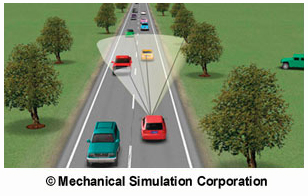
| CarSim is a vehicle simulator utilized by Ohio State University to develop realistic vehicle trajectories |
Acording to National Highway Traffic Safety Administration data, fatal motor vehicle traffic crashes are at their lowest number since 1950.1 Despite this progress, achieving a highway system that is largely free of crashes is a major challenge for society and will require significant technological advancements. As part of the ongoing move towards safer highways, two projects awarded under the Federal Highway Administration's (FHWA) Exploratory Advanced Research (EAR) Program are investigating key technological factors: high-precision vehicle positioning and advanced traffic simulation and evaluation tools. |
"Integrated Global Positioning System and Inertial Navigation Unit (GPS/INU) Simulator for Enhanced Traffic Safety," is a project awarded to Ohio State University to integrate different simulation models to accurately study the relationship between vehicle dynamics and roadway geometry. "Current traffic simulators do not have the capability to properly model vehicle trajectories based on the actions of drivers and vehicle characteristics. In fact, they do not consider lateral movements within the lane at all." explains James Arnold at FHWA. "This project aims to provide an integrated design, testing, and evaluation tool for developing an advanced concept subsystem to enhance vehicle safety at the vehicle and network level."
By combining a GPS/INU simulator with other simulators, including those for vehicle dynamics, traffic, vehicle-to-vehicle (V2V) and vehicle-to-infrastructure (V2I) systems, and a scenario warning generator, the Ohio State University project's integrated simulation system will be capable of providing models and associated crash reports for scenarios ranging from estimated road departures and lane changes to signalized intersection and sudden stop cases. This integrated simulation environment will provide a useful training tool and aid in the design of new roadways and redesign of existing roadways to reduce the risk of crash occurrence.
The research includes testing, in a controlled environment, the capability to send messages to trailing vehicles of a change in a leading vehicle's trajectory due to roadway debris, a change of vehicle trajectory in a crash situation, and the ability to relay pavement condition information.
A second project awarded under the EAR Program also aims for transformational change and overall advances in highway engineering and intermodal surface transportation. "Next Generation Vehicle Positioning in GPS-Degraded Environments for Vehicle Safety and Automation Systems, conducted by Auburn University, aims to improve upon existing techniques and apply them to future safety and automation applications.
David Gibson at FHWA explains, "The next generation of safety and vehicle automation will rely on precise positioning, yet GPS-based positioning is still hampered by blockages of the GPS signal." He continues, "This project takes a different direction and does not rely exclusively on GPS but is instead developing a multifaceted approach to achieving precise positioning, even in situations where the GPS signal is inadequate." Light Detection and Ranging is one approach being examined to accurately establish a vehicle's lateral position on the road, as shown in Figure 1.
The Auburn University project builds on three key technology areas to improve positioning performance:
It is anticipated that the GPS/INU vehicle location technology being examined and developed by Ohio State University will be integrated as a standard feature in every vehicle within the next decade-enabling vehicles, drivers, and transportation operators to observe, record, and disseminate safety information to nearby vehicles via V2V and V2I communications. In addition, the integrated simulation environment has potential beyond the area of crash risk reduction; other areas of interest could include improving energy and fuel consumption, and increasing mobility through reduced travel time and delays.
The mapping and positioning technologies being developed by Auburn University are predicted to ultimately become key elements of a successful cooperative systems environment. As future automation systems bring mobility, environmental, and safety benefits to vehicles and the roads, there will also be a need for increasingly accurate systems to communicate detailed and precise information via wireless communications. The technology could be developed for use in hybrid vehicle powertrain control for anticipating elevation changes and therefore improving fuel efficiency. It is anticipated that vehicle manufacturers could also utilize extensive knowledge of the road environment to tune safety systems to adapt to conditions in real time.
 |
| Figure 1. Light Detection and Ranging data can be fused with other vehicle positioning technologies to calculate position, velocity, and attitude. |
For more information on the Ohio State University project, contact James Arnold at FHWA, 202-493-3265. For more information on the Auburn University project, contact David Gibson at FHWA, 202-493-3271 (email: david.gibson@dot.gov).

What Is the Exploratory Advanced Research Program?FHWA’s Exploratory Advanced Research (EAR) Program focuses on long-term, high-risk research with a high payoff potential. The program addresses underlying gaps faced by applied highway research programs, anticipates emerging issues with national implications, and reflects broad transportation industry goals and objectives. To learn more about the EAR Program, visit the Exploratory Advanced Research Web site at www.fhwa.dot.gov/advancedresearch. The site features information on research solicitations, updates on ongoing research, links to published materials, summaries of past EAR Program events, and details on upcoming events. For additional information, contact David Kuehn at FHWA, 202-493-3414 (email: david.kuehn@dot.gov), or Terry Halkyard at FHWA, 202-493-3467 (email: terry.halkyard@dot.gov). |
1"Traffic Safety Facts: Research Note - Summary of Statistical Findings," National Highway Traffic Safety Administration, Washington, DC, 2010.