U.S. Department of Transportation
Federal Highway Administration
1200 New Jersey Avenue, SE
Washington, DC 20590
202-366-4000
Federal Highway Administration Research and Technology
Coordinating, Developing, and Delivering Highway Transportation Innovations
 |
| This fact sheet is an archived publication and may contain dated technical, contact, and link information |
|
Publication Number: FHWA-HRT-07-029
Date: January 2007 |
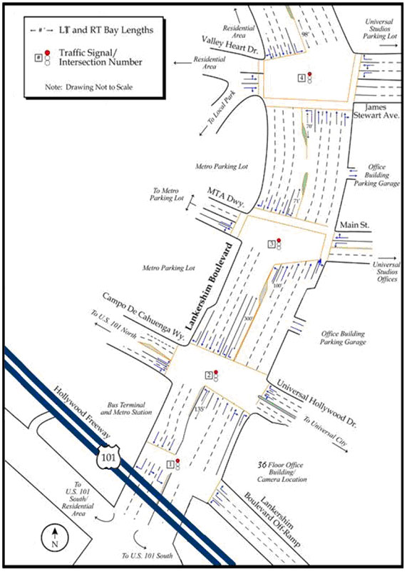
Lankershim Boulevard DatasetPDF version of Fact Sheet (175 KB) To support the development of algorithms for driver behavior at the microscopic level, the Next Generation SIMulation (NGSIM) program is collecting detailed, high-quality traffic datasets. NGSIM stakeholder groups identified the collection of real-world, vehicle trajectory data as important to understanding and researching driver behavior at a microscopic level. The NGSIM datasets represent the most detailed and accurate field data collected to date for traffic microsimulation research and development. The Lankershim Boulevard dataset was one of several datasets collected under the NGSIM program. DescriptionResearchers for the NGSIM program collected detailed vehicle trajectory data on Lankershim Boulevard in the Universal City neighborhood of Los Angeles, CA, on June 16, 2005. The study area, which consisted of bidirectional data of the three to four lane arterial segments and complete coverage of three signalized intersections, was approximately 500 meters (1,600 feet) in length. These data were collected using five video cameras mounted on the roof of a 36-story building located adjacent to the U.S. Highway 101 and Lankershim Boulevard interchange in the Universal City neighborhood. NG-VIDEO, a customized software application developed for the NGSIM program, transcribed the vehicle trajectory data from the video. This vehicle trajectory data provided the precise location of each vehicle within the study area every one-tenth of a second, resulting in detailed lane positions and locations relative to other vehicles. A total of 30 minutes of data are available in the full dataset, which are segmented into two 15-minute periods (8:30 a.m. to 8:45 a.m. and 8:45 a.m. to 9:00 a.m.). These periods represent primarily congested conditions on the arterial. In addition to the vehicle trajectory data, the Lankershim dataset also contains computer-aided design and geographic information system files, aerial ortho-rectified photos, loop detector data, raw and processed videos, signal timings, traffic sign information and locations, windshield videos, weather data, and aggregate data analysis reports. The full Lankershim dataset is freely available at the NGSIM Web site at http://ops.fhwa.dot.gov/trafficanalysistools/ngsim.htm. BenefitsNGSIM researchers used the Lankershim dataset to estimate and validate a model for lane changing on congested arterial corridors. This model, referred to as the Arterial Lane Selection model, considers both preemptive lane positioning behaviors and more aggressive overtaking behaviors when obstructions are encountered. The dataset enabled researchers to understand the lane-changing behavior of drivers on arterials at a level of detail and accuracy not available previously. The Arterial Lane Selection model can be incorporated into traffic microsimulation models, which will help transportation practitioners make more reliable and valid transportation decisions. Researchers within the broader traffic simulation community also are using the Lankershim dataset to examine other driver behaviors on arterials, such as drivers’ responses to the yellow intervals at traffic signals, cooperative and forced driving behaviors on congested arterials, queue move-up and discharge behaviors at traffic signals, and drivers’ starting behaviors at the beginnings of the green intervals at traffic signals. In addition, researchers are using the Lankershim dataset to validate and calibrate existing microsimulation algorithms and models.
Publication No. FHWA-HRT-07-029 PDF files can be viewed with the Acrobat® Reader® |
|
Updated: 09/08/2017
|