U.S. Department of Transportation
Federal Highway Administration
1200 New Jersey Avenue, SE
Washington, DC 20590
202-366-4000
Federal Highway Administration Research and Technology
Coordinating, Developing, and Delivering Highway Transportation Innovations
 |
| This techbrief is an archived publication and may contain dated technical, contact, and link information |
|
Publication Number: FHWA-HRT-08-049
Date: May 2008 |
|||||||
Surrogate Safety Assessment Model (SSAM)FHWA Contact: Joe Bared, This document is a technical summary of the Federal Highway Administration report, Surrogate Safety Assessment Model and Validation: Final Report, FHWA-HRT-08-051. PDF Version (221 KB)
PDF files can be viewed with the Acrobat® Reader® OBJECTIVEThe safety of intersections, interchanges, and other traffic facilities is most often assessed by tracking and analyzing police-reported motor vehicle crashes over time. Given the infrequent and random nature of crashes, this process is slow to reveal the need for remediation of either the roadway design or the flow-control strategy. This process is also not applicable to assess the safety of roadway designs that have yet to be built or flow-control strategies that have yet to be applied in the field. This TechBrief summarizes the research and development of the Surrogate Safety Assessment Model (SSAM), a technique combining microsimulation and automated conflict analysis, which analyzes the frequency and character of narrowly averted vehicle-to-vehicle collisions in traffic, to assess the safety of traffic facilities without waiting for a statistically above-normal number of crashes and injuries to actually occur.
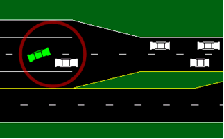
IntroductionA conflict is a scenario where two road users will likely collide without evasive action. Figure 1 illustrates an example of a conflict, where a vehicle is angling across two lanes to the left-turn bay and has abruptly cut in front of another vehicle that must decelerate to avoid collision. Traffic conflicts have been studied since the late 1960s as a technique to assess the safety of a location, with the understanding that conflict frequency is correlated with the risk of actual collision. Conflict studies traditionally utilize personnel trained to identify and record conflicts observed at an intersection. In this research, the SSAM software application was developed to automate conflict analysis by directly processing vehicle trajectory data. Researchers specified an open-standard, “universal” vehicle trajectory data format designed to provide the location and dimensions of each vehicle approximately every tenth of a second. It is hoped that video processing technology will, in the coming years, be capable of automatically extracting vehicle trajectory data adequate for SSAM processing. However, the trajectory file format is currently supported as an export option by four traffic microsimulation models: VISSIM, AIMSUN, Paramics, and TEXAS. Assessment MethodTo assess a traffic facility with SSAM, the facility is first modeled in one of the aforementioned simulation models and then simulated with desired traffic conditions (typically simulating several replications with different random number seeds). Each simulation run results in a corresponding trajectory file, referred to as a TRJ file corresponding to the .trj filename extension. Then, SSAM is used as a post-processor to analyze the batch of TRJ files. SSAM analyzes vehicle-to-vehicle interactions to identify conflict events and catalogs all events found. For each such event, SSAM also calculates several surrogate safety measures, including the following:
SSAM provides the following features:
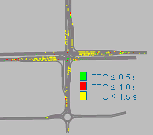
Figure 2 is a screenshot of the map display in SSAM, with conflict icons color coded according to their time-to-collision values.
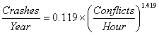
ValidationTo assess the capabilities of SSAM, researchers conducted theoretical validation, field validation, and sensitivity analysis. The theoretical validation effort considered 11 pairs of intersection designs (e.g., right-turn bay versus no right-turn bay; SPUI versus diamond interchange; roundabout versus diamond interchange). The relative safety assessments of SSAM were compared to assessments using traditional, theoretical crash-prediction equations. The results yielded interesting insights, though it was often the case that design A had more conflicts than design B, while design B had higher severity conflicts than design A, pointing to the need for further research in interpreting and comparing surrogate safety measures. The field validation effort was concerned with the absolute accuracy of surrogate safety assessment, in contrast to the relative safety assessments of the theoretical validation. A set of 83 field sites were selected—all were four-leg, urban, signalized intersections—and were modeled in VISSIM and simulated and assessed with SSAM. The conflict analysis results of these intersections were compared to actual crash histories (based on historical insurance claims records) using five statistical tests. This effort also provided an opportunity for benchmark comparison of surrogate safety estimates versus traditional crash-prediction models based on average daily traffic volumes (ADT). The simulation-based intersection conflicts data provided by SSAM were significantly correlated with the crash data collected in the field, with the exception of conflicts during path-crossing maneuvers (e.g., left turns colliding with opposing through-traffic), which were under-represented in the simulation. Intersection rankings based on total conflict frequency correlated with intersection rankings based on total crash frequency with a Spearman rank coefficient of 0.463 (and similarly for rear-end and lane-change incidents). The relationship between total conflicts and total crashes in this study (shown in figure 3) exhibits a correlation (R-squared) value of 0.41.
This correlation of conflicts to crashes is consistent with the range of correlations reported in several studies between ADT and crashes for urban, signalized intersections. This result was achieved despite simulating only morning peak-hour volumes. Crash prediction models based on a yearly average of 24-hour ADT volumes exhibited a correlation (R-squared) value of 0.68 with actual crash frequencies. This study also found a conflict-to-crash ratio of approximately 20,000 to 1, though that ratio varied by conflict type. The sensitivity analysis effort compared an assessment of five intersections (of the aforementioned 83) conducted separately using each of the four microsimulation models: VISSIM, AIMSUN, Paramics, and TEXAS. Crashes (vehicles driving through each other) were found in all simulations, and SSAM proved particularly useful in revealing questionable simulated behavior (due to user-configuration of the model in some cases and underlying simulation logic in other cases). This has notably prompted some revisions (so far by TEXAS and VISSIM) to improve the behavior of the underlying simulation models. RecommendationsSSAM provides a compelling new option to assess the safety of traffic facilities using popular microsimulation software. This approach circumvents the need to wait for “abnormally high” crashes to actually occur, allows assessments of hypothetical designs and control alternatives, and is applicable to facilities where traditional, volume-based crash-prediction models (and norms) have not been established. Research is ongoing in this area, and as simulation models and video technology improve, this technique is expected to grow in use. Additional InformationSSAM documentation is available in two FHWA reports: Surrogate Safety Assessment Model and Validation: Final Report, FHWA-HRT-08-051 and Surrogate Safety Assessment Model (SSAM): Software User Manual, FHWA-HRT-08-050 (https://www.fhwa.dot.gov/publications/research/safety/08050/). The SSAM software and open source code is available from Siemens Energy and Automation.
|