U.S. Department of Transportation
Federal Highway Administration
1200 New Jersey Avenue, SE
Washington, DC 20590
202-366-4000
Federal Highway Administration Research and Technology
Coordinating, Developing, and Delivering Highway Transportation Innovations
| SUMMARY REPORT |
| This summary report is an archived publication and may contain dated technical, contact, and link information |
|
Publication Number: FHWA-HRT-04-082
Date: March 2004 |
|||||||||||||||||||||||||||||||||||||||||||||||||||||||||||||||||||||||||||||||||
Summary Report: Evaluation of Lane Reduction "Road Diet" Measures and Their Effects on Crashes and InjuriesPDF Version (214 kb)
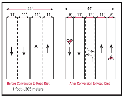
PDF files can be viewed with the Acrobat® Reader® Table of Contents "ROAD DIETS" ARE OFTEN CONVERSIONS OF FOUR-LANE UNDIVIDED ROADS INTO THREE lanes (two through lanes and a center turn lane), as shown in figure 1. The fourth lane may be converted to bicycle lanes, sidewalks, and/or on-street parking. In other words, existing space is reallocated; the overall area remains the same. Under most average daily traffic (ADT) conditions tested, road diets have minimal effects on vehicle capacity, because left-turning vehicles are moved into a common two-way left-turn lane.(1,2) However, for road diets with ADTs above approximately 20,000 vehicles, there is a greater likelihood that traffic congestion will increase to the point of diverting traffic to alternate routes. Road diets can offer potential benefits to both vehicles and pedestrians. On a four-lane street, drivers change lanes to pass slower vehicles (such as vehicles stopped in the left lane waiting to make a left turn). In contrast, drivers' speeds on two-lane streets are limited by the speed of the lead vehicle. Thus, road diets may reduce vehicle speeds and vehicle interactions during lane changes, which potentially could reduce the number and severity of vehicle-to-vehicle crashes. Pedestrians may benefit because they have fewer lanes of traffic to cross, and because motor vehicles are likely to be moving more slowly. The Federal Highway Administration (FHWA) report Safety Effects of Marked vs. Unmarked Crosswalks at Uncontrolled Locations found that pedestrian crash risk was reduced when pedestrians crossed two- and three-lane roads, compared to roads with four or more lanes.(3)
Although road diet advocates enumerate these potential crash-related benefits, there has been limited research concerning such benefits. This study was designed to help fill this gap. MethodologyDatabases Used This study evaluated road diets at several locations in California and Washington. Because both States are part of FHWA's Highway Safety Information System (HSIS), researchers believed that the necessary high-quality crash data for a large number of crash, roadway, and vehicle variables would be available from computerized HSIS files. However, because all the road diets were found to be on non-State routes, the data were collected manually from local agency files. Research Design Researchers selected a treatment and comparison group, and obtained data for two time periods: one before and one after treatment installation. The road diets (i.e., treatment sites) were matched with four-lane streets that were otherwise similar (i.e., comparison sites). Researchers then obtained crash data for four groups: 1) Road diets-before period. Most comparison sites were four-lane undivided roads that were near the road diets (such as a parallel road one or two blocks away, or a perpendicular road). A few comparison sites were four-lane undivided sections of the same road beyond the location where the road diet was installed. The comparison sites were selected to be similar to the road diets in terms of roadway functional class, type of development (e.g., commercial or residential), speed limit, intersection spacing, and access control. Site Selection Local traffic engineers in California and Washington were contacted to determine where road diets were located. Road diets were identified in eight cities: Bellevue, WA, Mountain View, CA, Oakland, CA, Sacramento, CA, San Francisco, CA, San Leandro, CA, Seattle, WA, and Sunnyvale, CA. These are not the only cities in California and Washington that have road diets, but they are the locations that the local traffic engineers provided. Researchers identified candidate comparison sites by reviewing maps and talking to local traffic engineers. The final list of sites contained 30 road diets and 50 total matching comparison sites in 8 cities. Because of missing crash data, only 12 road diets and 25 comparison sites are included in this analysis, as described below. The road diet sections ranged from 0.13-4.09 kilometers (km) (0.08-2.54 miles (mi)). The comparison sites sections ranged from 0.21-4.88 km (0.13-3.03 mi). Data Collection Local traffic engineers provided crash and ADT data for the road diets and comparison sites. At most locations, 1 or more years of data were obtained for each of the before and after periods. The actual time periods varied considerably from site to site, depending on how much data the city had available and when the road diet was installed. Because all four seasons were represented, seasonal variations in crashes were taken into account. AnalysisAs noted above, researchers initially obtained crash data for 30 road diets and 50 comparison sites. However, many locations had small sample sizes of crashes because of short segment lengths, short data periods, or low ADTs. Therefore, a subset of 12 road diets (2,068 crashes) and 25 comparison sites (8,556 crashes) was chosen for the analyses that are reported here. These locations generally had segment lengths of at least 0.81 km (0.50 mi). The road diets and comparison sites were placed into 11 groups, each consisting of 1 or 2 road diets and the matching comparison site(s). The road diets and comparison sites in each group were located in the same city, thereby accounting for possible differences in crash-reporting practices among cities. Table 1 lists the cities, the number of road diets and comparison sites, and the number of crashes. The before and after analyses were divided into four categories: 1) Crash frequencies.
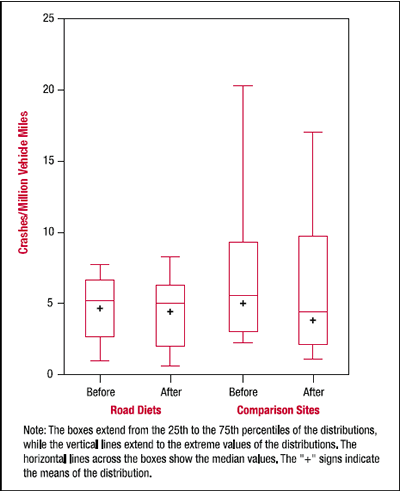
ResultsBefore and After Crash Frequencies This analysis used 10 groups, with 11 road diets and 24 comparison sites. One road diet and one comparison site in Seattle, WA, were excluded because of inconsistent before and after periods. When researchers pooled data from all 10 groups, a somewhat higher percent of crashes at the comparison sites occurred in the after period than at the road diet sites (41.0 percent vs. 35.8 percent). A Cochran- Mantel-Haenszel test of overall significance across the 10 groups was statistically significant (X2 1df = 7.5307, p = 0.0061). The estimated risk ratio indicates the percent of crashes at road diet sites in the after period to be about 6 percent less likely than a crash at a comparison site, with 95-percent confidence limits of 0.003 and 0.106. Thus, on average, crash frequencies at road diets in the after period were approximately 6 percent lower than at the corresponding comparison sites. Where before and after ADTs were available, researchers examined changes on road diets and comparison sites to determine if motorists were diverting off road diets and onto comparison sites. The ADTs on four road diets sites increased by 6.4 percent. A slightly higher increase of 8.0 percent occurred on the 9 matching comparison sites. Thus, for the sites included in this analysis, any road diet diversionary effect was limited. Instead, the dominant phenomenon was an overall increase in ADT as a result of population growth and other factors. Crash Rates The crash rate analysis included 8 groups with reliable ADT data-8 road diets and 14 comparison sites. The ADTs on the road diets ranged from 8,133-5,658 in the before period and from 8,300-16,482 in the after period. The ADTs on the comparison sites ranged from 5,480-24,183 in the before period and from 7,006-26,100 in the after period. Negative binomial regression models were fit to the crash frequencies at each site. The explanatory variables were traffic volume (millions of vehicles), city or alternatively group, site type (road diet or comparison site), time period (before or after), and a site type-by-time-period interaction. Segment length was included as a constant factor (i.e., the number of crashes on a segment was proportional to its length). More information about negative binomial regression models can be found in McCullagh and Nelder.(4) (A later attempt was made to use Empirical Bayes before/after methods as described by Hauer, but was not possible due to sample limitations.(5)) The results showed highly significant variation in crash rates with traffic volume and city, and lesser variation with site type (i.e., treatment vs. comparison). The city-by-city variations noted are probably the result of different operational conditions and crash-reporting practices. Figure 2 shows the distributions of crash rates (per million vehicle miles) for road diets and comparison sites in the before and after periods. The distributions of crash rates at the road diets were less variable than those at the comparison sites. The mean crash rates at the road diets were slightly lower than at the comparison sites. At both the road diets and comparison sites, the crash rates decreased from the before period to the after period. The extent of the decrease was virtually the same at both road diets and comparison sites, and was not statistically significant. Thus, this rate analysis did not indicate a significant safety effect. Crash Severity The crash severity analysis included 10 groups, with 10 road diets and 20 comparison sites. The total number of crashes was 7,919. Because of local reporting practices in San Francisco, CA, many property damage only (PDO) crashes were not reported. Therefore, two road diets and five comparison sites in that city were excluded from this analysis.
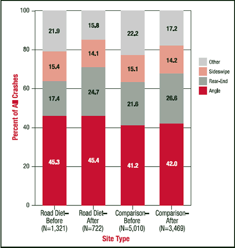
A crash was classified as PDO if no injuries and no fatalities occurred. Otherwise, it was classified as injury and fatality. Overall, approximately 63 percent (5,007) of the crashes resulted in no injuries or fatalities. The remaining 37 percent (2,912) of the crashes had at least one injury or fatality. These percentages were quite similar for both road diets and comparison sites in both the before and after time periods. However, injury rates varied somewhat from city to city and among the matched groups of sites. To account for this variation, a logistic regression model was fit to the injury severity data (no injury or injury/fatality). The explanatory variables in the model were: 1) Matched group. McCullagh and Nelder Nelder provide an explanation of logistic regression models.(4) The results showed that group was the only significant factor (X2 9df = 347.69, p < 0.0001). Crash severity was virtually the same at road diets and comparison sites, and did not change from the before to the after time period. The city-by-city variations are most likely the result of different crash-reporting practices in each city. It was thought that injury and fatal crashes would decrease on road diets relative to comparison sites, assuming lower vehicle speeds on road diets in the after period. However, before-and-after speed data were not available, so it cannot be determined if vehicle speeds changed. It is possible that road diets could have resulted in fewer serious (i.e., "A") injuries and more moderate or minor ("B" or "C") injuries, relative to comparison sites. Such a result would not be apparent from the crash data, because information on the specific level of injury was not contained in the data. Crash Types Three crash types-angle, rear-end, and sideswipe-accounted for about 80 percent of all crashes (figure 3). Although the crash type distributions were quite similar for the site-type-by-time-period interaction, angle collisions were somewhat higher for the road diets, and perhaps decreased somewhat less in the after period, relative to the comparison sites. To investigate this, a logistic regression model was fit to a crash type variable (angle vs. all other) using the same explanatory variables as the crash severity model. The results from this model again indicated a highly significant effect due to group (X2 9df = 199.24, p < 0.0001). Site type was also statistically significant (X2 1df = 13.24, p = 0.0003), with the proportion of angle collisions higher on road diets than on comparison sites. Neither time period nor the site-type-by-time-period interaction was significant (p = .5862 and p = .9575, respectively). A similar model showed the proportion of rear-end crashes to be higher for the comparison sites than for the road diets, again with no significant period or interaction effects. The only significant effect in a model for sideswipe crashes was the effect due to group.
It is not clear why the crash type distributions were different between the road diets and the comparison sites, because crash severity was virtually the same at road diets and comparison sites. One possible reason is that such differences do exist from one roadway section to another because of variations in the numbers of driveways and intersections, vehicle speeds, vehicle mix, area type, and other factors. It may be that cities selected roadway sections for road diet installation at least partly because of such factors. The variations in the crash type distributions among groups may be the result of how each city classifies and reports crashes. For example, all of the California cities included angle/turning crashes in the total number of right angle crashes, but in Bellevue, WA, and Seattle, WA, angle/turning and right angle crashes were two separate crash types. Summary of Findings The key findings of this study are summarized below and in table 2. 1) Crash frequencies at road diets in the after period were approximately 6 percent lower than at the corresponding comparison sites.
Conclusions and RecommendationsThis study found that a significantly lower (approximately 6 percent) proportion of crashes occurred at road diets in the after period than at comparison sites in the after period. However, no significant change was found in crash rate decreases between road diets and comparison sites. Thus, one may expect that converting a roadway segment from four-lane undivided to three lanes likely would reduce total crashes by 6 percent or less. Road diets were no better or worse than comparison sites with regard to crash severity. Additional research is needed to determine whether the crash reductions observed on road diets can be attributed to lower speeds, fewer conflicts, or possibly other factors. There is a need for future safety and operational studies, under a range of traffic volumes and other conditions, to help identify the situations where road diets would be appropriate. In addition, traffic operations and capacity must be considered fully at a given site before implementing road diets and other lane reduction measures. References
For more InformationThis research was conducted by Herman F. Huang, J. Richard Stewart, and Charles V. Zegeer of the University of North Carolina Highway Safety Research Center. The final report, Evaluation of Lane Reduction "Road Diet" Measures on Crashes and Injuries, can be found in Transportation Research Record 1784. For more information about HSIS, contact Carol Tan, HSIS Program Manager, HRDS, 202-493-3315, carol.tan@fhwa.dot.gov. The Highway Safety Information System (HSIS) is a multi-State safety database that contains crash, roadway inventory, and traffic volume data for a select group of States. The participating States, California, Illinois, Maine, Michigan, Minnesota, North Carolina, Ohio, Utah, and Washington, were selected based on the quality of their data, the range of data available, and their ability to merge the data from the various files. The HSIS is used by FHWA staff, contractors, university researchers, and others to study current highway safety issues, direct research efforts, and evaluate the effectiveness of accident countermeasures. |
|||||||||||||||||||||||||||||||||||||||||||||||||||||||||||||||||||||||||||||||||