U.S. Department of Transportation
Federal Highway Administration
1200 New Jersey Avenue, SE
Washington, DC 20590
202-366-4000
Federal Highway Administration Research and Technology
Coordinating, Developing, and Delivering Highway Transportation Innovations
 |
| This report is an archived publication and may contain dated technical, contact, and link information |
|
Publication Number: FHWA-HRT-05-093
Date: July 2006 |
Federal Highway Administration University Course on Bicycle and Pedestrian TransportationPDF Version (366 KB) PDF files can be viewed with the Acrobat® Reader®
LESSON 5: LAND USE REGULATIONS TO ENCOURAGE NONMOTORIZED TRAVEL
5.1 IntroductionLand use and transportation have an extremely complex interrelationship. Often, problems with the transportation system are blamed on faulty land use policies, and problems with sprawling land use are blamed on transportation policies. In fact, the problems typically do not have simple cause-and-effect solutions. This lesson takes a look at ways in which land use regulations can be improved to support an intermodal transportation system that encourages access by walking, bicycling, and transit. Most communities in the United States have land use regulations that primarily support automobile access to local destinations. Substantial changes to zoning laws and subdivision regulations will be necessary in many communities in order to accomplish fundamental improvements to the transportation system. In addition to ordinances that require bicycle parking and sidewalks, even more basic changes are needed for automobile parking requirements, street design standards, allowable land use densities, and transit-oriented developments. Revising regulations that have been in place for many years can be a daunting task—either for planners who are trying to remodel a development ordinance or for engineers who are trying to change street design standards to accommodate bicycle and pedestrian travel. This lesson provides some examples of the types of provisions that are included in new policies at the State and local levels in order to accommodate and encourage bicycle and pedestrian travel. The major sections of this lesson are as follows:
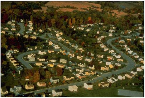
5.2 Pedestrian-Oriented Land UseOne of the most important factors in a person’s decision to walk or bike is the proximity of goods and services to homes and workplaces. The most conducive land use for pedestrian activity is one with a higher density mix of housing, offices, and retail (see figure 5-1). Studies have also shown that more people walk in areas that are able to achieve higher densities of either housing or employment, despite lower densities of other uses such as retail. One study of the Puget Sound Region in Washington State defines high density as 50 to 75 employees per acre or 9 to 18 residents per acre. Zoning and Subdivision RegulationsPedestrian and bicycle travel is often an afterthought in the development process. The results are impassable barriers to pedestrian travel, both within and between developments. The examples below show how local zoning ordinances can be amended to require more attention to the needs of pedestrians and bicyclists. Subdivision Layout. A residential subdivision layout (including planned unit developments) should provide safe, convenient, and direct bicycle and pedestrian access to nearby [within 0.4 km (0.25 mi) for walking and 3.2 km (2 mi) for bicycling] and adjacent residential areas, bus stops, and neighborhood activity centers such as schools, parks, commercial and industrial areas, and office parks.
Figure 5-1. Photo. Low-density, single-use zoning creates trip distances that are too great to make walking a viable transportation option. Cul-de-Sacs.Cul-de-sacs have proven to be effective in restricting automobile through traffic; however, they can also have the effect of restricting bicycle and pedestrian mobility unless public accessways are provided to connect the cul-de-sac with adjacent streets (see figures 5-2 and 5-3). Trail connections between cul-de-sacs and adjacent streets should be provided wherever possible to improve access for bicycles and pedestrians.
Figure 5-2. Illustration. Cul-de-sacs can restrict pedestrian and bicycle access.
Figure 5-3. Illustration. Loops are preferred to cul-de-sacs. Future Extension of Streets. During subdivisions of properties, streets, bicycle paths, and sidewalks should be designed to connect to adjacent properties that are also likely to be subdivided in the future, so that a secondary system of roads and sidewalks develops over time. When subdivisions are built with only one outlet to a main thoroughfare, the result is heavy traffic congestion and difficult intersections for both motorists and pedestrians. Inclusion of Bicycle and Pedestrian Facilities in Piecemeal Development. This is intended to ensure that pedestrian and bicycle facilities are included in projects that occur in a piecemeal fashion. For projects in which only part of the land owned by the applicant is proposed for development, a sketch plan showing the tentative locations of streets, bicycle facilities, and public accessways should be submitted for the entirety of the land owned. Stub-outs (open connections for future development) should be constructed for bicycle and pedestrian facilities onsite, and the next construction phase should be designed to connect to this network. Internal Bicycle/Pedestrian Circulation for Commercial and Business Developments. Adequate provisions should be made for bicycle and pedestrian circulation between buildings and related uses on development sites. The Americans with Disabilities Act (ADA) also contains regulations for onsite circulation. Lot Coverage. Zoning codes should be amended to raise the allowable lot coverage along bus routes to encourage intensified and more efficient uses of land in these areas. Parking in High-Density Residential Developments. In some high-density residential areas, existing regulations require off-street parking and, at the same time, a reduced lot frontage. This results in home fronts that primarily consist of garage doors. Ordinances should be modified to allow for rear-lot access (alleyways) or other innovative solutions in these areas (see figure 5-4).
Figure 5-4. Illustration. Typical alley: ordinances should be modified to allow for rear-lot access. Parking Reductions. Parking codes should be modified to allow a reduced parking option for developments that are located on bus routes and provide facilities that encourage bicycling and walking. In general, shopping center parking lots should not be designed to handle volumes that occur only once or twice per year, but rather more typical volumes. Compliance with Design Standards. Bicycle and pedestrian facilities should be designed to meet local and statewide design standards. Community VisioningMany communities throughout the country are conducting extensive revisions to their zoning and subdivision regulations in light of new planning techniques that improve transportation and community design. New rules that would allow parking reductions and higher density developments are likely to be controversial. Public education for citizens and elected officials is essential to gain popular support for these new regulations. The city of Portland, OR, recently conducted an extensive revision of local zoning and subdivision regulations by using a successful technique that encouraged involvement from citizens and local elected officials. The city conducted a well-publicized Visual Preference Survey™ that allowed local citizens to establish a vision of their ideal community environment by comparing photographs of different styles of urban, suburban, and rural development. When shown side-by-side, photographs of suburban strip development were rated far lower than those showing more compact, mixed-use districts.(1) Development Review ProcessLand developers should be asked to submit a pedestrian and bicycle mobility plan early during the site plan review process. This plan should provide an inventory of all existing and proposed land uses adjacent to the site, and illustrate a logical circulation plan for pedestrians and bicycles within the development and between adjacent land uses. The questions in table 5-1 below can help design professionals create site plans that are sensitive to the needs of pedestrians.
Table 5-1. Site plan checklist.
5.3 Commercial Development Design GuidanceThe physical layout of a development can often make the difference in a person’s choice to walk between stores or to adjacent developments. Careful attention should be given to the location of buildings as well as the configuration of parking lots. Several provisions can ensure a better walking environment in commercial and office developments. Building Setbacks. Buildings should not automatically be separated from the street by parking lots—this discourages pedestrian access and primarily serves those who arrive by automobile. A maximum setback requirement of 4.6 to 7.6 m (15 to 25 ft) can help to encourage pedestrian activity. Parking, driving, and maneuvering areas should not be located between the main building entrance and the street. Parking lots should be located on the side and rear yards of the property whenever possible. For developments with multiple buildings, direct pedestrian access to public transit should be provided by clustering buildings near bus stops. Building Orientation and Facades. Main building entrances should be oriented to face the street designated as a bus route. Entrances and paved walkways should lead directly to a bus stop. Visual stimulation is very important to pedestrians—long, blank walls with no openings onto the street discourage walking. Building facades should maintain continuity of design elements such as windows, entries, storefronts, roof lines, materials, pedestrian spaces and amenities, and landscaping. Parking garages on streets with bus service should have ground-floor street frontage developed for office, retail, or other pedestrian-oriented uses. Onsite Walkways. For developments with multiple buildings and/or outparcels, all building entrances on the site should be connected by walkways to encourage walking between buildings and to provide a safe means of travel for pedestrians. Sidewalks between the building edge and parking lots should allow pedestrians safe and convenient access to building entrances without having to walk within driving aisles of parking lots. Pedestrian Access Between Adjacent Developments. To encourage walking instead of driving between uses on the development site, sidewalks should connect those uses to adjacent activity centers. Barriers such as fences or vegetation should not be placed so as to hinder access between developments. Lighting. Pedestrian-scale lighting should be designed to light the walkway, thereby increasing pedestrian safety. Pedestrian lighting should be used in addition to lighting provided for motorists’ safety. Time-Saver Standards for Landscape Architecture includes an excellent chapter on desirable lighting levels for pedestrian facilities, and table 5-2 specifies the following levels of illumination for sidewalks:(2)
Table 5-2. Levels of illumination for sidewalks.
Improvements Between the Building and the Street. Design elements in the area between the building and the street are critical to successful pedestrian spaces. The streetscape should provide visual interest for the pedestrian. The area should be landscaped if project budgets allow. Parking Lot Design. Parking lots with 50 or more spaces should be divided into separate areas with walkways and landscaped areas in between that are at least 3.0 m (10 ft) in width. Pedestrian paths should be designed with minimal direct contact with traffic. Where pedestrian paths cross the traffic stream, raised speed tables that slow cars while providing an elevated pedestrian walkway should be provided. Additional recommendations for pedestrian-oriented parking lots include:
Bicycle Parking. Provision of bicycle parking at destinations is crucial—without it, bicycling becomes far less convenient. Bicycle parking ordinances can help to improve the situation (see lesson 22 for a full description).
5.4 Performance-Based Code as a Development (or Redevelopment) ToolPerformance or form-based code is a planning technique used to establish desired aesthetics and design standards for a specific location—such as a street corridor that is undergoing redevelopment—to achieve a balanced, pedestrian-friendly environment. In Arlington, VA, form-based code has been used to establish design parameters for Columbia Pike, a five-lane urban arterial that is currently dominated by motor vehicle traffic and lies within a rapidly redeveloping area. The Columbia Pike Special Revitalization District Form Based [sic] Code has the following purpose:(3)
The Form Based Code contains the following elements:
For more information on performance-based codes, refer to the resources at the end of this lesson.
5.5 Guidance on Designing Residential Communities That Encourage WalkingSuburban neighborhood design can be modified to encourage bicycling and walking. It is not necessarily more expensive to build such communities; however, they require more careful design on the part of the developer. These types of pedestrian-friendly neighborhoods are worth the effort. Recent studies suggest that homes sell quickly in these communities. (See lesson 6 for a more complete description of traditional neighborhood development.) A pedestrian-oriented neighborhood should include the following aspects (the list below is taken from the ITE Journal article titled "Neo–Traditional Neighborhood Design and Its Implications for Traffic Engineering"):(4)
5.6 Student ExerciseZoning and subdivision regulations often pose a significant barrier to implementing the design features discussed in this lesson. While some land development regulations have been revised to encourage the construction of multimodal neighborhoods and commercial areas, unforeseen complications often get in the way of achieving the livable community that was envisioned. The purpose of this lesson is to learn more about the development process and the reasons behind final outcomes in the built environment.
Prepare a paper (five pages or less) that summarizes your research and provides conclusions that explain the reasons why desirable—and undesirable—features of the development occurred. A few tips: Avoid selecting a development that is not yet completed, since some pedestrian and bicycle features are sometimes built later in the development process (such as shared-use path networks). When calling the local planning department of the jurisdiction responsible for the project, ask to speak with one of the planners who was responsible for working with the developer. For extra credit, speak with the developer of the property, and ask his/her perspective about aspects of the development that were successful and unsuccessful in his/her opinion, particularly in accommodating pedestrians and bicyclists.
5.7 References and Additional ResourcesThe references for this lesson are:
Additional resources for this lesson include:
FHWA-HRT-05-093 |