U.S. Department of Transportation
Federal Highway Administration
1200 New Jersey Avenue, SE
Washington, DC 20590
202-366-4000
Federal Highway Administration Research and Technology
Coordinating, Developing, and Delivering Highway Transportation Innovations
 |
| This report is an archived publication and may contain dated technical, contact, and link information |
|
Publication Number: FHWA-HRT-05-137
Date: July 2006 |
Evaluation of Safety, Design, and Operation of Shared-Use PathsFinal ReportPDF Version (1172 KB) PDF files can be viewed with the Acrobat® Reader®
CHAPTER 8. LOS PROCEDUREINTRODUCTIONThe previous chapters have shown how the study team gathered the raw materials needed to fulfill the objective of the research–a new LOS procedure for shared-use paths. The necessary literature is gathered in chapter 2, the theory is developed in chapter 3, the operational data is collected in chapters 4 and 5, and the perceptions of the path users are in chapters 6 and 7. In this chapter, we bring all this together to propose, justify, and demonstrate the use of the new method. Note that much of the information in this chapter is also in the User's Guide that accompanies this report. This chapter contains more technical detail on the development of the procedure, while the User's Guide contains more practical information for the user, such as case study applications of the procedure; however, much of the information is common to both. The new LOS procedure is intended primarily for trail planners, designers, and managers, which include professionals from a wide variety of disciplines (e.g., planners, landscape architects, transportation engineers, bicycle and pedestrian transportation specialists, and park and recreation planners and managers). It may also be useful for trail, bicycle, and pedestrian advocates; elected officials; planning and park commissioners; and other members of the public, especially those individuals who find themselves involved in trail planning efforts or situations involving trail user conflicts that stem from high volumes and diverse mode mixes. These conditions are increasingly common on trails located in urban, suburban, and high-use recreational areas. The LOS procedure can be used for a variety of trail planning tasks where quantitative evaluation is needed to assist in solving design or management problems, including:
TYPES OF SHARED-USE PATHS TO WHICH THIS STUDY APPLIESReaders of this report may understand the term shared-use path (or multi-use trail) to be applicable to a very wide range of facility types and settings. It is important to note that the LOS procedure introduced in this chapter was not developed to be applicable to every type of shared-use path. The list below describes the limits of the study and the specific applicability of its findings:
LOS DEFINEDFor motor vehicles on roadways, the HCM defines LOS as a quality measure describing operational conditions within a traffic stream, generally in terms of such service measures as speed and travel time, freedom to maneuver, traffic interruptions, and comfort and convenience.(4) The HCM defines six levels of service for any particular facility type and uses letters from A through F to represent them (from best to worst). Each LOS represents a range of operating conditions. Although there has been some discussion of this in the literature, safety is not included in the measures that establish motor vehicle service levels. The trail LOS procedure developed through this research is similar to that used for motor vehicle LOS. These similarities include:
However, there are some key differences, including that the trail LOS does not factor in travel time or traffic interruptions such as signals or stop signs at grade crossings. It is important to note that there are a host of other factors that the reader may think are important to consider in a trail user's assessment of comfort and enjoyment of a trail, such as:
Just as motor vehicle LOS measures a limited aspect of the experience of driving (it does not take into account the quality of the vehicle in which a person travels, the scenery along the road, etc.), the trail LOS model measures a limited aspect of the experience of bicycling on a trail. While other factors of trail design are also important to the user's experience, those factors will be left to further research. THE PERCEPTION SURVEY RESPONSE SCALEThe LOS procedure is based primarily on the perception survey responses documented in chapter 7. The 105 respondents provided a rating of each video clip on a scale of 1 (poor) to 5 (excellent). Since this is the best current data set on path user perceptions, the research team wanted to ensure that the LOS scale corresponded with this response scale as closely as possible. Table 34 shows how we made this correspondence. We placed the midpoint of the LOS scale, at the C/D boundary, at the midpoint of the response scale (3.0). The extreme levels of service, A and F, accounted for larger parts of the response scale because the respondents tended to cluster their responses toward the middle values (i.e., relatively few respondents scored any video clip as a 1 or a 5).
Table 34. Correspondence between perception score and LOS.
In general, A through C can be considered above-average levels of service, and D through F as below-average levels of service, compared to the opinions of the respondents viewing scenes from 10 trails across the United States. The LOS descriptions that follow are based on the experiences of the research team, may provide a more refined framework for trail designers and planners. A benefit of this LOS framework is that it provides a uniform quantitative measurement for use throughout the United States and North America. However, there is certainly latitude for each political jurisdiction and trail managing agency to adopt differing policies about which scores and grades will be regarded as acceptable levels of service for trails within their own communities, as is the case with roadway levels of service. To some degree, determining what scores and grades are acceptable can vary in each different application of the model. For example, a jurisdiction may elect to establish a policy to ensure that new trails meet a higher performance standard than that which is considered acceptable for existing trails. In general, A through C can be considered above-average levels of service, and D through F as below-average levels of service, compared to the opinions of the respondents viewing scenes from 10 trails across the United States. The LOS descriptions below, based on the experiences of the research team, may provide a more refined framework for trail designers and planners.
A benefit of this LOS framework is that it provides a uniform quantitative measurement for use throughout the United States and North America. However, there is certainly latitude for each political jurisdiction and trail managing agency to adopt differing policies about which scores and grades will be regarded as acceptable levels of service for trails within their own communities, as is the case with roadway levels of service. To some degree, determining what scores and grades are acceptable can vary in each different application of the model. For example, a jurisdiction may elect to establish a policy to ensure that new trails meet a higher performance standard than that which is considered acceptable for existing trails. DEVELOPING THE LOS PROCEDUREThe research team embarked on the task of assembling an LOS procedure with several key objectives in mind. The procedure should:
The next few sections describe the procedure we developed to meet these objectives. Start With the Model from Chapter 7 Our LOS procedure starts with the model of perception survey responses that emerged from chapter 7. That model was:
where:
E = Weighted events per min = meetings per min + 10 * active passings per minute The researchers recommend using the spreadsheets described in chapter 3 to compute the number of meetings and passings per minute needed for equation 61. The spreadsheets from chapter 3 were based on the best current traffic-flow theory, and were validated reasonably well against field data in chapter 5. The number of meetings and passings is difficult to compute by hand, since the calculation must be repeated many times over small slices of the path; however, it lends itself to an efficient spreadsheet computation. The inputs into the meetings and passings calculation include one-way volumes of each user group, mean and standard deviation of the speed of each user group, and the "propensity to pass" factor discussed in chapter 3. Planners and designers should have at least some notion of the volumes they expect on a path to be analyzed; and most planners and designers will be content using default values (based on solid research) for the other inputs under most circumstances. Model Does Not Cover All Combinations Applying equation 61 directly with the LOS scale in table 34 proved to be troublesome, however, because the model was not sensitive enough under low-volume or high-volume conditions. Table 35 illustrates the difficulty. Table 35 basically covers the range of volumes shown to the perception survey respondents. Average values of mode split, PHF, and directional split were applied, and the computation assumed no centerline on the paths. The levels of service in table 35 are based on the scale in table 34 being applied to the score computed from equation 61. For 2.44-m (8-ft) paths, an LOS of A or B is impossible, and for 3.05-m (10-ft) paths, an LOS of A is impossible. At the other extreme, for a 4.88-m (16-ft) path, one-way flow rates above 1,600 users per hour is needed to get an LOS of F; even on a 3.66-m (12-ft) path, a one-way flow rate of 1,400 users per hour leads only to an LOS of E. The reason for the lack of sensitivity in the result from equation 61 is probably because respondents did not see enough video clips at the extreme combinations of volume and path width. For example, we did not show any clips from 2.44-m (8-ft) paths with very high volumes, or wide paths with very low volumes. We would have liked to have shown such clips to the respondents; however, we did not record any of these in the field.
Table 35. Scores and levels of service based only on equation 61.
DELAYED PASSING ADJUSTMENTOne way in which to respond to the difficulty illustrated in table 35 would be to adjust the LOS scale to something other than that shown in table 34. However, the research team was very reluctant to change the scale because the respondents to the perception survey had provided absolute responses. They told us what the average path looked like by scoring it as a 3.0, and, by definition, that should correspond to the LOS C/D boundary. Also, the researchers wanted to keep the scale symmetrical in the sense that LOS C covered the same range of scores as LOS D, B covered the same as E, and A covered the same as F. In addition, shifting the scale one way to allow, for instance, LOS A to cover lower scores, would have helped for narrow paths, but would have made the situation untenable for wider paths, where LOS A would have then applied to paths that were quite busy. The research team thought about establishing different scales for different path widths; however, that would be awkward to implement and would again violate the spirit of the respondent survey in that the respondents had supplied answers regarding paths of widths from 2.44 to 6.1 m (8 to 20 ft) on one scale. Rather than adjust the scale, the researchers looked for an important factor that was not included in the perception survey and, therefore, had no chance to be reflected in equation 53. This factor was the number of delayed passings–the times in which the test bicyclist had to slow down before passing a slower path user traveling in the same direction. Delayed passings were not included in the perception survey (there was virtually no opportunity for respondents to view one of those cases). Yet, the researchers had good reason to include these delayed passing cases in the process, including the fact that bicyclists despised delayed passings because of the wasted time and the energy needed to regain the desired speed. In addition, there are similar factors defining LOS in other facets of highway capacity, including the two-lane highway chapter. The assumption that no passings are delayed is one of the key criticisms of the shared-path LOS methodology in the 2000 HCM.(4) Chapter 3 showed how delayed passings may be calculated and provided a spreadsheet for the calculation. Inputs for the calculation include user volumes by mode, PHF, directional split, mean speeds, the number of lanes, the proportion of users occupying two lanes, and the distance needed for the test unit to pass one of the five other modes. Most of these inputs are the same as for equation 61. The number of lanes did not figure into the perception survey result in equation 61; however, some assumptions will be needed for this calculation. For this procedure, the researchers recommend that:
These widths roughly correlate with the AASHTO Guide for the Development of Bicycle Facilities' recommended 1.2-m (4-ft) minimum allocation of space for safe bicycle operation. (1) These widths also matched what the research team generally observed during its operational data collection effort on 15 trails across the United States. The proportion of users occupying two lanes, and the distance needed for the test unit to pass one of the five other modes, will be based on the data provided in chapter 5. A major question was how to integrate delayed passing into the perception survey model (equation 61) in order to eliminate the issues noted above in table 35, without creating new problems. The researchers investigated basing LOS on both the score from equation 61 and on an estimate of the number or percentage of delayed passings– in a manner similar to that in the two-lane highway chapter (chapter 20) in the 2000 HCM.(4) However, basing an LOS on two criteria introduces the possibility of discontinuities (cases when the LOS might skip from A to C, for instance, with the addition of just one user). To account for delayed passings without introducing potential discontinuities, the researchers introduced another factor to equation 61:
where E, RW, and CL are as defined above; and DP is the delayed passing adjustment. After examining a number of possibilities, the researchers decided on a maximum DP of 1.5, which corresponds to, at most, three levels of service. Since the range of delayed passings per hour was from about 1 to 180 per hour (using the spreadsheets from chapter 3 and the average values of needed inputs), the researchers recommended that the delayed passing adjustment be a linear function covering this range or:
where DP is as defined above, and DPPH is the number of delayed passings per hour from the spreadsheet produced in chapter 3. The application of the delayed passing adjustment, as described above, makes the LOS procedure much more sensitive to higher volumes, while avoiding discontinuities. The inputs are reasonable and the calculation is easy using the spreadsheet that we developed. Tables provided later will show the effect that the delayed passing adjustment had on the LOS for various paths. Adjustment for Low Number of Events To address the difficulty noted above, that for narrow paths, levels of service of A or B are not possible, the research team introduced a low-volume adjustment as follows:
The researchers chose those levels to ensure that every LOS was possible at every trail width studied, from 2.44 to 6.1 m (8 to 20 ft). The levels of these adjustments are rather modest. Five weighted events per minute, with average mode splits and other assumptions, means a flow rate of about 30 one-way users per hour, while 10 weighted events per minute mean a flow rate of about 60 one-way users per hour. Putting It All Together With the delayed passing adjustment in place to remove the difficulties at high volumes, and the low-volume adjustment in place removing those difficulties, the LOS procedure is complete. In step-by-step form, the recommended LOS procedure is:
The recommended procedure meets all of the objectives laid out at the beginning of the chapter:
Table 36 shows the effects of the delayed passing adjustment and the low-volume adjustment on the same combinations of volume and path width as examined in table 35 for the unadjusted model. The low-volume adjustment changed the LOS grade for the first six rows in the 2.44-m (8-ft) column and the first three rows in the 3.05-m (10-ft) column from C to A or B. The weighted passing adjustment tended to change the LOS above about 100 one-way users per hour by one or two levels.
Table 36. Scores and grades based on complete LOS procedure
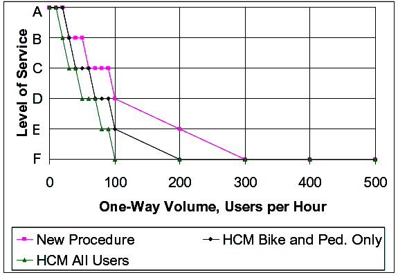
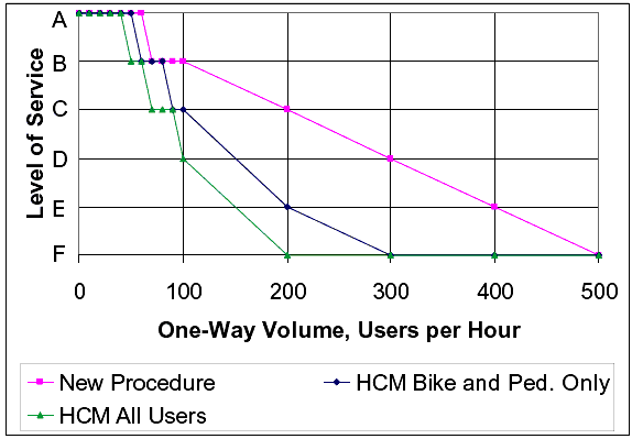
Before low-volumne adjustment. Comparison to HCM Method The recommended new procedure will return different LOS values than the LOS method in the 2000 HCM(4) for a given path. (4) Figure 29 shows a comparison of the recommended new method to the LOS method in the 2000 HCM for a 2.44-m- (8-ft-) wide (two-lane) path with no centerline, while figure 30 shows a comparison for a 3.66-m- (12-ft-) wide (three-lane) path with no centerline. In both comparisons, all other variables are at their average or default values. Both figures show LOS values for the 2000 HCM method in two different ways: (1) considering meetings and passings of bicycles and pedestrians only, and (2) considering meetings and passings of all path users by the test bicyclist.
Figure 29. Comparison of recommended new LOS procedure to 2000 HCM procedure for a 2.44-m- (8-ft-) wide (two-lane) path with no centerline.
Figures 29 and 30 both show that the new LOS procedure is more optimistic than the 2000 HCM method. The difference is typically one LOS, until the new procedure predicts LOS F; however, it was as high as three levels of service for 3.66-m- (12-ft-) wide paths at 200 one-way users per hour. The differences in LOS predictions probably result from the generally optimistic ratings of the video clips provided by the perception survey respondents.
Figure 30. Comparison of recommended new LOS procedure to 2000 HCM procedure for a 3.66-m-(12-ft-) wide (three-lane) Path with no centerline.
APPLYING THE MODELThe LOS procedure is applicable to a variety of trail planning and design problems related to crowding and accommodating diverse user groups. It is especially useful for trail planning and design tasks that need to augment qualitative criteria with quantitative measures in order to strengthen the basis for making trail design decisions. To enable the model to be easily used by practitioners, it has been programmed into a spreadsheet tool. This tool is called the Shared-Use Path Level of Service (SUPLOS) Calculator and it accompanies this report. This section helps the reader understand how to apply this tool effectively and to generate results that are appropriate for the particular problem at hand. To make the best use of the Calculator, it is important to understand the limits of its application, and how contextual factors should be considered when collecting or structuring the input data. Link Analysis The LOS procedure is a link analysis tool. It is designed to provide an LOS evaluation for a particular link or segment of a linear trail. It is not designed to evaluate trail/roadway intersections, rest stops, or trailheads. In general, segment length is not a limiting factor in selecting a link for analysis. The key to determining how much trail can be evaluated with one calculation is whether or not the trail conditions and use characteristics remain the same over the entire length that has been selected. However, because of the distance assumptions used in the model, trail segments under 0.4 km (0.25 mi) are not recommended for analysis. Moreover, because typical trip distances for some trail users are limited, and user turnback rates will begin to undermine the accuracy of the volume and mode-split data on longer segments, 3.2 or 4.8 km (2 or 3 mi) is a recommended maximum segment length. Each practitioner needs to exercise professional judgment in making these decisions. To assist in that effort, the following list of conditions and characteristics should remain roughly the same over the entire distance of trail that is being considered as one link (segment):
If any of these characteristics change significantly over the length of a trail segment, it is recommended that the segment be divided into one or more links using road crossings, access points, or other locations where characteristics change as endpoints for the smaller segments. Moreover, when considering establishing a trail volume and user mix profile for a single segment that is longer than 1.6 km (1 mi), based on counts taken in only one location, it is important to determine if turnback rates for pedestrians or for other users might be significant enough to affect the accuracy of these data for the sections of the segment that are farthest from the data collection point. In other words, if users often turn around partway through a segment, a single count may not represent the whole segment very well. As with any model, the quality and accuracy of the output can be no better than that of the inputs. It is understood that the quality and accuracy of input data will vary for each user of the tool. Moreover, each user and/or situation does not demand a uniform level of accuracy to produce a useful result. For these and other reasons, professional judgment is critical in determining what level of accuracy is required for the data to be used in any particular application. In most situations, slight variations in data may not affect LOS scores significantly, and the tool itself can be used to test variations in data and to determine what impact they do have on LOS results. The LOS procedure does not factor in the potential delay and other impacts of stop signs, signalized road crossings, or other grade crossings that interrupt the flow of trail traffic. The model is designed to generate LOS scores for trail segments of 0.40 km (0.25 mi) or longer, with no flow interruptions. If LOS is desired for a length of trail that includes these types of interruptions, it should be segmented at these locations and, if possible, separate volume and mode-split data should be developed for each segment. Segments shorter than 0.40 km (0.25 mi) are generally dominated by the stop signs or signals at the ends; consequently, a segment LOS would not normally be appropriate for those places. Data Requirements Only four data inputs are needed to generate an LOS estimate: (1) trail width, (2) presence of a centerline, (3) one-way user volume, and (4) mode split. The following discussion of data requirements is provided to help readers apply the tool correctly and effectively to their unique situations. Trail Width Trail width should be measured in feet. Widths may be entered in half-foot increments (i.e., 8.0, 8.5, 9.0, etc.) (1 ft = 0.305 m). The procedure was calibrated on data from trails that had widths between 2.4 and 6.1 m (8 and 20 ft). Widths greater or less than these amounts will produce LOS outputs; however, the model is not designed to address widths outside of the 2.4- to 6.1-m (8- to 20-ft) range. Centerline Centerline is a "yes/no" input to be based on the existing striping pattern of each segment or the proposed striping pattern for an unbuilt trail. Trail User Volume
The volume data needed for the procedure can be provided in one of three ways, depending on how the tool is being applied: 1)By using actual volume counts collected on an existing trail, 2) or By developing projected user volumes, such as for an unbuilt trail, where LOS calculations will be used to aid in the trail planning and design process. Whether volume data are developed from estimates or actual counts, they should be structured, or restructured, in the following ways:
Mode Split Mode split is expressed as a percentage of one-way trail users per hour.The model provides the opportunity to input a mode-split percentage for up to five different modes: adult bicyclists, pedestrians, joggers, inline skaters, and child bicyclists. In the calculation tool, mode-split inputs can be round numbers or precise numbers using one decimal place, and they need to add up to 100 percent exactly. Zero is an acceptable entry for any mode. Given the entire set of user types that are found on shared-use paths, these five categories were developed based on the actual users that were observed on the 15 study trails. Other users, such as push scooters, electric scooters (used by disabled persons), wheelchairs, etc., may be present or expected on trails where this tool is applied. If the mode-split data being used for the test trail segment include a breakout of user percentages in categories other than the five used by the Calculator, add that percentage to whichever one of the five modes has the closest corresponding travel speed. Average travel speeds by mode for each of the five modes listed above were presented in chapter 5, and are also in the User’s Guide. If actual mode splits are not known and estimates need to be developed, users can:
On many trails, user volumes and mixes will vary considerably along different segments of the facility. When more accurate LOS scores are desired, trail segmenting should take these variations into account. The following is a list of spatial and behavioral factors that can generate significant volume and mode-split fluctuations, and which can be used to guide segmentation:
Additionally, when new user counts are planned, these factors may be used to inform the location, frequency, and timing of the counts. When volume and mode-split estimates are being used for model inputs, these factors may be used to make adjustments to the estimates to increase the accuracy. Effects of Temporal Factors Temporal factors (e.g., season of the year, day of the week, and time of day) may be the most significant factors affecting trail user volumes. Therefore, any LOS estimate applies only to the timeframes in which the volume data counts were taken. In most cases, trail analysts seek to understand trail operations under fully loaded conditions. When this is the case, the volume data to be used in the Calculator should reflect those conditions. The volume data should be gathered during (or adjusted to reflect) the typical highest use times. The exact number and duration of user counts that are needed to fully describe fully loaded conditions may vary from case to case, depending on the level of detail desired for the volume profile and on how the resulting LOS score is to be used. To be consistent with the data collection methods used on the 15 trails studied in this project and to ensure some statistical stability in the results, at least three 1-h counts are recommended for each trail segment evaluated. Assuming that the purpose of the LOS score is to determine whether, and how, to improve service during high-use periods, counts should be taken during the high-use season, on high-use days, at high-use times of the day. In some cases, the crux of a trail manager's problem may center as much around determining the duration or extent of high-use periods as it does around determining how bad levels of service get during high-use times. In other words, if poor levels of service are only experienced a few weekends a year, or for an hour or two on a weekend day, it may be more tolerable than if a trail is crowded all day long throughout the spring, summer, and fall. In this way, the duration of time over which a certain LOS applies may be as important to know as the LOS score itself. In these cases, the volume data that are used in the Calculator will need to be more extensive and reflect greater temporal diversity. Some users of this tool may seek an LOS evaluation for a more specific purpose, such as to determine what the LOS is for bicycle commuters during the afternoon peak. In such a case, the data would need to be gathered on weekdays, during the season(s) that generate the highest commuting rates, and would focus on the particular afternoon hours when bicyclists are present on the trail segments in question. Assumptions and Default Values The following are the key assumptions and default values built into the Shared-Use Path LOS Calculator. These are generally based on average values from the data we collected during this project on 15 representative trails scattered across the United States. Users with significant departures from these values can change them in the Calculator. Directional Split The Calculator assumes a 50/50 directional split. User Speed The Calculator uses the average speeds and standard deviations for each user group, as shown in chapter 5. The default speed for the test bicyclist is 20.61 km/h (12.8 mi/h), the same speed as that of the average bicyclist. Peak-hour Factor The Calculator uses a default PHF of 0.85. This factor was calculated using the data collected on the study trails and was based on the peak 15 min, as is the custom in the HCM. The model applies the PHF of 0.85 to the one-way, per hour, user volume, which results in a volume boost of 17.6 percent. This factor ensures that the model results are responsive to the typical peak flow conditions that are found on trails. Number of Lanes This and other trail research has found that bicyclists on trails tend to operate in distinct lanes, whether or not the lanes are indicated on the trail surface with striping. Typical patterns include two-lane, three-lane, and four-lane operations:
Because there are no existing universal standards that correlate trail width with lane operations, this study assumed the following for the LOS procedure:
These widths roughly correlate with the AASHTO Bicycle Facility Design Guide's recommended 1.22-m (4-ft) minimum allocation of space for safe bicycle operation.(1) These widths also match what the research team generally observed during its operational data collection effort on 15 trails across the United States. Lane configuration matters only in the calculation of the delayed passing factor. The Calculator automatically determines the correct lane configuration to be used based on trail width. The delayed passing factor is computed differently for each of the three possible lane configurations, using the overall trail volume, mode split, and average travel speeds, to calculate the probability of encountering delay in a passing maneuver:
LOS LOOKUP TABLESAppendix C of the User's Guide includes a series of lookup tables that provide LOS estimates for a variety of combinations of volume, mode split, and trail width, based on default values for other variables. Instructions for Using the LOS Calculator The Shared-Use Path Level of Service Calculator is provided in the form of a spreadsheet. It has the complete LOS model programmed into it, and provides a one-page, user-friendly interface (worksheet) that allows the user to analyze up to five data sets at a time. The Calculator requires only four inputs to generate an LOS estimate from the bicyclist perspective–trail width, presence of a centerline, trail user volume, and mode split–for up to five user types (adult bicyclists, pedestrians, joggers, inline skaters, and child bicyclists). The Shared-Use Path Level of Service Calculator should be opened in Excel. ";Enable Macros"should be selected in the first dialogue box. If it is not already selected, the SUP_LOS_ Calculator tab at the bottom of the window should be selected. This will open the Calculator worksheet. Before beginning the data entry process, review the previous discussion about data requirements. Based on that discussion, assemble the data necessary to conduct the analysis.
Once all of the numeric inputs are provided, columns 11 and 12 will calculate the level of service score and will provide the level of service grade, automatically. In the upper right-hand corner of the spreadsheet, a scale is provided that correlates scores with the grade. In general, grades A through C can be considered above-average levels of service, and grades D through F as below-average levels of service. Once the LOS has been computed, the whole sheet may be copied or printed to a word or spreadsheet file to create a permanent record of these cases and results. Once the information has been pasted into a new file, revision of model calculations will not be possible in that new document. The results may be printed using the regular print commands to print directly from Excel, or by printing the file to which copies have been saved. By copying and saving the results to another file, the Calculator can be used over and over again without losing the results of previous scenarios. For convenience, the Calculator worksheet has been designed with a separate one-click button to reset the default mode split for each row. Implications for Trail Design The central findings of this study have important implications for trail design. The following is a list of key findings that can be used to inform design choices:
Trail Width The LOS procedure provides strong support for the standard trail-width guidance provided in the AASHTO Guide for the Development of Bicycle Facilities.(1) Trails that are 2.4 m (8 ft), which AASHTO recommends only in "rare instances," were found to have poor levels of service, except at very low volumes, or with user mixes that included few pedestrians and joggers. The findings of this research supports AASHTO's(1) minimum "recommended paved width for a two-directional shared-use path of 10 feet [3 m]." The procedure shows that widths of 3.35 to 4.57 m (11 to 15 ft) provide improved levels of service for higher volumes and more balanced user mixes. This is also consistent with AASHTO recommendations that, "under certain conditions, it may be necessary or desirable to increase the width of a shared-use path to 12 ft [3.6 m], or even 14 ft [4.2 m], due to substantial use by bicycles, joggers, skaters, and pedestrians."(1) Trails of 3.35 to 4.57 m (11 to 15 ft) are wide enough to operate as three-lane paths. The increased passing capacity provided by a trail that operates as three lanes improves LOS and increases the trail's ability to absorb higher volumes and more diverse mode splits without severely degrading service. The implications for designers of these results regarding trail width include:
Centerline Striping A striped centerline was found to have a strong impact on the bicyclist's perception of freedom to maneuver. This finding appears to support the intent of trail designers in providing a centerline, which is to clearly delineate two opposing travel lanes. A centerline reinforces the idea that to pass a slower moving user, the bicyclist may need to use the travel lane of opposing trail users, and should pass only when the opposing lane is open. This research found that the presence of a centerline stripe results in a significant reduction in the LOS score. It appears that bicyclists felt less comfortable making a same-direction passing movement when a centerline stripe was present. While this finding might appear initially to mean that a centerline should not be used, it is important to note that there may be other valid safety reasons for providing a centerline stripe, particularly on crowded trails, on curves with limited sight distance, and in other appropriate circumstances. Only two trails in this study were striped with more than two travel lanes. The Pinellas Trail near Saint Petersburg, FL, was striped as a three-lane trail, one in each direction for bicycles and skaters, and one lane for pedestrians. The Lakefront Trail in Chicago, IL, was striped as four lanes, two in each direction. These two examples did not represent a sufficient number of study trails to fully assess the impact of multi-lane striping patterns on LOS. However, the LOS procedure is based on the idea that having sufficient trail width for a four-lane operation (a minimum of 4.57 m (15 ft)) increases the ability of bicyclists to pass slower moving users without encountering blockage from trail users in the opposing lanes. Multiple Treadways A number of shared-use trails have been designed with two treadways in the same trail corridor. Often, one is paved and the other is a soft surface. Frequently, one of the treadways is provided for exclusive use by one or two trail user groups, or user restrictions are imposed on both paths in an effort to segregate users. Given the impact of user mix on bicyclist LOS, a multiple treadway design that effectively reduces the number of pedestrians and joggers mixing with bicyclists will have significant LOS benefits for the treadway used by bicyclists and skaters. This study did not address compliance with use restrictions–an issue that is often raised by trail managers as a problem when separate treadways are provided. Trail Operations and Management While this study did not examine issues related to trail operations and management, the framework of the tool may lend itself to applications in this area. Ideas include using LOS grades in warrants for warning or trail etiquette signs. These trail etiquette signs address sharing of the treadway or use of designated passing protocols. The LOS procedure may also be useful in setting trail speed limits or in establishing other advisory or regulatory protocols that will increase user safety and will moderate user conflicts. CASE STUDIESThe User's Guide contains several case studies posing typical problems facing designers and showing how the LOS procedure can help provide solutions to those problems.
FHWA-HRT-05-137 |
|||||||||||||||||||||||||||||||||||||||||||||||||||||||||||||||||||||||||||||||||||||||||||||||||||||||||||||||||||||||||||||||||||||||||||||||||||||||||||||||||||||||||||||||||||||||||||||||||||||||||||||||||||||||||||||||||||||||||||||||||||||||||||||||||||||||||||||||||||||||||||||||||||||||||||||||||||||||||||||||||||||||||||||||||||||||||||||||||||||||||||||||||||||||||||||||||||||||||||||||||||||||||||||||||||||||||||||||||||||||||||||||||||||||||||||||||||||||||||||||||||||||||||||||||||||||||||||||||||||||||||||||||||||||||||||||||||||||||||||||||||||||||||||||||||||||||||||||||||||||||||||||||||||||||||||||||||||||||||||||||