
The Federal Highway Administration (FHWA) Office of Planning, Environment and Realty's (HEP) Surface Transportation Environment and Planning Cooperative Research Program (STEP) ended on September 30, 2012. For current HEP research information, please see HEP's research web site.
The Federal Highway Administration's (FHWA) Surface Transportation Environment and Planning Cooperative Research Program (STEP) A Federal Research Program - Conducting Research That Links to Practice |
 |
FHWA-HEP-10-036
Also available as Adobe PDF for printing. fy09highlights.pdf. (479 KB)
STEP is a federally administered research effort to help improve the understanding of the relationship between surface transportation, planning, and the environment. STEP stakeholder input is used to help identify and prioritize STEP research topics. During FY2009 FHWA's STEP funded 67 studies, events and reports. This document provides an overview of STEP research activities that made significant progress during FY2009. For more information on STEP contact: Felicia Young www.fhwa.dot.gov/hep/step/index.cfm Stakeholders should contact individual STEP emphasis area contacts to discuss the status of research in a specific emphasis area. |

Air Quality and Climate Change Research, Outreach, and Communication accomplishments included development of the FHWA Highways and Climate Change website www.fhwa.dot.gov/environment/climate_change/ and brochure, the 10 Simple Steps to Reducing Climate Change flyer, the U.S. DOT Transportation and Climate Change Clearinghouse website http://climate.dot.gov/as well as research on air quality health effects and highway proximity.
Through the Carbon Sequestration Pilot Program, FHWA worked closely with the New Mexico and Minnesota Departments of Transportation to develop a decision-support tool that evaluates the potential for large-scale sequestration in these states and others. Another accomplishment included development of national-level estimates of right-of-way acreage and the percentages of these areas that are available for sequestration activities. http://climate.dot.gov/
In December 2009, EPA released the final version of the Motor Vehicle Emissions Simulator (MOVES) Model called MOVES2010. For more information visit http://www3.epa.gov/otaq/models/moves/index.htm. During 2009 several research initiatives took place to enhance, fully utilize and help implement the new model. These on-going research efforts are summarized in the following paragraphs.
Participate in STEP Research Stakeholders can develop and submit feedback on suggested lines of research that are related to the proposed STEP research priorities. http://knowledge.fhwa.dot.gov/cops/step.nsf/home/ (Link no longer active 5/12) |
Moving Cooler: An Analysis of Transportation Strategies for Reducing Greenhouse Gas Emissions provided information on the greenhouse gas (GHG) reduction potential of approximately 50 strategies related to travel behavior and system efficiency. The study also estimated costs and cost savings from these strategies, the GHG reduction from bundles of related strategies, and the equity impact of these measures. Sponsors included The U.S. Federal Transit Administration (FTA), the U.S. Environmental Protection Agency (EPA), the Intelligent Transportation Society of America and the American Public Transportation Association to name a few. The study can be found at http://www.movingcooler.com/
The Congestion Mitigation and Air Quality (CMAQ) Evaluation and Assessment Study, Phase II assessed a cross-section of CMAQ-funded projects and conducted seven field studies of state and local CMAQ practices. The study responds to the SAFETEA-LU requirement to ensure effective implementation of the CMAQ program. The report also provides observations from the field about challenges and opportunities for improvement in CMAQ program implementation. Phase I of the study, which analyzed 67 CMAQ-funded projects, was completed in 2008. Phase II can be found at https://www.fhwa.dot.gov/environment/air_quality/cmaq/research/safetea-lu_phase_2/index.cfm

A report on the Wildlife Vehicle Collision (WVC) Reduction Study was published while the WVC Best Practices Manual was completed.
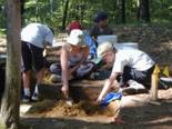
The Deer-Vehicle Crash Information and Research (DVCIR) Center is developing methods to identify and prioritize Deer-Vehicle Crash (DVC) locations of concern. This project will document current methods used by State DOTs to identify DVC "hot spots," evaluate these methods, and recommend a set of best practices for advancing DVC-related safety management systems. This evaluation will focus on the nine states that contribute funds to the DVC Information and Research Center and 15 additional states. These accomplishments are a result of STEP and DVCIR Pooled Funds. http://www.deercrash.com/pooledfund.htm
To Support Peer and Research Exchange at Conferences, Workshops, and Technical Panels funding support was provided to develop or host the following conferences: 2010 Weeds Across Borders Conference; 2009 National Wetlands Award Program; 2009 Natural Areas Association Symposium; 2009 National Mitigation and Ecosystem Banking Conference; and 2009 Transportation Liaison Peer Exchange Workshop at the International Conference on Ecology and Transportation (ICOET).
 A Workshop on Communicating, Consulting, and Cooperating with Indian Tribes on State Transportation Projects: The Role of the National Environmental Policy Act (NEPA) provided practical assistance on multicultural approaches to intergovernmental communication, consultation, and cooperation on transportation. Attendees gathered to improve the understanding of the complex relationship between surface transportation, environment, and planning. Participants included 11 federally recognized Tribes as well as staff from FHWA, State DOTs, the Bureau of Indian Affairs, and other Federal agencies. The workshop took place September 29-30, 2009 and was co-sponsored by the Minnesota DOT.
A Peer Exchange for State DOT and State Historic Preservation Office (SHPO) Liaisons was held during the 2009 Summer Meeting of the Transportation Research Board (TRB) ADC50 Committee on Archeology and Historic Preservation. Ideas presented included development of an online toolkit; webinars geared to SHPOs, technology transfer among agencies, and peer exchanges to maintain dialogue on seeking common ground and consistency on key issues. The meeting was held on July 19-22, 2009 in Sheridan, Wyoming.
 Through Outreach and Best Practices on Bicycle and Pedestrian Issues, FHWA in conjunction with AASHTO, conducted the International Scan on Pedestrian and Bicyclist Safety and Mobility. A summary report from the scan was published online and the full report will be completed.
Research efforts continued on the Nonmotorized Transportation Pilot Program (NTPP) to study how improve rates of walking and bicycling promote better health and a cleaner environment. The NTPP also continued to promote research to improved data and modeling for walking and bicycling trips through various types of data collection. For more information visit https://www.fhwa.dot.gov/environment/bicycle_pedestrian/ntpp/index.cfm

The FHWA Traffic Noise Model (TNM) Version 3.0.development continued. Testing and validation will be ongoing in FY2010. Additional information can be found at
https://www.fhwa.dot.gov/environment/noise/traffic_noise_model/
 Support of Stakeholder and Partner Outreach and Informational Dissemination Programs included co-sponsorship of two national meetings which were attended by right-of-way (ROW) and outdoor advertising control professionals, 12 Federal agencies, and 24 State agencies. Outreach also included sponsorship of the Real Estate Community of Practice, which is available at https://collaboration.fhwa.dot.gov/dot/fhwa/rex/default.aspx.
A Right of Way (ROW) Competency Navigator Tool was developed to assist in identifying training resources and competency building tools for ROW and outdoor advertising control. The Navigator will further efforts to develop ROW professional competency. It will also serve as a resource for partners as well as internal and external customers in defining and developing ROW core competencies. /real_estate/rcb_navigator/
 Advancing Innovations in FHWA's Environmental Review Process Study monitored and documented the impact of the SAFETEA-LU environmental review process. An internal report on the effectiveness of SAFETEA-LU Section 6002 environmental provisions was compiled.
The State Transportation Liaison Funded Positions Study was completed. The report is available at: https://www.environment.fhwa.dot.gov/env_initiatives/initiatives_home.aspx
Leveraging FHWA and State DOT Environmental Research Projects included providing $100,000 in support of the National Cooperative Highway Research Program (NCHRP) Project 25-33, Evaluation of Methodologies for Visual Impact Assessments (VIA). Objectives of this research include evaluating State DOT VIA procedures, methods, and practices that satisfy or exceed NEPA and other requirements, document proven successful methods, promising new developments and lessons learned. For more information on the Domestic Scan Program visit http://144.171.11.40/cmsfeed/TRBNetProjectDisplay.asp?ProjectID=2738
KEY FACT STEP funds can be awarded to state/local governments, metropolitan planning organizations, universities, federal agencies, and the private sector. |
A Domestic Scan on Best Practices in Project Delivery Management, NCHRP20-68A Scan 07-01, brought together six states to share innovations in project management, performance measures, contracting practices and community involvement. FHWA provided facilities to support a series of five webinars on the findings. Results can be found at http://www.trb.org/NotesDocs/2068A_Prospectus.pdf
The Planning and Environmental Linkages (PEL) initiatives included four "Linking Conservation and Transportation Planning" workshops and an environmental consultation peer exchange to showcase examples of how State DOTs and MPOs conduct consultations with resource agencies. In addition, three sessions of a web conference titled PEL 101 Webcast: The Tools for Adopting and Implementing a PEL Approach were held.
Eco-Logical: An Ecosystem Approach to Developing Transportation Infrastructure Projects in a Changing Environment paper was developed as an output of the Eco-Logicalgrant program and the interagency working group. The paper and presentation focused on three case studies to understand how the Eco-Logical approach is working in practice. The paper is available at https://www.environment.fhwa.dot.gov/env_initiatives/eco-logical/report/ecological.pdf
A Guide to Measuring Progress in Linking Transportation Planning and Environmental Analysis paper was developed to assist State DOTs and MPOs in developing programs to measure progress toward linking transportation planning and environmental analysis. The guide outlines a framework for establishing measures that transportation agencies can utilize to develop their own measurement programs. The guide is available at: https://www.environment.fhwa.dot.gov/env_initiatives/pel/meas_progress.aspx.

The Context Sensitive Solutions (CSS) Clearinghouse launched its new Professional Seminar Series and hosted three webinars on sustainable stormwater management, complete streets, and livability. A fourth webinar was conducted to unveil the new Guide to Building CSS Knowledge and Skills for Successful Project Delivery (the "CSS Training Guide"). https://www.fhwa.dot.gov/planning/css/
The CSS National Dialog was launched. A 34-member steering committee comprised of a wide range of partner agencies, State Departments of Transportation (DOTs), and other organizations committed to CSS principle
was formed to guide the National Dialog. The project serves as a catalyst for exchanging ideas and will build momentum for wider implementation of CSS in the transportation industry. http://www.cssnationaldialog.org/
The CSS National Dialog Solicited Best Practices May through July 2009. This effort resulted in 92 submissions that will be shared with transportation professionals and stakeholders via the CSS Clearinghouse and a series of one-day National Dialog workshops. The workshops which will be held in various locations nationwide will highlight several CSS best practices. http://www.cssnationaldialog.org/schedule.asp
The CSS Primer https://www.fhwa.dot.gov/planning/css/resources/cssprimer/ was finalized and disseminated. The primer contains fundamental information about the definition, principles, benefits, and application of CSS at multiple jurisdictional and procedural levels. The document is intended as an outreach and educational tool for broad distribution at conferences, training events, and other forums.
The Innovative Methods of Applying Analysis Tools in Planning for Operations project developed case studies with an executive brochure to promote the use of innovative tools as well as demonstrate and encourage innovation in the use of analysis methods for linking planning and operations. http://plan4operations.dot.gov/casestudies/analysis.htm

An Innovative Analysis workshop to encourage message delivery was developed. Four workshops will be scheduled for FY 2010. https://www.fhwa.dot.gov/resourcecenter/index.cfm
A Peer Exchange Workshop on Defining and Demonstrating Model Transportation Plans Incorporating Management and Operations (M&O) and Associated Safety Benefits was held with MPO stakeholders to assist in the development of an outline for a reference manual. A draft version of the manual was prepared. A second peer exchange workshop with the same stakeholders was conducted to review the draft manual. The draft reference manual is currently being finalized.
A final review of Advancing Planning For Operations: A Guidebook for an Objectives-Driven, Performance-Based Approach to Integrating Operations in Metropolitan Transportation Planning was completed. The guidebook can be found at http://www.ops.fhwa.dot.gov/publications/fhwahop10026/index.htm.

Making the Case for Transportation Safety-Ideas for Decision Makers compiled noteworthy practices on transportation safety. The noteworthy practices included 20 case studies regarding States, Tribal governments, MPOs, transit agencies, and other agency transportation safety initiatives. http://tris.trb.org/view.aspx?type=MO&id=872327
KEY FACT STEP funds are used to identify, address and reassess national research priorities for planning, environment and realty. |
A Primer on Safety Performance Measures and the Transportation Planning Process documented how to employ safety performance measures during the transportation planning process. The report outlines the benefits of using safety performance measures in planning, as well as basic information on these measures. Seven case studies highlighted the experience and application of States and MPOs in the development and use of safety performance measures. The report also included a high-level, step-by-step approach for developing safety performance measures and can be found at http://safety.fhwa.dot.gov/tsp/fhwahep09043/
NHI/National Transit Institute Transportation Safety Planning Course was updated to include SAFETEA-LU requirements on the State Highway Safety Plan and safety planning. Technical reviews and a pilot will be completed and the two-day course will be offered through the NHI website.
 Development of Freight Planning publications included a Guidebook for Engaging the Private Sector in Freight Transportation Planning; a Freight and Land Use Resource Guide/Handbook and related workshops; a Freight and the Environment Guidebook; and Freight and Air Quality Handbook.
The Building Capacity between Public and Private Sectors in the Freight Community effort and the National Association of Regional Councils (NARC) hosted two peer exchanges and a web-based freight summit meeting; developed a resource manual and identified possible performance measures for involving the private sector in freight planning.
A Building Planning Capacity Between Public and Private Sector Partners in the Freight Industry: A Resource Manual was completed.The document is available at http://ops.fhwa.dot.gov/freight/resources/current_news/news.cfm?ID=305.
 The Guide to Transportation Decisionmaking was updated. The guide describes how transportation decisions are made at the local, State, and national levels and provides resources to foster increased public involvement in transportation decision making processes. https://www.fhwa.dot.gov/planning/publications/transportation_decision_making/
Best Practices in Transportation Planning: Performance Measures, Environmental Mitigation, and Fiscal Constraint research is underway to examine the ways in which states and MPOs have responded to SAFETEA-LU requirements and to identify best practices in transportation planning, specifically in the areas of performance measures, environmental mitigation, long-range transportation planning, and fiscal constraint.
A Peer Exchange Executive Roundtable: Performance-Based Planning and Programming provided an opportunity for FHWA and its partners to develop a workable definition for performance-based planning and programming by framing a realistic, achievable performance-based planning and programming approach. http://rip.trb.org/browse/dproject.asp?n=24577
The Linking Land Use and Transportation Planning Toolkit was updated with current information about consensus, collaboration building, and development of outreach/information dissemination strategies. https://www.fhwa.dot.gov/planning/processes/land_use/i
The Tribal Transportation Planning Module Training Series provides modules for eight planning topics to assist transportation professionals to plan for capital, operating, and maintenance needs on Tribal lands. http://www.tribalplanning.fhwa.dot.gov/training_series.aspx

KEY FACT The proposed FY2011 STEP Implementation Strategy which outlines the likely research priorities for FY2011 is available for review. |
The U.S./Mexico Transportation Joint Working Committee (JWC) conducted border travel time studies to provide baseline information. These baseline data will be used to develop performance measures to evaluate the success of improvement projects, policies, and strategies. The San Diego Border Wait Time Study has been completed, while The El Paso Border Wait Time Study, Nogales Border Wait Time Study and Pharr Border Wait Time Study are underway.
Bottlenecks Study Phase II was conducted for Nogales, Arizona and Nogales, Sonora, Mexico. Two traffic studies for Nogales, Arizona, and Pharr, Texas were completed.
The Regional Border Master Plan along the U.S./Mexico border between California and Baja California was developed and is the first in a series of comprehensive transportation border master plans for the border regions. www.borderplanning.fhwa.dot.gov/mexico.asp
A Transportation Border Working Group "Border Glossary" website section was developed along with updates to the "Links" and "Library" sections of the website. Additionally an online inventory of land border crossings which included completed data entry for 120 land border crossings (including facilities and infrastructure projects) was developed to coordinate infrastructure investments along the border.
A Binational Border Wait Time Study with the USDOT, Transport Canada, CBP, and the Canadian Border Service Administration was conducted. This joint study defined a standard way to measure border wait time. Two pilots will be conducted.
The National Border Planning Activities project accomplishments included conducting a national conference titled "North American Freight Flow Conference: Understanding Changes and Improving Data Sources." in Irvine, California, with participation from U.S./Mexico and U.S./Canada transportation agencies. The conference examined ways to improve freight plans between the three countries. These activities were co-sponsored by the Transportation Research Board (TRB), the Bureau of National Statistics (BTS) and the Federal Motor Carrier Safety Administration (FMCSA). http://www.thetbwg.org/index.htm
 The Monitoring of Case Studies: Interstate and NHS Economic Development draft report was developed to highlight efforts to improve understanding of the economic development results of certain highway corridors. Research is being conducted in coordination with the Strategic Highway Research Program 2 (SHRP2) Project C03 (Interactions between Transportation Capacity, Economic Systems, and Land Use merged with Integrating Economic Considerations Project Development) and Project C11 (Development of Improved Economic Analysis Tools Based on Recommendations from Project C03).
The Travel Model Improvement Program (TMIP) outreach to the modeling community included the following:
Twelve regularly scheduled web seminars were held with an estimated total attendance of 1,975 for all of the webinars. The audience included federal, state, metropolitan planning organizations, local governments, academia and the private sector.
The past fiscal year marked the kickoff of the Virtual Mentoring and Technical Assistance Center (VMTSC). The VMTSC represents an effort by TMIP to expand the reach of the Mentoring Program by offering one-hour online virtual office sessions via the TMIP webconferencing system. Detailed descriptions of TMIP activities are available at https://www.fhwa.dot.gov/planning/tmip/.
TMIP Peer Review Program gives transportation planning agencies the opportunity to have their model reviewed by modeling experts from around the country. These experts make recommendations on how to proceed with model enhancements to ensure that the techniques being developed or implemented meet the current and future needs of the agency. TMIP supported four MPOs peer reviews in FY2009. Reports are available at http://https://www.fhwa.dot.gov/planning/tmip/resources/peer_review.
The Census Transportation Planning Package (CTPP) program is a coordinated project with AASHTO and the Census Bureau. Through this research four out of five profile sheets were prepared and are posted on the AASHTO webpage at http://ctpp.transportation.org/Pages/profiles.aspx. The remaining profile is being prepared by the Census Bureau. When completed, all materials will be converted to hypertext markup language and posted on the FHWA webpage.
 Two peer exchanges focused on geospatial technology applications in transportation, including bicycle/pedestrian applications and geospatial applications used in an ecosystem approach to develop infrastructure projects. Summary reports of the peer exchanges were also completed and are available at www.gis.fhwa.dot.gov. Three remaining peer exchanges are planned.
Four quarterly Webcasts on the Application of Geospatial Information Systems (GIS) and Spatial Information were held. The topics included Enterprise GIS (by Florida DOT); Multi-level linear referencing systems (by Iowa DOT); The
evolution of the Maryland State Highway Administration's (SHA) road centerline and One Maryland, One Map initiative (by Maryland SHA and the Maryland Governor's Office); and Multi-level linear referencing systems and the Event GeoLocator application (by Nevada DOT).
A Peer Exchange on Applications of Three Dimensional (3D)/GIS Visualization was held in Raleigh, North Carolina July 8-9, 2009. The peer exchange was hosted by the North Carolina DOT with representatives from North Carolina as well as the Baltimore Metropolitan Council, CalTrans, Minnesota DOT, New York State DOT, Volusia County MPO, and Washington State DOT. A summary report of the peer exchange can be found at http://www.gis.fhwa.dot.gov/reports.asp

