

Archived: TRB Mid-Year Meeting Symposium On The Effects of Abandoned Underground Mines on Transportation Facilities
Abandoned Underground Mine Inventory and Risk Assessment
L. Rick Ruegsegger, P.E.1 and Thomas E. Lefchik, P.E.2
Abstract
On March 4, 1995, the eastbound driving lane of Interstate Route I-70 in Guernsey County, Ohio collapsed due to subsidence related to abandoned underground mines. The Ohio Department of Transportation ( ODOT ) since that time has undertaken a number of site investigations and three notable mine remediation projects on interstate highways in an effort to prevent such subsidence from occurring again in the roadway. The remediation methods have consisted of the grouting of mine voids, construction of land bridges, and the removal and replacement of overburden.
As a result of the March, 1995 collapse of I-70, the ODOT Abandoned Underground Mine Inventory and Risk Assessment process was conceived. This process is a proactive response to the need to locate and assess the risk of all mapped or otherwise identified roadway sites beneath which abandoned underground mines exist. The process, which is documented in an ODOT technical manual, is comprised four basic activities: 1) the establishment of an inventory of all roadway sites beneath which abandoned underground mines may exist; 2) the assessment of the risk to the safety of the traveling public which each site represents; 3) the remediation of sites, if necessary, and; 4) the permanent monitoring of sites.
Introduction
The eastbound driving lane of Interstate Route I-70 in Guernsey County, Ohio collapsed on March 4, 1995 due to subsidence related to abandoned underground mines. The Ohio Department of Transportation (ODOT) recognized that similar sites may exist beneath interstate highways and other roadways. Consequently, an effort was undertaken to develop and implement an Abandoned Underground Mine Inventory and Risk Assessment process. The process is documented in an ODOT technical manual (ODOT, 1998) and an FHWA publication (FHWA, 1999) which can be purchased by the general public. This process is a proactive response to the need to locate and assess the risk of all mapped or otherwise identified roadway sites beneath which abandoned underground mines exist.
The overall purpose of this inventory and risk assessment effort is to enhance the safety of the traveling public. The possibility of sudden abandoned underground mine subsidence in roadways, which could result in fatalities or bodily injuries, will be minimized. The process will: 1) reduce liability by identifying and prioritizing high risk sites, permitting a systematic response; 2) provide a means to budget funds for the remediation of sites to a predetermined risk level, and; 3) create a valuable informational resource available to all staff. This database will be a tool utilized to avoid or anticipate potentially unstable underground conditions during project planning, design, construction, and maintenance.
The first reported production of coal in Ohio was in 1800, three years before the state's entrance into the Union (Crowell, 1995). Since that time, varying amounts and forms of recoverable resource mining have occurred in Ohio. The age of the majority of the abandoned underground mines associated with these sites ranges from 50 to 150 years. The Ohio Department of Natural Resources, Division of Geological Survey has detailed abandonment maps for approximately 4,200 underground mines. In addition to those mines, the Division of Geological Survey estimates there are approximately 2,000 mines in Ohio for which no detailed maps of the mine workings are available. (Crowell, 1997)
The development of an Abandoned Underground Mine Inventory and Risk Assessment process for all state roadway sites in Ohio is a formidable task. As many as 1000 of such roadway sites may exist in Ohio. These roadway sites represent an existing, undefined and yet possibly significant risk to the safety of the traveling public. The Ohio counties in which there are available abandoned underground mine maps are included in ten of the twelve ODOT Districts.
No matter how diligently ODOT performs this lengthy inventory effort, some areas of abandoned underground mining will not be identified or located due to the lack of documentation or the poor quality of the available information. However, unanticipated roadway problems related to the presence of abandoned underground mines beneath the roadway will be kept to a minimum through the implementation of the process.
Key aspects of this inventory process are information sharing, communication, and cooperative problem solving with various State and Federal governmental agencies. These agencies include: the Ohio Department of Natural Resources, Divisions of Mines and Reclamation, Geological Survey and Water; the Ohio Environmental Protection Agency, Division of Drinking and Ground Waters; the Ohio Mine Subsidence Insurance Underwriting Association; the Federal Highway Administration; and the U.S. Department of Interior, Office of Surface Mining. The Ohio Department of Natural Resources, Divisions of Mining and Reclamation, and Geological Survey are providing cooperative technical assistance in support of the ODOT effort to establish the inventory of roadway locations under which abandoned underground mines exist.
The process was created and documented in a technical manual by an ODOT team which worked together on the project from 1995 to 1998. During this time period, ODOT also had to be responsive to detected possible abandoned mine subsidence problems. Several roadway sites were investigated and remediated during this period in the interest of preventing subsidence similar to the I-70 collapse from occurring again during process development.
Remedial Response During Process Development
Including the repair of the I-70 collapse site, three notable mine remediation projects on interstate highways were undertaken by ODOT. These projects were undertaken in response to roadway conditions suggesting mine subsidence activity. The remediation methods consisted of the grouting of mine voids, construction of land bridges, and the removal and replacement of overburden.
I-70:
The first mine remediation project on an interstate highway was undertaken on I-70 in Guernsey County, in eastern Ohio between March and July, 1995. Investigations by ODOT revealed possible mine-related subsidence activity and a consultant was retained for the purposes of project investigation, design, and construction management assistance. Unfortunately, in spite of monitoring of the site by ODOT every four hours, a thirteen foot diameter by ten foot deep hole suddenly opened in the eastbound travel lane at I-70. Three cars and a truck were damaged when they encountered this hole. Fortunately, no critical injuries resulted from this event.
The length of the project area was approximately 2,000 linear feet. The remedial effort involved the air rotary drilling of approximately 1,800 boreholes down to the mined coal seam interval, at a depth of approximately 65 feet. The average depth of the soil-bedrock interface was approximately 47 feet. The drilled boreholes were cased to bedrock to allow for tremie grouting of the lower lying mine-related voids. Approximately 18,000 cubic yards to flyash grout was tremied into subsurface void areas. Two land bridges, having lengths of 700 linear feet and 110 linear feet, were constructed over areas where the drilling and grouting program encountered high concentrations of caved and broken materials in the mined interval. The approximate cost of this project, including land bridge installations and pavement replacement, was approximately $3.6 million.
I-70 and I-77 Interchange:
The second mine remediation project on an interstate highway was undertaken in the Interchange of I-70 and I-77 in Guernsey County, in eastern Ohio between June and November, 1995. The site investigations and design for this project were performed by a team of engineering and construction staff which had originally formed in response to the original remediation project on I-70.
The office and field investigations of this site revealed the need to perform remediation work on portions of all mainline lanes and all ramp lanes with the exception of one ramp. They also revealed large voids a few feet beneath the pavement of a ramp. This necessitated immediate closure and remediation of this ramp while project investigations and design were completed.
The project entailed approximately 5.7 lane-miles of roadway, including the work on all mainline lanes and ramps. The remedial effort involved the air rotary drilling of approximately 2,600 boreholes down to the mined coal seam interval, at a depth ranging from 10 to 100 feet. Approximately 80,000 cubic yards to flyash grout were tremied into subsurface void areas. The approximate cost of this project was approximately $4.7 million.
I-470:
The third mine remediation project on an interstate highway was undertaken on I-470 in Belmont County, in extreme eastern Ohio between September and December, 1996. This project area included 1700 linear feet of interstate highway just west of the Ohio River near Wheeling, West Virginia. This project area had exhibited pothole subsidence in ditch and graded slope locations. It was designated by ODOT as a study area for the field testing of investigative techniques and site evaluation techniques being drafted for the manual.
Site investigation methods included ground penetrating radar, profilometer, ground survey, falling weight deflectometer, drilling, and borehole camera. These investigations revealed that overburden rock was extremely fractured. A large void was found to be migrating toward the surface. Consequently, it was decided to immediately close the roadway and remediate the site by excavation to the base of the mined coal seam and then backfilling.
The resulting mine remediation project involved approximately 400,000 total cubic yards of roadway excavation, new pavement, signs, lights, guardrail, pavement striping and revegetation. The project was completed in approximately 14 weeks. The approximate cost of this project was $3 million.
Other Sites:
Several other state highways have since been investigated. Two of these sites were remediated by drilling and grouting and one site was remediated by excavation and backfilling.
Long Term Process Approach
This process is the most logical and practical approach to responsibly monitor the safety of the roadways relative to abandoned underground mines. Due to the large number of sites, it is not logistically or financially responsible to commit limited forces and funding to random investigation and remediation of sites. A large portion of the process is the gathering and reviewing of existing information to initially identify and evaluate the risk of sites. A cornerstone of the inventory and risk assessment process is the concept of "being as informed as possible" before ever committing limited resources to individual sites for priority investigations and, if necessary, remediation. The sites which pose the greatest threat to public safety will be assessed as having the highest priority for priority site investigations, and remediation if required.
The process is comprised of four basic activities: 1) the establishment of an inventory of all roadway sites beneath which abandoned underground mines may exist; 2) the assessment of the risk to the safety of the traveling public which each site represents; 3) the remediation of sites, if necessary, and; 4) the permanent monitoring of sites. A process flow chart is presented as Figure 1.
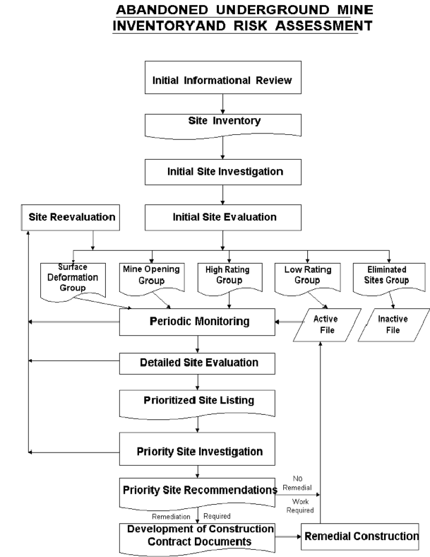
Figure 1.Flow chart |
Establishment of an Inventory of Sites
The first step in this process is establishing an Inventory of Sites. An initial comprehensive site listing is established based on: 1) review of available records; 2) field report forms; 3) follow-up investigation of field report forms, and 4) field visits to all identified potential sites
The inventory portion of this process involves collection and review of available records for abandoned underground mines within the inventory area. This information is gathered from a variety of sources. The primary source of available, pertinent information is the Ohio Department of Natural Resources, Division of Geological Survey. Field Report forms are also provided to roadway maintenance and construction personnel for the purpose of gathering field information which might reflect mine-related problems beneath the roadway. Staff who are involved with the inventory process and are familiar with signs of mine-related problems conduct a follow-up investigation of each Field Report form received.
Next, all sites are visited and certain field information is recorded. The goal is to obtain enough information from one site visit to allow for the risk assessment of the site through Initial and Detailed Site Evaluations. Following this site visit, all sites which are not eliminated by field findings are subject to periodic monitoring.
Risk Assessment
The risk assessment portion of the process involves three levels of site evaluation: 1) Initial Site Evaluation; 2) Detailed Site Evaluation, and; 3) Priority Site Investigations and Recommendations. The risk assessment criteria used for all levels of site evaluation take into account two basic factors: 1) the existing site conditions and; 2) the level of the traveling public's exposure to those conditions.
The Initial Site Evaluation and Detailed Site Evaluation both apply weighted criteria to existing information and information obtained from one site visit. The Initial Site Evaluation subdivides the initial inventory listing of sites into 5 risk assessment site groups. The Detailed Site Evaluation risk assessment is then performed on each of the three highest risk site groups in the order of the group priority level of risk. The result of the Detailed Site Evaluation process is a prioritized listing of the sites within each of the three highest risk site groups.
Initial Site Evaluation
The Initial Site Evaluation process subdivides the entire inventory of sites into five risk-assessment site groups. This subdivision of the site inventory is accomplished by use of a standard site evaluation form to establish a numerical risk assessment rating for each site. Sites exhibiting surface deformation, containing mine shafts, or documented as posing no threat to roadway safety are separated for inclusion in separate site groups.
The site groups, listed from the highest to lowest risk level, include: 1) Surface Deformation; 2) Mine Opening; 3) High Rating; 4) Low Rating, and; 5) Eliminated Sites Groups. The Surface Deformation, Mine Opening, and High Rating Site Groups proceed to the Detailed Site Evaluation portion of the process. The Low Rating Site Group is placed under a permanent monitoring program and remain as active files in the inventory program. The Eliminated Site Group becomes inactive permanent record files in the inventory program.
Site Monitoring
Interim periodic monitoring is initiated on all inventory sites following initial site visits. The frequency and extent of required monitoring depends on site conditions.
All confirmed inventory sites are monitored permanently. Permanent site monitoring provides a feedback loop in the process to allow for detection of changed conditions which might warrant site reevaluation. This aspect of the process makes it a dynamic, responsive risk management system. This responsiveness is necessary because the age of the abandoned underground mines beneath the roadways is continuing to increase. The stability of those mines and associated overburden strata, at least in some cases, will continue to deteriorate with this increasing age.
When conditions change or new information is obtained for a given site, site reevaluation is performed. This reevaluation is accomplished by first completing a new Initial Site Evaluation form for the site. The site may be placed in a different risk assessment site group as the result of this reevaluation. Whether or not this occurs, the site is then further reevaluated by completing a new Detailed Site Evaluation form for the appropriate site group. This reevaluation determines the site's adjusted risk assessment priority in the appropriate site group.
Detailed Site Evaluation
Detailed Site Evaluation risk assessment is performed on the Surface Deformation, Mine Opening and High Rating Site Groups. This evaluation is performed by site group in the order of the group's priority level of risk.
Detailed Site Evaluation risk assessment is performed by applying available information to weighted site evaluation criteria. All sites within a site group are evaluated using site evaluation criteria considered pertinent to the nature of that particular site group. A numerical site risk assessment rating is established for each site by the completion of a standard site evaluation form. This evaluation provides a risk assessment for each site relative to all other sites within a given site group.
The inventory of sites at this point in the process has been subdivided into risk level groups, with prioritization of individual sites within each of the three highest risk site groups.
Priority Site Investigations:
Priority Site Investigations are performed on each site within each of the three highest risk Detailed Site Evaluation site groups. These site investigations are performed in the order of the prioritized listing of the sites within each of these groups. All sites within the particular Detailed Site Evaluation risk assessment group are individually evaluated before evaluation proceeds to sites in the next lower site group.
Priority Site Recommendations:
The Priority Site Investigations result in Priority Site Recommendations. These recommendations document the need to either: 1) remediate defined site conditions and periodically monitor the site following construction, or; 2) defer remediation and periodically monitor the site. Some recommendations may involve emergency action or temporary roadway closure.
Whether remediation is recommended or not, all sites remain on the roadway inventory of abandoned underground mines and continue to be periodically monitoring.
Remediation
Development of Construction Documents
Guidance is included in the ODOT manual for the development of remedial construction contract documents. Regardless of the extent of investigations performed, the actual site conditions cannot be fully determined prior to construction. Therefore, the manual places emphasis on flexibility of methods, quantities and project limits.
Existing conditions may change, or new conditions may develop on the site in the period required for contract document development. Guidance is included in the manual for continued site monitoring during Development of Construction Contract Documents.
Remedial Construction
Guidance is included in the manual for remedial construction. This guidance stresses the importance of close inspection of the work, monitoring of time and materials usage, and accurate record keeping. Accurate construction records are invaluable for post-construction monitoring and reference in the case of future subsidence conditions occurring adjacent to the project area.
Existing conditions may change, or new conditions may develop on the site during remedial construction. Certain forms of remediation may unintentionally induce additional mine-related settlements. Therefore, the manual provides guidance for site monitoring to detect possible changes during remedial construction.
Emergency Action / Road Closure
It is recognized that, at any point in the site investigation process, conditions may be discovered which warrant consideration of the need to close a roadway or portion of roadway to protect the traveling public from exposure to potentially hazardous conditions. The ODOT manual provides parameters to consider in making these decisions.
Summary
A comprehensive, state-wide abandoned underground mine inventory, utilizing standard risk assessment site evaluation criteria applied to existing information, produces an initial prioritized listing of the locations where abandoned underground mines may exist below roadways under ODOT's jurisdiction.
The risk-assessment techniques provide a management tool for the prioritization of site investigation and remediation. The higher risk sites are the first sites where field work and associated expenses will be incurred. This type of site is more likely be found to be requiring immediate emergency construction and/or top priority, non-emergency construction than other sites.
Some basic principles of the Abandoned Underground Mine Inventory and Risk Assessment are as follows:1) work on the highest risk identified site at all times; 2) be as informed as possible before committing resources to a site, and; 3) Be prepared to encounter "worst case " conditions for the nature of the site being investigated or remediated.
The expected benefits of this process are:
Public Safety - The possibility of sudden abandoned underground mine subsidence in roadways, which could result in fatalities or bodily injuries, will be minimized.
Reduced Liability - The process will identify and prioritize high risk sites, thus permitting a systematic response.
Budgetary Mechanism - The process will identify levels of risk which, when combined with historic construction cost records, can be used to develop projected costs and budgets to reduce risks to a predetermined level.
Informational Resource - ODOT will benefit from this inventory process by creating a new GIS database of information available to all staff. This database will be a tool utilized to avoid or anticipate potentially unstable underground conditions during project planning, design, construction and maintenance.
References
Crowell, Douglas L.,1995, History of the Coal Mining Industry in Ohio (Bulletin 72), Ohio Department of Natural Resources, Division of Geological Survey.
Crowell, Douglas L., February, 1997, Mine Subsidence, GeoFacts No.12, Ohio Department of Natural Resources, Division of Geological Survey.
Federal Highway Administration (FHWA), Office of Infrastructure, Manual for Abandoned Underground Mine Inventory and Risk Assessment, Federal Publication No. FHWA-IF-99-007, May, 1999
Ohio Department Of Transportation (ODOT), Office of Materials Management, Manual for Abandoned Underground Mine Inventory and Risk Assessment, May 15, 1998.
1 Special Projects Coordinator, Ohio Department of Transportation, Office of Materials Management, Geotechnical Design Section, 1600 West Broad Street, Room 2033, Columbus, Ohio 43223
2 Assistant Bridge Engineer, Federal Highway Administration, Ohio Division, 200 North High Street, Room 328, Columbus, Ohio 43215