Skip to content
Facebook iconYouTube iconTwitter iconFlickr iconLinkedInInstagram
Office of Planning, Environment, & Realty (HEP)
HEP Events Guidance Publications Glossary Awards Contacts

Bicycle Facilities and the Manual on Uniform Traffic Control Devices

Destination Guide Signs for Shared-Use Paths

Destination Guide Signs for Shared-Use Paths
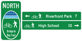
This figure illustrates two guide signs.  On the left, a modified M1-8a sign is shown with a white border, a pictograph of a river walk, the bicycle symbol, a pedestrian symbol, and the legend North "Bridge to Bay Trail".  On the right,  a modified D1-1 sign is shown with a white border and one white horizontal divider.  Above the divider is a left arrow, the bicycle symbol, a pedestrian symbol, the legend "Riverfront Park 7".  Below the divider is a bicycle symbol, the pedestrian symbol, the legend "High School 10" and a right arrow.

This treatment is currently experimental.

More information on the FHWA's active official experiments for bicycle route wayfinding signs can be found at the Official Rulings Database on the MUTCD Web site. Active official experiments for bicycle route wayfinding signs include:

  • 9(09)-14 - St. Clair County, MI
Updated: 8/25/2017
HEP Home Planning Environment Real Estate
Federal Highway Administration | 1200 New Jersey Avenue, SE | Washington, DC 20590 | 202-366-4000