U.S. Department of Transportation
Federal Highway Administration
1200 New Jersey Avenue, SE
Washington, DC 20590
202-366-4000
Which route is the best prospect for that rainy commute to work? Should we postpone our road trip to the mountains this weekend because of the snow?
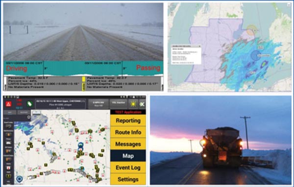
States participating in the road weather management — weather-savvy roads effort in Every Day Counts round four (EDC-4) can help motorists make those decisions. Road weather management can also help transportation departments deploy snowplows more efficiently and freight companies avoid hazardous wind conditions for truck drivers.
“Road weather management provides the information people need to make better decisions on when to travel, how fast to drive, and what routes to take,” said Paul Pisano, leader of the Federal Highway Administration Road Weather and Work Zone Management Team.
Twenty-two percent of all vehicle crashes in the past decade were weather-related. On average, these crashes resulted in nearly 6,000 deaths and more than 445,000 injuries a year. About 25 percent of nonrecurring traffic delays are due to adverse weather, and weather-related delays add about $3.4 billion a year to freight costs. Preventing crashes with winter maintenance approaches using anti-icing materials such as salt and sand affects watersheds, air quality, and infrastructure.
In 2017 and 2018, FHWA is encouraging deployment of two strategies that enable State and local agencies to proactively manage the surface transportation system ahead of and during adverse weather events: Pathfinder and integrated mobile observations. “Agencies can choose one or both of these solutions,” Pisano said.
Pathfinder is a collaborative process involving the National Weather Service, transportation departments, and private sector weather service providers to disseminate road weather information to travelers that is clear, concise, consistent, and impact-based.
“The ultimate goal is to make drivers well-informed and able to make safe and efficient travel decisions during weather events,” said Roemer Alfelor of FHWA’s Road Weather and Work Zone Management Team.
Utah is one of several States already using the Pathfinder process to deliver messages about weather events such as snow, freezing rain, and high winds.
Pathfinder and integrated mobile observations help drivers make better decisions before and during hazardous weather.
“We try to make the message as concise as we can,” said Jeff Williams, Utah Department of Transportation weather operations manager, citing highway variable message signs reading “ROAD SNOW 5 PM TUE” as an example. “We typically put out a message like that 18 to 24 hours in advance of a storm.”
A Utah study of snow events showed a 40 percent reduction in vehicle miles traveled, indicating that concise, consistent messaging works.
“We’ve seen a significant influence as far as the Pathfinder project is concerned,” Williams said. “When the National Weather Service, the media, and the DOT are saying the same thing about weather impact, we see people react.”
Although many highway agencies already work with weather information providers, “Pathfinder is about taking it to another level, particularly focusing on the consistency of the messaging to the traveling public,” said Pisano. “Pathfinder is an easy, low-cost solution to implement.”
“The goal of integrating mobile observations is to deploy advanced, vehicle-based technologies to collect, transmit, and use weather, road condition, and related vehicle data for improved transportation system management,” said Gabriel Guevara of FHWA’s Road Weather and Work Zone Management Team.
The data collected can be used for a number of road weather management strategies, such as winter maintenance decision support systems that enable agencies to use the right amount of labor, material, and equipment to pretreat roads.
“Ultimately, integrating mobile observations can help DOTs improve efficiency in terms of costs, effectiveness in terms of results, and accountability in terms of measurement,” Guevara said.
One agency using integrated mobile observations is the Michigan Department of Transportation (MDOT), which equipped 15 vehicles and 310 snowplows to collect camera images of road conditions and data such as air and surface temperature, relative humidity, and brake status. The data help maintenance workers use resources more efficiently. They’re also used to post motorist advisories on the MDOT Mi Drive Web site, a mobile application, and changeable message boards.
“You get a microlevel look at the roadway,” said Steven Cook, MDOT operations engineer. “You also get better information to provide to the public. We found out from surveys that folks changed their route or delayed their travel because of the information we posted.”
View an EDC-4 webinar on weather-savvy roads.
See Collaboration Across the Road Weather Enterprise: The Pathfinder Project for guidance on implementing the Pathfinder process and State DOT examples.
See FHWA’s Road Weather Management Web site for information, training, and upcoming events.
Contact Paul Pisano of the FHWA Office of Operations or Ray Murphy of the FHWA Resource Center for information and technical assistance.
The Federal Highway Administration is mounting a concerted drive to promote the deployment of automated traffic signal performance measures (ATSPMs) at State and local levels across the country.
As promoted through Every Day Counts round four (EDC-4), ATSPMs enable transportation agencies to incorporate objectives and performance-based approaches in traffic signal operations, maintenance, design, and management. Using ATSPMs can improve safety and customer service while cutting congestion and costs.
More than 330,000 traffic signals operate in the United States. Typically, highway agencies retime signals on a 3- to 5-year cycle at a cost of about $4,500 per intersection. For most signals, citizen complaints are the primary performance measure. The absence of data drives retiming costs up by requiring the use of surrogates such as software modeling to simulate performance, along with expensive manually collected traffic data.
ATSPMs are the outcome of technologies that provide data collection, analysis, and reporting capability to support an objective and performance-based approach to managing, operating, and maintaining traffic signals. The measures can be mapped to specific operations, management, maintenance, and design objectives.
ATSPMs are generated by a high-resolution data logger incorporated into standard traffic signal equipment. The data are collected automatically and are accessible through a software platform that helps the user visualize and summarize the information.
Eddie Curtis, FHWA traffic management and operations specialist, uses this analogy to explain how ATSPMs work: “Effectively, ATSPMs resemble a fitness tracker for traffic signals. Fitness trackers collect accelerometer data that is fed into analysis software to develop measures such as the number of steps taken, number of flights of stairs climbed, calories burned, and so forth. These measures can be used to support objectives such as increasing the amount of physical activity per day to improve fitness. People who wear fitness trackers generally are more empowered to meet their health and fitness goals than those who do not.”
Automated traffic signal performance measures improve on traditional signal retiming processes by providing continuous performance monitoring capability.
The Utah Department of Transportation (UDOT) is one of about 26 State and local transportation agencies already implementing ATSPMs, which are also being promoted through the American Association of State Highway and Transportation Officials Innovation Initiative.
“We are able to do more with less and manage traffic more effectively 24/7,” said Jamie Mackey, UDOT statewide signal engineer. “We have improved mobility by reducing the effort and time required to retime traffic signals. In addition, we are able to optimize intersections and corridors when they need to be reoptimized, instead of on a set schedule.”
To date, UDOT has deployed ATSPMs at 1,750 of the State’s 2,000 traffic signals. “We partnered with Purdue University, the Indiana Department of Transportation, and equipment vendors to make this work,” said Mackey.
Mackey outlined several ATSPMs benefits:
Agencies have a number of implementation options to fit a range of capabilities and resources. UDOT developed software —available at no cost on the FHWA Open Source Application Development Portal—to take advantage of a high-resolution data collection capability. In addition, a number of vendors have integrated this capability into cloud-based software and traffic signal control systems that can be purchased as turnkey systems to provide ATSPMs.
“There’s a solution to fit any size municipality or agency,” said Curtis. “I think that this tool should be in the hands of every traffic engineer.”
View an EDC-4 webinar on ATSPMs.
Read about a Transportation Pooled Fund study on Traffic Signal Systems Operations and Management.
See the AASHTO Innovation Initiative Web page on ATSPMs.
View live signal performance metrics case study sites for Las Vegas, NV; Seminole County, FL; and Utah.
Contact Eddie Curtis or Rick Denney of the FHWA Resource Center for information and technical assistance.
How can State Transportation Innovation Councils (STICs) lead the way in an era of rapid change?
Transportation professionals explored elements of effective STICs at a workshop at the Transportation Research Board 96th Annual Meeting in January in Washington, DC. The workshop was sponsored by the Committee on Technology Transfer (ABG30) and the Committee on Conduct of Research (ABG10).
“If you resist change, you lag behind. If you accept it, you survive. If you actually lead it, that’s when you thrive,” Thomas Harman, director of the Federal Highway Administration’s Center for Accelerating Innovation (CAI), told workshop participants. “That’s what we’re looking to do with the STIC network. We want to thrive in this changing environment.”
STICs—which bring together stakeholders to identify and deploy innovations—operate in all 50 States, Washington, DC, Puerto Rico, the U.S. Virgin Islands, and Federal Lands Highway. FHWA encouraged formation of the STIC network to create a strong culture of innovation in the transportation community and get innovations into practice quickly.
“We’ve established a STIC network. Now we need to nurture it and leverage it to its max,” said Harman.
The workshop focused on elements STICs need to develop an innovation culture in their States: origins of innovations, outreach and communication, telling a compelling story, and change management. After hearing presentations, participants broke into groups to discuss goals, challenges, and solutions to reinforce these elements in a STIC. CAI is compiling the groups’ recommendations and STIC best practices into a tool STICs can use to strengthen their efforts to lead change.
“Innovation is really about people,” David Esse, Wisconsin Department of Transportation (WisDOT) innovation officer, said in a presentation on how the Wisconsin STIC identifies innovations to advance. “The important thing is figuring out who can contribute, who wants to contribute, and who should contribute.”
In addition to working with external stakeholders through the Wisconsin STIC to consider innovations from the Every Day Counts (EDC) initiative and other sources, WisDOT formed an internal Innovation Review Committee to evaluate ideas. Committee members represent a range of agency functions, including traffic operations, project development, and information technology. Esse then assembled local innovation teams in WisDOT regions to draw frontline staff into the innovation process.
“Now our STIC has an external component, but we also have this critical internal and local component,” said Esse. “People are really investing their time. They want to make a difference.”
Jan Huzvar, Pennsylvania Department of Transportation (PennDOT) deputy communications director, discussed the importance of telling a compelling story about a STIC and the quantifiable benefits of the innovations it champions. This involves using outreach and communication strategies to build partnerships and share successes.
“You want to make your STIC relatable to your elected officials and the traveling public,” she said. “Use the communication tools you have right now. You don’t have to go out of your comfort zone.”
Among the communication tools PennDOT uses to provide updates on STIC innovation efforts are its Web page, Innovation in Motion newsletter, and social media. Other useful STIC education tactics include infographics, videos, news releases, and events.
“Have a communications person whose job it is to talk about your success because success breeds success,” Huzvar said.
Ben Huot, Utah Department of Transportation preconstruction engineer, outlined change management principles agencies and STICs can adopt to focus their efforts to create a culture of innovation, such as fostering leadership trust throughout an organization and following through on innovation initiatives to maintain momentum.
“An important first step is understanding what your existing culture is,” he said. “Look for ways to work to the strengths of the existing culture.”
Huot also reviewed techniques STICs can use to implement change, including identifying the right champions to lead innovation efforts, sharing information through effective messages, using a risk-based approach to analyzing innovation, and developing good relationships with industry partners.

View a video of Texas transportation leaders talking about their STIC’s purpose. Credit: Texas Department of Transportation
The STIC’s primary purpose is to provide a forum for transportation leaders to review and collaborate on innovation efforts that align with Texas transportation goals. Sources the STIC uses to generate ideas include council members, TxDOT’s research program, the Texas Technology Task Force, and EDC. Among the strategies the STIC uses to encourage stakeholder involvement in this large State is offering member organizations the option to attend meetings by webcast or send alternate representatives.
“We have an unprecedented $38 billion over the next 10 years that will be transferred through TxDOT,” Badgley said. “We’re looking forward to engaging with our local stakeholders through the STIC to make sure we’re making wise decisions with our public funding.”
Center for Accelerating Innovation (CAI) Director Thomas Harman outlined 10 keys to innovation deployment during the “State Transportation Innovation Councils: Leading the Way in an Era of Rapid Change” workshop. The strategies were identified by transportation leaders attending the Every Day Counts summits in fall 2016:
CAI welcomes ideas and comments at
innovation@dot.gov.
In what may be a national first, the Virginia Department of Transportation (VDOT) signed a programmatic agreement with five Federal and State partners to streamline highway project reviews under Section 106 of the National Historic Preservation Act of 1966.
The Federal Highway Administration, U.S. Army Corps of Engineers (USACE), Tennessee Valley Authority (TVA), Federal Advisory Council on Historic Preservation (ACHP), and State Historic Preservation Office (SHPO) joined VDOT in signing the August 2016 Section 106 agreement, which delegates decisionmaking responsibility to VDOT on projects with potential effects on historic properties.
“We believe our programmatic agreement is the first of its kind where multiple Federal action agencies have agreed to the Section 106 review procedures and have delegated major decisionmaking to a State DOT,” said John Simkins, Planning and Environment Team leader in FHWA’s Virginia Division.
Programmatic agreements, part of the first and second rounds of Every Day Counts, establish streamlined approaches for handling routine environmental requirements on common project types to increase efficiency while saving time and resources.
Virginia’s Section 106 agreement covers all VDOT projects that require FHWA, USACE, or TVA action. The agreement simplifies the environmental review process because instead of Federal agencies needing to demonstrate Section 106 compliance separately, compliance is accomplished all at one time.
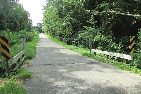
Virginia’s Section 106 programmatic agreement enabled the Virginia Department of Transportation to expedite the proposed replacement of a small bridge in Nottoway County after reporting a finding of “no historic properties present or affected.” Credit: Virginia Department of Transportation
“For the Federal-Aid Highway Program, Section 106 programmatic agreements among FHWA, the ACHP, SHPO, and State DOT are fairly common,” said Simkins. “However, those agreements do not cover the Section 106 responsibilities of other Federal agencies that have to take action on the project.”
Besides FHWA, the most common agency that needs to act on road projects is the USACE, which must issue permits for projects affecting waterways. Virginia’s agreement also includes the TVA, which must issue permits on some projects in the southwestern part of the State.
“VDOT’s qualified cultural resources staff were already evaluating projects for Section 106 issues and conducting coordination with SHPO, and the Corps was reviewing that coordination. This agreement eliminates redundancies related to those steps,” said Alice Allen-Grimes, USACE environmental scientist. “The new procedures definitely streamline the review process, saving time for VDOT, SHPO, and the Federal agencies without compromising the integrity of the Section 106 review.”
The Virginia agreement includes procedures to expedite the Section 106 review process for emergency situations and minor projects not affecting historic properties. It also defines a process to update Virginia’s historic bridge inventory.
“Most of the projects it covers are Federal-Aid actions with FHWA, but there are many hundreds of smaller, State-funded maintenance projects requiring permits from the U.S. Army Corps of Engineers that have benefited from its efficiencies,” said Antony Opperman, VDOT Cultural Resource Program manager.
As part of the agreement, VDOT posts a monthly list of minor projects it has determined will not affect historic properties.
“It would be reasonable to say that around 1,000 minor Federal actions annually that don’t harm historic properties will have environmental work completed faster by concluding Section 106 through the efficiencies provided by the programmatic agreement,” said Opperman. “In addition, those same efficiencies allow VDOT and SHPO staff to focus on the few projects affecting historic properties by spending as little time as possible on those that don’t.”
Safe driving in adverse conditions—whether rain, fog, or darkness—requires visible road markings. Retroreflective pavement markings that bounce light from vehicle headlights back to drivers’ eyes improve safety and prevent roadway departure crashes, but they must be maintained to ensure they remain visible over time.
Some highway agencies rely on fixed repainting schedules, while others measure retroreflectivity with handheld or mobile measurement systems to determine when pavement markings need to be repainted. A grant from the Federal Highway Administration Technology Partnerships program enabled Leetron Vision LLC of Concord, NH, to refine its prototype Mobile Retroreflectivity Unit (MRU) to improve its ability to handle various road and environmental conditions and collaborate with the Florida Department of Transportation to conduct field tests.
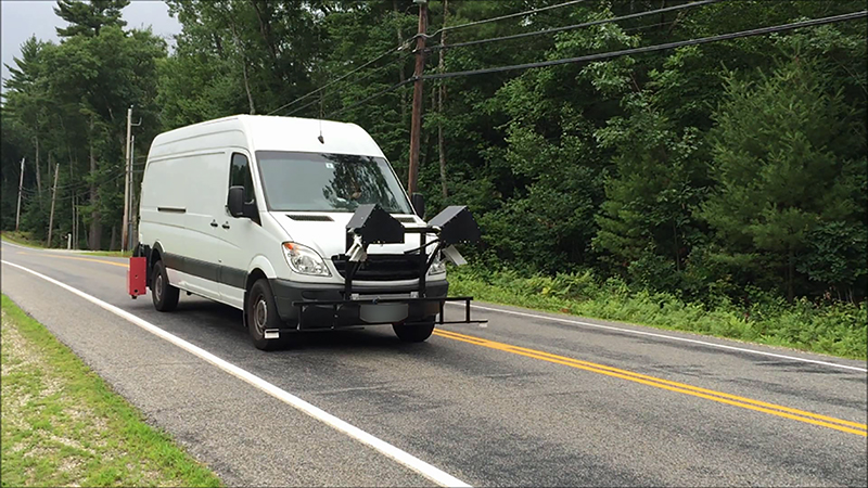
A Technology Partnerships grant helped refine a mobile measurement system agencies can use to determine when pavement markings need a new coat of paint. Credit: Leetron Vision LLC.
The MRU uses real-time laser tracking technology to measure pavement marking reflectivity at highway speeds. A new FHWA report, Advanced Methods for Mobile Retroreflectivity Measurement on Paving Marking, explains the technology, outlines steps taken to refine the Leetron unit, and discusses results of tests using the system to collect pavement marking data.
The Technology Partnerships program, part of the Highway for LIFE program to accelerate innovation use in transportation, provided grants to private industry to further develop proven, late-stage prototypes and evaluate them in real-world settings.
The Leetron system uses a method of tracking measurements in real time that mitigates the effects of vehicle motion and variance in the road profile, one of the most challenging aspects of mobile retroreflectivity measurement. Using variable geometry technology, the system aims a laser at the center of the pavement marking and uses a feedback loop to readjust the aim point as the vehicle equipped with the unit travels at highway speeds.
“In the process of finalizing the product from a prototype, a number of refinement cycles were incorporated in the testing to ensure that the unit remained capable of handling conditions in real-world settings,” system developer Terry Lee said in the report. “Extensive road testing and refinements helped develop a robust, commercial-ready system.”
The system offers a faster measurement method than traditional systems by allowing simultaneous measurement of markings in two lanes. It also has an automatic calibration capability that minimizes downtime and maximizes data collection.
An independent evaluation conducted by the Texas A&M Transportation Institute confirmed that the Leetron system can collect accurate retroreflectivity data on a range of paving marking types under a variety of challenging conditions. The evaluation included controlled testing in a laboratory and on an airfield runway along with field testing on open roads.
“The results of the comprehensive testing demonstrate Leetron Vision’s MRU using variable geometry technology is capable of accurately measuring pavement marking retroreflectivty under a broad range of real-world conditions,” the report said.
The Truckee River Bridge and Dollar Creek Trail project in Tahoe City, CA, is using several Every Day Counts (EDC) innovations, including the Safety Edge paving technique, accelerated bridge construction, roundabouts, road diets, and in-lieu fees and mitigation banking. The project is designed to improve safety and mobility for all travel modes. Federal Lands Highway collaborated with more than 20 agencies on the context-sensitive design for the project
The Delaware Department of Transportation opened the State’s first diverging diamond interchange at Delaware Routes 1 and 72 in New Castle County. The agency used the design-build delivery method on the project, which received Accelerated Innovation Deployment (AID) Demonstration funding. Using the diverging diamond interchange design may have reduced construction time and costs by 75 percent compared to traditional alternatives.
The Minnesota Department of Transportation (MnDOT) deployed a variable downstream speed notification system on an I-94 pavement project in St. Paul and Maplewood during the 2016 construction season. The system—one of the smarter work zone technology strategies recommended in EDC round three—notifies drivers of downstream traffic speeds to better manage speeds and reduce crashes when work zone congestion develops. MnDOT plans to use the system again in 2017.
Using accelerated bridge construction saved months of construction time on a project to replace the Ochoco Creek Bridge in Prineville, OR. The existing bridge was removed and the new bridge—constructed next to the old bridge—was moved into place with slide-in bridge construction during a 3-week closure. Using conventional construction would have required closing the bridge for more than 3 months.

Credit: Creative Communications Section, Wisconsin Department of Transportation
A time-lapse video from the Wisconsin Department of Transportation (WisDOT) demonstrates the use of geosynthetic reinforced soil-integrated bridge system (GRS-IBS) technology to replace a bridge on County Highway S over Shaw Brook in Dodge County. WisDOT and Dodge County received AID Demonstration funding for two GRS-IBS projects, the first use of the technology on a local highway in the State.
Innovator, published by the FHWA Center for Accelerating Innovation, advances implementation of innovative technologies and accelerated project delivery methods in the highway industry. Its audience is transportation professionals in highway agencies, trade and research groups, academia and the private sector, and the driving public.
Elaine L. Chao, Secretary, U.S. DOT
Walter Waidelich, Jr., Acting Deputy Administrator, FHWA
Thomas Harman, Director
Jeffrey Zaharewicz, Senior Advisor
Ewa Flom, Program Coordinator
Sara Lowry, Program Coordinator
Julie Zirlin, Program Manager
Nichole Causey, Marketing Specialist
Ellen Schweppe, Managing Editor
James Cline, Jr., Designer
Rebecca Taylor, Designer
Rodney Walker, Designer
Email reprint requests to Nichole Causey

