U.S. Department of Transportation
Federal Highway Administration
1200 New Jersey Avenue, SE
Washington, DC 20590
202-366-4000
Federal Highway Administrator Nicole R. Nason will launch the next round of Every Day Counts innovations at a webinar on September 23, 2020. Seven innovations will be promoted in the sixth round of Every Day Counts (EDC-6), the State-based program to rapidly deploy processes and technologies to boost the safety and efficiency of the transportation system and keep America moving.
The EDC-6 innovations feature strategies to increase engagement with the people who build and use the transportation infrastructure, products to save money on preserving and repairing bridges and roads, and processes to save time on project delivery and incident management.
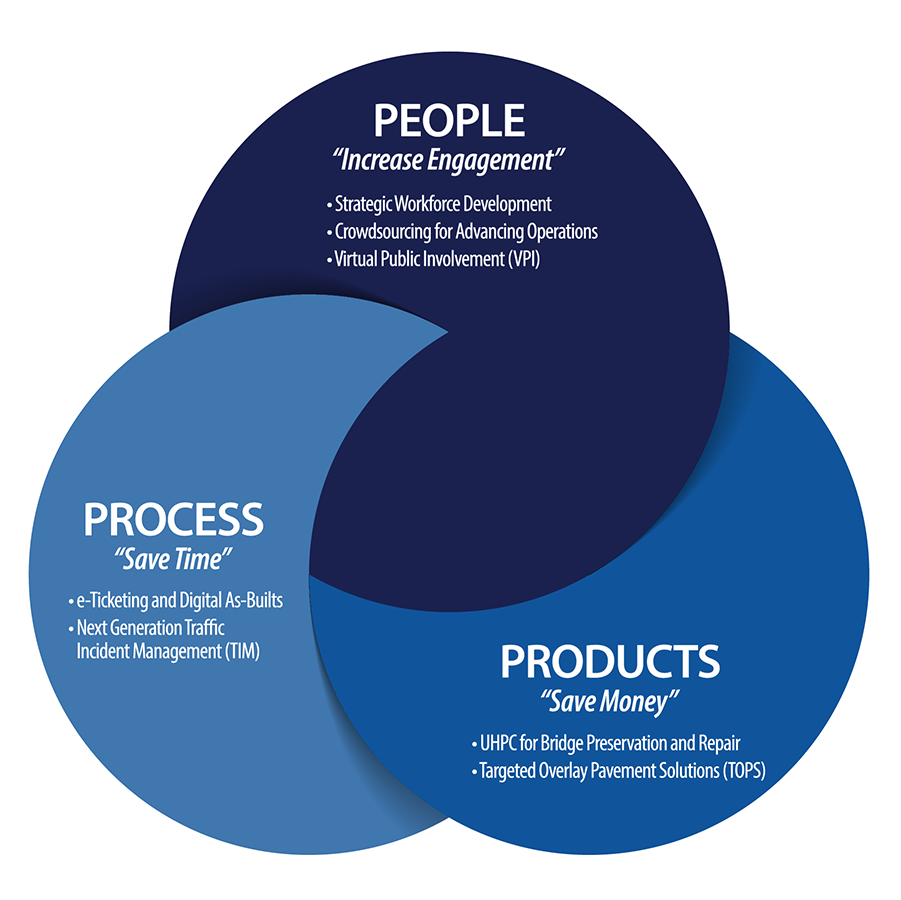
FHWA’s call for ideas for EDC-6 yielded more than 100 suggestions from local, State, and Federal agencies; academia; and industry. After consulting with the American Association of State Highway and Transportation Officials and other stakeholders, FHWA selected seven proven, market-ready innovations to promote in 2021 and 2022.
This fall, FHWA’s Center for Accelerating Innovation (CAI) will hold a virtual summit on the EDC-6 innovations for all transportation stakeholders. Starting in January, EDC-6 deployment teams will provide technical assistance and training to help transportation agencies implement the innovations State Transportation Innovation Councils choose to adopt in their States.
State and local transportation agencies need real-time, high-quality, and wide-ranging information to optimize roadway operations for reduced congestion and increased safety. Agencies are increasing the quality and quantity of operations data with crowdsourcing, which enables staff to make better decisions that lead to safer and more reliable travel and apply proactive strategies cost effectively. With crowdsourced data from multiple streams, agencies can capture in real time what happens between sensors, in rural areas, along arterials, and beyond jurisdictional boundaries. Learn More >
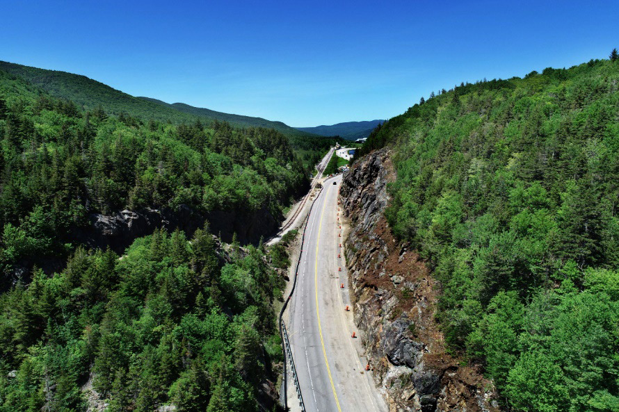
Crashes dropped 80 percent at a Jackson County, MS, location after signing, striping, and shoulder improvements were installed as part of a bundled project.
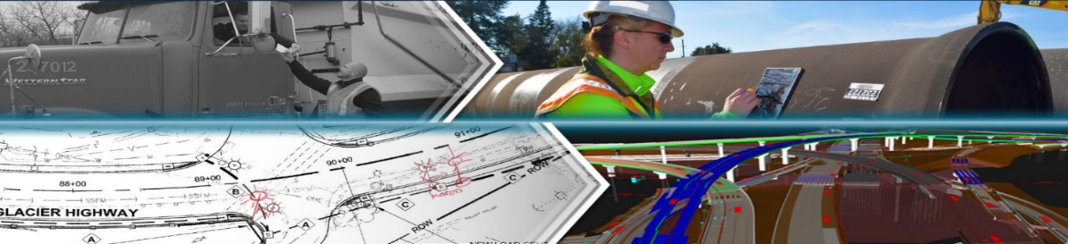
Highway construction projects generate massive amounts of valuable data that historically were communicated via paper, but agencies are improving on paper process by integrating them into electronic and digital workflows. Electronic ticketing improves the tracking, exchange, and archiving of materials tickets. Digital information, such as three-dimensional design models and other metadata, enhances the future usability of as-built plans for operations, maintenance, and asset management. Both can increase project safety, quality, and cost savings through efficient data gathering and sharing. Learn More >
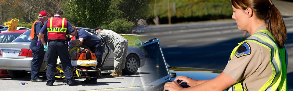
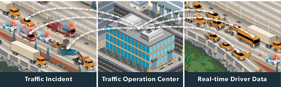
More than 6 million traffic crashes are reported each year, creating congestion and putting motorists and responders at risk of secondary crashes. Next-generation traffic incident management (NextGen TIM) builds on FHWA’s national TIM responder training program to shorten the duration and impact of incidents and improve the safety of motorists, crash victims, and responders. NextGen TIM offers tools, data, and training mechanisms that can benefit both new and existing TIM programs, including local agency and off-interstate applications. Learn More >

The demand for highway construction, maintenance, and operations workers is growing while the transportation industry is experiencing a revolution of emerging technologies that require new skills. The Highway Construction Workforce Partnership developed strategies and resources to demonstrate the value of a career in transportation and fill the jobs that support the Nation’s highway system. Resources include the “Identify, Train, Place” workforce development playbook and Roads to Your Future outreach campaign to attract and retain workers in highway construction jobs. Learn More >
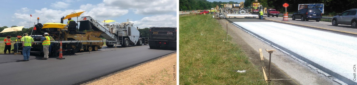
Pavement overlays represent a significant portion of highway infrastructure dollars. Many pavements in the highway system have reached or are nearing the end of their design life while carrying traffic that exceeds their initial design criteria. Targeted overlay pavement solutions (TOPS) are now available for asphalt and concrete pavements that enable agencies to maximize their investment and help ensure safer, longer-lasting roadways. TOPS will improve performance, lessen traffic impacts, and reduce the cost of pavement ownership. Learn More >
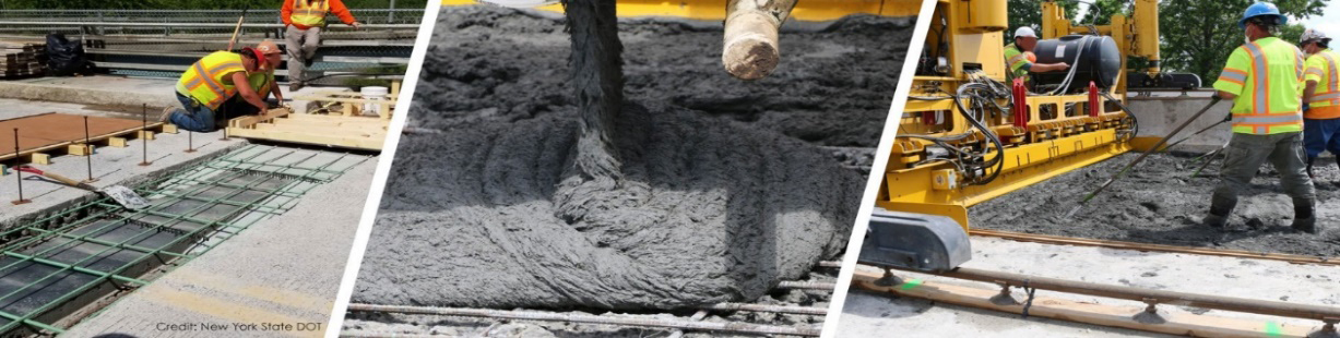
Ultra-high performance concrete (UHPC)—a fiber-reinforced, cementitious composite material with mechanical and durability properties that far exceed those of conventional concrete—has become popular for field-cast prefabricated bridge elements. Bridge preservation and repair is a new application of UHPC that offers superior strength, enhanced performance, and improved life-cycle cost over traditional methods. Learn More >
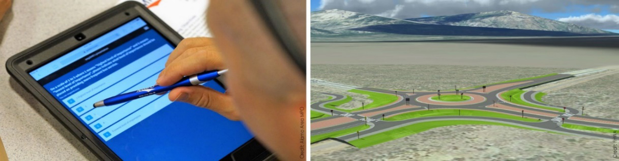
Public engagement during transportation project planning and development helps agencies identify issues and concerns early in the process, which can ultimately accelerate project delivery. Virtual public involvement supports agency efforts to engage the public more effectively by supplementing face-to-face information sharing with technology. Techniques such as telephone town halls, online meetings, and social media increase the number and variety of ways to inform the public, receive feedback, and collect and consider stakeholder input. Learn More >
Go to the EDC-6 innovations web page for information, resources, and contacts.
Contact Julie Zirlin of the FHWA Center for Accelerating Innovation for information on the EDC program.
Two-dimensional (2D) hydraulic modeling has come of age. Recent advances in computing power, user interface improvements, and training resources have made this 25-year-old technology readily available for application to hydraulic modeling analyses.
Promotion through the Every Day Counts (EDC) initiative on collaborative hydraulics: advancing to the next generation of engineering (CHANGE) has encouraged transportation agencies to adopt 2D modeling to improve project outcomes. The number of States at the demonstration, assessment, or institutionalized stage of CHANGE deployment has nearly tripled from 17 at the beginning of 2017 to 46 today.
Agencies are finding that 2D models provide a more accurate representation of complex hydraulic conditions typically encountered in the real world because they avoid many of the assumptions required by traditional one-dimensional (1D) models. These 2D models also aid in communicating hydraulic concepts to stakeholders through intuitive graphics and videos.
“We have a much better understanding of site conditions hydraulically, so it enables us to come up with better solutions that result in more reliable, more resilient, and safer structures,” said Scott Hogan, Federal Highway Administration senior hydraulic engineer and CHANGE team co-leader.
FHWA developed “Two-Dimensional Hydraulic Modeling for Highways in the River Environment” to explain the advantages of 2D hydraulic modeling for transportation applications and provide an overview of model development and execution. The reference document covers information relevant to all 2D hydraulic models and includes a user’s manual for the SMS/SRH-2D graphical user interface, which FHWA recommends for bridge hydraulics and scour analyses.
The CHANGE team is collaborating with the National Highway Institute on training courses, including a course on 2D Hydraulic Modeling of Rivers at Highway Encroachments that now offers a virtual option. “There has been a very high demand for this training, and we will continue to schedule courses until the demand runs out,” said Hogan. “The virtual version will reach many who did not have access to the instructor-led courses.”
In addition, more than 1,500 members participate in the 2D Hydraulic Modeling User’s Forum, which delivers bimonthly webinars on best practices, technical support for users, and tips for efficient modeling.
The Arizona Department of Transportation (ADOT) is among the agencies that set a goal to institutionalize the use of 2D hydraulic modeling tools to design safer, more cost-effective, and more resilient structures on waterways. To meet the goal, ADOT developed standardized 2D modeling project assessment scoping language, bridge hydraulic guidance, and stormwater design guidance.
ADOT has nine pilot projects involving 2D hydraulic modeling identified, underway, or completed. ADOT reports that over 2 years, it leveraged $100,000 in State Transportation Innovation Council Incentive funds to gain $400,000 in design engineering benefits on projects. This was achieved by including funds in project design budgets to use 2D hydraulic modeling instead of traditional 1D methods.
The Mississippi Department of Transportation (MDOT) is also seeing the value of incorporating 2D modeling into hydraulic analyses. MDOT used the technology to analyze a complicated bridge rehabilitation project on Lynch Creek in Jackson. The modeling needed to accommodate merging floodplains, multiple hydraulic structures, and skewed flow.
MDOT found that 2D modeling captured the Lynch Creek site conditions with a level of detail that 1D modeling could not convey. The 2D models also offered MDOT superior options for presenting results to project stakeholders. Using 1D modeling would have provided results only where cross sections were placed, while 2D modeling provided results over the entire project area and could be rendered in an easy-to-interpret visual format with images of detailed water flow paths, elevation, and velocity.
The Washington State Department of Transportation (WSDOT) has used 2D modeling on several projects, including bridge replacements, bridge scour countermeasure design, fish barrier removal projects, and bridge scour emergencies. After the removal of two dams on the Elwha River in northwest Washington, the State declared an emergency on the existing U.S. 101 Elwha River Bridge because of changes in river conditions and susceptibility of the foundations to scour. WSDOT used 2D modeling to assess the vulnerability of the bridge and reported that 2D modeling was instrumental in communicating risk in the department and ensuring driver safety.
For the proposed bridge replacement, WSDOT has used 2D modeling throughout the project delivery process. This includes assessing the performance of a scour countermeasure constructed during the emergency declaration, designing the new structure, evaluating potential environmental effects such as aquatic habitat impacts, and identifying potential stream diversion parameters to be used during construction.
View an Innovation Spotlight video on how new tools make 2D hydraulic modeling more efficient, intuitive, and accessible to engineers and designers.
Visit FHWA’s hydraulic engineering web page for guidance, reports, software downloads, and training information.
Contact Scott Hogan or Laura Girard of the FHWA Resource Center for information and technical assistance.
Knowing what lies beneath the surface is critical to ensuring safe and cost-effective highway projects. Conventional subsurface exploration methods yield limited data for project design, which can result in constructability issues and increased costs. The Every Day Counts round five (EDC-5) initiative on advanced geotechnical methods in exploration (A-GaME) showcases proven but underused techniques to gather more detailed information on site conditions.
Combined with conventional boring data, A-GaME solutions can boost confidence in geotechnical site characterization. This can improve design and construction, leading to shorter project delivery times and lowering the risks associated with limited data on subsurface conditions. “Reducing uncertainties is the focus of the A-GaME,” said Ben Rivers, Federal Highway Administration geotechnical engineer and EDC-5 team co-leader.
A-GaME features five geotechnical exploration methods: cone penetration testing (CPT), electrical geophysical techniques, measurement while drilling, seismic geophysical methods, and optical and acoustic televiewers. “But we don’t want to exclude other geotechnical methods or use one method alone,” Rivers said. “We want to determine what methods to use together to provide us with the best understanding of subsurface site characteristics.”
More than 45 State and Federal agencies are using A-GaME strategies to reduce geotechnical project risks and improve reliability, including 27 agencies that are at the demonstration, assessment, or institutionalized stages of deployment. This fall and winter, the EDC-5 team will offer new web-based resources, such as virtual peer exchanges, training sessions, and demonstrations, to replace in-person events originally planned for 2020.
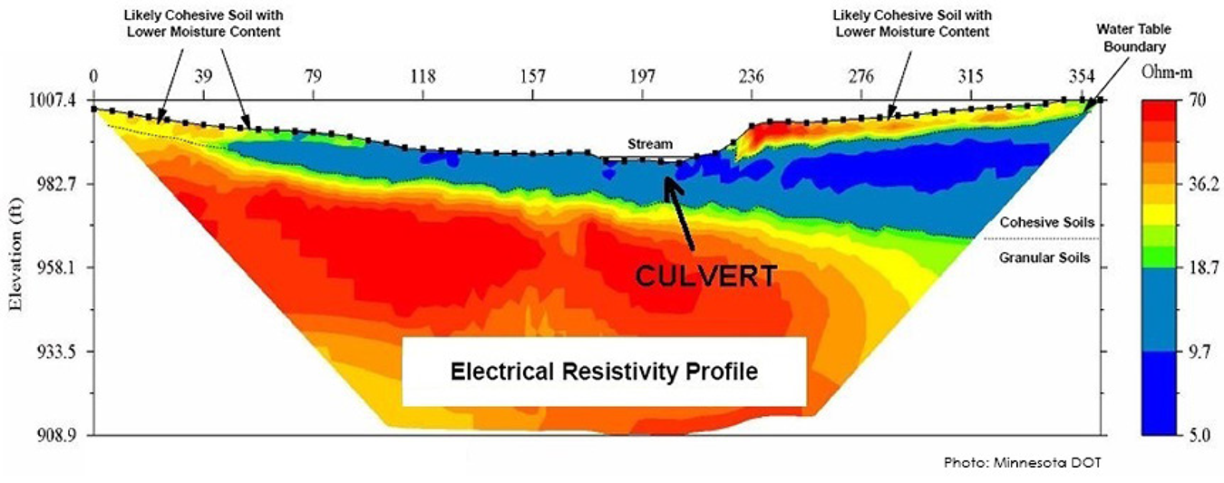
The Indiana Department of Transportation (INDOT) has used electrical resistivity tomography, a method to image the subsurface using differences in measured electrical resistivity, on several projects. This method helped INDOT design a bridge project on U.S. 50 in an area of Lawrence County with karst, a type of landscape where dissolving bedrock has created hazards such as sinkholes, sinking streams, and caves. The data showed designers the location of problematic rock stratus and aided in the design of a stable slope.
INDOT combined electrical resistivity tomography with multichannel analysis of surface waves on an exploration for an Interstate 69 project in Marion County. During their investigation, crews discovered a large concrete boulder hidden underneath a reclaimed landfill, which will be part of the I-69 alignment. Locating this feature ahead of the project will reduce construction change orders later.
The Michigan Department of Transportation (MDOT) has completed about 30 CPT soundings at eight locations, most near traditional borings. On a culvert replacement project on M-66 near East Jordan, MDOT conducted CPTs before traditional drilling and sampling. The CPT data indicated a weak layer beneath the surface, which was targeted for additional sampling during soil borings. The additional testing and CPT data added valuable information to the decision-making process, leading MDOT to change the culvert type and construction process from part width to detour, which reduced risk to the traveling public and the project.
The Wisconsin Department of Transportation (WisDOT) conducted GPR investigations on two projects this year. These investigations included assessing if underground storage tanks were present on WisDOT right-of-way on U.S. 14 in Mazomanie and determining the location and extent of clay sewer pipe beneath an urban section of State Trunk Highway 96 in Kaukauna. In both cases, GPR provided information on subsurface conditions the project design and construction teams needed at a significant cost savings over conventional investigation methods.
View an Innovation Spotlight video on how A-GaME technologies can improve project designs and ensure safe, cost-effective projects.
Read “Influence of Geotechnical Investigation and Subsurface Conditions on Claims, Change Orders, and Overruns” to learn how targeted changes in subsurface investigation practices can produce significant results.
Contact Ben Rivers of the FHWA Resource Center or Silas Nichols of the FHWA Office of Infrastructure for information, technical assistance, and training.
Pairing advanced geotechnical methods and unmanned aerial systems yields benefits
The New Hampshire Department of Transportation (NHDOT) combined two Every Day Counts innovations—advanced geotechnical methods in exploration (A-GaME) and unmanned aerial systems (UAS)—to improve condition assessment and stability evaluation of rock slopes.
NHDOT funded a research project through the University of Vermont (UVM) that assessed the use of UAS to make transportation project development safer, more cost efficient, and more effective. One focus of the study was on Route 302 in Crawford Notch State Park, which had a 100-foot high rock cut-slope with a poor overall stability rating.
Traditionally, rock structure conditions influencing stability of rock slopes are mapped using manual measurement. Introducing UAS to the process allowed engineering geologists to capture rock structure data in areas accessible only by rope or too difficult and dangerous to reach at all. UVM collected 310 high-resolution images during UAS flights in Crawford Notch.
NHDOT used photogrammetry techniques, one of its A-GaME methods for rock slope characterization, to create a detailed three-dimensional (3D) point cloud model. This technique is faster than traditional methods, and the number of measurements obtained by analyzing photogrammetric data provides better characterization of rock structure conditions, resulting in a more comprehensive stability analysis of the cut.
Data analyzed from the 3D point cloud can be transferred into other software for further analysis, visualization, and future access. Detailed 3D models like these allow engineering geologists and geotechnical experts to make better decisions on the stability of new cut-slope designs and geologic hazards from existing rock slopes. Measurements taken over time can also help detect changes in rock slopes. Asset managers can detail these changes and monitor slopes for movement that may indicate the potential for rockfall releases or rockslides.
Contact Ben Rivers of the FHWA Resource Center or Silas Nichols of the FHWA Office of Infrastructure for information on A-GaME.
Contact James Gray of the FHWA Office of Infrastructure or John Haynes of the FHWA Utah Division for information on UAS.
The Iowa Department of Transportation (DOT) developed a virtual public involvement platform to manage its stakeholder outreach and improve project decision making and is now making the tool available to other highway agencies.
As mobile phone, internet, and social media use grows, agencies are turning to virtual public involvement—the use of digital technology to engage people or visualize projects—to supplement in-person public involvement strategies during planning and project development.
The Iowa DOT created its Public Involvement Management Application (PIMA) to expand citizen input on transportation projects, reduce manual processes, and improve consistency of data collection for public meetings. “PIMA allows us to manage and coordinate our public involvement effort across our organization,” said Brad Hofer, director of the Iowa DOT Right-of-Way Bureau.
The agency had several goals in developing PIMA, which features both an internal management tool and a public portal. “We wanted to better analyze and adjust our public involvement effort based on real data,” said Hofer. “We also wanted to improve the ease with which the public can provide feedback on all our projects.”
Traditionally, the Iowa DOT held public meetings primarily for larger, more complex projects. “We wanted a public space that gives everybody an opportunity to comment on every project,” said Hofer.
The searchable public portal gives users information on all Iowa DOT projects and details from any past public meetings. It also displays the level of support a project has received, which is based on comments that have been submitted. In addition to providing a way for people to learn about and comment on projects, PIMA allows Iowa DOT staff to respond to and manage citizen comments electronically.
In recent months, the Iowa DOT has used PIMA for online public information meetings, offering participants the opportunity to view a prerecorded presentation at their convenience and make comments as they watch. Meeting materials can include visuals such as videos, story maps, and slide presentations.
“With PIMA, Iowa has been able to continue business as usual,” said Valerie Brewer, public involvement manager. The agency is working on the capability to livestream public information meetings in the future.
The Iowa DOT has demonstrated the PIMA platform to other State DOTs interested in using it for their public involvement efforts. The Georgia and Massachusetts Departments of Transportation have incorporated PIMA into their processes and others are considering implementation.
The Iowa DOT offers PIMA free by agreement with the stipulations that other agencies give Iowa credit for PIMA when appropriate, not share proprietary information with others, and share any improvements they make with Iowa. “We’re excited that this will continue to stimulate innovation around virtual public involvement,” Hofer said.
Contact Brad Hofer, Valerie Brewer, or John Rees of the Iowa DOT for details on the PIMA tool’s applications and benefits.
Contact Carolyn Nelson of the FHWA Office of Planning, Environment, and Realty for information on virtual public involvement.
The Illinois Department of Transportation (IDOT) and city of Joliet conducted virtual public outreach over the summer to gather input on the proposed Interstate 55 at Illinois 59 access project. The purpose of the project is to address congestion and provide safer, more efficient travel on I-55 and regional and local roadway networks. Instead of holding an in-person public meeting, IDOT invited the public to visit the project website to learn about and comment on preferred project alternatives and next steps of the project study. This virtual public involvement effort complemented earlier public meetings to explain the study process and solicit feedback. In addition to the website, outreach included a mailed newsletter and the opportunity to ask questions and leave comments for IDOT staff by phone.
The Maine Department of Transportation (MaineDOT) is advancing its use of crowdsourced data to monitor road conditions. The agency developed and is testing an application for work crews to more easily and safely communicate weather and road conditions. In the past, crews radioed MaineDOT’s Traffic Management Center to share information, which led to report backlogs during storms and reports that stayed active for too long. Information reported with the new app is available through MaineDOT’s Compass Advanced Traffic Management System and on NewEngland511.org when poor driving conditions are reported. The app improves the temporal accuracy of road and weather data and allows the traffic center to focus on incident identification and response during storms.
The North Carolina Department of Transportation (NCDOT) has benefited from using project bundling on a variety of project types, including bridge and culvert construction, emergency repairs, pavement resurfacing, maintenance activities, bridge scrubbing, bridge joint repair, safety improvements, traffic operation improvements, and intelligent transportation systems. Through bundling, NCDOT has experienced cost savings and increased efficiencies in several phases of project delivery. Benefits include the ability to standardize design elements across multiple projects, lower contract administrative and mobilization costs, and more effective use of crews and equipment. NCDOT has found that letting individual projects can limit bidder interest, but bundling projects can attract more attention and increase competition.
To expand its paperless initiative and improve asset management, the Utah Department of Transportation (UDOT) implemented electronic ticketing for hot-mix asphalt deliveries. Using State Transportation Innovation Council Incentive funds, UDOT completed seven e-Ticketing pilot projects that collected more than 2,900 electronic tickets, representing nearly 70,000 tons of asphalt placed. In the past, it was difficult to determine where on a project the material covered by an individual ticket was placed. Using e-Ticketing allows UDOT to map the location of materials so it can create an accurate record of its largest asset for pavement management purposes. e-Ticketing also improves safety for UDOT inspectors because they do not have to collect paper tickets from delivery drivers and eliminates the need for crews to total tickets on a jobsite, reducing computational errors. UDOT plans to expand e-Ticketing for asphalt, as well as pursue it for concrete deliveries.
The newest way to learn about agency successes with Every Day Counts (EDC) innovations is Innovation Conversations—audiocasts pairing EDC team leads with transportation professionals from across the country.

As pedestrian fatalities increase, agencies are working to make pedestrians in their communities safer. In this Innovation Conversation audiocast, Peter Eun of the EDC Safe Transportation for Every Pedestrian (STEP) team and Mark Cole of the Virginia Department of Transportation (VDOT) discuss pedestrian safety, VDOT’s Pedestrian Safety Action Plan, and the importance of building a diverse stakeholder group to address this issue.
Subscribe to be notified when new Innovation Conversation episodes launch.
Contact Becky Crowe of the FHWA Office of Safety or Peter Eun of the FHWA Resource Center for information and technical assistance on STEP strategies.
Innovator, published by the FHWA Center for Accelerating Innovation, advances implementation of innovative technologies and accelerated project delivery methods in the highway industry. Its audience is transportation professionals in highway agencies, trade and research groups, academia and the private sector, and the driving public.
Elaine L. Chao, Secretary, U.S. DOT
Nicole R. Nason, Administrator, FHWA
Thomas Harman, Director
Jeffrey Zaharewicz, Senior Advisor
Sara Lowry, Program Coordinator
Fawn Thompson, Program Coordinator
Julie Zirlin, Program Manager
Nichole Causey, Marketing Specialist
Ellen Schweppe, Managing Editor
James Cline, Jr., Designer
Pat Holcombe, Designer
Rodney Walker, Designer
Access past issues in the Innovator Archive and have the next issue sent to your mobile device by texting "FHWA Innovation" to 468311. Email reprint requests to Nichole Causey.

