
This fact sheet introduces engineering design professionals to the Institute of Transportation Engineers recommended practice (RP) Designing Walkable Urban Thoroughfares: A Context Sensitive Approach as a tool for designing urban streets that are compatible with and supportive of the surrounding context and community. It describes the physical, operational, policy, and multimodal characteristics that thoroughfare designers need to consider when selecting the design criteria that will affect the speed of vehicles. This fact sheet emphasizes the need to carefully consider a broader range of “design controls” that affect the development of walkable urban thoroughfares.
Design controls are physical and operational characteristics that guide the selection of criteria for designing thoroughfares. Some design controls are fixed—such as terrain, climate, and certain driver performance characteristics—but most controls can be influenced in some way through design via a process the designer controls. This is accomplished by establishing a basis from which criteria, geometric design elements, and dimensions are selected. Certain design controls, such as the vehicle speed the thoroughfare is designed to accommodate, have a greater influence on thoroughfare design than other controls. A key premise of context sensitive solutions (CSS) is that the approach to design and the controls emphasized by the designer will guide the design process from start to finish.
The American Association of State Highway and Transportation Officials’ (AASHTO) A Policy on Geometric Design of Highways and Streets (Green Book) and A Guide for Achieving Flexibility in Highway Design identify design controls and establish design criteria. AASHTO identifies a number of design controls that have varying degrees of influence on thoroughfare design (see box in following column). AASHTO recognizes the influence that context has on driver characteristics and performance and how design controls respond to these influences. The Green Book defines the environment, or context, as “the totality of humankind’s surroundings: social, physical, natural, and synthetic” and states that full consideration to environmental factors should be used in the selection of design controls. The RP emphasizes design controls and critical design elements in urban contexts consistent with both of AASHTO’s publications.
AASHTO identifies functional classification and design speed as primary factors in determining highway design criteria. Functional class categorizes facilities by traffic service such as high speed, long distance, uninterrupted travel, and so forth. Design speed is a selected speed used by the designer to determine certain design criteria. Although it used to be defined as the “maximum safe speed,” FHWA’s Flexibility in Highway Design highlights that design speed should be logical with respect to topography, anticipated operating speed, adjacent land use, and functional class. The Green Book separates design criteria by functional classification and two classes of context: rural and urban. The primary differences between the streets in these two contexts are the speed at which they operate, the mix and characteristics of the users, and the constraints of the surrounding context.
AASHTO Design Controls
There are several design controls in the application of CSS principles that may be used differently than in the conventional design process. These controls include speed, location, design vehicle, and functional classification.
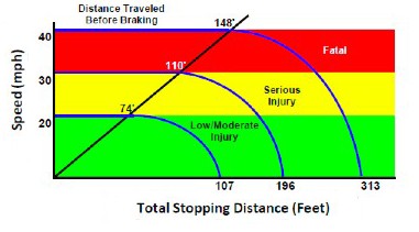
The RP recommends replacing design speed with a “target speed.” A lower target speed is an essential characteristic of thoroughfares in walkable, mixed-use urban areas (see Figure 1). Target speed is the highest speed at which vehicles should operate on a thoroughfare in a specific context, consistent with the level of multimodal activity generated by adjacent land uses, to provide both mobility for motor vehicles and a safe environment for pedestrians, bicyclists, and public transit users. The target speed is intended to be used as the posted speed limit. In some jurisdictions, the speed limit is established based on measured speeds. In these cases, it is important for the design of the thoroughfare to encourage an actual operating speed that equals the target speed.
Conventional thoroughfare design is controlled by location to the extent that it is rural or urban (sometimes suburban). Although the RP focuses on urban locations, it addresses the variation in intensity from suburban to highly urban areas.
Additionally, the variation in thoroughfare design, controlled by location, is expanded in the RP to include predominant land uses such as residential and commercial. Combinations of land uses govern multimodal activity, which in turn influences the design of the thoroughfare. In CSS, the thoroughfare designer works collaboratively with stakeholders to look toward the future and consider planned land uses that represent a departure from existing development patterns. The location may be of special value to the community, in which case the designer must seek solutions that protect scenic, environmental, historic, cultural, or other valuable community resources.
Traditionally, a design vehicle is the largest vehicle that uses a street with considerable frequency. A design vehicle influences the selection of criteria such as lane width and curb radii. Some practitioners tend to conservatively select the largest design vehicle that could use a thoroughfare, regardless of the frequency—usually a tractor-trailer truck. Consistent with AASHTO, CSS emphasizes the adoption of an analytical approach in the selection of a design vehicle. This approach includes evaluating the traffic engineering, safety, land use, livability, and sustainability impacts, including evaluation of the tradeoffs of selecting one design vehicle over another.
In walkable urban areas, it is not desirable to choose the largest vehicle that occasionally uses the facility. Designing for large vehicles increases pedestrian crossing distances and increases the speed of turning vehicles—outcomes that reduce pedestrian comfort and may be incompatible with the community vision and with the goals and objectives for the thoroughfare. In contrast, the selection of a small vehicle for the design of a thoroughfare regularly used by large vehicles can cause frequent operational and safety problems. The RP promotes selection of the largest design vehicle that will use the facility with considerable frequency and recommends consideration of two types of vehicle:
Design Factors That Influence Target Speed
Establishing a target speed that is artificially low relative to the design of the thoroughfare will only result in operating speeds that are higher than desirable and that are difficult to enforce. The design of the thoroughfare should start with the selection of a target speed, which is then applied to geometric design elements.
The following design factors contribute to speed reduction and should be incorporated into thoroughfare designs as appropriate in urban areas:
Functional classification defines the function and role of a thoroughfare in the network and governs the selection of certain design controls. Functional class is used to determine features such as the thoroughfare’s continuity through an area and the types of places it connects, the purpose and length of the trips it accommodates, its level of access to adjacent land development, the type of freight service, and the types of public transit that need to be accommodated.
Pedestrian and bicyclist requirements affect the utilization of the thoroughfare’s right of way. Thoroughfares with high levels of pedestrian and bicycle usage require appropriate streetside and bicycle lane facilities. This requirement usually affects the design elements in the traveled way. Therefore, pedestrian and bicycle requirements function as a control that influences decisions for the utilization and prioritization of all elements within the right of way. CSS thoroughfare designs emphasize allocating right of way appropriately to all users depending on the community’s priority and as defined by the surrounding context.
The conventional design process uses traffic projections and strives to provide the highest practical traffic level of service. CSS in thoroughfare design considers traffic projections and level of service as part of the process of balancing the needs of all users. CSS may emphasize one user over another if the context and circumstances necessitate this decision. While capacity and vehicular level of service play a role in selecting design criteria, they are only two of many factors considered in the design of urban thoroughfares. In urban areas, traffic capacity may be subjugated to economic development or historical preservation. CSS emphasizes network capacity as opposed to the capacity of the individual thoroughfare.
Institute of Transportation Engineers, 1627 Eye Street, NW, Suite 600, Washington, DC 20006 USA; Phone: 202-785-0060; www.ite.org.
This project was funded by FHWA’s Office of Planning, Environment and Realty’s Surface Transportation Environment and Planning Cooperative Research Program and the Environmental Protection Agency. Download the recommended practice and additional fact sheets at: www.ite.org/css/

