CHAPTER 4.0 OPERATIONAL CHARACTERISTICS
This chapter focuses on the movements of freight along the networks, operating capacity, and operating safety. There is a discussion of the highway freight bottlenecks in the corridor that comes directly from An Initial Assessment of Freight Bottlenecks on Highways. The measurement of the bottlenecks, both nationally and within the corridor, was included in Phase 1 of the Strategic Multimodal Analysis (SMA). Finally this chapter addresses the safety of the highway and rail systems.
4.1 Highway Operations
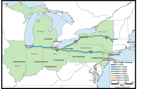
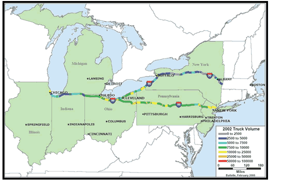
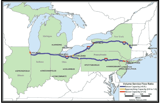
Table 4-1 shows the traffic volume and percentage of trucks by State on the I-80 and I-90 highways between Chicago and New York City. Truck traffic as a percentage of the total traffic picture varies across the corridor. Ohio and Pennsylvania show the highest percentage of trucks in the traffic mix. Figure 4-1 shows the average annual daily traffic (AADT) and Figure 4-2 shows the average annual daily truck traffic (AADTT) volume on the I-80/I-90 highways linking Chicago to New York City. Truck traffic includes single unit trucks and combination trucks. These figures, based on 2002 traffic data, indicate that traffic on these two Interstate highways range between 2,000 to 5,000 vehicles a day. Highway I-90 between Cleveland and New York carries truck traffic of 7,000 to 10,000 trucks per day and 20,000 to 25,000 per day at some locations, especially close to the major cities. Truck traffic on the I-90 portion (Cleveland to New York) is higher than on I-80 between Cleveland through Buffalo to Albany. Figure 4-3 illustrates the variation of service-volume ratios along the I-80/I-90 highways between Chicago and New York City. These highways are operating below capacity for rural portions but approaching or above capacity in the major cities.
4.2 Highway Congestion and Freight Bottlenecks
In this corridor and throughout the United States, the last several decades have witnessed steady growth in the demand for freight transportation, driven by economic expansion and global trade. Over that same time freight transportation capacity has been expanding slower than the demand growth. If this continues the freight productivity improvements gained through the investment in the Interstate highway system and deregulation will begin to decline. The white paper An Initial Assessment of Freight Bottlenecks on Highways is an effort to identify and quantify, on a national basis, highway bottlenecks that delay trucks and potentially increase costs to businesses and consumers. Summarized from the report is the typology of freight bottlenecks, a summary of the national estimates and a presentation of freight bottlenecks in the Chicago – New York Corridor.
| Route | Location | Average Daily Traffic | Average Daily Truck Traffic | Percentage of Trucks |
|---|---|---|---|---|
| Illinois | ||||
| I-90 | Chicago | 311,000 | 31,000 | 10 |
| I-90 | Chicago (Downtown) | 31,000 | 5,000 | 16 |
| Indiana | ||||
| I-80 | East Chicago – West of I-80/90 Merge | 18,000 | 1,000 | 6 |
| I-90 | Gary | 30,000 | 5,000 | 17 |
| I-80/90 | Gary | 30,000 | 5,000 | 17 |
| I-80/90 | South Bend | 25,000 | 4,000 | 16 |
| Ohio | ||||
| I-80/90 | Toledo (West) | 24,000 | 9,000 | 38 |
| I-80/90 | Toledo | 31,000 | 9,000 | 29 |
| I-80/90 | Cleveland | 38,000 | 11,000 | 29 |
| I-90 | Cleveland (East of I-80/90 Split) | 9,000 | 2,000 | 22 |
| I-90 | Cleveland (East) | 103,000 | 8,000 | 8 |
| I-90 | Conneaut – West of Pennsylvania Border | 19,000 | 7,000 | 37 |
| I-80 | Youngstown (West) | 51,000 | 15,000 | 29 |
| I-80 | Youngstown (East) | 36,000 | 11,000 | 31 |
| Pennsylvania | ||||
| I-80 | State College | 23,000 | 8,000 | 35 |
| I-80 | Williamsport | 33,000 | 9,000 | 27 |
| I-80 | Scranton | 23,000 | 9,000 | 39 |
| I-80 | West of New Jersey Border near Stroudsburg | 55,000 | 11,000 | 20 |
| I-80 | East of Ohio Border | 21,000 | 6,000 | 29 |
| I-90 | Erie | 47,000 | 10,000 | 21 |
| New York | ||||
| I-90 | West of Pennsylvania Border near Fredonia | 27,000 | 3,000 | 11 |
| I-90 | Buffalo (West) | 130,000 | 13,000 | 10 |
| I-90 | Buffalo | 139,000 | 14,000 | 10 |
| I-90 | Buffalo (East) | 48,000 | 5,000 | 10 |
| I-90 | Rochester | 30,000 | 3,000 | 10 |
| I-90 | Rochester (East) | 41,000 | 2,000 | 5 |
| I-90 | Syracuse (West) | 37,000 | 3,000 | 8 |
| I-90 | Syracuse (East) | 39,000 | 7,000 | 18 |
| I-90 | Utica | 26,000 | 3,000 | 12 |
| I-90 | Albany (West) | 29,000 | 2,000 | 7 |
| I-90 | Albany | 97,000 | 8,000 | 8 |
| New Jersey | ||||
| I-80 | East of Pennsylvania Border | 47,000 | 8,000 | 17 |
| I-80 | Paterson | 120,000 | 16,000 | 13 |
| I-80 | New York (West) | 162,000 | 16,000 | 10 |
4.2.1 Truck Bottleneck Typology
The first task of the research was to create a typology of truck bottlenecks to categorize bottlenecks clearly and consistently. A typology was necessary to avoid double counting when calculating truck hours of delay and to establish – for future policy and program analysis work – a framework for attaching strategies and costs for congestion mitigation to each type of bottleneck. Table 4-2 presents the truck bottleneck typology by the type of constraint, roadway utilized, and freight route.
| Constraint Type | Roadway Type | Freight Route Type |
|---|---|---|
| Lane-Drop Interchange Intersection/Signal Roadway Geometry Rail Grade Crossing Regulatory Barrier |
Freeway Arterial Collectors/Local Roads |
Intercity Truck Corridor Urban Truck Corridor Intermodal Connector Truck Access Route |
More detailed definitions of each element are provided below, but as an example, a truck bottleneck may be caused by a lane drop that creates insufficient lane capacity on a freeway used as an intercity truck corridor, or a bottleneck may be caused by lane drop on an arterial that serves as a urban truck corridor. Similarly, a truck bottleneck may be caused by congestion at an interchange on a freeway serving as an intercity truck corridor, or a truck bottleneck may be caused by poorly timed traffic signals at intersections on an arterial road that serves as an urban truck corridor.
Several combinations are not used; for example, neither signalized intersections nor rail grade crossings exist on freeways; and most truck access routes are by definition on arterial roadways or collectors/local roadways, not freeways. Other combinations such as an interchange involving a collector/local road are rare.
The six capacity constraints are:
- Lane-Drop Constraint. An example of this type of bottleneck would be a lane drop, where a highway narrows from three to two lanes or two lanes to one lane, reducing throughput and creating traffic queues. These bottlenecks typically affect one direction of traffic flow.
- Interchange Constraint. An example of this type of bottleneck would be an urban interchange connecting two Interstate highways (or an interchange connecting an Interstate highway and a major arterial) where the geometry of the interchange, traffic weaving and merging movements, and high volumes of traffic reduce throughput and create traffic queues on the ramps and the mainlines. Severely congested interchanges may cause queues on one or both highways. Where interchanges are closely spaced, queues from one interchange may create additional bottlenecks at upstream interchanges, producing a series of closely linked bottlenecks.
- Intersection/Signal Constraint. An example of this type of bottleneck would be an urban or suburban arterial road with closely spaced intersections operating at or near capacity, often with poorly timed signals. As with queues at closely spaced interchanges, queues at one congested intersection often impact traffic flow at other intersections upstream of the affected location. These bottlenecks may affect flows in both directions on all intersecting roadways.
- Roadway Geometry Constraint. An example of this type of bottleneck would be a steep hill, where heavily loaded trucks must slow to climb and descend. The total volume of traffic, the number of heavy trucks, the number of lanes, and the presence or absence of an additional climbing lane determines the throughput of these bottlenecks. Other roadway geometry barriers include curves with insufficient turning radii for trucks (usually on two-lane roadways), bridges with gross vehicle weight limits that force trucks to make long detours, and tunnels with reduced overhead or side clearance.
- Rail Grade Crossing Constraint. An example of this type of bottleneck would be a highway-rail at-grade crossing where an urban roadway carrying high volumes of truck traffic crosses a rail line carrying high volumes of passenger or freight trains. Frequent gate closings may cause long traffic queues in both directions on the roadway.
- Regulatory Barrier Constraint. Examples of this type of bottleneck include toll barriers, international border custom inspection stations, and increasingly, security inspection checkpoints. Also included in this category are safety, hazardous materials (hazmat), and weight restrictions that prohibit truck movements across a bridge, through a tunnel, or along a road, forcing trucks to make long detours.
The three roadway types are:
- Freeways. This group includes Interstates, expressways, toll roads, major state highways, and other limited-access (typically divided) highways with multiple lanes and access control.
- Arterials. This group includes major state and city roads. They are typically multilane, but not divided roadways. In urban areas, they carry much of the traffic circulating within the urban area.
- Collectors/Local Roads. Collectors are typically two-lane roads that collect and distribute traffic to and from the freeway and arterial systems, proving connections to and among residential neighborhoods and commercial and industrial areas.
The four types of freight routes are:
- Intercity Truck Corridors. Intercity truck corridors are transcontinental and interregional routes, using rural Interstate highways and rural state highways. Almost all these corridors are designated as truck corridors on the National Truck Network and state truck networks.
- Urban Truck Corridors. Urban truck corridors are Interstate highways and major state and city arterials that serve both local distribution and through moves. Most but not all of these corridors are designated as truck corridors on the National Truck Network, and state and city truck networks.
- Intermodal Connectors. Intermodal connectors are the "last mile" of National Highway System roadway connecting major port, airport, rail, or truck terminals to intercity routes.
- Truck Access Routes. Truck access routes include designated truck routes to industrial or commercial zones, warehousing and distribution centers, central business districts, and suburban centers. The category includes local, urban, and rural routes not designated as urban truck corridors or intermodal connectors.
The typology is not exhaustive. The categories have been designed so that they can be broadened when additional detail is needed for future studies.
4.2.2 Freight Bottlenecks - National Summary
The study identifies and measures 14 types of highway truck bottlenecks. Table 4-3 lists the types of bottlenecks and the annual truck hours of delay associated with each type. The study's methodology first located the highway bottlenecks using the Highway Performance Monitoring System (HPMS), then determined the truck volumes at the bottlenecks using HPMS and the freight analytical framework, finally delay was calculated using a simplified queuing-based model, QSIM, developed by Rich Margiotta, Harry Cohen and Patrick DeCorla-Souza.3
4.2.3 Freight Bottlenecks – Corridor Summary
The Chicago – New York corridor encompasses several of the United State's major production and population centers. That economic activity creates a high freight demand on the corridor's infrastructure. That infrastructure contains some of the nation's first toll roads, turnpikes and earliest interstate segments. While that highway has been expanded and improved greatly since the first half of the 20th century, many areas are constrained by the metropolitan areas they serve.
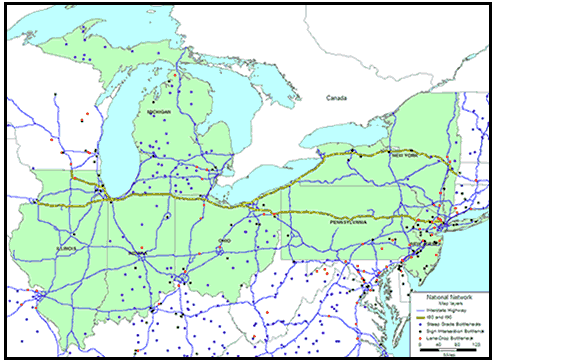
The system strain is most evident at the freeway interchange bottlenecks. On a national basis, and for this corridor, the interchanges represent slightly over half of the annual hours of truck delay. Figure 4-4 shows the location of all the freeway interchange bottlenecks in the corridor. The bottleneck locations are indicated by a solid dot.
| Bottleneck Type Constraint |
Bottleneck Type Roadway |
Bottleneck Type Freight Route |
National Annual Truck Hours of Delay, 2004 (Estimated) |
|---|---|---|---|
| Interchange | Freeway | Urban Freight Corridor | 123,895,000 |
| Subtotal 123,895,000* | |||
| Steep Grade | Arterial | Intercity Freight Corridor | 40,647,000 |
| Steep Grade | Freeway | Intercity Freight Corridor | 23,260,000 |
| Steep Grade | Arterial | Urban Freight Corridor | 1,509,000 |
| Steep Grade | Arterial | Truck Access Route | 303,000 |
| Subtotal 65,718,000‡ | |||
| Signalized Intersection | Arterial | Urban Freight Corridor | 24,977,000 |
| Signalized Intersection | Arterial | Intercity Freight Corridor | 11,148,000 |
| Signalized Intersection | Arterial | Truck Access Route | 6,521,000 |
| Signalized Intersection | Arterial | Intermodal Connector | 468,000 |
| Subtotal 43,113,000‡ | |||
| Lane Drop | Freeway | Intercity Freight Corridor | 5,221,000 |
| Lane Drop | Arterial | Intercity Freight Corridor | 3,694,000 |
| Lane Drop | Arterial | Urban Freight Corridor | 1,665,000 |
| Lane Drop | Arterial | Truck Access Route | 41,000 |
| Lane Drop | Arterial | Intermodal Connector | 3,000 |
| Subtotal 10,622,000‡ | |||
| Total 243,032,000 | |||
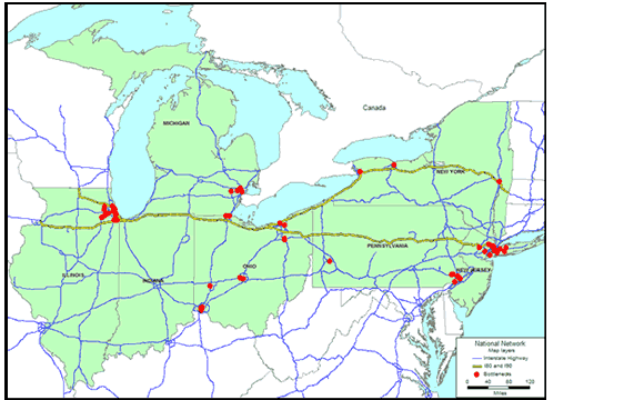
Table 4-4 lists the corridor's top 25 interchange bottlenecks ranked by annual hours of delay for all trucks. The full bottleneck report also contains tables ranked by the percentage of trucks traveling over 500 miles.
Although the highway interchange bottlenecks represent the largest portion of bottleneck congestion, the corridor also contains bottlenecks arising from steep grades, signalized intersections and lane drops. Figure 4-5 focuses the bottleneck locations that arise from these other types of bottlenecks. The steep grade bottlenecks (shown as purple circles) are broadly dispersed throughout the corridor. The signalized intersections and lane drop capacity constraints, like the interchange bottlenecks, are localized around the major metropolitan areas.
| Bottleneck Location |
Bottleneck Urban Area |
Bottleneck Critically Congested Route No. |
Bottleneck No. of Lanes |
All Vehicles AADT |
All Vehicles Daily Minutes of Delay per Vehicle |
All Trucks AADTT |
All Trucks Percent of All Vehicles |
All Trucks Annual Hours of Delay All Trucks |
"Large Trucks Making Longer-Distance Trips" AADTT |
"Large Trucks Making Longer-Distance Trips" Percent of All Trucks |
"Large Trucks Making Longer-Distance Trips" Annual Hours of Delay Large Trucks … |
"Large Trucks Making Longer-Distance Trips" Annual Commodity Tons Large Trucks … |
"Large Trucks Making Longer-Distance Trips" Annual Commodity Value Large Trucks … |
"Large Trucks Making Longer-Distance Trips" Percent Trips Greater Than 500 Miles |
Annual Hours of Delay … Greater Than 500 Miles |
|---|---|---|---|---|---|---|---|---|---|---|---|---|---|---|---|
| I-90 @ I-290 | Buffalo-Niagara Falls | 90 | 4 | 136,500 | 8.3 | 33,100 | 24% | 1,661,900 | 7,300 | 22% | 367,000 | 2,632,500 | $2,968,000 | 58% | 212,900 |
| I-90/94 @ I-290 Interchange ("Circle Interchange") | Chicago-Northwestern IN | 90 | 8 | 305,800 | 9.7 | 26,300 | 9% | 1,544,900 | 9,200 | 35% | 540,400 | 3,718,000 | $4,218,000 | 53% | 286,400 |
| I-94 (Dan Ryan Expwy) @ I-90 Skyway Split (Southside) | Chicago-Northwestern IN | 94 | 8 | 271,700 | 7.9 | 31,600 | 12% | 1,512,900 | 11,100 | 35% | 531,500 | 4,485,900 | $5,089,000 | 53% | 281,700 |
| I-80/I-94 split (southside) | Chicago-Northwestern IN | 80 | 4 | 139,600 | 8.6 | 25,600 | 18% | 1,343,600 | 9,000 | 35% | 472,400 | 3,637,200 | $4,127,000 | 53% | 250,400 |
| Pulaski Rd @ I-55 | Chicago-Northwestern IN | 55 | 6 | 197,200 | 7.5 | 28,700 | 15% | 1,300,400 | 10,000 | 35% | 453,700 | 4,041,300 | $4,585,000 | 53% | 240,500 |
| I-290 @ I-355 | Chicago-Northwestern IN | 290 | 6 | 223,100 | 8.3 | 24,800 | 11% | 1,246,200 | 8,700 | 35% | 437,300 | 3,515,900 | $3,989,000 | 53% | 231,800 |
| I-75 @ I-74 Interchange | Cincinnati (OH-KY) | 75 | 6 | 193,100 | 9.7 | 19,200 | 10% | 1,128,900 | 6,900 | 36% | 405,300 | 2,735,200 | $3,044,000 | 63% | 255,300 |
| SR-315 @ I-70 Interchange | Columbus | 315 | 2 | 64,000 | 8.3 | 21,800 | 34% | 1,097,600 | 5,500 | 25% | 276,500 | 2,180,200 | $2,426,000 | 14% | 38,700 |
| I-270 @I-70 Interchange (West) | Columbus | 270 | 4 | 122,600 | 9.5 | 18,600 | 15% | 1,077,800 | 4,700 | 25% | 271,900 | 1,863,100 | $2,073,000 | 14% | 38,100 |
| I-55 (Stevenson Expwy) @ I-294 Interchnage | Chicago-Northwestern IN | 55 | 6 | 172,600 | 9.6 | 17,200 | 10% | 1,001,600 | 6,000 | 35% | 349,900 | 2,424,800 | $2,751,000 | 53% | 185,400 |
| I-76 @ Girard Av | Philadelphia (PA-NJ) | 76 | 6 | 200,400 | 7.3 | 22,100 | 11% | 982,200 | 5,600 | 26% | 249,200 | 2,133,600 | $2,397,000 | 26% | 64,800 |
| I-71 @ I-70 Interchange | Columbus | 71 | 3 | 112,500 | 8.3 | 19,300 | 17% | 968,800 | 4,900 | 25% | 246,300 | 1,942,400 | $2,162,000 | 14% | 34,500 |
| Darby Paoli Rd @ US-202 | Philadelphia (PA-NJ) | 202 | 4 | 114,200 | 8.3 | 18,900 | 17% | 950,600 | 4,800 | 26% | 241,300 | 1,828,800 | $2,055,000 | 26% | 62,700 |
| I-75 @ US-35 Interchange | Dayton | 75 | 4 | 127,400 | 8.3 | 18,400 | 14% | 923,100 | 7,900 | 43% | 397,100 | 3,131,600 | $3,485,000 | 54% | 214,400 |
| I-70 @US-23 Interchange | Columbus | 70 | 5 | 163,900 | 8.3 | 16,700 | 10% | 839,100 | 4,200 | 25% | 211,100 | 1,664,900 | $1,853,000 | 14% | 29,600 |
| I-57 @ 12th St | Chicago-Northwestern IN | 57 | 6 | 174,200 | 3.8 | 31,600 | 18% | 733,800 | 11,100 | 35% | 257,600 | 4,485,900 | $5,089,000 | 53% | 136,500 |
| I-76 @ SR-77 Interchange+J179 | Akron | 76 | 4 | 122,600 | 8.3 | 14,000 | 11% | 705,200 | 7,000 | 50% | 351,900 | 2,774,800 | $3,088,000 | 52% | 183,000 |
| Southern State Parkway @ Exit 25A | New York-Northeastern NJ | 908 | 6 | 204,500 | 5.4 | 21,400 | 10% | 699,800 | 6,200 | 29% | 203,200 | 2,235,800 | $2,521,000 | 27% | 54,900 |
| I-75 @ I-275 Interchange | Cincinnati (OH-KY) | 75 | 6 | 174,800 | 4.7 | 23,400 | 13% | 662,900 | 8,400 | 36% | 237,800 | 3,095,900 | $3,451,000 | 63% | 149,800 |
| I-278 @ Exit 36 | New York-Northeastern NJ | 278 | 6 | 210,000 | 7.7 | 13,900 | 7% | 654,600 | 4,000 | 29% | 188,200 | 1,442,500 | $1,626,000 | 27% | 50,800 |
| US-1 @ I-95 Interchange | Philadelphia (PA-NJ) | 95 | 8 | 207,800 | 5.7 | 18,600 | 9% | 643,900 | 4,700 | 26% | 162,600 | 1,742,100 | $1,938,000 | 26% | 42,300 |
| I-94 @ I-75 Interchange | Detroit | 94 | 6 | 167,200 | 6.9 | 15,400 | 9% | 643,700 | 4,400 | 29% | 184,200 | 1,597,400 | $1,795,000 | 32% | 58,900 |
| I-90 @I-94 Interchange ("Edens Interchange") | Chicago-Northwestern IN | 90 | 6 | 189,700 | 8.3 | 11,900 | 6% | 596,300 | 4,200 | 35% | 211,100 | 1,697,300 | $1,926,000 | 53% | 111,900 |
| I-278 (Staten Island Expwy) before Verrazano Br | New York-Northeastern NJ | 278 | 6 | 204,400 | 7.3 | 13,300 | 7% | 593,400 | 3,900 | 29% | 173,600 | 1,406,400 | $1,586,000 | 27% | 46,900 |
| I-95 @ Chestnut St | Philadelphia (PA-NJ) | 95 | 6 | 177,000 | 4.7 | 19,600 | 11% | 553,900 | 5,000 | 26% | 141,500 | 1,905,000 | $2,141,000 | 26% | 36,800 |
4.3 Rail, Intermodal, and Water Movements
Unlike highways, there are no publicly available network models currently available to evaluate the capacity of the rail, intermodal, and water modes of freight movements. The discussion of the operational characteristics and capacity of these modes is based on anecdotal information from literature that reflects the current and projected capacities of these modes in handling and transporting freight. As such, the discussion is less specific to the corridor. However, to the maximum extent possible, the discussion focuses on capacity issues that are closely related to freight movement along the corridor. Note that railroads and port are private entities with limited public data on their infrastructure and operations.
4.3.1 Rail Capacity Outlook
Macroeconomic forecasts for 20054 suggest that strong rail freight demand patterns will continue. Shipments of raw materials and finished goods are expected to remain strong as U.S. manufacturing output continues to grow. Coal volumes, which are responsible for approximately 21 percent of the revenue at the top four Class I Railroads, are expected to be robust. Coal demand from electric utilities, in particular, will remain strong due to a growing need for electrical power in the United States, combined with a preference for using coal while natural gas prices remain high. Intermodal volumes, which lately have driven about 18 percent of revenues at the largest Class I Railroads, will also continue to increase, largely due to strong U.S. demand for imported goods and foreign demand for U.S. exports. Demand was also high for other railroad staples such as coal, chemicals, and agricultural products. Adding to railroad demand was a shortage of truck drivers that led to capacity constraints in the trucking industry.
Although the railroads have been adding capacity in 2004 to improve operational efficiency and customer service, it is expected that capacity will continue to remain fairly tight relative to demand in 2005. Against this backdrop of increased demand is a relatively constrained supply of rail capacity.4.3.2 Port and Intermodal Capacity
The growth in container volumes at the Port of New York and New Jersey is accompanied by increased demand for capacity for direct-to-rail movements of international shipping containers. The growth at the port and the railroad can be attributed to several trends in international and domestic shipping. The following are significant trends:
- As global manufacturing consolidates in Asia, more and more goods are being imported into the United States. With congestion growing at West Coast ports, shipping lines are adding more direct services to the East Coast from Asia. Continuing growth in Asian trade boosted container volumes in the Port of New York and New Jersey by 14.6 percent during the first half of 2003. Imports from Far East Asia grew by 38 percent, while imports from Southeast Asia grew by 31 percent. Asian cargo imports, which include furniture, clothing, linens, toys, and lighting products, accounted for 41 percent of all containerized cargo handled by the New York/New Jersey Port in 2003. These cargo volumes make Asia the Port's largest market, surpassing Europe for the first time. Total general cargo increased from 10,195,000 metric tons in the first half of 2002 to 11,582,000 metric tons in 2003, a 13.6-percent increase, according to an analysis of data from the U.S. Census Bureau. General cargo imports increased by 16.8 percent, from 7,195,000 metric tons in the first half of 2002 to 8,404,000 in 2003. General cargo exports increased 5.9 percent, from 3,000,000 in the first half of 2002 to 3,178,000 in 2003.5
- In addition to Asia, the Port of New York and New Jersey also reported significant increases in trade with Latin America, up 19 percent; Africa, up 32 percent; and Australia, up 38 percent. Trade with Europe grew by 3 percent.6
4.4 Highway Safety
Safety is the critical mission of freight operations. There are a mix of factors that influence safe operations: driver performance; roadway design and condition; weather and light conditions; vehicle design; and motor carrier management commitment to safety. This section summarizes the results of the corridors freight operations with respect to safety.
Law enforcement officers within the jurisdiction report crashes on the highway network. Data from these reports are collected and maintained by the National Highway Traffic Safety Administration (NHTSA) in the Fatality Analysis Reporting System (FARS), a census of all crashes involving a fatality, and the General Estimates System (GES), a sample of all law enforcement reported crashes. The Federal Motor Carrier Safety Administration (FMCSA) maintains the Motor Carrier Management Information System (MCMIS), which contains data on truck crashes and for this report, is used to distribute GES truck involved non-fatal crashes to states.
Vehicle types involved in fatal crashes during 2002 are summarized in Table 4-5. Eighty-three percent of vehicles involved in fatal crashes within the corridor States were passenger vehicles, including light weight service/trade vehicles. Large trucks accounted for 7.9 percent, slightly above the national average of 7.8 percent.
| State | Total | Percent Passenger Vehicle |
Percent Motorcycle |
Percent Bus |
Percent Large Truck |
Percent Other/Unknown |
|---|---|---|---|---|---|---|
| Illinois | 1,940 | 83.0 | 5.3 | 0.4 | 8.2 | 3.2 |
| Indiana | 1,157 | 80.7 | 7.7 | 0.1 | 10.4 | 1.1 |
| Michigan | 1,856 | 86.9 | 4.7 | 0.6 | 6.6 | 1.2 |
| Ohio | 2,000 | 81.5 | 7.0 | 0.4 | 9.4 | 1.7 |
| Pennsylvania | 2,198 | 83.6 | 6.2 | 0.6 | 7.9 | 1.6 |
| New York | 2,076 | 81.9 | 7.2 | 1.2 | 6.3 | 3.4 |
| New Jersey | 1,043 | 85.3 | 5.0 | 1.2 | 6.6 | 1.8 |
| Corridor | 12,270 | 83.3 | 6.2 | 0.6 | 7.9 | 2.1 |
| US Total | 58,426 | 83.9 | 5.8 | 0.5 | 7.8 | 2.0 |
To examine the distribution of fatal crashes by highway functional class, Table 4-6 shows the number of all fatal crashes while Table 4-7 shows the number of fatal crashes involving large trucks. The corridor States accounted for 21 percent of the nation's fatal crashes as well as 21 percent of the fatal crashes in which a large truck was involved. However, the highway types on which those crashes occurred vary between the two distributions as well as among the study States.
In the corridor states, 9.3 percent of fatal crashes occurred on interstate highways in 2002, while 12.7 percent of fatal crashes nationwide occurred on interstate highways. Table 4-5 shows a similar absolute difference for fatal crashes involving a large truck – 24.2 of these crashes occurred on interstate highways nationwide, while 21.3 percent occur on interstate highways in the corridor states.
Overall, fatal crash rates are lower in the corridor than the nation as a whole for all fatal crashes as well as for truck involved fatal crashes. Truck involved fatal crash rates in the corridor states are significantly below the national rates for interstate and other principal arterials and somewhat higher than the national rates on minor arterials, collectors and local roads.
| Fatal Crashes | ||||||
|---|---|---|---|---|---|---|
| State | Interstate Highway | Other Principal Arterial | Minor Arterial | Collector | Local Road | Total* |
| Illinois | 171 | 315 | 224 | 212 | 351 | 1,273 |
| Indiana | 60 | 23 | 121 | 170 | 336 | 714 |
| Michigan | 108 | 301 | 219 | 321 | 202 | 1,173 |
| Ohio | 118 | 240 | 218 | 440 | 256 | 1,285 |
| Pennsylvania | 112 | 369 | 350 | 293 | 334 | 1,462 |
| New York | 101 | 465 | 291 | 252 | 295 | 1,411 |
| New Jersey | 79 | 248 | 103 | 89 | 178 | 698 |
| Corridor | 749 | 1,961 | 1,526 | 1,777 | 1,952 | 8,016 |
| US Total | 4,903 | 10,295 | 6,879 | 8,288 | 7,868 | 38,491 |
(ii) VMT data – Highway Statistics, 2002, FHWA State vehicle class VMT estimates.
| Fatal Crash Rate (per 100 Million Vehicle Miles Traveled) | ||||||
|---|---|---|---|---|---|---|
| State | Interstate Highway |
Other Principal Arterial | Minor Arterial | Collector | Local Road | Total* |
| Illinois | 0.563 | 1.181 | 1.079 | 1.431 | 2.746 | 1.208 |
| Indiana | 0.379 | 0.129 | 0.958 | 1.03 | 3.44 | 0.985 |
| Michigan | 0.489 | 0.952 | 1.048 | 1.968 | 2.191 | 1.171 |
| Ohio | 0.38 | 0.974 | 1.29 | 2.581 | 1.404 | 1.191 |
| Pennsylvania | 0.466 | 1.194 | 1.714 | 1.936 | 2.391 | 1.399 |
| New York | 0.399 | 1.222 | 1.026 | 1.121 | 1.563 | 1.06 |
| New Jersey | 0.576 | 0.874 | 0.921 | 1.414 | 1.715 | 0.998 |
| Corridor | 0.461 | 0.99 | 1.164 | 1.637 | 2.094 | 1.156 |
| US Total | 0.712 | 1.203 | 1.334 | 1.988 | 2.075 | 1.348 |
(ii) VMT data – Highway Statistics, 2002, FHWA State vehicle class VMT estimates.
| Number of Crashes Involving Large Trucks | ||||||
|---|---|---|---|---|---|---|
| State | Interstate Highway | Other Principal Arterial | Minor Arterial | Collector | Local Road | Total |
| Illinois | 35 | 48 | 25 | 18 | 16 | 142 |
| Indiana | 21 | 4 | 40 | 27 | 17 | 110 |
| Michigan | 21 | 41 | 30 | 23 | 4 | 120 |
| Ohio | 33 | 51 | 42 | 42 | 13 | 182 |
| Pennsylvania | 37 | 57 | 33 | 19 | 10 | 157 |
| New York | 23 | 45 | 16 | 24 | 15 | 123 |
| New Jersey | 21 | 24 | 5 | 7 | 6 | 63 |
| Corridor | 191 | 270 | 191 | 160 | 81 | 897 |
| US Total | 1,019 | 1,441 | 774 | 642 | 324 | 4,214 |
(ii) VMT data – Highway Statistics, 2002, FHWA State vehicle class VMT estimates.
| Truck Involvement Rate (crashes per 100 Million Vehicle Miles Traveled) | ||||||
|---|---|---|---|---|---|---|
| State | Interstate Highway | Other Principal Arterial | Minor Arterial | Collector | Local Road | Total |
| Illinois | 0.511 | 2.521 | 2.865 | 3.334 | 4.049 | 1.345 |
| Indiana | 0.597 | 0.204 | 4.509 | 2.128 | 1.732 | 1.277 |
| Michigan | 0.928 | 2.106 | 3.848 | 3.811 | 1.134 | 2.018 |
| Ohio | 0.63 | 1.525 | 3.87 | 3.034 | 2.317 | 1.567 |
| Pennsylvania | 0.924 | 3.036 | 3.788 | 2.706 | 1.569 | 1.94 |
| New York | 0.825 | 1.972 | 1.5 | 2.651 | 2.661 | 1.617 |
| New Jersey | 1.636 | 1.41 | 1.083 | 2.728 | 8.883 | 1.67 |
| Corridor | 0.736 | 1.798 | 3.171 | 2.827 | 2.276 | 1.596 |
| US Total | 1.166 | 2.389 | 2.891 | 2.644 | 2.054 | 1.964 |
(ii) VMT data – Highway Statistics, 2002, FHWA State vehicle class VMT estimates.
Table 4-8 shows a summary of all truck involved highway crashes in the corridor. Of the total number of truck involved crashes, 44.2 percent were without casualty, 52.3 percent resulted in injury and 3.5 percent resulted in death. About two percent of the crashes involved a truck hauling hazardous materials in a quantity requiring the truck to be placarded.
| State | Fatal and Non-Fatal Crashes | Fatal Crashes | Non-Fatal Crashes | Injury Crashes | Tow-away Crashes | HM Placard Crashes | Fatalities | Injuries |
|---|---|---|---|---|---|---|---|---|
| Illinois | 3,543 | 159 | 3,384 | 1,598 | 3,385 | 54 | 156 | 2,238 |
| Indiana | 4,402 | 120 | 3,922 | 1,722 | 3,817 | 102 | 131 | 2,424 |
| Michigan | 2,963 | 123 | 2,840 | 2,286 | 1,269 | 26 | 135 | 3,159 |
| Ohio | 4,492 | 189 | 4,303 | 2,859 | 2,854 | 151 | 203 | 4,156 |
| Pennsylvania | 2,192 | 174 | 2,018 | 1,229 | 1,425 | 76 | 174 | 1,748 |
| New York | 3,415 | 131 | 3,284 | 1,534 | 3,180 | 131 | 132 | 2,270 |
| New Jersey | 6,928 | 69 | 6,859 | 3,193 | 6,493 | 0 | 72 | 4,694 |
| Corridor | 27,935 | 965 | 26,610 | 14,421 | 22,423 | 540 | 1,003 | 20,689 |
4.5 Rail Safety
Rail operations in the corridor consist of freight service, intercity passenger service and commuter rail service. The extent of the freight railroad network is described in Chapter 2. Commuter rail, operating primarily on track owned by other railroads, operates approximately 4,000 route miles in the corridor. Amtrak owns and operates about 360 miles in the corridor, primarily in the northeast, as well as operating over freight railroad rights-of-way in other parts of the corridor.
Incidents involving loss of life, injury/illness, or property damage are reported by the railroads to the Federal Railroad Administration. Highway crossing accidents and rail equipment accidents are reported on FRA Forms F-6180.57 and F-6180.54 respectively. Other incidents involving illness or injury not resulting from highway crossing or equipment accidents, primarily railroad workers injured on the job, are reported on FRA Form F-6180.55a. The summary safety statistics reported here do not include incidents reported on the latter form.
Table 4-9 shows the average annual number of highway crossing and rail equipment accidents in the corridor between 2000 and 2004 as well as the average annual number of deaths and injuries associated with these accidents. Table 4-9 shows the distribution of these accidents by train consist type - Freight, Yard/Switching, Passenger and Other.
| State | Highway Crossing Accidents Count |
Highway Crossing Accidents Deaths |
Highway Crossing Accidents Injuries |
Equipment Accidents Count |
Equipment Accidents Deaths |
Equipment Accidents Injuries |
Total Count |
Total Deaths |
Total Injuries |
|---|---|---|---|---|---|---|---|---|---|
| Illinois | 190 | 29 | 74 | 246 | 0 | 40 | 436 | 29 | 113 |
| Indiana | 169 | 21 | 47 | 77 | 0 | 5 | 246 | 21 | 52 |
| Michigan | 107 | 9 | 39 | 37 | 0 | 3 | 144 | 10 | 39 |
| Ohio | 139 | 18 | 39 | 113 | 0 | 4 | 252 | 18 | 44 |
| Pennsylvania | 76 | 4 | 14 | 116 | 0 | 7 | 192 | 5 | 21 |
| New York | 38 | 6 | 13 | 120 | 0 | 31 | 158 | 6 | 44 |
| New Jersey | 40 | 6 | 11 | 70 | 0 | 12 | 110 | 6 | 23 |
| Corridor Total | 759 | 94 | 234 | 779 | 1 | 101 | 1,538 | 95 | 336 |
| US Total | 3,189 | 381 | 1,101 | 3,016 | 10 | 586 | 6,205 | 391 | 1,687 |
From Table 4-9 it can be seen that although highway crossing and equipment accidents each comprise about half of the combined total accidents, the number of casualties is much higher for crossing accidents than equipment accidents. This is expected, as equipment accidents, which are over two-thirds derailments, often do not involve conflict with persons, while highway crossing accidents almost always do.
Table 4-10 indicates that a significant number of highway crossing accidents in the corridor involve consists other than freight trains - including accidents in yard and switching freight service and in passenger service. In states with extensive commuter rail service, Illinois, New Jersey and New York, over one-fifth of highway crossing accidents involve passenger rail service. Each of these states has over 900 route miles in commuter rail service.
| State | Highway Crossing Accidents Freight |
Highway Crossing Accidents Yard/Switch |
Highway Crossing Accidents Passenger |
Highway Crossing Accidents Other |
Equipment Accidents Freight |
Equipment Accidents Yard/Switch |
Equipment Accidents Passenge |
Equipment Accidents Other |
|---|---|---|---|---|---|---|---|---|
| Illinois | 62% | 9% | 21% | 9% | 42% | 39% | 3% | 16% |
| Indiana | 78% | 6% | 10% | 7% | 42% | 35% | 2% | 21% |
| Michigan | 70% | 10% | 9% | 12% | 59% | 30% | 4% | 7% |
| New Jersey | 36% | 16% | 30% | 18% | 14% | 31% | 27% | 27% |
| New York | 61% | 5% | 23% | 12% | 28% | 26% | 29% | 17% |
| Ohio | 83% | 6% | 4% | 7% | 47% | 39% | 1% | 14% |
| Pennsylvania | 78% | 5% | 5% | 11% | 51% | 26% | 15% | 8% |
| Corridor Total | 71% | 8% | 12% | 9% | 40% | 34% | 10% | 16% |
| US Total | 75% | 8% | 8% | 9% | 50% | 31% | 5% | 13% |
4 "Fitch: Healthy Economy Should Fuel U.S. Rail Performance in 2005." http://railforce.com/Rail_Performance.htm.
5 NY/NJ Port Activity Increases During First Half of 2003. PortViews. A newsletter for port tenants and users. Vol. 2, No. 3 December 2003.
6 NY/NJ Port Activity Increases During First Half of 2003. PortViews. A newsletter for port tenants and users. Vol. 2, No. 3 December 2003.