Field Observations and Evaluations of Streambed Scour At Bridges
CHAPTER 2: COMPONENTS OF SCOUR AT BRIDGES
GENERAL
Total scour at a bridge is generally divided into three or more components. According to Richardson and Davis, bridge scour consists of the following three components:(6)
- Aggradation or degradation: long-term changes in streambed elevation due to natural or human-induced causes, which can affect the reach of the river near the bridge.
- Contraction scour: removal of material from the bed and banks across all or most of the channel width, resulting from the contraction of the flow area.
- Local scour: removal of bed material from around piers, abutments, spurs, and embankments. Local scour is caused by the acceleration of flow and by vortices resulting from flow around an obstruction.
Documents from Canada and Australia, along with field experience, indicate the need for a fourth component of scour, termed short-term scour, which refers to natural tendencies of the stream to scour and fill during relatively short-term streamflow runoff cycles.(23,24) Neill calls this component natural scour:"Natural scour in alluvial and tidal channels (is) associated with variations in flow conditions and associated channel processes including bed material transport, bed-form migration, and channel shifting."(p. 77)(23)
Austroads defined this component as follows: "Scour due to river morphology-which would occur naturally in the stream and is a function of flow conditions and associated channel characteristics. It includes general bed movement and scour at channel contractions and bends." (p. 55)(24)
The discussion of contraction scour in Richardson and Davis implies that this natural short-term scour is included in the contraction scour component.(6) This short-term scour does not depend on the contraction, but on the sediment transport processes in the stream. Short-term scour must be accounted for in the analysis of field data, or the reported contraction scour may include short-term scour.
Data to quantify local (abutment and pier) and contraction scour must have a spatial and temporal distribution that encompasses the complex processes causing these types of scour. Scour caused by piers, abutments, and contractions cannot be measured directly, but must be interpreted from channel bathymetry data.(21,25) The spatial and temporal distribution of the data collected must include the data needed to identify the reference surfaces from which the various components of scour are measured. The components of scour cannot be isolated with any degree of certainty without adequate data to identify the reference surfaces.
AGGRADATION AND DEGRADATION
Aggradation and degradation are the result of change in a geomorphic control within the watershed, which in turn causes a long-term change in the streambed elevation. The reference surface for aggradation and degradation must be established at some discrete time in the river's history. Determining the long-term changes at a bridge site is very difficult if historical streamflow data are not available. In such situations, a paleogeomorphologist can evaluate sediment stratigraphy and vegetation to estimate the stability and magnitude of past and future geomorphic changes for a particular river. If streamflow data are available, then the development of specific gage plots, analysis of rating shifts, and analysis of historical changes in streambed elevation are the best means of estimating the stability and magnitude of geomorphic changes. Specific gage plots are developed by selecting one or more discharges to analyze using only measured stage and discharge at each discharge and then plotting a graph of
stage-versus-time for each of the selected discharges. The general slope of the line will indicate the long-term change in the bed elevation, and the irregularity of the line indicates changes in roughness or short-term changes in bed elevation (figure 1). Comparing pre-flood and flood cross sections will not yield the magnitude of long-term streambed elevation change; it does yield a combination of long-term and short-term streambed elevation change, but then only if uncontracted sections (such as the approach section) are used. If the bridge section is used, the difference between pre-flood and flood cross sections will also include contraction scour.
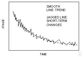
Figure 1. Illustration of a specific gage plot showing stream degradation
SHORT-TERM SCOUR AND FILL
Short-term scour and fill is the change in bed elevation in a reach of river; it is caused by the temporary storage and transport of sediments by the river at different stages of the stream's hydrograph. Depending on the shape of the rising and falling limbs of a hydrograph, the short-term changes in bed elevation may not return to the long-term equilibrium condition at the end of a single event; returning to this equilibrium condition may take more time, perhaps several events. Some streams may never achieve a single equilibrium elevation; however, over a long period of time the specific gage plot should have a horizontal trend indicating no long-term changes (figure 2). Because prediction of short-term scour is difficult, if not impossible, and because the contraction and local scour may override the short-term scour at a structure, bridge scour design guidance has not included this in computations for depth of scour, except as the movement of bed forms.(6)
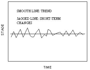
Figure 2. Example of short-term scour and fill with no long-term changes.
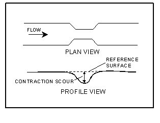
Figure 3. Diagram. Illustration of reference surface
for contraction scour.
If the river is not undergoing long-term changes in streambed elevation, the difference between uncontracted cross-sectional geometry measured before and during the flood provides an estimate of the short-term scour at that location; however, if long-term changes in streambed elevation are occurring on the river, this same measurement would include these long--term changes. These long-term changes cannot be easily removed from the data because long-term geomorphic changes often occur catastrophically at thresholds and not gradually at a uniform rate. A typical value of short-term scour could be estimated from the scatter of the specific gage plot around the long-term trend line (figures 1 and 2).
GENERAL SCOUR
General scour is a combination of short- and long-term scour. General scour at a specific period in time can be measured by determining the difference in bed elevation between pre-flood and flood measurements of uncontracted cross sections; however, measurements of uncontracted cross sections during floods are rarely available. Contracted sections should not be used because the scour measurements based on these sections will include contraction scour, in addition to the short- and long-term scour components.
CONTRACTION SCOUR
Contraction scour results from the contraction of the normal flow by natural contractions or manmade contractions (such as highway embankments and bridge piers); it is the difference in bed elevation between contracted and uncontracted cross sections (figure 3). Contraction scour does not necessarily occur evenly over the entire cross section; however, it usually is defined as the average difference between the contracted and uncontracted sections (figure 4). Contractions can be both lateral and vertical. A vertical contraction would occur when a bridge enters a pressure flow condition. In this report, contraction scour will refer to only lateral contractions, and the term pressure scour will be used to refer to the depth of scour caused by a vertical contraction.
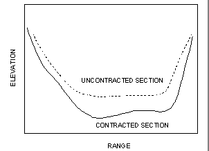
Figure 4. Illustration of nonuniformly distributed contraction scour.
Blodgett reported one of the few field investigations in which contraction scour was quantified separately from aggradation and degradation and short-term scour and fill.(26) Blodgett's contraction scour reference surface was represented by a straight line projected over the contracted section from the thalweg (minimum elevation) profile upstream and downstream from the contracted area. The contraction scour was reported as the difference between this reference surface and the thalweg of the contracted sections; Blodgett stated that using the thalweg to measure contraction scour represented a worst-case condition. Natural pool and riffle sequences must be accounted for when using the thalweg as a reference surface or the results could be misleading. Differences between thalweg elevations may not be consistent with published contraction scour equations, which are based on average changes in the contracted section required to achieve equilibrium sediment transport. Consequently,
these equations cannot be used to compute the lateral distribution of contraction scour.(21)
The reference surface should characterize the mean bed elevation of an uncontracted section near the location of the contraction scour measurement. The reference surface is established by passing a surface through the average elevation of uncontracted cross sections located upstream and downstream from the contracted section.(25) For live bed conditions, the contracted and uncontracted cross sections should ideally be measured concurrently to eliminate effects from aggradation, degradation, and short-term scour. The effects of local scour on the average elevation in the contracted section are removed by excluding the locally scoured areas from the average. The cross section should be subdivided into subareas, based on the mode of transport (live bed transport or clear water conditions) and the scour in each subarea computed using the proper equation for the mode of transport.
Landers and Mueller acknowledged several potential problems with this ideal reference surface for live bed conditions:(25)
- Identification of the bottom width over which active bed-load transport occurs is often difficult because of irregular cross section geometry.
- Upstream and downstream cross sections may be in natural contractions or expansions because of channel bends or other factors, so they do not represent an uncontracted section at the bridge. Alternating pool and riffle sequences in some high-gradient streams can also present problems in establishing an uncontracted reference surface at the bridge.
- Large dune bed forms can produce misleading results when dune crests or troughs predominate in one of the measured sections.
- Slow downstream migration of large sand and gravel bars can make a measurement nonrepresentative of equilibrium conditions.
- Measured contraction scour may not represent equilibrium scour if the scour develops over many years because of the infrequency of channel-formative flows and the resistance of the bed to scour.
- Most flood-flow scour measurements are made only from the bridge deck along the upstream and downstream sides of the bridge because boats are usually unavailable to obtain concurrent uncontracted channel geometry.
Pre-flood and (or) post-flood measurements of uncontracted sections often are used to establish a contraction scour reference surface because of the difficulty in obtaining measurements of the uncontracted sections during a flood. This reference surface is valid for clear water conditions but may not isolate contraction scour from short-term scour and degradation or aggradation for live bed conditions. Pre- and post-flood measurements may be useful for live bed contraction scour measurements if data are sufficient to support the assumption of stable approach and exit sections; however, the stability of the uncontracted sections and the accuracy of the measurement should be assessed by comparing pre- and post-flood measurements throughout the study reach or for multiple floods at a specific location.
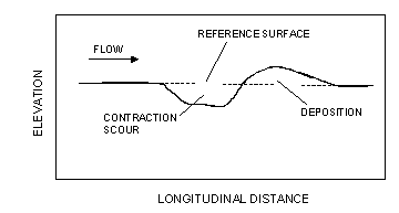
Figure 5. Illustration of a reference surface for clear water contraction scour with material deposited immediately downstream of the scour hole.
For clear water contraction scour, collection of real-time bathymetric data are not necessary. The bed upstream of the bridge and the scour hole will maintain the same geometry after the passage of the flood because no sediment is being transported into the scour hole. Therefore, post-flood surveys can be used to measure clear water contraction scour. The post-flood survey must extend far enough downstream to end beyond the effect of the material that was scoured and deposited downstream (figure 5).
LOCAL SCOUR
Local scour near an obstruction is caused by the vortexes and flow acceleration resulting from flow striking the obstruction and moving past it. The depth of local scour is the difference between where the bed would be if the obstruction were not present and where the bed is with the obstruction in place. The concurrent ambient bed surface is the preferred reference for local scour determinations (figure 6). The concurrent ambient bed surface is determined from data collected at the time the scour hole was measured (concurrent with the scour data). This reference surface is typically taken as the average of several points measured in the vicinity of the obstruction but beyond the limits of the local scour hole.
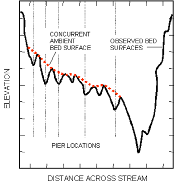
Figure 6. Illustration of reference surface sketched on a cross section plot.
The concept and description of the concurrent ambient bed are simple; however, a representative concurrent ambient bed surface is not always apparent given the range of channel geometries and data limitations. Establishing local scour reference surfaces can be difficult and requires considerable judgment for complex cross section geometries, such as a site where the thalweg coincides with the local scour hole. Additional factors that must be evaluated in measuring local scour include remnant scour holes, debris, scour countermeasures, time-rate of scour, and dune bed forms. Determining a representative and repeatable reference surface for local scour can be difficult.(25) A good method for determining the concurrent ambient bed surface is to use a section of the river that has the same general shape as the bridge section (such as the approach, exit, or preconstruction sections), and move that section vertically until it best fits the bridge section, ignoring the scour holes. The local scour is the difference between the concurrent ambient bed surface and the lowest elevation in the scour hole. Another method is to sketch in the concurrent ambient bed surface (figure 6). Both methods are subjective and may yield different answers when applied by different people to the same cross section.
The concurrent ambient- or mean-equilibrium (for dunes) bed surface has been used as the reference surface in most flume studies of local scour. (See references 9, 27, 28, 29, and 30.) Other reference surfaces used in flume studies include the initial-condition bed surface and the water surface. Field measurements of local scour have generally used the concurrent ambient bed surface as a reference (see references 16, 31, 32, and 33); however, Inglis(34) used the water surface as the reference surface, and Jarrett and Boyle(35) used the highest observed bed elevation at the point where local scour was being measured. Other commonly used references that are not valid for isolating the local scour component include:
- The average bed elevation that includes the local scour hole(s).
- The pre- or post-flood cross sections because the piers and corresponding local scour holes may be present in these cross sections.
- The preconstruction cross section on the bridge plans because this cross section does not reflect the long-term, short-term, and contraction scour that may have occurred.
Local scour measurements based on reference surfaces other than concurrent ambient bed surface may include components of contraction scour, short-term scour, or aggradation or degradation. Total scour measurements recorded with these types of reference surfaces cannot be effectively analyzed in relation to separate local, contraction, and sediment-supply processes; therefore, the concurrent ambient bed surface should be used to determine local scour depths from the channel geometry.(25)
Back to Top
Previous | Table of Contents | Next
| 

