U.S. Department of Transportation
Federal Highway Administration
1200 New Jersey Avenue, SE
Washington, DC 20590
202-366-4000
Federal Highway Administration Research and Technology
Coordinating, Developing, and Delivering Highway Transportation Innovations
 |
| This report is an archived publication and may contain dated technical, contact, and link information |
|
Publication Number: FHWA-RD-01-169
Date: October 2005 |
|||||||||||||||||||||||||||||||||||||||||||||||||||||||||||||||||||||||||||||||||||||||||||||||||||||||||||||||||||||||||||||||||||||||||||||||||||||||||||||||||||||||||||||||||||||||||||||||||||||||||||||||||||||||||||||||||||||||||||||||||||||||||||||||||||||||||||||||||||||||||||||||||||||||||||||||||||||||||||||||||||||||||||||||||||||||||||||||||||||||||||||||||||||||||||||||||||||||||||||||||||||||||||||||||||||||||||||||||||||||||||||||||||||||||||||||||||||||||||||||||||||||||||||||||||||||||||||||||||||||||||||||||||||||||||||||||||||||||||||||||||||||||||||||||||||||||||||||||||||||||||||||||||||||||||||||||||||||||||||||||||||||||||||||||||||||||||||||||||||||||||||||||||||||||||||||||||||||||||||||||||||||||||||||||||||||||||||||||||||||||||||||||||||||||||||||||||||||||||||||||||||||||||||||||||||||||||||||||||||||||||||||||||||||||||||||||||||||||||||||||||||||||||||||||||||||||||||||||||||||||||||||||||||||||||||||||||||||||||||||||||||||||||||||||||||||||||||||||||||||
Rehabilitation of Jointed Portland Cement Concrete Pavements: SPS-6, Initial Evaluation and AnalysisChapter 3. ASSESSMENT OF DATA AVAILABILITY AND COMPLETENESSThe next step in the SPS-6 experiment review and evaluation study is to assess key data availability and completeness. LTPP data availability and quality control (QC) are discussed first. Then, key data elements are assessed for their quality level and completeness. The data reviews are divided into the following categories for presentation:
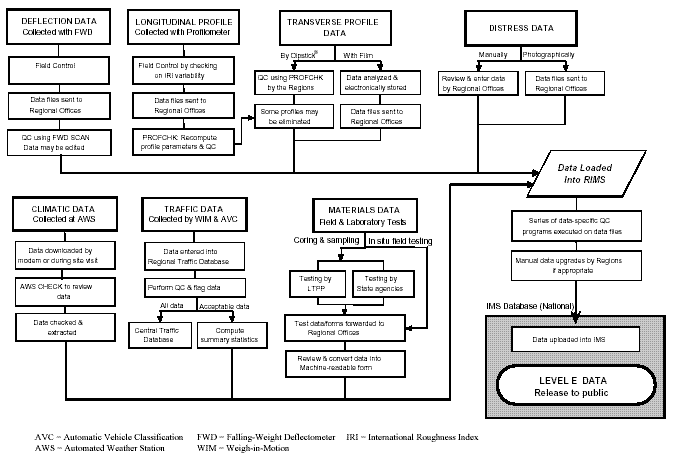
IMS data release 9.8, obtained on August 10, 1999, was used for this study, with the exception of the MON_PROFILE_MASTER table that was obtained on September 12, 1999. In addition, the monitoring data were updated from data obtained from the IMS on February 1, 2000. LTPP DATA AVAILABILITY AND QUALITY CONTROL CHECKSThe quality of the data is the most important factor in any type of analysis. From the outset of the LTPP program, data quality has been considered to be of paramount importance. Procedures for collecting and processing data were defined (and are modified as necessary) to ensure consistency across various reporting contractors, laboratories, equipment operators, etc. Although these procedures formed the foundation of quality control/quality assurance (QC/QA) and data integrity, many more components of a QC/QA plan were necessary to ensure that the data sent to researchers were as error-free as practical. LTPP has developed and implemented an extensive QC program that classifies each of the data elements into categories based on the location of the data in this QC process. Several components or steps that comprise the overall QC/QA plan used on LTPP data are discussed below: 1. Collect Data: Procedures for collecting data are documented for each module in the IMS. These procedures are intended to ensure that data are collected in similar formats, amounts, conditions, etc. Documentation references include the Data Collection Guide for Long-Term Pavement Performance Studies(3) and various module-specific guides. 2. Review Data: Regional engineers review essentially all data input into the regional IMS (RIMS) to check for possible errors related to keystroke input, field operations, procedures, equipment operations, etc. The regional review is intended to catch obvious data collection errors. In addition, some data are preprocessed before they are entered into the IMS. For example, PROFCAL software is used on SHRP profilometers to provide a system check by comparing measurements taken at different speeds. PROFSCAN is a field QA tool that allows an operator to identify invalid data while still in the field, thus saving costly revisits to the site. 3. Load Data in IMS: Some checks are programmed into the IMS to identify errors as data are entered. The IMS contains mandatory, logic, range, data verification, and other miscellaneous checks that are invoked during input. 4. Quality Control/Quality Assurance: Once data are input into the IMS and reviewed by regional engineers, formal QC/QA software programs are run on the data. Level A: Random checks of the data are performed to ensure correct RIMS to IMS data transfer. Level B: A set of dependency checks is performed to ensure that basic essential section information has been recorded in the IMS. In addition, experiment types are verified based on the inventory data. These checks are currently being incorporated into the level E checks for all modules. Level C: A minimal data search is performed for critical elements (e.g., inventory data should contain the coordinates of the section, friction data should contain the skid number, and rehabilitation data should have a code entered to identify each type of work activity). Level D: Expanded range checks are applied to certain fields to identify data element values that fall outside an expected range. These checks are more stringent than the input range checks reviewed by the regional engineers. Level E: Intramodular checks are employed to verify the consistency of the data within a data module (e.g., if an overlay is identified in the inventory layer structure, the data of the overlay should be recorded in the inventory table recording major improvements to the pavement structure). Once the QC/QA programs are completed, the regional engineers review the output and resolve any possible data errors. Often, the data entered are accurate and legitimate, but do not pass a QC/QA check. When this occurs, the regional engineer can document that the data have been confirmed using a comments table in the IMS and manually upgrade the record to level E. Figure 2 provides a flowchart that shows the movement of the data elements and quality checks completed on the data prior to release to the public. Only a fraction of the data fields are checked. A value of "A" is automatically assigned to a record upon entry into the database. A value of "B" indicates that the QC process was executed and a level C check was failed. Any record for which correct section information is stored in the database is available after the quality check has been completed. A record of QC processing is included with the record. Since the checks are run in sequence from A through E, the last successful check is identified on the record as the record status variable. A value of "B" or "C" does not necessarily indicate that a higher level of quality check was unsuccessful, merely that a necessary data element was not available when the quality check was done. There are numerous reasons why some important data may not be available from a publicly released IMS database at the time of analysis. The following are some possible examples: Figure 2. LTPP data collection and data movement flowchart.
As such, the unavailable data identified in this report do not necessarily mean that the data were not collected or submitted by the States. There are several places where data may get held up and not reach level E. Note that the results reported in this report are based on level E status only. The LTPP program is embarking on a systemwide effort to resolve all unavailable data so that they will be available to future researchers. Some data have already been located during the course of this study. GENERAL SITE INFORMATIONThe availability of general site-related information is assessed in this section. This includes site identification, location, report availability, and important dates associated within each SPS-6 site. This information was obtained from a variety of sources, such as the IMS database, construction reports, and deviation reports. It is important that the integrity of all of these sources be assessed. As discussed above, the EXPERIMENT_SECTION table is a key table in the IMS database. This table contains records for all SPS-6 sections. Most of the sections are at level E except for the three sites (Alabama, Missouri (A), and Tennessee) that are at level A. These three States have a level A record status because there are no values available in the BASIC_INFO_RS column. No information relative to these three sites will be released until the record status reaches level E. In addition, all supplemental sections have a record status of "*", indicating that these sections are not subjected to the QC review that the core sections must meet. Therefore, the supplemental sections are only available when requested by that particular State agency. The general SPS-6 site-level information is fundamental to the experiment and is very important to the overall understanding of the sites. Unfortunately, no SPS-6 site information is currently available in the INV_ID table (as of August 1999). This table contains general site information for each site in the experiment, such as the route, county, location, etc. Because no information was available in the SPS_ID table, the information provided in tables 7 and 8 was obtained from the construction reports instead of the SPS_ID table. Tables 7 and 8 list some of the general State information and reports that are available for each site. The construction reports, in combination with the data available in the IMS database, are necessary to fully research this experiment. The ages of the initial construction and rehabilitation are also part of the general information required for analysis of this experiment. The approximate average construction dates for each SPS-6 site are listed in table 9. This table summarizes the construction date of the original (bare) PCC and the date that it was initially opened to traffic. In addition, this table includes the beginning and ending dates of the SPS-6 rehabilitation efforts. If both the beginning and ending rehabilitation dates are not known, then the same date is listed for both the beginning and ending dates. This table shows that the PCC age, based on an August 1, 1999 date, ranges from 20.7 to 41.3 years and that they were rehabilitated between 1 and 10 years ago. Of the 170 SPS-6 sections, only 6 have been deassigned and listed in table 10. Deassigned sections have been removed from the study for various reasons, such as excessive roughness or distress.
N/A= not available *Obtained from construction reports or the LTPP coordinating
office.
CLIMATEThe SPS-6 database contains general environmental weather station data. The general environmental information includes actual measurements from at least one nearby weather station for each LTPP site. In addition, a site-specific statistical estimate based on as many as five nearby weather stations is available. The estimates are called virtual weather stations (VWS) and are stored in the IMS database. The IMS contains monthly and annual summary statistics. Daily data for the VWS are kept offline. General environmental data that are available in the IMS are derived from weather data originally collected from the National Climatic Data Center and the Canadian Climatic Center. The climatic information for each experiment is linked to an associated VWS. Table 11 shows the VWS link associated with each SPS-6 site. Without this link, no climatic data can be associated with the experiment. Currently, there are no climatic links established for Alabama, California, and Missouri (A) at level E or non-level E status.
N/A= not available Based on the virtual weather links associated with each site presented in IMS table CLM_SITE_VWS_LINK, the amount of available data for each VWS, including key temperature and precipitation data, are assessed, as shown in table 12. Each site with a VWS link has 17 to 39 years of climatic data available. In addition, all of the climatic data are at level E status
N/A= not available TRAFFICTraffic data provide estimates of annual vehicle counts by vehicle classification and distribution of axle weight by axle type. The annual traffic summary statistics are stored in the IMS database. Data are supposed to be provided for each year since the road was opened to traffic. With few exceptions (values based on annual average daily traffic (AADT)), the information applies only to the lane being studied. ESALs for loading are estimated based on American Association of State Highway and Transportation Officials (AASHTO) procedures. Traffic data are collected using a combination of permanent and portable equipment by the individual States/Provinces. Table 13 lists the number of years of traffic data stored in the IMS database TRF_MONITOR_BASIC_INFO for each core SPS-6 section. Alabama, Arkansas, Missouri (A), and Tennessee do not have any traffic data in the IMS database. Because these sections are relatively new to the program, they probably have traffic information. However, as of the date of this report, information had not been entered into the database. In addition, Arizona and California have negative ESAL values for most of the AC-overlaid sections and, therefore, have a non-level E record status. By reviewing table 13, several observations about the quantity of the data stored in the IMS can be made:
N/A= not available Annual ESAL Estimate in the LTPP LaneTable TRF_MONITOR_BASIC_INFO was examined to identify SPS-6 records with annual ESAL estimates. No traffic data are stored in the IMS for Alabama, Arkansas, Missouri (A), and Tennessee. For those sites with traffic data, non-zero annual ESAL records were found for all sites. In addition, Arizona and California have negative ESALs, which need to be examined and corrected. PAVEMENT STRUCTURE DATAThe pavement layer data for SPS-6 sections are available from IMS table TST_L05B. This table was examined for the following pavement structure data elements:
Data availability and QC levels for these data elements are summarized in table 14. This table shows that 87 of 111 core sections (78 percent) have PCC slab thickness information at levels A through E, while 85 of 111 sections (77 percent) have information at level E.
As mentioned in chapter 2, there are 112 core SPS-6 sections. Table 14 shows a total of 111 sections. This difference is because the data for section 060601 were not included in the data dump at the time of analysis. It can also be noted that all sections do not have AC overlays. Therefore, there are 70 core and 55 supplemental sections with AC overlays. The following observations are made for the core sections of the SPS-6 experiment. Currently, for levels A through E, 78 to 92 percent of the sections have data in the database for the PCC slab, base layer, and subgrade. When reviewing the percentages of data at level E, 61 to 91 percent of the sections have data at level E. The AC layer has the lowest percentage of level E data, while the subgrade has the highest percentage. In addition, all of the layer information for the Arkansas and Missouri (A) sites is missing from the database, as is some of the layer information for the Alabama site. This is a key table in the IMS database and it is very important that this information be collected and entered in the database as soon as possible. MATERIALS TESTING DATAField and laboratory tests are conducted to establish the material properties and characteristics for LTPP sections. Characterization of the material properties and the variations in these properties among and within the test sections is required to evaluate the causes of performance differences among the test sections. It also provides a basis for improving the models used in pavement design. The material characterization includes the parameters used in current pavement design and mechanical analysis models. The engineering properties are generally required to assess the characteristics and the behavior of the materials. The sampling and testing program is conducted on many different types of materials, such as PCC, AC, asphalt-treated base, cement-treated base, permeable asphalt-treated bases, and unbound granular subbase materials. The sampling and testing requirements for the preconstruction and post-construction laboratory testing plans described in the Specific Pavement Studies Materials Sampling and Testing Requirements for Experiment SPS-6 report were used to determine the minimum testing requirements for each section.(2) The data available from the two IMS data requests (August 1999 and January 2000) were used in the assessment of the sampling and testing program. The results for each site were tabulated and are shown in appendix B. The results for each site are summarized into a single table as shown in table 15. This table summarizes the minimum number of tests required for all core test sections. It also includes the number of materials tests performed for each test and the amount of level E data. The last two columns list the percentages of data at level E and the percentage of the required tests that have been performed. The data in table 15 show that many of the materials tests have nearly 50 percent or more of the results at level E. PAVEMENT MONITORINGPavement monitoring is an ongoing process for all of the SPS-6 sections that are active in the LTPP program. Monitoring activities include profile, falling-weight deflectometer (FWD), faulting, manual distress, 35-mm (1.4-inch) photographic distress surveys (PASCO), rutting, and friction collection. The data within each of these monitoring activities were divided into two distinct categories. The first category includes all levels of data stored in the IMS database (labeled as "All"), and the second category includes only IMS data at level E (labeled as "E only"). Table 16 summarizes the data availability for each SPS-6 site. These values represent the total number of dates that a particular monitoring activity was performed for each section of a given site. For example, for Oklahoma, manual distress data were collected 48 times. This is a summation of all of the manual distress visits to sections 400601 through 400608. Therefore, each section was probably visited once before being rehabilitated and about five times each after construction. Of the 48 visits to the Oklahoma site, 47 visits are at level E status in the IMS database. Based on these values, table 17 summarizes the percentage of data at level E. Table 17 shows that for each monitoring type, 84 to 99 percent of the data in the IMS are available. Manual distress and faulting monitoring collections have the greatest percentages of non-level E data. Over time, it is anticipated that more of these data will be upgraded to level E status as the QC procedure is periodically performed on the database. Table 17 clearly indicates that some of the State sites have very limited amounts of monitoring data in the IMS database, including Alabama, Arkansas, Missouri (A), and Tennessee. The lack of monitoring activities for these States may be partially because of the age of the sections. Some of these experiment sites were constructed close to the time of the preparation of this report and, therefore, data may have been collected that have not yet been entered into the database because of other factors. In addition to the four States mentioned above, California, Pennsylvania, and South Dakota do not have any friction data. However, despite these monitoring deficiencies, it can be seen that most of the data stored in the IMS database are at level E. In other words, most of the States with monitoring activities have 100 percent, or reasonably close to 100 percent, of the data in the database available at level E. More detailed information regarding the specific number of monitoring activities per section is included in appendix C. Appendix C lists the visit dates for each monitoring activity for each section of a site. In addition, the table in appendix C includes the visits for monitoring activities for each of the State supplemental sections.
|
|||||||||||||||||||||||||||||||||||||||||||||||||||||||||||||||||||||||||||||||||||||||||||||||||||||||||||||||||||||||||||||||||||||||||||||||||||||||||||||||||||||||||||||||||||||||||||||||||||||||||||||||||||||||||||||||||||||||||||||||||||||||||||||||||||||||||||||||||||||||||||||||||||||||||||||||||||||||||||||||||||||||||||||||||||||||||||||||||||||||||||||||||||||||||||||||||||||||||||||||||||||||||||||||||||||||||||||||||||||||||||||||||||||||||||||||||||||||||||||||||||||||||||||||||||||||||||||||||||||||||||||||||||||||||||||||||||||||||||||||||||||||||||||||||||||||||||||||||||||||||||||||||||||||||||||||||||||||||||||||||||||||||||||||||||||||||||||||||||||||||||||||||||||||||||||||||||||||||||||||||||||||||||||||||||||||||||||||||||||||||||||||||||||||||||||||||||||||||||||||||||||||||||||||||||||||||||||||||||||||||||||||||||||||||||||||||||||||||||||||||||||||||||||||||||||||||||||||||||||||||||||||||||||||||||||||||||||||||||||||||||||||||||||||||||||||||||||||||||||||