U.S. Department of Transportation
Federal Highway Administration
1200 New Jersey Avenue, SE
Washington, DC 20590
202-366-4000
Federal Highway Administration Research and Technology
Coordinating, Developing, and Delivering Highway Transportation Innovations
 |
| This report is an archived publication and may contain dated technical, contact, and link information |
|
Publication Number: FHWA-HRT-01-167 Date: April 2005 |
The second step in the SPS-2 review and evaluation study is to assess the key data availability and completeness. LTPP data availability and quality control (QC) checks are discussed first. Then, key data elements are assessed for their quality level and completeness. The data reviews are divided into the following categories:
IMS data release 9.8, obtained on August 10, 1999, was used for the majority of the study; however, the distress, profile, and materials testing data are from IMS release 10.1, obtained on February 1, 2000.
The quality of the data is the most important factor in any type of analysis. From the outset of the LTPP program, data quality has been considered of paramount importance. Procedures for collecting and processing data were defined (and are modified as necessary) to ensure consistency across various reporting contractors, laboratories, equipment operators, and so forth. Although these procedures formed the foundation of quality control/quality assurance (QC/QA) and data integrity, many more components of a QC/QA plan were necessary to ensure that the data sent to researchers were as error-free as practical.
LTPP has developed and implemented an extensive QC program that classifies each of the data elements into categories depending upon the location of the data in this QC process. Several components or steps comprise the overall QC/QA plan used on LTPP data, as are discussed in the following paragraphs.
Once the QC/QA programs are completed, the regional engineers review the output and resolve any data errors whenever possible. Often the data entered are accurate and legitimate, but do not pass a QC/QA check. When this occurs, the regional engineer can document that the data have been confirmed using a comments table in the IMS and manually upgrade the record to Level E.
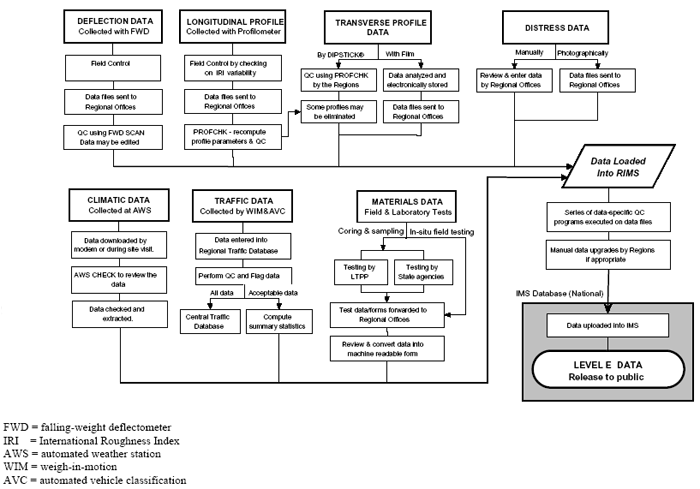
Figure 3 is a flowchart that shows the movement of data elements and quality checks completed on the data prior to release to the public. Only a fraction of the data fields are checked. A value of "A" is automatically assigned to a record on entry in the database. A value of "B" indicates that the QC process was executed and a level C check was failed. Any record for which correct section information is stored in the database is available after the QC is completed. A record of the QC processing is included with the record. Since the checks are run in sequence from A to E, the last successful check is identified on the record as the record status variable. A value of B or C does not necessarily indicate that higher level QC was unsuccessful, merely that a necessary data element was not available when the QC was done.
There are numerous reasons why some important data may not be available from publicly released IMS database at the time of analysis. The following are some possible examples:
As such, the unavailable data identified in this report do not necessarily mean that the data were not collected or submitted by the States. There are several places where data may get held up and not reach level E. Note that the results reported in this report are based upon level E data only.
The LTPP program is embarking on a systemwide effort to resolve all unavailable data so that information will be available to future researchers. Some data have already been located during the course of this study.
General site-related information availability for SPS-2 projects is discussed in this section. This includes site identification and location, key equipment installed, report availability, and important dates associated with each SPS-2 site. The information was obtained from the site construction reports and deviation reports, or from the following IMS tables:
The EXPERIMENT_SECTION table contains records for all the SPS-2 sites and sections. All the site-level records (0200) for the 13 constructed SPS-2 projects are at level E. The section-level records are at level E except for the 12 sections at the newly constructed Wisconsin SPS-2 site. The SPS_ID tables contain records for all 13 SPS-2 sites, and the site data are all at level E.
Since this site-level information is fundamental to the SPS-2 sites and is very important for an overall understanding of the sites, actual key data are presented, in addition to the data availability assessment. General State identification, equipment installation, and report availability information about the SPS-2 sites are provided in table 7. The construction reports were prepared and submitted by LTPP regional coordination office contractors (RCOCs) for all SPS-2 projects.
The site location and functional class information are provided in table 8. Table 9 presents the significant dates such as the approximate construction complete date, traffic opening date, and the LTPP assign and deassign dates. The oldest SPS-2 site is 7.5 years old. As indicated in both tables, all the important site-level information is available for the 13 SPS-2 sites. The only exception is that the approximate construction completion date for the North Dakota site was not available at the time of analysis in the SPS_ID table.
Table 7. SPS-2 site general information and report availability.
| State Information |
Equipment Installed |
Report Availability |
||||||
|---|---|---|---|---|---|---|---|---|
| Abbr. |
Code |
Name |
SHRP Region |
AWS |
WIM |
AVC |
Construction |
Deviation |
| AZ |
04 |
Arizona |
W |
|
|
|
|
- |
| AR |
05 |
Arkansas |
S |
|
|
- |
|
|
| CO |
08 |
Colorado |
W |
|
|
|
- |
|
| DE |
10 |
Delaware |
NA |
|
|
|
|
|
| IA |
19 |
Iowa |
NC |
|
|
|
|
|
| KS |
20 |
Kansas |
NC |
|
|
|
|
|
| MI |
26 |
Michigan |
NC |
|
|
|
|
|
| NV |
32 |
Nevada |
W |
|
|
|
|
- |
| NC |
37 |
North Carolina |
NA |
|
|
|
|
- |
| ND |
38 |
North Dakota |
NC |
|
|
|
|
|
| OH |
39 |
Ohio |
NC |
|
|
|
|
|
| WA |
53 |
Washington |
W |
|
|
|
|
- |
| WI |
55 |
Wisconsin |
NC |
|
|
|
|
|
Notes: NA = North Atlantic Region
NC = North Central Region
S = Southern Region
W = Western Region
Table 8. SPS-2 site location information.
| State |
Route No. |
Lanes |
||
|---|---|---|---|---|
| AZ |
Maricopa |
Interstate 10 |
Rural principal arterial-interstate |
2 |
| AR |
Hot Springs |
Interstate 30 |
Rural principal arterial |
2 |
| CO |
Adams |
Interstate 76 |
Rural principal arterial |
2 |
| DE |
Sussex |
US 113 |
Rural principal arterial-other |
2 |
| IA |
Polk |
US 65 |
Urban principal arterial-other freeways or expressways |
2 |
| KS |
Dickinson |
Interstate 70 |
Rural principal arterial-interstate |
2 |
| MI |
Monroe |
US 23 |
Rural principal arterial-other |
2 |
| NV |
Lander |
Interstate 80 |
Rural principal arterial |
2 |
| NC |
Davidson |
US 52 |
Rural principal arterial-other |
2 |
| ND |
Cass |
Interstate 94 |
Rural principal arterial-interstate |
2 |
| OH |
Delaware |
US 23 |
Rural principal arterial-other |
2 |
| WA |
Adams |
State 395 |
Urban principal arterial-other freeways or expressways |
2 |
| WI |
Marathon |
State 29 |
Rural other principal arterial |
2 |
Table 9. SPS-2 sites significant dates and age as of August 1999.
| State Abbr. |
Age as of August 1999 (years) |
Significant Dates |
|||
|---|---|---|---|---|---|
| Date Completed |
Data Open to Traffic |
Assign Date |
Deassign Date |
||
| AZ |
5.8 |
10/01/93 |
10/01/93 |
01/01/93 |
- |
| AR |
3.8 |
10/01/95 |
11/01/95 |
09/01/93 |
- |
| CO |
5.8 |
10/01/93 |
11/01/93 |
01/01/93 |
- |
| DE |
3.3 |
05/01/96 |
05/01/96 |
01/01/92 |
- |
| IA |
5.0 |
08/01/94 |
12/01/94 |
01/01/92 |
- |
| KS |
7.1 |
07/01/92 |
08/01/92 |
01/01/92 |
- |
| MI |
5.8 |
11/01/93 |
11/01/93 |
01/01/93 |
- |
| NV |
4.0 |
08/01/95 |
09/01/95 |
01/01/93 |
09/18/97 (0202, 0206) |
| NC |
5.1 |
07/01/94 |
07/01/94 |
07/15/92 |
- |
| ND |
4.8 |
11/01/94 |
11/01/94 |
01/01/94 |
- |
| OH |
2.9 |
09/01/96 |
10/01/96 |
01/01/94 |
- |
| WA |
3.8 |
11/01/95 |
11/01/95 |
01/01/93 |
- |
| WI |
1.8 |
10/01/97 |
11/01/97 |
01/01/97 |
- |
Pavement structure data are further divided into two categories: pavement layer data and pavement design features.
Pavement layer data for SPS-2 sections are available from two sources: rod and level measurements (IMS table SPS2_Layer) and core measurements (IMS table TST_L05B). Both tables were examined for the following pavement structure layers:
The data availability and QC levels for these data elements are summarized in table 10.
The TST_L05B table contains records with all layer data for 143 core sections at 12 SPS-2 sites. Layer information from the Wisconsin SPS-2 site is not available from the database at the time of analysis.
The SPS2_LAYER table contains all layer data for all 155 sections from all 13 SPS-2 sites, and 143 sections are at QC level E. The remaining 12 records, all from the same site in Wisconsin, are at level A.
Table 10. Data availability and QC levels for key pavement layer data.
| Data Availability |
TST_L05B |
SPS2_layer |
|||||
|---|---|---|---|---|---|---|---|
| Slab Thickness |
Base Layer |
Subgrade |
Slab Thickness |
Base Layer |
Subgrade |
||
| Core Sections (Total 155 sections) |
|||||||
| At all levels (A to E) |
143 |
143 |
143 |
155 |
155 |
155 |
|
| At level E only |
127 |
108 |
126 |
143 |
143 |
143 |
|
| Percent data at level E |
89 |
82 |
88 |
92 |
92 |
92 |
|
| Core sections missing data at all levels |
12 |
12 |
12 |
0 |
0 |
0 |
|
| Sites with missing data at all levels |
WI |
WI |
WI |
- |
- |
- |
|
| Supplemental Sections (Total 40 Sections) |
|||||||
| Supplemental sections with data |
30 |
26 |
30 |
34 |
33 |
28 |
|
| Supplemental sections missing data |
10 |
14 |
10 |
6 |
7 |
12 |
|
Important general design features, such as drainage, lane width, and shoulder type data, are included in table SPS_GENERAL. The data availability assessment for these data elements is provided in table 11.
Table 11. Data availability for lane width, drainage, and shoulder data for SPS-2 sections.
| Data Availability Number |
Lane Width Data |
Drainage and Shoulder Type Data |
| Core Sections (Total 155 sections) |
||
| At all levels (A to E) |
131 |
131 |
| At level E only |
131 |
131 |
| Percent data at level E |
100 |
100 |
| Core sections missing data at all levels |
24 |
24 |
| Sites with missing data at all levels |
KS, WI |
KS, WI |
| Supplemental Sections (Total 40 Sections) |
||
|---|---|---|
| Supplemental sections with data |
29 |
27 |
| Supplemental sections missing data |
11 |
13 |
As indicated in table 11, information is available for 133 SPS-2 sections, and the data are all at level E. The key design feature data for 24 SPS-2 core sections in Kansas and Wisconsin were not available at the time of analysis.
SPS-2 construction data include information pertaining to the pavement layers constructed according to the requirements stipulated for the experiment. The following key SPS-2 construction tables were evaluated for the data completeness and QC levels:
Data availability assessment and QC levels summary for these tables are provided in tables 12 and 13.
Table 12. Data availability assessment and QC levels for SPS-2 key construction data.
| Data Availability Number |
SPS2_PCC_ |
SPS2_PCC_ |
SPS2_PCC_ |
|---|---|---|---|
| Core Sections (Total 155 sections) |
|||
| At all levels (A to E) |
151 sections (157 records) |
139 sections (175 records) |
155 sections (194 records) |
| At level E only |
136 sections (142 records) |
133 sections (169 records) |
142 sections (181 records) |
| Percent data at level E |
90 |
97 |
93 |
| Core sections missing data at all levels |
4 |
16 |
0 |
| Sites with missing data at all levels |
WA |
AZ, OH |
- |
| Supplemental Sections (Total 40 Sections) |
|||
| Supplemental sections with data |
35 |
21 |
35 |
| Supplemental sections missing data |
5 |
19 |
5 |
Table 13. Data availability assessment and QC levels for other SPS-2 construction data.
| Data Availability Number |
SPS2_PROJECT_ |
SPS2_Subgrade_ |
SPS2_UNBOUND_ |
|---|---|---|---|
| Core Sections (Total 155 sections) |
|||
| At all levels (A to E) |
143 sections |
153 sections |
92 sections (194 records) |
| At level E only |
143 sections |
141 sections |
92 sections (181 records) |
| Percent data at level E |
100 |
92 |
100 |
| Core sections missing data at all levels |
12 |
12 |
12 (only 8 sections at each site) |
| Sites with missing data at all levels |
WI |
WI |
WI |
| Supplemental Sections (Total 40 Sections) |
|||
| Supplemental sections with data |
32 |
34 |
20 |
| Supplemental sections missing data |
8 |
6 |
20 |
Over 90 percent of the existing pavement structure data are at level E, but some data for several SPS-2 core sections were not available at the time of analysis. However, the supplemental sections were missing a lot of data at the time of analysis, as shown in these tables. The Wisconsin SPS-2 site represents most of the missing data, as it was a new site at the time of analysis.
Field and laboratory tests are conducted to establish material properties and characteristics for LTPP sections. Characterization of material properties and the variations in these properties between and within the test sections is required to evaluate causes of performance differences between test sections. The materials characterization includes parameters used in current pavement design and mechanical analysis models.
Material sampling and testing requirements are documented in the SPS-2 Material Sampling and Testing Requirements report.(3) This report includes the development of SPS-2 sampling and testing plans, field material sampling and testing requirements, and laboratory material testing requirements for each SPS-2 site. The SPS-2 material sampling and testing plans for subgrade and bases are provided in table 14, while the material sampling and testing plans for PCC surface are presented in table 15.
The sampling and testing plan specified methods for material sampling and testing at the site level for similar material and structure layers. Therefore, the evaluation of the material testing data should also be conducted at the SPS-2 site level.
Since there is a comprehensive LTPP material data review study underway, only the key data elements for the PCC surface from the SPS-2 sampling and testing plan were evaluated in this study.
Table 14. SPS-2 materials sampling and testing plan for subgrade and bases.
| Material Type and Properties |
LTPP Designation |
LTPP Protocol |
Minimum No. of Tests per Layer |
|---|---|---|---|
| SUBGRADE OR EMBANKMENT Sieve analysis Hydrometer to 0.001 mm Atterberg limits Classification (visual manual only on thin-wall tubes) Moisture-density relations Resilient modulus (if thin-wall tube is not available) Unit weight (if thin-wall tube is not available, test is not conducted) Natural moisture content Unconfined comp. strength (if thin-wall tube is not available, test is not conducted) Permeability Permeability |
SS01 SS02 SS03 SS04 SS05 SS07 SS08 SS09 SS10 SS11 UG09 |
P51 P42 P43 P52 P55 P46 P56 P49 P54 P57 P48 |
6 6 6 6 18 6 6 6 6 6 6 3 6 |
| UNBOUND GRANULAR BASE Particle size analysis Sieve analysis (washed) Atterberg limits Moisture-density relations Resilient modulus Classification Permeability Natural moisture content |
UG01 UG02 UG04 UG05 UG07 UG08 UG09 UG10 |
P41 P41 P43 P44 P46 P47 P48 P49 |
3 3 3 3 3 3 3 3 |
| PERMEABLE-TREATED ASPHALT BASE Asphalt content (extraction) Extracted aggregate: Gradation of aggregate |
AC04 AC04 |
P04 P14 |
3 3 |
| LEAN CONCRETE BASE Compressive strength 7 day 28 day 1 year Core examination and thickness |
PC01 PC06 |
P61 (beams, cores)
P66 |
14 (6, 8) 14 (6, 8) 14 (6, 8)
24 (all cores) |
Table 15. SPS-2 materials sampling and testing plan for the PCC surface.
| PCC Properties |
LTPP Designation |
LTPP Protocol |
Minimum No. of Tests per Layer |
|---|---|---|---|
| Compressive strength 14 day 3.8 MPa 14 day 6.2 MPa 28 day 3.8 MPa 28 day 6.2 MPa 1 year 3.8 MPa 1 year 6.2 MPa |
PC01 |
P61 (beam, cores) |
9 (3, 6) 9 (3, 6) 9 (3, 6) 9 (3, 6) 9 (3, 6) 9 (3, 6) |
| Splitting tensile strength 14 day 3.8 MPa 14 day 6.2 MPa 28 day 3.8 MPa 28 day 6.2 MPa 1 year 3.8 MPa 1 year 6.2 MPa |
PC02 |
P62 (beam, cores) |
9 (3, 6) 9 (3, 6) 9 (3, 6) 9 (3, 6) 9 (3, 6) 9 (3, 6) |
| Coefficient of thermal expansion |
PC03 |
P63 |
2 |
| Static modulus of elasticity 28 day 3.8 MPa 28 day 6.2 MPa 1 year 3.8 MPa 1 year 6.2 MPa |
PC04 |
P64 |
6 6 6 6 |
| PCC unit weight |
PC05 |
P65 |
12 |
| Core examination thickness |
PC06 |
P66 |
98 (all cores) |
| Air content, 28 day |
PC08 |
P68 |
2 |
| Flexural strength 14 day 3.8 MPa 14 day 6.2 MPa 28 day 3.8 MPa 28 day 6.2 MPa 1 year 3.8 MPa 1 year 6.2 MPa |
PC09 |
P69 |
3 3 3 3 3 3 |
For the SPS-2 experiment, the following materials testing tables were evaluated for data availability and completeness:
There are currently no data available on coefficient of thermal expansion for SPS-2 sections; such data are an essential variable for any mechanistic analysis.
The data availability and completeness assessment results for these key PCC materials testing tables are presented in table 16. As shown, 9 of 13 projects have good to excellent data availability for these tables, ranging from 81 to 100 percent tests completed. Three sites-Arkansas, Kansas, and Wisconsin-have a fair amount of PCC testing data available, ranging from 66 to 71 percent. The North Carolina SPS-2 project is missing much PCC testing data at the time of analysis, with only 33 percent available.
Traffic data provide estimates of annual vehicle counts by vehicle classification, and distributions of axle weights by axle type. Annual traffic summary statistics are stored in the IMS traffic module. Data are provided for each year since the road was opened to traffic. With few exceptions (such as annual average daily traffic (AADT)-based values), the information applies only to the lane being studied. Traffic data are collected by the individual States/Provinces using a combination of permanent and portable equipment.
For the SPS-2 experiment, traffic data are generally obtained at the site level. In places where an intersection is located within the test site (thus resulting in different traffic levels on the test sections), measurements of the traffic level on the different groups of sections on each side of the intersection should be obtained. For simplicity and consistency, a traffic data availability assessment is conducted on a section-by-section basis.
The SPS-2 experiment design calls for continuous weigh-in-motion (WIM) monitoring, as permitted by WIM scale operating conditions. Table TRF_MONITOR_BASIC_INFO was examined to identify SPS-2 records containing WIM records, automatic vehicle classifier (AVC) data, and annual ESAL estimates. The WIM and AVC data were further classified into "at least 1 day" and "continuous" monitoring frequency categories. Continuous AVC monitoring was defined as over 300 AVC monitoring days in a given year. Continuous WIM monitoring was defined as over 210 WIM monitoring days in a given year.
Table 17 summarizes the data availability and completeness for SPS-2 traffic data. As shown, very few sections have continuous WIM or AVC monitoring data stored in the IMS database. Non-zero computed annual ESALs were found for 84 core SPS-2 sections at 8 sites with 83 records at level E status. A total of 71 core sections (nearly half of the core sections) have neither WIM monitoring data nor annual ESAL estimates data in the table TRF_MONITOR_BASIC_INFO. Additional annual ESAL estimates were available for 15 supplemental sections located in 6 different States.
Table 16. Data availability assessment for key PCC material testing tables.
| Tables |
TST_PC01 Comp. Strength |
TST_PC02 Split Tensile |
TST_PC09 Flex. Strength |
TST_PC06 Core Exam. |
All |
|||
|---|---|---|---|---|---|---|---|---|
| Min. Req'd* |
Total 27 |
27 |
9 |
98 |
224 |
|||
| Core Section Summary |
702 records (96% at level E) |
613 records (87% at level E) |
282 records (88% at level E) |
1121 (100% at E) |
Avg. % Tests Conducted (% range) |
|||
| States Cells |
3.8 MPa |
6.2 MPa |
3.8 MPa |
6.2 MPa |
3.8 MPa |
6.2 MPa |
All |
|
| AZ |
28 (>100%) |
26 (96%) |
26 (96%) |
28 (>100%) |
9 (100%) |
18 (>100%) |
114 (>100%) |
99% (96 - >100%) |
| AR |
19 (70%) |
18 (67%) |
10 (37%) |
10 (37%) |
15 (>100%) |
6 (67%) |
120 (>100%) |
68% (37 - >100%) |
| CO |
72 (>100%) |
86 (>100%) |
53 (>100%) |
53 (>100%) |
25 (>100%) |
27 (>100%) |
57 (58%) |
94% (58 - >100%) |
| DE |
21 (78%) |
31 (>100%) |
21 (78%) |
26 (96%) |
9 (100%) |
9 (100%) |
82 (84%) |
91% (78 - >100%) |
| IA |
26 (96%) |
25 (93%) |
27 (100%) |
27 (100%) |
9 (100%) |
9 (100%) |
121 (>100%) |
98% (93 - >100%) |
| KS |
19 (70%) |
17 (63%) |
17 (63%) |
17 (63%) |
21 (>100%) |
17 (>100%) |
0 |
66% (0 - >100%) |
| MI |
24 (89%) |
18 (67%) |
23 (85%) |
17 (63%) |
9 (100%) |
7 (78%) |
88 (90%) |
82% (63 - 100%) |
| NV |
27 (100%) |
24 (89%) |
27 (100%) |
24 (89%) |
9 100%) |
9 100%) |
116 (>100%) |
97% (89 - >100%) |
| NC |
7 (26%) |
24 (89%) |
12 44%) |
12 44%) |
2 (22%) |
3 (33%) |
0 |
37% (0 - 89 %) |
| ND |
27 (100%) |
24 (89%) |
14 (52%) |
13 (48%) |
8 (89%) |
8 (89%) |
98 (100%) |
81% (48 - 100%) |
| OH |
26 (96%) |
25 (93%) |
28 (>100%) |
23 (85%) |
9 (100%) |
9 100%) |
125 (>100%) |
96% (93 - >100%) |
| WA |
29 (>100%) |
27 (100%) |
30 (>100%) |
27 (100%) |
12 (>100%) |
9 (100%) |
122 (>100%) |
100% |
| WI |
18 (67%) |
20 (74%) |
18 (67%) |
20 (74%) |
6 (67%) |
8 (89%) |
62 (63%) |
71% (67 - 89%) |
*Note: Min. req'd refers to the minimum number of tests required for the PCC layer.
Table 17. Traffic monitoring data availability assessment for SPS-2 experiment.
| Data Availability |
AVC |
WIM |
With at Least1-Year Annual ESAL Computed |
||
|---|---|---|---|---|---|
| At least 1 day |
Continuous |
At least 1 day |
Continuous |
||
| Core Sections (Total 155 Sections) |
|||||
| At all levels (A to E) |
96 |
37 |
84 |
23 |
84 |
| At level E only |
83 |
12 |
83 |
10 |
83 |
| Percent data at level E |
86 |
32 |
99 |
43 |
99 |
| Core sections missing data at all levels |
59 |
118 |
71 |
132 |
71 |
| Sites with NO data at all levels |
4 |
9 |
5 |
11 |
5 |
| Supplemental Sections (Total 40 Sections) |
|||||
| Supplemental sections with data |
15 |
4 |
15 |
2 |
15 |
| Supplemental sections missing data |
25 |
36 |
25 |
38 |
25 |
There are three types of climatic information: general environmental, automated weather station (AWS), and seasonal monitoring. General environmental and AWS data for the SPS-2 project are obtained at a project or site level.
The general environmental information includes actual measurements from at least one nearby weather station for each LTPP site. In addition, a site-specific statistical estimate based on as many as five nearby weather stations is available. The estimates are called virtual weather stations. The IMS contains monthly and annual summary statistics. Daily data for both the virtual weather stations and actual weather stations are kept offline. General environmental data available in the IMS are derived from weather data originally collected from the National Climatic Data Center and the Canadian Climatic Center.
AWSs have been installed at nearly all of the SPS-2 project sites. The equipment provides site-specific information for the same parameters as the general environmental tables. AWS tables are available with monthly, daily, or hourly statistics.
The availability of both types of climatic data is shown in table 18. As noted, historic climatic data are available for all SPS-2 sites except Wisconsin. AWS data are available for 10 of 13 SPS-2 sites; Arkansas, Delaware, and Wisconsin have no data. The time periods covered by the AWS data at these sites range from 3 to 6 years.
Table 18. SPS-2 climate information availability.
| State |
Age as of August1999 |
General Environment Information, Number of Years with Data |
AWS, Number of Years with Data |
||||
|---|---|---|---|---|---|---|---|
| Temperature |
Precipitation |
Temperature |
Precipitation |
||||
| At All Levels |
At Level E |
At All Levels |
At Level E |
At All Levels |
At Level E |
||
| AZ |
5.8 |
17 |
15 |
17 |
17 |
6 |
6 |
| AR |
3.8 |
17 |
17 |
17 |
17 |
0 |
- |
| CO |
5.8 |
17 |
17 |
17 |
17 |
5 |
5 |
| DE |
3.3 |
17 |
17 |
17 |
17 |
0 |
- |
| IA |
5.0 |
17 |
17 |
17 |
17 |
3 |
3 |
| KS |
7.1 |
17 |
17 |
17 |
17 |
4 |
4 |
| MI |
5.8 |
17 |
17 |
17 |
17 |
3 |
3 |
| NV |
4.0 |
17 |
17 |
17 |
17 |
5 |
5 |
| NC |
5.1 |
17 |
17 |
17 |
17 |
5 |
5 |
| ND |
4.8 |
17 |
17 |
17 |
17 |
5 |
5 |
| OH |
2.9 |
17 |
17 |
17 |
17 |
6 |
6 |
| WA |
3.8 |
17 |
17 |
17 |
17 |
5 |
5 |
| WI |
1.8 |
0 |
0 |
0 |
0 |
0 |
0 |
Seven types of monitoring data are included in the LTPP IMS: automated distress, manual distress, friction, longitudinal profile, cross profile, deflection, and dynamic load response. The monitoring data reviewed for the SPS-2 project are broken into the following categories for discussion:
In this section, the monitoring frequency requirement is discussed first, followed by the data availability and completeness assessment of all the categories.
During the life of these pavement sections, multiple directives have been issued regarding the testing frequency for each type of monitoring data collected. Some of these directives have slightly adjusted the testing intervals during the life of the program. The following is a list of the key documents and directives that affect the monitoring frequency requirement for the SPS-2 project:
1. Data Collection Guide for Long-Term Pavement Performance Studies.(2)
2. LTPP Directive D-02: Quality Assurance of PASCO Products.(4)
3. LTPP Directive D-05: Measurement Frequency and Priorities of Manual Distress Surveys.(5)
4. LTPP Directive FWD-03: Deflection Monitoring Frequency Priorities and Use of FWDs Owned by Other Agencies.(6)
5. LTPP Directive FWD-10: Deflection Monitoring Frequencies and Priorities.(7)
6. LTPP Directive P-02: Profile Monitoring Frequencies and Priorities.(8)
7. LTPP Directive GO-20: Revised Friction Measurement Requirements.(9)
8. LTPP Directive GO-21: LTPP Test Section Monitoring Adjustments.(10)
These directives were used to identify all previous testing frequencies for each type of monitoring data collected, and are summarized in table 19. For supplemental sections, the monitoring frequencies are every 3 years for manual distress and joint faulting monitoring, every 2 years and responsive for photographic survey, and every 5 years and responsive for falling-weight deflectometer (FWD) testing.
Table 19. Testing frequencies for SPS-2 monitoring data collection.
| Data Collection Type |
Postconstruction Monitoring |
Long-Term Monitoring Frequency |
|
|---|---|---|---|
| In Effect Before October 1, 1999 |
In Effect After October 1, 1999 |
||
| Longitudinal profile |
< 6 months is permitted |
Biennially, but may be postponed up to 1 year |
Annually |
| Deflection (for nonfractured PCC) |
< 6 months is permitted |
Biennially and responsive |
Biennially and responsive |
| Manual distress and faulting |
< 3 months |
Biennially, but may be postponed up to 1 year |
Annually |
| Photographic |
Not specified |
- |
Biennially |
| Friction |
<12 months |
Biennially |
Not specified |
In addition, close-out monitoring consisting of FWD, profile, and manual distress surveys should be conducted on each section. According to LTPP Directive GO-21, this monitoring is performed "when it is determined that the test section will be taken out-of-study (due to a construction event or at the option of the highway agency) or at the end of the field monitoring portion of the LTPP program, whichever comes first." (10)
The testing frequency requirements specified in LTPP Directive GO-21 are also listed in the table. This requirement has been in effect since October 1, 1999.
The following IMS monitoring tables are used in evaluating the data availability and completeness for SPS-2 monitoring:
Tables 20 to 24 show summaries of the data availability assessment for longitudinal profile, deflection, faulting, manual, and photographic distress surveys, and friction-monitoring data for SPS-2. Using the minimum monitoring data collection requirement noted in these tables, an assessment of this data availability and completeness follows:
Table 20. Summary of the number of the surveys for longitudinal profile data collection.
| SPS-2 Project in State |
Age as of Aug. 1999 |
No. of Test Visits |
Long-Term Interval, year |
Initial Survey Age, month |
Meet Minimum Requirement? * |
||
|---|---|---|---|---|---|---|---|
| Core Sections |
Suppl. Sections |
||||||
| Avg (min-max) |
% At E |
Avg (min-max) |
Avg (min-max) |
||||
| AZ |
6.3 |
4.9 (4-5) |
100 |
5.0 (5-5) |
1.3 (1-2) |
3.8 (4-4) |
|
| AR |
4.3 |
1.0 (1-1) |
100 |
N/A |
N/A |
16.2 (16-16) |
Not the initial survey |
| CO |
6.3 |
3.0 (3-3) |
100 |
3.0 (3-3) |
2.2 (2-2) |
6.4 (6-6) |
|
| DE |
3.7 |
6.0 (6-6) |
100 |
6.0 (6-6) |
0.3 (0-0) |
7.2 (7-7) |
|
| IA |
5.4 |
4.9 (4-5) |
100 |
5.0 (5-5) |
1.1 (1-1) |
6.5 (7-7) |
|
| KS |
7.5 |
7.9 (7-8) |
100 |
7.0 (7-7) |
0.9 (1-1) |
2.0 (1-8) |
|
| MI |
6.2 |
8.6 (7-9) |
99 |
9.0 (9-9) |
0.6 (1-1) |
10.2 (10-10) |
|
| NV |
4.4 |
3.6 (2-4) |
100 |
4.0 (4-4) |
0.7 (1-1) |
10.9 (11-11) |
|
| NC |
5.5 |
7.9 (7-8) |
100 |
7.5 (7-8) |
0.7 (1-1) |
<0 (-3-3) |
|
| ND |
5.3 |
2.0 (2-2) |
100 |
2.0 (2-2) |
2.0 (2-2) |
31.0 (31-31) |
Not the initial survey |
| OH |
3.3 |
4.0 (4-4) |
100 |
3.4 (3-4) |
0.7 (1-1) |
<0 (-1-1) |
|
| WA |
4.2 |
4.0 (4-4) |
100 |
4.0 (4-4) |
1.2 (1-1) |
0.6 (1-1) |
|
| WI |
2.3 |
3.0 (3-3) |
100 |
3.0 (3-3) |
0.7 (1-1) |
2.0 (2-2) |
|
Note: * Minimum longitudinal profile data collection requirement: Within 12 months for the initial survey, and less than 3 years for all long-term monitoring intervals (i.e., biannually, but may be postponed up to 1 year).
Table 21. Summary of the number of the surveys for deflection data collection.
| SPS-2 Project in State |
Age as of Aug. 1999 |
No. of Test Visits |
Long-Term Interval, year |
Initial Survey Age, month |
Meet Minimum Requirement? * |
||
|---|---|---|---|---|---|---|---|
| Core Sections |
Suppl. Sections |
||||||
| Avg (min-max) |
% At E |
Avg (min-max) |
Avg (min-max) |
||||
| AZ |
6.3 |
6.1 (5-7) |
100 |
2.3 (1-5) |
1.1 (1-1) |
<0 (-2-2) |
|
| AR |
4.3 |
1.5 (1-2) |
100 |
N/A |
0.0 (0-0) |
13.5 (13-14) |
Not the initial survey |
| CO |
6.3 |
4.2 (3-5) |
100 |
3.0 (3-3) |
1.6 (1-2) |
0.5 (-2-6) |
|
| DE |
3.7 |
2.2 (2-3) |
100 |
2.0 (2-2) |
1.2 (1-1) |
0.2 (0-0) |
|
| IA |
5.4 |
1.4 (1-2) |
100 |
1.0 (1-1) |
2.6 (3-3) |
5.3 (3-35) |
OK except for 0219 |
| KS |
7.5 |
5.3 (5-7) |
100 |
2.0 (2-2) |
1.1 (1-1) |
1.1 (1-1) |
|
| MI |
6.2 |
4.2 (3-5) |
100 |
4.0 (4-4) |
1.4 (1-2) |
0.5 (0-1) |
|
| NV |
4.4 |
4.0 (2-6) |
100 |
2.0 (2-2) |
0.7 (0-1) |
<0 (-2-1) |
|
| NC |
5.5 |
2.4 (2-5) |
100 |
2.0 (2-2) |
1.9 (1-2) |
<0 (-2-2) |
|
| ND |
5.3 |
1.3 (1-2) |
100 |
1.3 (1-2) |
0.8 (1-1) |
1.1 (1-1) |
|
| OH |
3.3 |
3.9 (3-5) |
100 |
3.3 (2-4) |
0.6 (0-1) |
<0 (-14--12) |
|
| WA |
4.2 |
4.7 (4-5) |
100 |
4.0 (4-4) |
0.9 (1-1) |
<0 (-4-4) |
|
| WI |
2.3 |
1.0 (1-1) |
0 |
0.9 (0-1) |
N/A |
6.8 (7-7) |
|
Note: * Minimum deflection data collection requirement: Within 12 months for the initial survey, and less than 3 years for all long-term monitoring intervals (i.e., biannually, but may be postponed up to 1 year).
Table 22. Summary of the number of the surveys for faulting data collection.
| SPS-2 Project in State |
Age as of Aug. 1999 |
No. of Test Visits |
Long-Term Interval, year |
Initial Survey Age, month |
Meet Minimum Requirement? * |
||
|---|---|---|---|---|---|---|---|
| Core Sections |
Suppl. Sections |
||||||
| Avg (min-max) |
% At E |
Avg (min-max) |
Avg(min-max) |
||||
| AZ |
6.3 |
2.6 (2-3) |
100 |
2.3 (0-3) |
1.7 (1-2) |
29 (17-49) |
Not the initial survey |
| AR |
4.3 |
1.0 (1-1) |
100 |
N/A |
N/A |
14 (13-14) |
Not the initial survey |
| CO |
6.3 |
3.0 (3-3) |
100 |
3.0 (3-3) |
1.7 (2-2) |
30.8 (31-31) |
Not the initial survey |
| DE |
3.7 |
3.2 (3-4) |
100 |
3.0 (3-3) |
1.5 (1-2) |
0.2 (0-0) |
|
| IA |
5.4 |
2.8 (2-3) |
100 |
2.0 (2-2) |
2.9 (2-5) |
2.6 (3-3) |
|
| KS |
7.5 |
1.9 (1-2) |
100 |
1.0 (1-1) |
4.1 (4-4) |
13.4 (9-59) |
No |
| MI |
6.2 |
4.8 (3-6) |
100 |
4.0 (4-4) |
1.4 (1-1) |
0.5 (0-1) |
|
| NV |
4.4 |
2.2 (2-3) |
100 |
2.0 (2-2) |
2.1 (1-3) |
7.9 (8-8) |
|
| NC |
5.5 |
2.4 (1-6) |
100 |
2.0 (2-2) |
2.6 (1-3) |
2.6 (0-33) |
Not the initial survey for 0204, 0208, 0212 |
| ND |
5.3 |
2.1 (1-3) |
100 |
1.7 (1-2) |
3.9 (2-5) |
0.8 (1-1) |
|
| OH |
3.3 |
2.0 (2-2) |
100 |
2.0 (2-2) |
2.7 (3-3) |
3.4 (3-3) |
|
| WA |
4.2 |
3.0 (3-3) |
100 |
3.0 (3-3) |
1.5 (1-1) |
0.0 (0-0) |
|
| WI |
2.3 |
1.1 (1-2) |
0 |
0.9 (0-1) |
N/A |
6.8 (7-7) |
|
Note: * Minimum faulting data collection requirement: Within 12 months for the initial survey, and less than 3 years for all long-term monitoring intervals (i.e., biannually, but may be postponed up to 1 year).
Table 23. Summary of the number of the surveys for manual and photographic distress data collection.
| SPS-2 Project in State |
Age as of Aug. 1999 |
No. of Test Visits |
Long-Term Interval, year |
Initial Survey Age, month |
Meet Minimum Requirement? * |
||
|---|---|---|---|---|---|---|---|
| Core Sections |
Suppl. Sections |
||||||
| Avg (min-max) |
% At E |
Avg (min-max) |
Avg (min-max) |
||||
| AZ |
6.3 |
3.6 (3-4) |
100 |
3.1 (0-4) |
1.5 (1-2) |
17.2 (17-18) |
Not the initial survey |
| AR |
4.3 |
1.0 (1-1) |
100 |
N/A |
N/A |
13.5 (13-14) |
Not the initial survey |
| CO |
6.3 |
5.1 (5-6) |
100 |
5.0 (5-5) |
1.3 (1-1) |
9.4 (9-9) |
|
| DE |
3.7 |
3.2 (3-4) |
100 |
3.0 (3-3) |
1.5 (1-2) |
0.2 (0-0) |
|
| IA |
5.4 |
3.8 (3-5) |
100 |
3.0 (3-3) |
1.7 (1-2) |
2.6 (3-3) |
|
| KS |
7.5 |
3.8 (3-4) |
100 |
4.0 (4-4) |
1.5 (1-2) |
9.2 (9-9) |
|
| MI |
6.2 |
5.8 (4-7) |
100 |
6.0 (6-6) |
1.1 (1-1) |
0.5 (0-1) |
|
| NV |
4.4 |
3.2 (3-4) |
100 |
3.0 (3-3) |
1.1 (1-1) |
7.9 (8-8) |
|
| NC |
5.5 |
2.5 (2-6) |
100 |
2.0 (2-2) |
1.0 (1-1) |
19.0 (17-19) |
Not the initial survey |
| ND |
5.3 |
3.3 (3-4) |
100 |
3.0 (3-3) |
2.1 (2-2) |
0.8 (1-1) |
|
| OH |
3.3 |
3.0 (3-3) |
100 |
2.6 (2-3) |
1.5 (2-2) |
<0 (0-0) |
|
| WA |
4.2 |
3.0 (3-3) |
100 |
3.0 (3-3) |
1.5 (1-1) |
<0 (0-0) |
|
| WI |
2.3 |
1.0 (1-1) |
0 |
0.9 (0-1) |
N/A |
6.8 (7-7) |
|
Note: * Minimum manual and photographic data collection requirement: Within 12 months for the initial survey, and less than 3 years for all long-term monitoring intervals (i.e., biannually, but may be postponed up to 1 year).
Table 24. Summary of the number of the surveys for friction data collection.
| SPS-2 Project in State |
Age as of Aug. 1999 |
No. of Test Visits |
Long-Term Interval, year |
Initial Survey Age, month |
Meet Minimum Requirement? * |
||
|---|---|---|---|---|---|---|---|
| Core Sections |
Suppl. Sections |
||||||
| Avg (min-max) |
% At E |
Avg (min-max) |
Avg (min-max) |
||||
| AZ |
6.3 |
0 |
- |
- |
- |
- |
No Data |
| AR |
4.3 |
0 |
- |
- |
- |
- |
No Data |
| CO |
6.3 |
1.0 (1-1) |
100 |
1.0 (1-1) |
- |
7.0 (7-7) |
No |
| DE |
3.7 |
0 |
- |
0.0 (0-0) |
- |
- |
No Data |
| IA |
5.4 |
3.0 (3-3) |
100 |
3.0 (3-3) |
1.0 (1-1) |
13.0 (13-13) |
No |
| KS |
7.5 |
2.0 (2-2) |
100 |
2.0 (2-2) |
1.1 (1-1) |
46.0 (46-46) |
No |
| MI |
6.2 |
0.5 (0-1) |
100 |
1.0 (1-1) |
- |
46.8 (47-47) |
No |
| NV |
4.4 |
0 |
- |
0.0 (0-0) |
- |
- |
No Data |
| NC |
5.5 |
0 |
- |
0.0 (0-0) |
- |
- |
No Data |
| ND |
5.3 |
0 |
- |
0.0 (0-0) |
- |
- |
No Data |
| OH |
3.3 |
0 |
- |
0.0 (0-0) |
- |
- |
No Data |
| WA |
4.2 |
2.0 (2-2) |
100 |
2.0 (2-2) |
0.5 (0-1) |
10.5 (6-11) |
|
| WI |
2.3 |
0 |
- |
- |
- |
- |
No Data |
Note: * Minimum friction data collection requirement: Within 12 months for the initial survey, and less than 3 years for all long-term monitoring intervals (i.e., biannually, but may be postponed up to 1 year).
Various PCC pavement sections of the SPS-2 project were selected for measuring pavement response under controlled loading conditions. Both deflections and strains at defined positions within the slab were recorded under loading by known vehicles. Deflections of the PCC surface were measured at six locations (corner, midslab edge, and midslab out wheel path) within two adjacent slabs. The pavement surface strains were measured using surface-mounted strain gauges located at midslab within the wheel path and midslab along the slab edge. Data from a total of 30 traces were obtained from each pass of the loaded vehicle, with multiple repetitions at multiple speeds collected at various times of the day. During the early life of the pavement, dynamic load-response data were collected on a quarterly basis. Data collection was terminated after 2 years.
The dynamic load-response data for PCC sections are stored in the DLR_* module in the following seven IMS tables:
The only dynamic load response data in the IMS database are from the North Carolina and Ohio SPS-2 sites. The data availability assessment of these tables is provided in table 25. All records in these tables are at level E. As shown in the table, significant amounts of stress and strain data are available on the instrumented sections. These data should be very useful for the analysis of the pavement dynamic load responses.
Table 25. Data availability assessment for SPS-2 dynamic load response data.
| Table Name |
Total Records (All at E) |
State |
Records for Each Section |
|||
|---|---|---|---|---|---|---|
| DLR_LVDT_PCC |
880 |
37 |
112 |
112 |
112 |
112 |
| 39 |
96 |
112 |
112 |
112 |
||
| DLR_LVDT_TRACE_SUM_PCC |
39,421 |
37 |
9,089 |
9,106 |
8,146 |
9,954 |
| 39 |
760 |
809 |
810 |
747 |
||
| DLR_MASTER_PCC |
59 |
37 |
8 |
8 |
8 |
8 |
| 39 |
6 |
7 |
7 |
7 |
||
| DLR_STRAIN_CONFIG_PCC |
1,051 |
37 |
128 |
128 |
128 |
127 |
| 39 |
120 |
140 |
140 |
140 |
||
| DLR_STRAIN_TRACE_SUM_PCC |
31,659 |
37 |
7,658 |
8,128 |
6,348 |
8,674 |
| 39 |
199 |
136 |
240 |
276 |
||
| DLR_TEST_MATRIX |
3,350 |
37 |
556 |
681 |
804 |
803 |
| 39 |
108 |
133 |
134 |
131 |
||
| DLR_TRUCK_GEOMETRY |
3 |
37 |
2 Truck load/types |
|||
| 39 |
1 Truck ID/type |
|||||
Table 26 summarizes the data availability and completeness by key data types that are not subject to long-term monitoring, while table 27 summarizes the data availability and completeness for the key data types subject to long-term monitoring. Note that any rating of "fair" or "poor" means that these sites would not meet analysis needs and therefore must be improved as soon as possible. The SPS-2 data deficiencies are summarized below:
A very good percentage of the SPS-2 data are at level E. More than 82 percent of the records are at level E for all data types, with many greater than 99 percent. The availability and completeness of data for the SPS-2 experiment is good overall. However, a significant amount of data was not available at the time of analysis, especially traffic, distress and faulting surveys, and key materials testing data. These deficiencies need to be addressed before serious data analysis can be undertaken. There is an active plan in place to address the deficient materials testing and traffic data.
Table 26. Summary of the SPS-2 data availability and completeness for key data types.
| Type of Data |
SPS-2 Core Sections-Total 13 Sites, 155 Sections |
SPS-2 Supplemental Sections-Total 40 Sections |
|||
|---|---|---|---|---|---|
| No. Sites (Sections) |
% At Level E |
Comments |
|||
| W/ Data |
Missing Data |
||||
| Site information (reports, location, and significant dates data) |
13 sites (155) |
ND-Construction date |
100 |
Excellent |
Excellent-Same as the core sections |
| Key design features (drainage and lane width) |
11 sites (131) |
KS, WI (all 24 sections) |
100 |
Good |
Good-Available for 27 to 29 sections |
| Pavement structure (subgrade layer, base, surface) |
12 sites (143) |
WI |
82-89 |
Good |
Good-Available for 26 to 30 sections |
| SPS-2 construction type data |
11 to 13 (92-155) |
AZ, OH, WA, WI (2 to 16 sections) |
90-100 |
Good |
Good-Available for 20 to 34 sections |
| Key PCC material testing |
9 sites |
AR, KS, NC, and WI |
87-100 |
Fair to good |
Not evaluated |
Table 27. Summary of the SPS-2 data availability and completeness assessment for traffic, climate, and monitoring data types.
|
Monitoring Data Types |
SPS-2 Sites and Core Sections-Total 13 Sites, 155 Sections |
Comments |
||||||
|---|---|---|---|---|---|---|---|---|
|
Initial Survey <12 month |
Long-Term Max. <3 years |
No Data |
% at Level E |
|||||
|
Yes |
No |
Yes |
No |
|||||
| Longitudinal profile |
11 |
AR, ND |
13 |
0 |
- |
99.9 |
Good |
|
| Deflection |
11 |
AR, IA (0219) |
13 |
0 |
- |
86 |
Good |
|
| Faulting |
9 |
AZ, AR, CO, NC (0204, 0208, 0212) |
12 |
KS |
- |
99 |
Fair |
|
| Distress-manual and PASCO |
10 |
AZ, AR, NC |
13 |
0 |
- |
100 |
Fair |
|
| Friction |
2 |
11 sites |
2 |
11 |
8 sites |
92 |
Poor |
|
| Traffic and Climatic Data |
Sites with Data |
No Data |
% At Level E |
Comments |
||||
| Traffic |
Eight sites have at least 1 day of WIM data at 1 year. |
5 sites |
83 |
Poor |
||||
| Climate |
Twelve sites have 17 years of general climatic data. Ten sites have 3 to 6 years of AWS data. |
WI |
>99 |
Excellent |
||||