U.S. Department of Transportation
Federal Highway Administration
1200 New Jersey Avenue, SE
Washington, DC 20590
202-366-4000
Federal Highway Administration Research and Technology
Coordinating, Developing, and Delivering Highway Transportation Innovations
 |
| This report is an archived publication and may contain dated technical, contact, and link information |
|
Publication Number: N/A
Date: November 1996 |
The processed data are contained in binary files that are named 00000xxx.RTD where xxx is the file number from 001 to 999. Each binary processed data file consists of a file header and one or more records as shown in Figure A1. Each record has its own header and a group of 50 data acquisitions at a specific frequency band (one of 41 bands between 285 kHz and 325 kHz). Each data acquisition consists of a data block containing four pieces of data.
Header information consists of various data types which can be accessed by knowing byte location within the particular header. The various data types are described by the following:
| integer: | 2 byte signed integer |
| unsigned integer: | 2 byte unsigned integer |
| float: | 4 byte IEEE floating point value |
| double: | 8 byte IEEE floating point value |
| string: | character string with the number of characters described in the following
explanations. Each character is one byte long. Each string is terminated with a null character (\0). |
The file header contains 25 elements, with total size of 300 bytes, and consists of the following:
| byte location |
description | data type | size (bytes) |
| <0> | records | long int | 4 |
| <4> | bands | int | 2 |
| <6> | band location | int array | 82 (41 integers) |
| <88> | date | string | 10 |
| <98> | description | string | 80 |
| <178> | site | int | 2 |
| <180> | acquisitions per band | int | 2 |
| <182> | min sweep spacing | float | 4 |
| <186> | min repeat spacing | float | 4 |
| <190> | resolution bandwidth for DGPS | float | 4 |
| <194> | video bandwidth for DGPS | float | 4 |
| <198> | span for DGPS | float | 4 |
| <202> | system calibration factor | float | 4 |
| <206> | reference level for noise | float | 4 |
| <210> | spectrum analyzer attenuation | float | 4 |
| <214> | resolution bandwidth for noise | float | 4 |
| <218> | span for noise | float | 4 |
| <222> | external attenuation | float | 4 |
| <226> | reserved double #1 | double | 8 |
| <232> | reserved double #2 | double | 8 |
| <242> | reserved int #1 | double | 8 |
| <244> | reserved int #2 | int | 2 |
| <246> | reserved int #3 | int | 2 |
| <248> | reserved int #4 | int | 2 |
| <250> | reserved string | string | 50 |
| <300> | Start of 1st Record |
Byte location describes the number of bytes from the beginning of the header at which the particular element is located.
1) Records is the number of data records contained in the file.
2) Bands represents the number of different DGPS frequency bands measured.
3) Band Location is an integer array representing the particular frequency bands actually measured. The values are either a 1 or 0 depending on whether the particular frequency band was measured or not, 1 being an affirmative. The actual center frequency of the band can be determined by 285e3 + (1e3 * index), where index = 0.1,2,....40.
4) Date gives the date (UTC time) of the acquisition and is represented in the following format 00/00/00 (month/day/yr).
5) Description is a character string containing a description of the measurement site.
6) Site is a site number that should be correlated with the measurement notes.
7) Acquisitions Per Band is the number of data acquisitions or data blocks within each record (representing a specified frequency band). It also represents the total number of noise data points as described in the record header.
8) Minimum Sweep Spacing represents the minimum possible time in seconds between each data acquisition or data block within a frequency band. In actuality, the time between acquisitions may be longer than this.
9) Minimum Repeat Spacing represents the minimum possible time in minutes between repeat acquisitions within a frequency band as the data acquisition cycles through all the selected frequency bands. In actuality, the recycling time for the frequency band may be longer.
10) Resolution Bandwidth for DGPS is the resolution bandwidth setting in Hz of the HP8563A spectrum analyzer during the measurement of the actual DGPS signal.
11) Video Bandwidth for DGPS is the video bandwidth setting in Hz of the HP8563A spectrum analyzer during the measurement of the actual DGPS signal.
12) Span for DGPS is the frequency span setting in Hz of the HP8563A spectrum analyzer during the measurement of the actual DGPS signal.
13) System Calibration Factor is a calibration correction factor in dB that is added to the measured signal power as determined by the HP8563A spectrum analyzer. The result is that the power level recorded in the data block is the signal power as seen by the front end of the measurement system as it comes out of the antenna.
14) Reference Level for Noise is the reference level setting in dB of the HP8563A spectrum analyzer during the measurement of the noise floor (500 Hz offset from the DGPS signal).
15) Spectrum Analyzer Attenuation is the attenuation setting in dB of the HP8563A spectrum analyzer during the measurement of the actual DGPS signal and the noise floor.
16) Resolution Bandwidth for Noise is the resolution bandwidth setting in Hz of the HP8563A spectrum analyzer during the measurement of the noise floor (500 Hz offset from the DGPS signal). For the type 2 acquisition, the resolution bandwidth is set to 300 Hz.
17) Span for Noise is the frequency span setting in Hz of the HP8563A spectrum analyzer during the measurement of the noise floor (500 Hz offset from the DGPS signal). For the type 2 acquisition, the span is set to zero.
18) External Attenuation is any additional external attenuation in dB in the system not accounted for by the system calibration factor. This is added to the measured power.
19) Reserved Double #1 is a reserved area for a double floating point variable.
20) Reserved Double #2 is a reserved area for a double floating point variable.
21) Reserved Int #1 is a reserved area for an integer variable.
22) Reserved Int #2 is a reserved area for an integer variable.
23) Reserved Int #3 is a reserved area for an integer variable.
24) Reserved Int #4 is a reserved area for an integer variable.
25) Reserved String is a reserved character string.
The record header is located at the beginning of each data record. It has 6 elements, with a total size of 20 bytes, and consists of the following:
| byte location |
description | data type | size (bytes) |
| <0> | frequency band | float | 4 |
| <4> | average noise | float | 4 |
| <8> | standard deviation of noise | float | 4 |
| <12> | peak value of noise | float | 4 |
| <16> | reserved int #1 | int | 2 |
| <18> | reserved int #2 | int | 2 |
| <20> | Beginning of 1st Data Block |
Byte location describes the number of bytes from the beginning of the header at which the particular element is located.
1) Frequency Band is the center frequency in Hz of the band for the data blocks within this record.
2) Average Noise is the average noise power in dB within the resolution bandwidth setting as determined by a single sweep across the frequency span located 500 Hz offset from the center frequency of the DGPS signal in this band.
3) Standard Deviation of Noise is the standard deviation of the noise power in dB within the resolution bandwidth setting as determined by a single sweep across the frequency span located 500 Hz offset from the center frequency of the DGPS signal in this band.
4) Peak Value of Noise is the peak noise power in dB within the resolution bandwidth setting as determined by a single sweep across the frequency span located 500 Hz offset from the center frequency of the DGPS signal in this band.
5) Reserved Int #1 is a reserved area for an integer variable.
6) Reserved Int #2 is a reserved area for an integer variable.
Each data block comprises 4 elements with a total of 62 bytes. There are multiple data blocks within each record, each representing an acquisition within the frequency band. Generally, each acquisition is spaced approximately 1.3 seconds apart. The individual elements of the data block consist of the following:
| byte location |
description | data type | size (bytes) |
| <0> | GPS string | char | 50 |
| <50> | frequency | float | 4 |
| <54> | peak power | float | 4 |
| <58> | field strength | float | 4 |
| <62> | Start of Next Data Block |
Byte location describes the number of bytes from the beginning of the data block at which the particular element is located.
1) GPS string is a character string containing the Trimble ASCII Interface Protocol (TAIP) output from the Trimble Navigation Placer GPS/DR receiver and has the following format:
>RPVAAAAABBBCCCCCDDDDEEEEEFFFGGGHI<
| Field | Significance |
| A | UTC of fix (seconds) |
| B.C | Longitude (in degrees, with decimal minutes: + = N, - = S) |
| D.E | Longitude (in degrees, with decimal minutes: - = W, + = E) |
| F | Speed (mph) |
| G | Heading (0 = N) |
| H | Source (0=2D GPS, 1=3D GPS, 2=2D DGPS, 3=3D DGPS, 6=DR, 8=Degraded DR, 9=Unknown) |
| I | Age of Indicator (2=Fresh, <10 sec; 1=Old, >10 sec; 0=Not available) |
If a particular field is not determined, only >RPV< would appear.
2) Peak Frequency is the frequency in Hz having the greatest power across the frequency span of the acquisition.
3) Peak Power is the power in dBm of the frequency having the greatest power across the frequency span of the acquisition. This value represents the power seen by the front end of the receiver as it comes from the antenna.
4) Field Strength is the field strength in dB microvolts / meter as seen by the receiving antenna. This is calculated from the "Peak Power" value and the antenna correction factor using the following equations.

where GdBi is the gain of the antenna in dBi, fMHz is the frequency in MHz, and ACF is the antenna correction factor in dB;
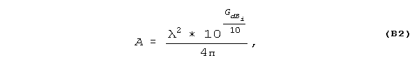
where A is the aperture of the antenna in units of m2, and is the wavelength of the carrier frequency in meters;
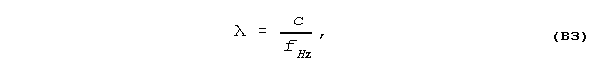
where c is the speed of light in meters per second (3e8 meters per second), and fHz is the carrier frequency in Hz;
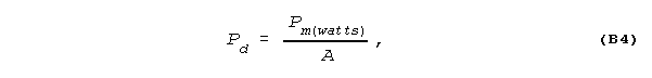
where Pd is the power density in watts per m2, and Pm(watts) is the power in watts measured at the output of the antenna;
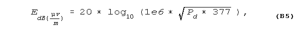
where  is the E field in dB microvolts per meter measured at the antenna, and 377 is the impedance of free space measured in ohms.
To determine the byte location for the header associated with a specific record, use the following formula:
Byte Location = 300 + (r - 1)(20 + (4 * (a * 66))
where:
r = the record number within the data file: 1, 2, 3, ...
a = the number of data blocks acquired within a record (typically 50).
To determine the byte location for a particular data block, use the following formula:
Byte Location = 300 + (r - 1)(20 + (a * 62)) + 20 + (a * 4) + ((d - 1) * 62)
where:
r = the record number within the data file: 1, 2, 3, ...
a = the number of data blocks acquired within a record (typically 50).
d = the number of the particular data block within the record: 1,2,3,....50
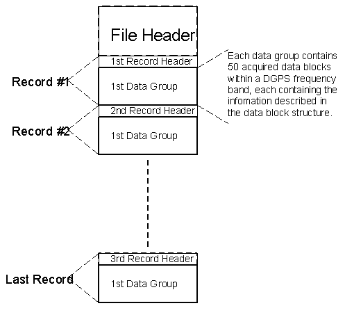
Figure A1. Data File Structure.

