U.S. Department of Transportation
Federal Highway Administration
1200 New Jersey Avenue, SE
Washington, DC 20590
202-366-4000
Federal Highway Administration Research and Technology
Coordinating, Developing, and Delivering Highway Transportation Innovations
 |
| This report is an archived publication and may contain dated technical, contact, and link information |
|
Publication Number: N/A
Date: N/A |
||||||||||||||||||||||||||||||||||||||||||||||||||||||||||||||||||||||||||||||||||||||||||||||||||||||||||||
Report to Congress
|
| ACN | Automated Collision Notification |
| AHS | Automated Highway Systems |
| ARNS | Aeronautical Radio-Navigation Service |
| AVI | Automatic Vehicle Identification |
| AVL | Automatic Vehicle Location |
| C/A | Coarse Acquisition |
| CFIT | Controlled Flight Into Terrain |
| CFIT | Controlled Flight Into Terrain |
| CORS | Continuously Operating Reference Stations |
| DGPS | Differential Global Positioning System |
| DOC |
U.S. Department of Commerce |
| DOD | U.S. Department of Defense |
| DOT | U.S. Department of Transportation |
| FAA | Federal Aviation Administration |
| FHWA | Federal Highway Administration |
| FOC | Full Operational Capability |
| FRA | Federal Railroad Administration |
| FSL | Forecast Systems Laboratory |
| FY | Fiscal Year |
| GIS | Geographic Information System |
| GPS | Global Positioning System |
| GWEN | Ground Wave Emergency Network |
| IGEB | Interagency GPS Executive Board |
| IOC |
Initial Operational Capability |
| ITS |
Intelligent Transportation System |
| JPO |
Joint Program Office |
| MOA |
Memorandum of Agreement |
| NCARC |
National Civil Aviation Review Commission |
| NDGPS |
Nationwide Differential Global Positioning System |
| NOAA |
National Oceanic and Atmospheric Administration |
| NTSB |
National Transportation Safety Board |
| OMB |
Office of Management and Budget |
| PPS |
Precise Positioning Service |
| PTC |
Positive Train Control |
| SPS |
Standard Positioning Service |
| TEA-21 | Transportation Equity Act for the 21st Century |
| TVA | Tennessee Valley Authority |
| USAF | U.S. Air Force |
| WAAS | Wide-Area Augmentation System |
The U.S. Department of Transportation (DOT), in its role as the lead agency within the U.S. Government for all Federal civilian Global Positioning System (GPS) matters, is cooperating with other departments, including the Department of Defense (DOD) and the Department of Commerce (DOC). Together, we are coordinating U.S. Government-provided GPS civilian augmentation systems and improving the basic GPS service to civilian users. As an integral part of these efforts, we fully support the wise and beneficial investments requested by the President for the Nationwide Differential Global Positioning System (NDGPS) and the provision of new civilian GPS signals.
The DOT approach to leadership for these projects is based on requirements. The President’s budget for Fiscal Year (FY) 2000 requests funding for these endeavors solely within the DOT budget. We appreciate the opportunity to provide this information and are confident that this report will aid Congress in making the best choices for America.
NATIONWIDE DIFFERENTIAL GLOBAL POSITIONING SYSTEM (NDGPS)
The U.S. Coast Guard (USCG) announced full operational capability of its Maritime Differential Global Positioning System (DGPS) Service on March 15, 1999. The Coast Guard service provides coastal coverage of the continental United States, the Great Lakes, Puerto Rico, portions of Alaska and Hawaii, and portions of the Mississippi River Basin. Based on this established and proven system, DOT decided to expand the Coast Guard DGPS nationwide. The NDGPS will make available to land users the same benefits currently available to maritime users.
The Federal Railroad Administration (FRA) established the Federal requirement for the NDGPS because of its need for a location determination system for its Positive Train Control (PTC) safety initiative. The NDGPS will also play a role in the national Intelligent Transportation System (ITS) program by helping to improve the effectiveness and efficiency of its services. The NDGPS is also expected to play a part in improving emergency response, improving the planning and processes performed by the State departments of transportation, and improving weather forecasting. The benefits accruing to all modes of transportation are expected to result in improved safety, mobility, economic growth, trade, human and natural environments, and national security. The NDGPS is a multi-agency effort, with seven contributing Federal agencies in three Cabinet-level departments having signed the NDGPS Memorandum of Agreement.
The investment to establish the NDGPS is estimated to be $36.9 million in capital expenses. Following establishment of the system, operation and maintenance of the NDGPS is estimated to be $6.9 million annually. The Federal Railroad Administration (FRA), as the program sponsor and holder of the federal requirement for the NDGPS, requests $10.4 million in the President's Budget for FY 2000.
ADDITIONAL GPS SIGNALS FOR CIVILIAN USE
As a part of the GPS Modernization Program, DOD is working with the civilian community to design a modernized GPS best suited for both military and civilian applications. The GPS is managed by the Interagency GPS Executive Board (IGEB), which is made up of members from all departments and agencies involved in GPS. The IGEB is implementing the White House decision that the modernized GPS will provide the civilian user community with the current coarse-acquisition (C/A) signal around 1575.42 MHz, plus a second C/A signal around 1227.60 MHz, and a third civilian signal around 1176.45 MHz in the frequency band protected for the Aeronautical Radio-Navigation Service (ARNS).
The Federal Aviation Administration (FAA) established the Federal requirement for an additional ARNS-protected GPS signal. This signal will be instrumental in the FAA goal of significantly increasing the safety of global civil aviation by providing precision landings worldwide through satellite navigation.
To realize these benefits, DOT projects a funding requirement of $130 million for FYs 2000 through 2005. The Federal Aviation Administration (FAA), as the program sponsor and holder of the federal requirement, requests $17.0 million in the President's Budget for FY 2000.
CHAPTER 1. NATIONWIDE DIFFERENTIAL
GLOBAL POSITIONING SYSTEM
DESCRIPTION
The Global Positioning System (GPS) is a space-based positioning and navigation system designed to provide worldwide, all-weather, passive, three-dimensional position, velocity, and time data to a variety of civilian and military users. GPS currently provides a Standard Positioning Service (SPS) available to civilian users. However, while GPS offers many advantages over other navigation and positioning services, many applications require better accuracy than is currently provided by SPS. Therefore, the Differential Global Positioning System (DGPS) provides the user with greater accuracy and other GPS information.
The DGPS technique is used to improve the accuracy of the GPS by determining the positioning error at a known location and subsequently transmitting the determined error, or corrective factors, to users of the GPS operating in the same geographical area. In general, DGPS applications can be categorized as either real time or post-processing. Real-time applications receive the broadcasted differential signal and apply the corrections at the time of data collection. The correction process normally occurs in the DGPS receiver and is automatic and transparent to the user. Post-processing applications use a multi-step process. First, GPS data is collected at the measurement site and saved in electronic format. Next, the user returns to an office or facility equipped with software applications and access to the Continuously Operating Reference Stations’ (CORS) archived GPS data files. Finally, the user commences computer calculations to correct the site GPS data using the CORS data.
The U.S. Coast Guard (USCG) established a Maritime DGPS Service for maritime applications. DGPS corrections are broadcast on long-established international marine radio-beacon frequencies (285 to 325 kHz) that are given primary allocation for maritime radio-navigation. The accuracy of the maritime DGPS available to real-time users is published in the Federal Radio-Navigation Plan to be better than 10 meters, although users often experience accuracies of better than 3 meters. CORS offers post-processing users two levels of accuracy: (1) 1 centimeter using the carrier phase and (2) 1 meter using the code range. The U.S. Department of Transportation (DOT) decided to expand the Maritime DGPS Service for land applications and initiated the Nationwide Differential Global Positioning System (NDGPS).
Congressional and Administration Support
Congress authorized the Secretary of Transportation (afterwards known as "the Secretary") to establish, operate, and manage the NDGPS in Section 346 of Public Law 105-66, enacted on October 27, 1997. Along with this authorization, Congress provided FY 1998 appropriations for NDGPS capital expenses to accelerate the project. In the FY 1999 budget, the President included capital and operations funding for the NDGPS. Congress appropriated NDGPS capital expenses, but no specific line item for operations and maintenance was appropriated. For FY 2000, the President requested $10.4 million in the Federal Railroad Administration (FRA) for NDGPS capital expenses ($7.2 million) and operations and maintenance expenses ($3.2 million) necessary to continue the NDGPS project. The FRA is the program sponsor with the Federal requirement for the NDGPS for Positive Train Control (PTC).
Departmental and Agency Support
The Secretary delegated his NDGPS authority to the Commandant of the Coast Guard, the Federal Railroad Administrator, and the Federal Highway Administrator in a Final Rule on February 8, 1999 that was effective on February 17, 1999 (64 Federal Register 7813, February 17, 1999). The Federal Railroad Administrator established the Federal requirement for the NDGPS in her memorandum to the Deputy Secretary on December 8, 1998. In February 1999, an NDGPS Memorandum of Agreement (MOA) was signed by all seven contributing Federal agencies in three Cabinet-level departments. Signatories to the MOA are the Office of the Secretary of Transportation, the Federal Railroad Administration, the National Oceanic and Atmospheric Administration, the U.S. Army Corps of Engineers, the U.S. Coast Guard, the Federal Highway Administration (FHWA), and the U.S. Air Force (USAF). This MOA demonstrates a strong commitment by each of these organizations to the establishment and long-term operation, management, and maintenance of the NDGPS.
In Presidential Decision Directive NSTC-6, U.S. Global Positioning System Policy (March 28, 1996), the President designated DOT as the Nation’s "lead agency for all Federal civil GPS matters." In addition, the President directed DOT to "develop and implement U.S. Government augmentations to the basic GPS for transportation applications." In January 1996, the Coast Guard announced initial operational capability (IOC) for the Maritime DGPS Service, and continued work towards full operational capability (FOC). The maritime DGPS provides coastal coverage of the continental United States, the Great Lakes, Puerto Rico, portions of Alaska and Hawaii, and portions of the Mississippi River Basin. The Coast Guard Maritime DGPS Service is operated in cooperation with the U.S. Army Corps of Engineers and the National Geodetic Survey.
The Technical Report to the Secretary of Transportation on a National Approach to Augmented GPS Services (December 1994) recommended implementation of a Coast Guard-like system for use in land navigation and positioning applications in those sections of the Nation not planned for coverage by the Coast Guard Maritime DGPS Service. DOT found that the most viable GPS augmentation option that could satisfy most surface applications needs is the DGPS operated to the USCG DGPS Navigation Service Broadcast Standard. The Coast Guard DGPS corrections are broadcast in the frequency band of 285 to 325 kHz. This band is given primary spectrum allocation for maritime radio-navigation. In addition, electromagnetic transmissions in this low-/medium-frequency band are well suited for surface-of-the-earth applications since they are less affected by surrounding terrain than higher frequency transmissions.
During its study, DOT learned of Air Force plans to decommission the Ground Wave Emergency Network (GWEN). The GWEN provided emergency communications using 53 transmitter sites located across the continental United States. The GWEN sites operated on frequencies near the Coast Guard DGPS radio-beacon frequencies. During 1997, the Air Force loaned the GWEN site located near Appleton, Washington, to the FRA and the Coast Guard to be converted into a Coast Guard DGPS station as a proof of concept. The Appleton station now provides DGPS coverage to the navigable portions of the Columbia and Snake Rivers and the Positive Train Separation test bed supported by the FRA. Based on the successful results of this prototype, DOT determined that conversion of the GWEN sites to civilian DGPS use provided a cost-avoidance opportunity in the establishment of the NDGPS.
Section 346 of Public Law 105-66 authorized the Secretary to establish, operate, and manage the NDGPS, including taking receipt of necessary GWEN sites and equipment. A coverage plan was developed to meet FRA requirements for use in its train-control initiatives. To complete the required coverage under this plan, three types of station installation were envisioned:
(1) GWEN Conversions — GWEN stations are to be converted to NDGPS stations at their current locations.
(2) GWEN Relocations — NDGPS stations are to be installed using GWEN equipment at new locations chosen for optimum network coverage.
(3) New Sites — NDGPS stations are to be installed using non-GWEN equipment at new locations chosen for optimum network coverage.
DOT plans to install 65 to 75 NDGPS sites. The final NDGPS will have 125 to 135 sites, including the current Coast Guard and U.S. Army Corps of Engineers sites and the sites installed under the NDGPS MOA. These sites will be compatible with, and integrated into, the Maritime DGPS Service, the CORS network of the National Geodetic Survey, and the Integrated Precipitable Water Vapor System of the Forecast Systems Laboratory.
Current and Planned NDGPS Stations
Figure 1 shows the current NDGPS coverage of the United States. Figure 1 illustrates the need for expanded coverage to satisfy the Federal requirement for Positive Train Control.
Figure 2 shows the stations planned to make up the NDGPS by the end of 2002. The final state of the NDGPS is planned to provide double coverage throughout the continental United States as required by the FRA for Positive Train Control. It is also planned to provide Alaska with double coverage of the transportation corridor between Anchorage and Fairbanks and single coverage elsewhere in the State.
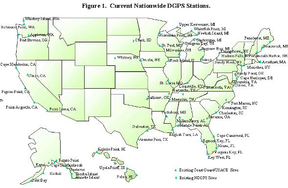
Figure 1. Current NDGPS Stations.
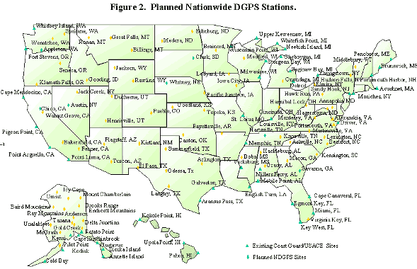
Figure 2. Planned NDGPS Stations.
DOT commissioned a study of costs and benefits of the NDGPS, entitled "NDGPS — Rationale for the Development of an NDGPS Policy and Implementation Plan for a Nationwide DGPS Service." The report for this study was completed in December 1997. It included a cost-benefit analysis performed in accordance with Office of Management and Budget (OMB) Circular A-94 for determining life-cycle benefits. The analysis gave a cost-benefit ratio of 1:140 for the NDGPS. The report estimated the net present value of the cost of the NDGPS to be $78.8 million. The report estimated that the benefit of the NDGPS had a present net value of more than $11.0 billion throughout the 15-year expected life cycle. In the transportation sector (railroads and highways), the value of expected safety and efficiency improvements were estimated to be $8.4 billion. In the nontransportation sector (forestry, agriculture, and environmental management), the value of improvements were estimated to be $2.6 billion.
Implementation of DGPS reference stations in areas not covered by the existing Maritime DGPS Service involves appropriating funds to pay for establishment and operation of the additional sites. The opportunity to establish additional DGPS radio-beacon sites relatively inexpensively is available through the reuse of Air Force decommissioned GWEN sites. As a result, geographic coverage of the current Coast Guard/U.S. Army Corps of Engineers Maritime DGPS Service could be expanded in a shorter time and the cost of providing Nationwide DGPS service would be significantly reduced. New sites, in addition to GWEN sites, are still required in order to establish double coverage nationwide.
Costs can be categorized into two primary components: capital expenses and operating & maintenance costs.
Capital costs are different for GWEN conversions, GWEN relocations, and new sites. A new site is established in a "ground up" manner and includes costs for environmental studies; site selection; site planning; and the procurement, construction, and installation costs of the antenna systems, power systems, communications systems, electronics equipment, equipment shelters, etc. The establishment of a new site using relocated GWEN equipment avoids some of the costs associated with equipment procurement, but will have capital expenditures associated with new site acquisition and equipment relocation. The conversion of an existing GWEN site would avoid some of the capital costs associated with site selection, site planning, and procurement and construction costs since much of the needed installation (e.g., antenna, ground plane, equipment, shelters, and power plant) is already present on the site. The estimated calculated capital costs include the cost of expanding the capability of the existing Coast Guard control stations to monitor the additional Nationwide DGPS radio-beacon sites.
Site operating & maintenance costs include such items as utilities, communications, property leasing, training, and travel, as well as control station staff. Site maintenance costs include the costs for both routine and emergency maintenance of electronic equipment, facilities, and other on-site structures and equipment.
The NDGPS project is expected to
take 5 years to complete (1998 to 2002) at an estimated capital cost of $36.9
million. Once fully implemented, the system is estimated to cost approximately
$6.9 million per year to operate and maintain. The breakdown of capital and
operating & maintenance costs by fiscal year is given in table 1.
Table 1. Estimated Costs of the NDGPS.
Initial Cost Estimates Supporting FRA Budget for NDGPS
(in millions of $)
|
Fiscal Year (FY) |
Capital Costs |
Operating Costs |
|
FY 1998 |
$ 2.4 (Appropriated) |
$ 0.0 (Appropriated) |
|
FY 1999 |
$ 5.5 (Appropriated) |
$ 0.0 (Appropriated) |
|
FY 2000 |
$ 7.2 (Requested) |
$ 3.2 (Requested) |
|
FY 2001& Beyond |
$21.8 (Estimated) |
$ 6.9 (Estimated) |
Total capital costs for FYs 1998
through 2002 are $36.9 million (Estimated).
Annual operating cost is $6.9
million per year (Estimated).
Many other Federal and State organizations see the benefit of the NDGPS service and have offered their support. Examples of this support include:
— Provided space for temporary storage and staging of decommissioned and refurbished GWEN equipment.
— Provided land for the erection of the Hartsville, Tennessee NDGPS broadcast site.
— Performed the necessary environmental analysis to support the implementation at that site.
Discussions are continuing with other organizations concerning potential broadcast sites, environmental analysis, and long-term facility maintenance. We anticipate that as the value of the NDGPS is increasingly understood across the Nation, offers to contribute to its establishment will similarly increase.
Background. Over a recent 7-year period, railroads experienced at least 876 collisions and other accidents that a fully implemented communications-based Positive Train Control (PTC) system would probably have prevented. The National Transportation Safety Board (NTSB) has listed PTC as one of its 10 "Most Wanted" initiatives for national transportation safety.
In July 1994, FRA published a report to Congress, entitled Railroad Communications and Train Control, as required by the Rail Safety Enforcement and Review Act. In that report, FRA outlined an action plan and time line to advance PTC deployment by the end of the century. FRA indicated that in FY 1997, it would commence rulemaking regarding the installation of PTC on identified railroad corridors. That rulemaking has begun and is taking place under the auspices of the Railroad Safety Advisory Committee.
Federal Requirement for the NDGPS. The FRA has a Federal requirement for the Nationwide Differential Global Positioning System (NDGPS). The FRA proposes to facilitate the deployment of PTC by completing the NDGPS network, which the FRA and several railroads consider to be a prerequisite for PTC.
In response to a request from the Senate and House Appropriations Committees accompanying the FY 1994 DOT Appropriations Act, the FRA, in June 1995, published a report to Congress, entitled Differential GPS: An Aid to Positive Train Control. That report concluded that if the Coast Guard’s DGPS service were expanded nationwide, it could satisfy the location determination system requirement for railroad PTC systems. Full nationwide deployment of the Coast Guard DGPS network would enable the development and deployment of PTC systems by providing an affordable, uniform, accurate, real-time location determination system throughout the 48 contiguous States and Alaska. The FRA knows of no other technology foreseeable in the next 10 years that can satisfy this requirement as effectively as the NDGPS.
The NDGPS is essential to railroad Positive Train Control because it will provide a standard nationwide positioning and navigation system with double coverage in order to provide the required availability to the continental United States and portions of Alaska. This system will be compatible with all PTC projects already underway in that it will help solve one of two requirements for PTC interoperability, namely, the need for a common positioning and navigation system for locomotives to operate on railroads anywhere in the Nation. The other is a communications requirement for a common message format and common radio frequencies.
PTC systems requiring NDGPS positioning information are being installed in Alaska, Georgia, Illinois, Michigan, Oregon, Pennsylvania, South Carolina, Virginia, and Washington. Other areas of the country will be considered due to the need to handle growing railroad freight, intermodal, intercity passenger, and commuter rail traffic at higher levels of safety and efficiency. Enabled by the NDGPS, PTC will help reduce transportation collisions and fatalities, reduce travel and shipping times, increase overall transportation system throughput, and reduce transportation operating costs. The Positive Train Control initiative requires the NDGPS and supports its rapid deployment.
The installation and implementation of NDGPS across the continental United States and Alaska directly supports each of the strategic goals of DOT to improve safety, mobility, economic growth and trade, the human and natural environment, and national security. The installation and implementation of NDGPS across the continental United States and Alaska is a key component of the National Science and Technology Council’s "National Intelligent Transportation Infrastructure" initiative, as discussed in its November 1998 Transportation Technology Plan.
National Intelligent Transportation Systems (ITS) Program
The Goals of Congress for ITS Deployment. DOT believes that the NDGPS will play a key role in the Department’s efforts in support of the goals of Congress as expressed in the Transportation Equity Act for the 21st Century (TEA-21). In our national Intelligent Transportation System (ITS) planning, we expect the NDGPS to provide at least single coverage across the country prior to December 31, 2000 and double coverage nationwide before December 31, 2002.
The NDGPS will help the ITS Integration Program achieve its goal to accelerate the integration and interoperability of ITS systems in both metropolitan and rural areas by providing a continuous, standard, accurate GPS augmentation suitable for surface users, including those using ITS applications. The NDGPS will also aid the Commercial Vehicle Intelligent Transportation Infrastructure Deployment Program to improve the safety and productivity of commercial vehicles and drivers, and to reduce the costs associated with commercial vehicle operations. The nationwide nature of the NDGPS will enable multi-State cooperation and corridor development and advance the use of technology to enhance the safe passage of commercial vehicles across the United States.
Description. Intelligent Transportation Systems are broadly described as applying modern command, control, communications, computer, and sensor technologies to the needs of surface transportation. Position location technology is included. ITS applications that will benefit from location information include navigation and route guidance; the management of fleets of vehicles such as trucks, public transit buses, emergency vehicles, snowplows, and maintenance vehicles; and emergency notification (mayday) services.
The Role of DGPS. All of these use GPS as the means of determining the vehicle’s location, and many applications are currently operational with products and services being provided by private sector companies. However, the 1996 Federal Radio-Navigation Plan details the positioning/ navigation accuracy requirements for land-mode radio-navigation system applications. A significant portion of the 30 user services that ITS can provide depends on navigation systems and requires navigation accuracies better than the 100 meters (95 percent of the time) guaranteed by the GPS Standard Positioning Service. These include:
The availability of the NDGPS will undoubtedly cause the manufacturers of ITS products to take advantage of its capabilities. Since the availability of DGPS is likely to improve the real-time performance of location equipment, some manufacturers are likely to employ NDGPS as it becomes available. In addition, DGPS will allow map developers to produce truly accurate maps cheaply and efficiently through improved survey capability. The ITS program will ultimately benefit from the investment in the NDGPS through the improved services and new capabilities of ITS products.
DGPS accuracy is required for the tracking of public transit buses if the system is to perform a "signal priority" function or automatic annunciation of bus stops. Signal priority is the ability of the transit operator to alter the timing of traffic signals to either extend the length of the green phase or reduce the length of the red phase, allowing transit vehicles to better adhere to published schedules. This is accomplished either by a request to the traffic operations agency or with the cooperation of the traffic agency through an automated system. However, in order to accomplish this function, the position of the bus must be known more accurately than the Standard Positioning Service of GPS alone can provide. Thus, all of the transit Automatic Vehicle Location (AVL) systems that require this function have installed a differential station in the metropolitan area, using their existing radio infrastructure to support distribution of the correction signals.
A significant number of ITS user services stand to benefit from the enhanced accuracy, availability, and integrity that NDGPS offers. In many geographic areas, it is not cost-effective for local authorities to install dedicated differential stations. This is particularly true in rural locations or in the transition between metropolitan areas. In these areas, an NDGPS network will act as an enabling technology for ITS applications and will help to ensure the interoperability of systems, at least with regard to navigation and positioning. Navigation and Route Guidance Systems require a means to continuously determine and monitor the vehicle’s location. These systems, when equipped with NDGPS, can determine without ambiguity a vehicle’s location with respect to a junction or a divided highway. This is critical to give the motorist clear routing instructions.
GPS is already finding appropriate uses for Automatic Vehicle Location (AVL) and Automatic Vehicle Identification (AVI) services, such as in commercial fleet management. Virtually all of the products providing AVL include some form of augmentation to the GPS signal. The operations of a trucking firm, a taxi, or a limousine service become more efficient when the dispatch center has a real-time map always available that accurately shows the position of each of its fleet members. The pick-up and delivery service to its clients will potentially be more effective if the location can be determined to the level of accuracy provided by the NDGPS. Likewise, taxi services will probably benefit by more efficient and easier coordination of dispatch functions. Furthermore, to increase effectiveness and efficiency, coordination of fire, paramedic, and police mobile units by means of computer-aided dispatch systems would require the capability for on-board position information that NDGPS will allow. Coordination of roadway maintenance and construction in remote rural areas would also be improved and automated with the positioning aid offered by NDGPS.
Accident or emergency response systems designed to automatically trigger and broadcast mayday messages when a certain event occurs, such as the deployment of a vehicle airbag, are in the development and operational test stages today. The lifesaving impact of these devices may be magnified if the accurate location of the vehicle in distress is also made available. If the mayday system were able to transmit vehicle position accurately to within 10 meters, emergency response crews could be more effectively dispatched to the accident scene. This accuracy will identify the vehicle location to the correct side of a divided highway, perhaps even to the correct lane. Conceivably, this could reduce the response time or number of crews dispatched. Rather than sending response teams from both the northbound and southbound exits, only one could be dispatched.
In Spring 1997, 18 ITS stakeholders, including automobile manufacturers, in-vehicle navigation and route guidance hardware suppliers, AVL system providers, and in-vehicle equipment operating/processing software vendors, were asked about their potential need for DGPS in ITS applications, primarily for navigation and route guidance systems. At that time, they responded that for navigation and route planning, a hybrid of GPS augmented with map matching or dead reckoning was the best choice and that DGPS would offer no additional benefits over GPS. During more recent informal discussions, at least one manufacturer has indicated that the use of NDGPS may reduce the complexity of their systems, improving reliability and accuracy, and reducing cost. DOT believes that as the capabilities of the NDGPS are increasingly available across the country, they will become better understood and better supported by those involved in ITS applications.
Conclusion. Many ITS products and services do not require NDGPS to perform their functions at the current levels of efficiency and effectiveness. However, DOT believes the availability of the NDGPS system will cause the manufacturers of ITS products to find ways to take advantage of its capability to improve service and offer new capabilities within their products. The accuracy, availability, and integrity of the NDGPS will clearly enhance the capabilities of numerous ITS applications. This is especially true in rural areas and in those metropolitan areas where DGPS has not yet been established. We expect the incremental benefits of DGPS over GPS or other positioning services to result in a reduction in lives lost (due to improved emergency response) and a general increase in transportation efficiency (through improved vehicle control and coordination). The ITS program will ultimately benefit from the investment in the NDGPS and will support its rapid deployment.
Response to Vehicle Crashes and Emergencies
Unfortunately, the information requested by the Congress on the "actual number of highway crashes in which emergency responders are substantially delayed because of an inability to obtain exact crash locations" is not currently available. However, the National Highway Traffic Safety Administration is currently conducting an operational test called Automated Collision Notification (ACN), which is to be finalized and the results made available in late 1999. Vehicles configured with ACN automatically emit a distress call and furnish positioning information when an airbag is deployed. It is hoped that the test will provide more definitive information as to the benefit to crash victims of providing location information at the instance of a crash.
Emergency response services must find the person in distress quickly to render effective emergency care. Emergency management services, such as fire, ambulance, and police, use Automatic Vehicle Location (AVL) and computer-aided dispatching systems to guide their emergency vehicles to incident locations. These systems help dispatchers identify the closest unit to the scene based on location, as well as on the best route. This helps to decrease response time. Navigation of emergency service vehicles in remote areas has the potential to benefit from the NDGPS. Locating addresses in remote areas can often be very difficult, and use of in-vehicle navigation could significantly reduce the time it takes to respond to emergency calls.
The availability of an accurate and compatible mapping system is one critical aspect of the emergency response process. The accurate Geographic Information System (GIS) mapping of highway systems is in progress in several States, such as Montana, South Dakota, Tennessee, and Texas. The requirement for post-processing of data to make these maps accurate significantly increases the time required for the process, especially considering the large volume of data to be gathered. The mapping function for secondary and county roads is an additional problem since these roads are frequently not equipped with mile markers as are the State primary and Interstate road systems. The accurate, real-time capabilities of the NDGPS are expected to benefit from the accurate mapping of road and highway systems.
Rural areas have the potential to benefit the most from GPS/DGPS technology to locate and assist persons with medical needs. Fifty-six percent of all fatal accidents occur on rural roads, with only 11 percent of these fatalities occurring on Interstates. The NDGPS will provide a method of achieving timely responses in case of emergency. The response time for accidents in rural areas is significantly higher than for accidents in urban areas.
The inherent low cost and universal coverage of NDGPS technology gives it a great advantage over other high-infrastructure-cost locating solutions. It can be incorporated with wireless technology and sensors to allow earlier notification of injury, which means shorter response times. "The sooner rescue services can initiate treatment and deliver these patients to an emergency department, the better the patients’ chance of survival. The ‘golden hour of trauma’ is a phrase used to refer to the first hour after a traumatic injury is sustained. Injured persons delivered to an emergency department during this period have the best chance of survival."
State Departments of Transportation
Numerous State and local transportation departments are already utilizing DGPS technology, while others are in the process of evaluating it for their specific application requirements. There are several efficiency and effectiveness incentives for transportation departments to utilize this evolving technology. There are many State transportation applications that will benefit from NDGPS. Such applications include:
To date, 21 State representatives have provided a description of their DGPS-related activities and applications. These States include Arizona, Colorado, Florida, Indiana, Iowa, Kansas, Louisiana, Michigan, Minnesota, Montana, Nevada, New Hampshire, New York, North Dakota, Oregon, South Dakota, Tennessee, Texas, Utah, Virginia, and Wisconsin.
Congress included in Section 346 of Public Law 105-66 the directive to DOT to "investigate the use of the NDGPS reference stations for the Global Positioning System Integrated Precipitable Water Vapor System of the National Oceanic and Atmospheric Administration." This investigation is being conducted in cooperation with NOAA’s Forecast Systems Laboratory (FSL). Although a final evaluation has not yet been made, the FSL reports very favorable initial results. The reports of these investigations are available on the FSL Web Site at:
http://ipwdev.fsl.noaa.gov/www-dd/gps_web/reports.html.
CHAPTER 2. GPS MODERNIZATION — NEW CIVILIAN GPS SIGNALS
The Global Positioning System (GPS) provides a Standard Positioning Service (SPS) to all users and a Precise Positioning Service (PPS) to authorized users. As part of the SPS, a coarse-acquisition (C/A) signal is broadcast in the L1 frequency band centered around 1575.42 MHz. The C/A signal is often referred to as the "civilian" signal. As part of the PPS, an encrypted signal is broadcast in the L1 band along with the C/A signal, and a second encrypted signal is broadcast in the L2 band centered around 1227.60 MHz. These are often referred to as the "military" signals. Currently, there is no C/A signal in the L2 band.
The GPS was designed as a dual-use system with the primary purpose of enhancing the effectiveness of U.S. and allied military forces. GPS is also rapidly becoming an integral component of many important infrastructures that are not solely military in nature, such as international air traffic management. The military and civilian communities are cooperating in a modernization program for the GPS with the goal of enhancing the capability of the GPS for both military and non-military applications. DOT is the lead agency within the U.S. Government for all Federal civilian GPS matters. This includes serving as co-chair of the permanent Interagency GPS Executive Board (IGEB), which manages the GPS and its augmentations.
The addition of new civilian signals to the GPS will significantly improve the robustness and reliability of GPS services to civilian users. This will enable unprecedented real-time determination of worldwide, all-weather, passive, three-dimensional position, velocity, and time data. The modernized GPS will spur new applications, further expanding the rapidly growing market for GPS equipment and services worldwide and strengthening U.S. leadership in this industry.
For FY 1999, FHWA requested $4,154,000 to continue DOT work supporting time-critical decisions necessary to provide an alternative civilian signal (often referred to as the L5 band) as part of the Air Force’s GPS modernization program. Congress denied the FY 1999 FHWA request. The House and Senate Transportation Appropriations Subcommittees included in their reports the following directive concerning an alternate civilian GPS signal:
The Department is directed to submit a report to the House and Senate Committees on Appropriations as part of the FY 2000 budget justification identifying the long-term costs, benefits, and cost sharing that might be reasonably expected for both DGPS and the L5. The likely financial role of the States, other Federal agencies, and the private sector in those systems should be clearly specified in terms of expected cash and in-kind contributions.
For the FY 2000 budget, DOT is requesting funding of the DOT contribution to GPS modernization in the budget of the Federal Aviation Administration (FAA). The following table gives initial cost estimates for GPS modernization over the next 6 years.
Table 2. Estimated Costs of the New Civilian GPS Signals.
Initial Civilian-Share
Cost Estimates for GPS Modernization
(in
millions of $)
|
Activity Supported |
FY00 | FY01 through FY05 |
| New Civilian Signal at 1227.60 MHz | 2.7 | 26.4 |
| New Civilian Signal at 1176.45 MHz | 11.3 | 70.1 |
| Management & Technical Support | 3.2 | 16.4 |
| Total Next 6 Years = $130.1 | 17.2 | 112.9 |
Notes:
(1) A current GPS Joint Program
Office (JPO)/FAA study will more accurately determine long-term costs.
(2) The "Management & Technical Support" figures shown are one-half the estimate given by the GPS JPO. An equal amount is included in the FY00 DOD budget and out-year projections.
In table 2, "New Civilian Signal at 1227.60 MHz" refers to the costs required to add the second civilian GPS signal to the GPS along with the current military signal. This signal will be available for general use in non-safety-critical applications. The President’s budget supports implementing this new signal on the satellites currently scheduled for launch beginning in 2003. Since this new civilian signal will be located at an existing GPS frequency, current GPS satellite design can readily accommodate this new civilian signal in a cost-effective manner.
In table 2, "New Civilian Signal at 1176.45 MHz" refers to the costs required to add the third civilian signal capable of meeting the needs of critical safety-of-life applications such as civil aviation. The third civilian signal will be located at 1176.45 MHz, within a portion of the spectrum that is allocated internationally for aeronautical radio-navigation services, and will be implemented on a satellite currently scheduled for launch in 2005.
In table 2, "Management & Technical Support" supports the technical efforts of the GPS Joint Program Office (JPO) on behalf of civilian users and conducts overall management and studies for the Interagency GPS Executive Board. This support will also help the U.S. defend its position on frequency allocations for GPS at the World Radio Conference in 2000 and at other international forums.
Congress’s position, reflected in the FY 1999 House and Senate Committee reports, is that the primary benefit of the requested investment for an alternate civilian ARNS-protected signal would accrue to the FAA. A new GPS signal will directly and significantly improve aviation safety worldwide.
New ARNS-Protected Civilian Signal (1176.45 MHz)
The Federal Aviation Administrator has documented an operational requirement for an additional GPS signal in the ARNS-protected band. The benefits of an additional ARNS-protected signal will be the cornerstone of the long-term migration to worldwide satellite navigation. ARNS protection is required for safety-of-life operations for the international air transportation system. The additional signal will also allow the aviation industry to grow to the benefit of our Nation and it will enable developing nations to implement safer air traffic systems.
Aviation safety is a critical national concern. The enormous growth projected in the number of airplane operations worldwide will result in a steady increase in the number of major accidents per year if the current accident rate is not reduced. To avoid this unacceptable consequence, numerous safety reviews, including reports from the National Civil Aviation Review Commission (NCARC), the White House Commission on Aviation Safety and Security, and the National Transportation Safety Board (NTSB) have called for focused initiatives to reduce the accident rate. These recommendations have resulted in a safety improvement goal quantified as a fivefold reduction in the fatal aviation accident rate over the next decade. This past April, Vice President Gore, along with Transportation Secretary Rodney Slater and FAA Administrator Jane Garvey, announced the "Safer Skies" initiative to make this aviation safety goal a reality.
The goal is a fivefold accident rate reduction primarily aimed at U.S. domestic operations. However, as the world leader in aviation safety, the FAA must also look toward improving the accident rate worldwide. The increasing number of U.S. citizens flying on international carriers and increased U.S. airline operations worldwide demand FAA global leadership in aviation safety efforts.
In evaluating safety data from the last 20 years, the "Safer Skies" program has identified a predominance of controlled-flight-into-terrain (CFIT)-type accidents, especially during approach and landing. A leading intervention strategy to avoid CFIT-type accidents is to provide precision approaches for all runways. In pursuit of this strategy, the FAA is implementing satellite navigation among other efforts. With more than 4000 widely dispersed runways in the United States currently served by a non-precision instrument approach, and more than twice as many without any approach guidance, satellite navigation is the only technology that can feasibly deliver precision approach capability at all locations.
In the United States, the Wide-Area Augmentation System (WAAS) will make precision approaches possible anywhere in the United States. An additional civilian GPS signal will increase the robustness of the GPS and enable the highly efficient "Free Flight" operations scheme. "Free Flight" will allow the FAA to increase system capacity and safely manage the projected growth in aircraft operations; however, it requires a universal area navigation capability. Robustness also enables services that would improve safety, such as surface surveillance and navigation to prevent runway incursions.
Internationally, an additional civilian GPS signal will allow precision approaches throughout the world by helping to mitigate interference and by allowing avionics to correct for ionospheric errors. We expect the additional civilian GPS signal to yield substantial safety benefits for vast portions of South America, Africa, and Asia currently lacking an adequate ground-based navigation infrastructure. The total accident rate in many of these regions is significantly higher than that in the United States. Satellite navigation will help remedy this situation. The full measure of these critical aviation benefits will be realized when the new ARNS-protected civilian GPS signal is available at 1176.45 MHz.
New Non-ARNS-Protected Civilian Signal (1227.60 MHz)
Before an ARNS-protected signal is available, the civilian GPS service will be significantly improved with the addition of a C/A signal at 1227.60 MHz. Although not ARNS protected, the second C/A signal will provide non-aeronautical and non-safety users with the benefits of service robustness, interference mitigation, and atmospheric error elimination described above. This will improve receiver acquisition and tracking performance and provide a measure of protection against interference.
COST SHARING AND CONTRIBUTIONS
Based on the substantial benefit to the aviation community, sponsorship and funding of the civilian share of the cost have been requested in the President’s budget for the FAA for FY 2000. DOT is working with other benefiting agencies to determine appropriate contributions to this endeavor, particularly in the need for management and technical support. At the time of this report, however, these are still ongoing and cannot be specifically defined. How the civilian-share costs might be funded beyond FY 2000 is an issue before the IGEB and will be proposed in the FY 2001 budget. Within this context, the appropriateness and feasibility of cost-sharing between stakeholders is being considered.
DOD continues to fund both the costs of sustaining the basic GPS satellite constellation and the costs of satellite changes driven by military requirements. In addition, the IGEB is exploring the need for and costs of modifications to existing (non-GPS) systems to accomplish the addition and protection of the new civil GPS signals.

