U.S. Department of Transportation
Federal Highway Administration
1200 New Jersey Avenue, SE
Washington, DC 20590
202-366-4000


Skip to content
Facebook iconYouTube iconTwitter iconFlickr iconLinkedInInstagram

Federal Highway Administration Research and Technology
Coordinating, Developing, and Delivering Highway Transportation Innovations

Report
This report is an archived publication and may contain dated technical, contact, and link information
Publication Number: FHWA RD-03-081
Date: June 2003

Updated Minimum Retroreflectivity Levels

Final Report

PDF Version (837 KB)

PDF files can be viewed with the Acrobat® Reader®

APPENDIX B: RAW DATA FROM MERCIER ET. AL.

This appendix summarizes all of the sign visibility data collected by Mercier et al.(9) The complete set of data was never published and therefore is included here for documentation purposes. Table 32 provides a summary of the signs used in the study. The demand luminance results are shown in order following table 32.

Table 32. Description of Signs Used in Visibility Study

Sign

Description

MUTCD

Code

Sign Size

(in)

Scaled Size

(in)

Viewing Distance

for 30 mph in feet

[graph code]

Viewing Distance

for 50 mph in feet

[graph code]

Right Curve W1-2R 30 15 165 [E1] 201 [A1]
Right Intersection W2-2 30 15 165 [E2] 200 [A2]
36 18 166 [F3] 203 [B3]
Narrow Bridge W5-2 30 15 165 [E3] 201 [A3]
RIGHT LANE ENDS W9-1 30 15 165 [E4] 201 [A4]
36 18 166 [F4] 203 [B4]
Bicycle W11-1 30 15 165 [E5] 201 [A5]
36 18 166 [F5] 203 [B5]
Pedestrian W11-2 30 15 165 [F1] 201 [B1]
Exit 25 mph W13-2 24 12 163 [F2] 200 [B2]
Do Not Pass R4-1 24 12 163 [G2] 200 [C2]
KEEP RIGHT R4-7 24 12 185 [G3] 240 [C3]
NO RIGHT TURN R3-1 24 12 163 [G4] 200 [C4]
ONE WAY R6-1 36 18 166 [G5] 203 [C5]
STOP R1-1 36 13 231 [H1] 608 [D1]
DO NOT ENTER R4-1 30 10 253 [H3] 608 [D3]
Corning D2-1 18 9 169 [H2] 206 [D2]
Gravity D2-2 60 30 172 [H4] 208 [D4]
Speed Limit 50 R2-1 24 12 165 [G1] -

FIGURES 9-45. Comparison of Human Subjects' Performance Against Demand Luminance Predicted by CARTS Using 15 Different Signs

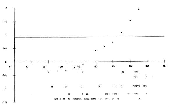
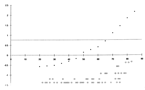
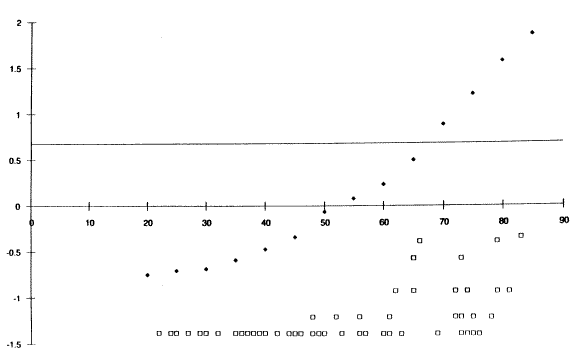
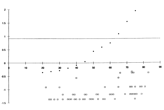
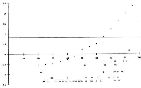
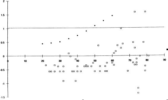
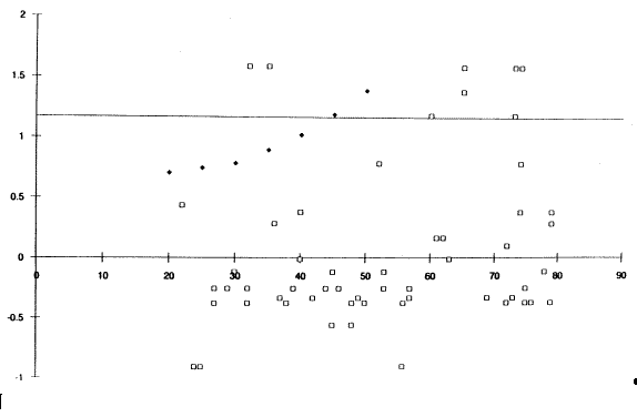
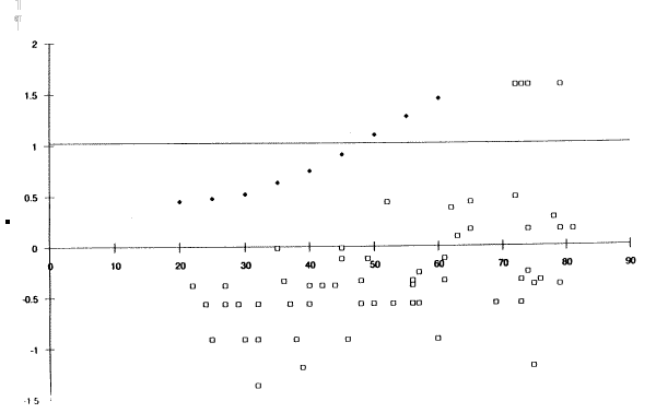
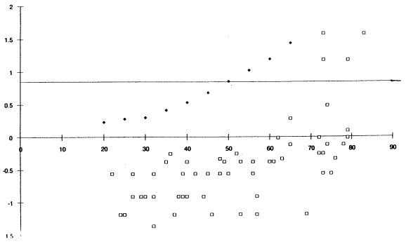
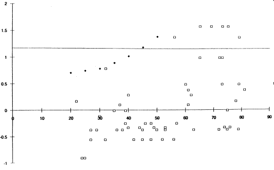
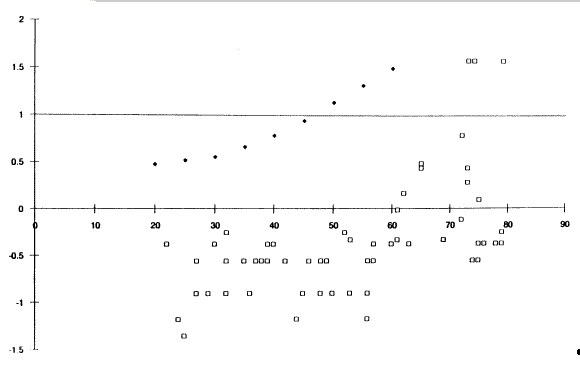
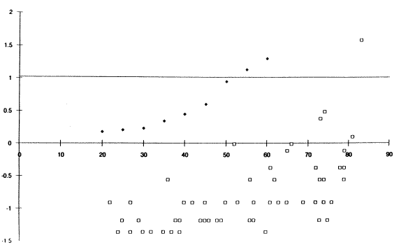
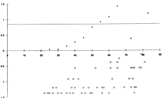
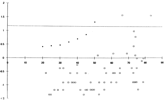
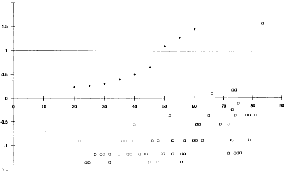
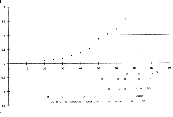
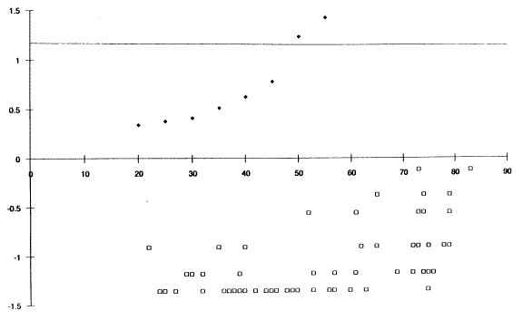
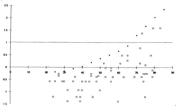
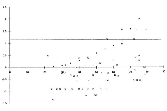
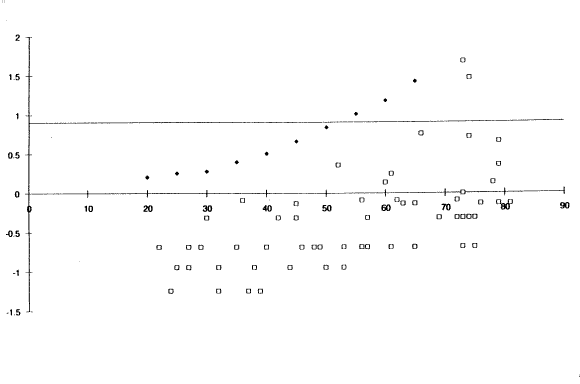
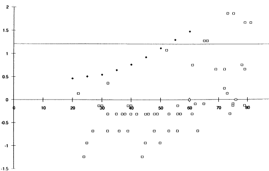
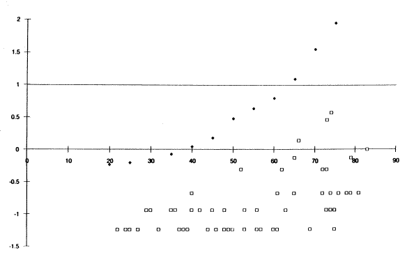
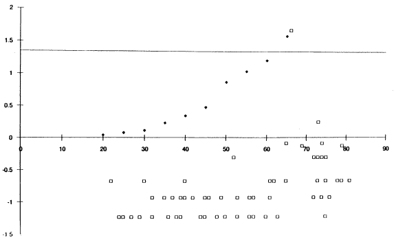
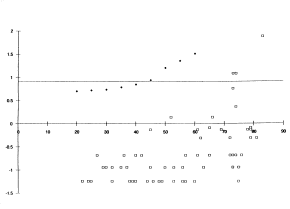
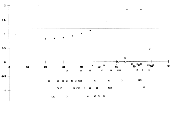
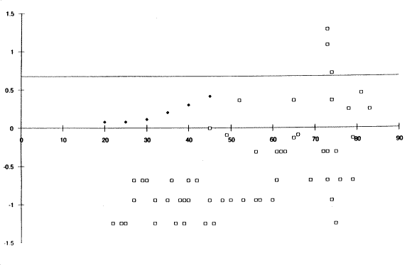
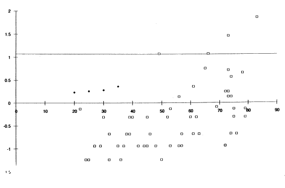
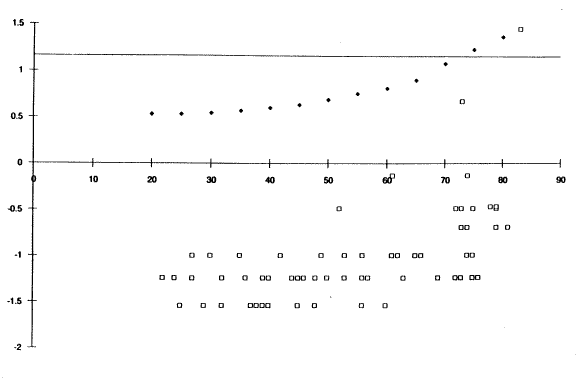
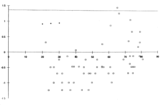
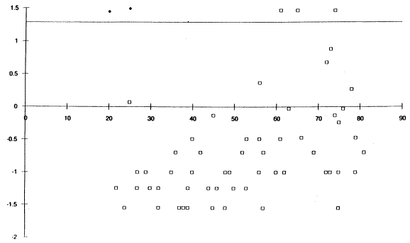
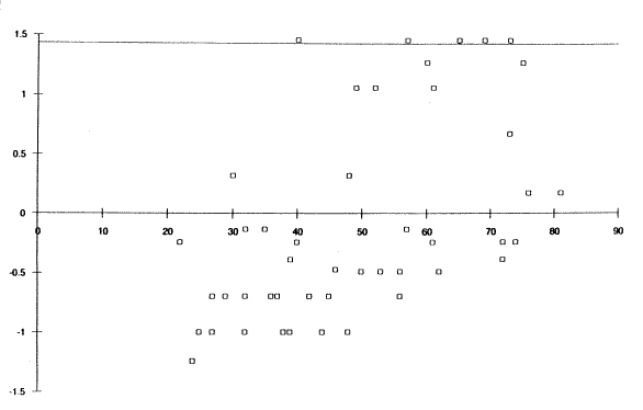
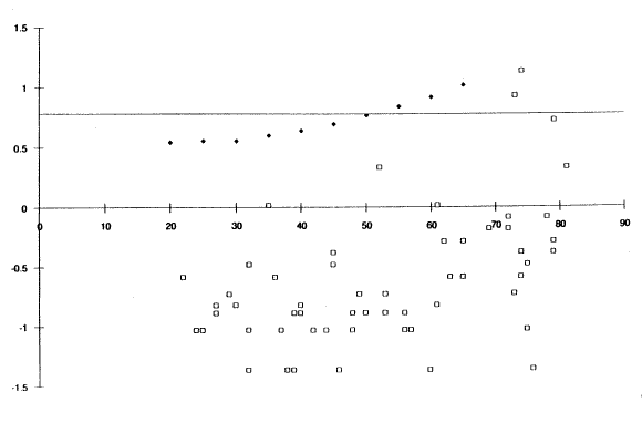
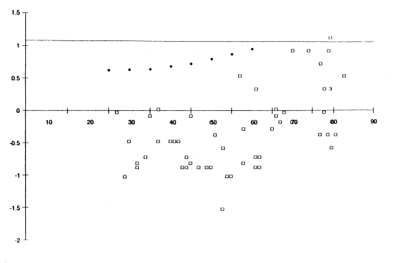
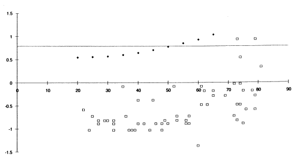
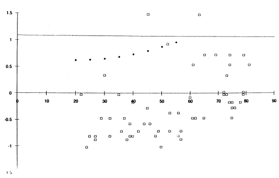
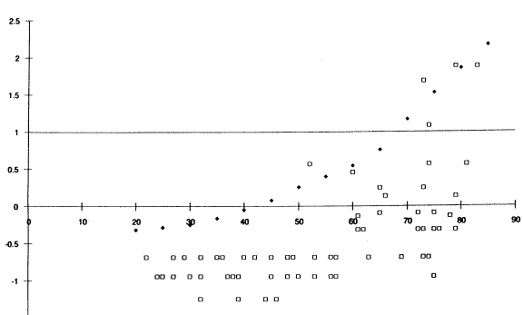
The graphs that follow show the luminance demand data for the signs listed. The graphs can be matched with the data in table 32 using the graph code in the last two columns of the table and in the titles of the graphs. The graphs were scanned out of a draft final report and some information was lost in the conversion. The x-axis shows subject age in years. The y-axis shows the log luminance in cd/m2. The solid data points represent the demand luminance predicted by CARTS. The open points represent the subjects' performance

Figure 9 Right Curve.(E1) Click here for more detail.

Figure 9. Right Curve (E1)

Figure 10 Right Curve (A1). Click here for more detail.

Figure 10. Right Curve (A1)

Figure 11. Right Intersection (E2). Click here for more detail.

Figure 11. Right Intersection (E2)

Figure 12. Right Intersection (F3). Click here for more detail.

Figure 12. Right Intersection (F3)

Figure 13(A2). Click here for more detail.

Figure 13. Right Intersection (A2)

Figure 14 Right Intersection (B3). Click here for more detail.

Figure 14. Right Intersection (B3)

Figure 15 Narrow Bridge. Click here for more detail.

Figure 15. NARROW BRIDGE (E3)

Figure 16. Narrow Bridge. Click here for more detail.

Figure 16. NARROW BRIDGE (A3)

Figure 17. Right Lane Ends. Click here for more detail.

Figure 17. RIGHT LANE ENDS (E4)

Figure 18. Right Lane Ends. Click here for more detail.

Figure 18. RIGHT LANE ENDS (F4)

Figure 19 Right Land Ends (A4) Click here for more detail

Figure 19. RIGHT LANE ENDS (A4)

Figure 20. Right Land Ends (B4) Click here for more detail

Figure 20. RIGHT LANE ENDS (B4)

Figure 21. Bicycle (E5). Click here for more detail

Figure 21. Bicycle (E5)

Figure 22. Cycle (F5). Click here for more detail.

Figure 22. Bicycle (F5)

Figure 23. Bicycle (A5). Click here for more detail.

Figure 23. Bicycle (A5)

Figure 24 Bicyle (B5). Click here for more detail.

Figure 24. Bicycle (B5)

Figure 25. Pedestrian (F1). Click here for more detail.

Figure 25. Pedestrian (F1)

Figure 26. Pedestrian (B1) Click here for more detail.

Figure 26. Pedestrian (B1)

Figure 27. Exit 25 MPH (F2)

Figure 27. EXIT 25 MPH (F2)

Figure 28 Exit 25 MPH (B2)

Figure 28. EXIT 25 MPH (B2)

Figure 29. DO NOT PASS

Figure 29. DO NOT PASS (G2)

Figure 30. DO NOT PASS. Click here for more detail.

Figure 30. DO NOT PASS (C2)

Figure 31. KEEP RIGHT Click here for more detail.

Figure 31. KEEP RIGHT (G3)

Figure 32 KEEP RIGHT. Click here for more detail

Figure 32. KEEP RIGHT (C3)

Figure 33. NO RIGHT TURN. Click here for more detail.

Figure 33. NO RIGHT TURN (G4)

Figure 34. NO RIGHT TURN. Click here for more detail.

Figure 34. NO RIGHT TURN (C4)

Figure 35. ONE WAY - Click here for more detail.

Figure 35. ONE WAY (G5)

Figure 36. ONE WAY - Click here for more detail.

Figure 36. ONE WAY (C5)

Figure 37 STOP (H1) Click here for more detail.

Figurge 37. STOP (H1)

Figure 38 STOP (D1) Click here for more detail.

Figure 38 STOP (D1)

Figure 39 DO NOT ENTER (H3). Click here for more detail.

Figure 39. DO NOT ENTER (H3)

Figure 40 DO NOT ENTER. Click here for more detail.

Figure 40. DO NOT ENTER (D3)

Figure 41. Corning 12 (H2). Click here for more detail.

Figure 41. Corning 12 (H2)

Figure 42. Corning 12 (D2) Click here for more detail.

Figure 42. Corning 12 (D2)

Figure 43 Gravity (H4) Click here for more detail.

Figure 43. Gravity (H4)

Figure 44. Click here for more detail.

Figure 44. Gravity (D4)

Figure 45 Click here for more detail.

Figure 45. SPEED LIMIT 50 (G1)


Table of Contents | Next

Federal Highway Administration | 1200 New Jersey Avenue, SE | Washington, DC 20590 | 202-366-4000
Turner-Fairbank Highway Research Center | 6300 Georgetown Pike | McLean, VA | 22101