U.S. Department of Transportation
Federal Highway Administration
1200 New Jersey Avenue, SE
Washington, DC 20590
202-366-4000
Federal Highway Administration Research and Technology
Coordinating, Developing, and Delivering Highway Transportation Innovations
 |
| This report is an archived publication and may contain dated technical, contact, and link information |
|
Publication Number: FHWA-HRT-07-045
Date: June 2007 |
Applications of ISAT, Interchange Safety Analysis Tool (ISAT): User ManualPDF Version (777 KB)
PDF files can be viewed with the Acrobat® Reader® Applications of ISATISAT was developed for a wide range of applications. This section highlights several interchange analysis applications for which ISAT can be used, including: Application 1—Estimating the safety performance of an existing interchange. Application 2—Predicting the safety performance of design alternatives for a new interchange. Application 3—Predicting the safety performance of design alternatives for an existing interchange. This section also explains how ISAT can be applied to several common interchange types. Types of Analysis applicationsApplication 1—Estimating the Safety Performance of an Existing InterchangeThe first, and most basic, application of ISAT is to estimate the safety performance of an existing interchange. This is done by applying Steps 1 through 8 as described in the Basis Analysis Procedures section of this manual. Estimating the safety performance of an existing interchange can be useful for determining the need and priority for reconstruction of the interchange. In some instances, agencies simply do not have crash data to conduct a safety assessment of an existing interchange. In these instances ISAT provides the means to do so based upon its predictive capabilities. In situations where agencies have crash data available for an existing interchange, the crash data can be combined with the safety experience of similar types of interchanges through state-of-the-art statistical techniques to develop a more accurate safety assessment for the interchange. Application 1 can be useful to highway agencies in their safety management of interchanges. By applying this application to a number of existing interchanges, highway agencies can identify sites with sufficient crashes (actual or estimated) to provide an opportunity for safety improvement. In this way agencies can better determine the priorities for interchange reconstruction projects in their jurisdiction. Application 2—Predicting the Safety Performance of Design Alternatives for a New InterchangePrior to ISAT, no tools were available to design engineers to assess the safety performance of design alternatives for a new interchange. Design alternatives for interchange projects have typically been compared on the basis of cost and traffic operational measures. ISAT fills this void and provides the capability to include safety as one of the primary measures when comparing design alternatives for a new interchange. ISAT was developed to include those geometric, traffic control, and traffic volume components most critical to the overall safety of an interchange, as determined through valid statistical models. By controlling certain components and varying others, engineers can assess the safety consequences of different design alternatives. With ISAT, design engineers now have the capability to assess the safety performance of different design alternatives which can be useful in selecting the final design for a new interchange. Application 3—Predicting the Safety Performance of Design Alternatives for an Existing InterchangeThis application is very similar to Application 2, except that this application focuses on design alternatives for an existing interchange rather than a new interchange. ISAT provides the capability to include safety as one of the primary measures when comparing design alternatives for an existing interchange. ISAT was developed to include those geometric, traffic control, and traffic volume components most critical to the overall safety of an interchange. By controlling certain components, and varying others, engineers can assess the safety consequences of different design alternatives. With this being an application for an existing interchange, ISAT also provides the capability to compare the predicted safety performance of proposed design alternatives to the safety performance of the existing interchange design (i.e., the no-build scenario). APPLICATION OF ISAT TO SPECIFIC INTERCHANGE CONFIGURATIONSThis section explains how ISAT can be applied to four common interchange types: full diamond, partial cloverleaf, full cloverleaf, and directional. Figures 5 through 8 illustrate these interchange types. These examples provide sufficient information to guide the user in applying the tool to other, less standard, interchange configurations. In applying ISAT to any interchange, study area boundaries must be established at each mainline freeway leg and each arterial crossroad leg. These study area boundaries should be far enough from the ramps that the entire interchange influence area on the mainline freeway is included within the study area boundaries. If the safety performance of an existing and proposed interchange design is being compared, or if several proposed design alternatives for the interchange are being compared, the same study area boundaries must be used for all design alternatives, and the study area must be large enough to include all of the alternatives.
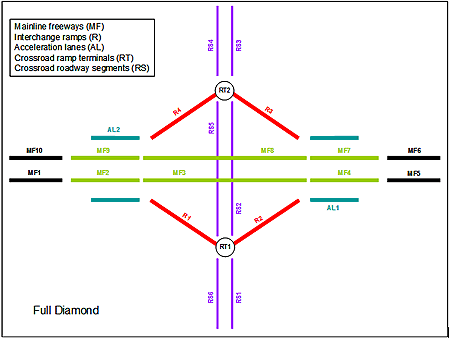
Figure 5. Sample application of ISAT to a full diamond interchange.
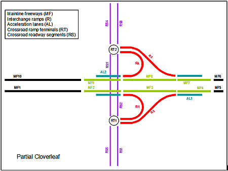
Figure 6. Sample application of ISAT to a partial cloverleaf interchange.
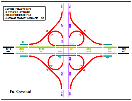
Figure 7. Sample application of ISAT to a full cloverleaf interchange.
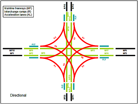
Figure 8. Sample application of ISAT to a directional interchange. Full Diamond InterchangeThe full diamond interchange in figure 5 would be subdivided for analysis purposes as follows:
Partial Cloverleaf InterchangeThe partial cloverleaf interchange in figure 6 would be subdivided for analysis purposes as follows:
Full Cloverleaf InterchangeFull cloverleaf interchanges can, at present, be represented only imperfectly in ISAT. Research to develop additional safety prediction models so that ISAT can address full cloverleaf interchanges completely is needed. The full cloverleaf interchange in figure 7 would be subdivided for analysis purposes as follows:
A full cloverleaf interchange has no crossroad ramp terminals. It should also be noted that ISAT, at present, has no capability to estimate the safety performance of any collector-distributor roads that may be present in cloverleaf interchanges. Directional InterchangeThe directional freeway-to-freeway interchange in figure 8 would be subdivided for analysis purposes as follows:
A directional freeway-to-freeway interchange has no crossroad ramp terminals or crossroad segments. Extended Roadway Networks Near InterchangesSome users may wish to apply ISAT to estimate the safety performance for extended roadway networks near interchanges. For example, ISAT can be applied to evaluate two or more interchanges in sequence along a freeway or arterial roadway networks that connect interchanges to one another or to nearby development. To evaluate two or more interchanges in sequence along a freeway, all of the mainline freeway segments, ramps, crossroad ramp terminals and intersections, and crossroad segments for the interchanges should be included in the ISAT input data. In addition, the entire mainline freeway between the interchanges should be included in one or more mainline freeway segments in the ISAT input data. The arterial roadway network surrounding a freeway that connects the interchanges to one another or to nearby development can be evaluated with ISAT. Additional arterial crossroad roadway segments and intersections on the network of interest can be included in the ISAT input data, together with the data for the interchanges themselves. Data for all intersections on arterial roadways in the network should be included in the ISAT input data for crossroad ramp terminals, and data for arterial roadway segments in the network should be included in the ISAT input data for crossroad segments. The number of interchanges and the extent of the network considered is constrained only by the limit of 50 mainline freeway segments, 50 ramps, 50 crossroad ramp terminals and intersections, and 50 crossroad segments in the ISAT software. |