Applications of ISAT, Interchange Safety Analysis Tool (ISAT): User Manual
PDF files can be viewed with the Acrobat® Reader®
Input Requirements
This section summarizes the input requirements for ISAT. The user enters geometric design, traffic control, and traffic volume data for each interchange element; these data are input into individual cells within the Excel workbook. For programming purposes input data are broken down into two categories: numeric and character. When inputting numeric values, the required units for the data are displayed for the user; it is expected that reasonable values will be entered. Unreasonable values may produce skewed results. Character input is more closely controlled than numeric. An arranged list of acceptable character input is provided to the user for each variable. This is done so that the software is capable of recognizing the text when performing calculations. A structured character input is essential to proper program function. Either inputting characters where numeric values are expected, or entering characters other than those prescribed by ISAT, will result in various error messages and program failure.
The user inputs data into five primary worksheets within ISAT. The worksheets are divided based on the individual interchange elements and the interchange area (i.e., analysis area) as a whole:
- General interchange inputs.
- Mainline freeway segments.
- Ramps.
- Crossroad ramp terminals and intersections.
- Crossroad segments.
The following sections present the variables required for the general interchange area as a whole and the individual interchange elements, their definitions, and appropriate inputs. Each input worksheet is designed in a similar format. The user inputs data much like adding information within a table. Variables are designated either as mandatory or optional. Mandatory variables must be filled-in by the user for processing to be performed. Optional variables provide additional or supplemental information to be used in the computations when data are available, but the computations can run to completion when optional inputs are not provided.
General Interchange Inputs
The variables covered in this section represent data that are universal over all of the interchange elements. The input values are used in data processing algorithms for the entire interchange (or system of interchanges) and for individual components. Figure 2 illustrates the Input-General worksheet. The variables included on this worksheet are further defined in table 1. Table 1 presents the variable name, variable number, the expected input format, applicable definition, and whether the variable is mandatory or optional.
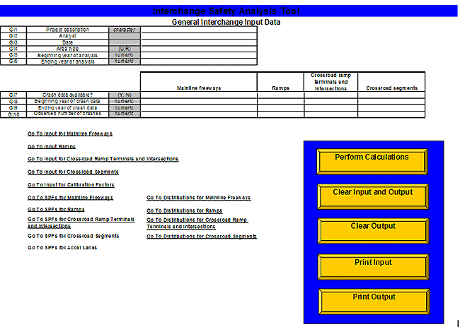
Figure 2. General Interchange Input Data screen.
Table 1. Summary of input variables for general interchange area.
Variable Name |
Variable No. |
Format |
Definition |
Type |
| Project description |
GI1 |
Character |
Short description that describes the project. |
Optional |
| Analyst |
GI2 |
Numeric |
User name. |
Optional |
| Date |
GI3 |
Character |
Date of analysis. |
Optional |
| Area type |
GI4 |
Character(U, R) |
General character of land use surrounding the interchange, preferably based on FHWA urban area boundaries:U = UrbanR = Rural |
Mandatory |
| Begin year of analysis |
GI5 |
Numeric(calendar year) |
Value sets the first year of the period for which output reports will be created. |
Mandatory |
| End year of analysis |
GI6 |
Numeric(calendar year) |
Value sets the final year of the period for which output reports will be created. |
Mandatory |
| Crash data available |
GI7 |
Character(Y, N) |
Field indicates whether crash data are available for input on mainline freeway segments, ramps, ramp terminals and intersections, or crossroad roadway segments, respectively. |
Mandatory |
| Begin year of crash data |
GI8 |
Numeric(calendar year) |
Field indicates the first year for which crash data are available for input for the respective interchange elements. |
Mandatory, if GI 7 equals Y |
| End year of crash data |
GI9 |
Numeric(calendar year) |
Field indicates the final year for which crash data are available for input for the respective interchange elements. |
Mandatory, if GI 7 equals Y |
| Observed number of crashes |
GI10 |
Numeric |
Field indicates the total number of observed crashes during the specified period (i.e., GI8 through GI9) across all individual mainline freeway segments, ramps, ramp terminals and intersections, and/or crossroad roadway segment included in the analysis. |
Mandatory, if GI 7 equals Y |
On this input worksheet, the user provides general information that is used in a number of ways. The first three variables (i.e., project description [GI1], analyst [GI2], and date [GI3]) are primarily for recording purposes, so when the user reviews an analysis he or she has a sense of why the analysis was performed, or the project to which the analysis applies, who conducted the analysis, and the date the analysis was conducted. Classifying the area type [GI4] around the interchange area is important because ISAT makes use of SPFs. Different SPFs are available for both urban and rural areas. Specifying the area type enables the tool to implement the correct SPFs for use in the processing algorithms. The user also must specify the dates for the analysis (i.e., beginning year of the analysis [GI5] and ending year of the analysis [GI6]). ISAT is designed to perform calculations only for full calendar years. Analyses over partial years or months cannot be performed, and the analysis period is limited to a maximum of 20 years.
The other types of information that the user can provide on the Input-General worksheet concern crash data. ISAT can perform calculations with or without crash data provided by the user. When no crash data are available for the analysis area (i.e., mainline freeway segments, ramps, crossroad ramp terminals and intersections, or crossroad segments), calculations are still performed using the SPFs, and the crash frequencies represent predicted values using the SPFs. When crash data are available, the crash data are combined with the predicted values from the SPFs using an Empirical Bayes methodology, so the final crash frequencies reflect combined estimates using the crash data and the predicted values (i.e., from the SPFs).
When inputting crash data, there are several points that should be kept in mind:
- The crash data are grouped according to the four major elements of the interchange area: mainline freeways, ramps, ramp terminals and intersections, and crossroad segments. Within each element, if the user indicates that crash data are available by entering "Y" into the GI7 row, the program will function properly only if numerical values are entered for the years of crash data and observed number of crashes. If the user indicates that crash data are not available by entering a "N" into the GI7 row, then no further information is necessary in the crash data input area. Any information that is entered will be ignored. Crash data can be included for any, or all, of the interchange elements without affecting the elements with no crash data available.
- The maximum allowable crash data period is 10 years; ISAT is designed to perform calculations only for full calendar years. The crash data period is completely independent of the user inputted years of analysis and can have occurred before, concurrent to, or after the analysis period.
- The observed number of crashes input by the user should reflect the crash count aggregated over all of the individual components of each interchange element. For example in figure 1, crash counts for MF1 through MF10 should be summed and included together. If crash data are available for only a portion of the individual components of a primary element within the analysis area, these data should not be considered in the analysis. For example (again referring to figure 1), if crash data are available for the eastbound mainline freeway segments (i.e., MF1 through MF5) but no crash data are available for the westbound lanes (i.e., MF6 through MF10), inputting the aggregated crash data for only 5 of the 10 mainline freeway segments included in the analysis area would lead to erroneous results. The program automatically considers the crash data to be aggregated over all of the individual components of a primary element within the analysis area. Care should be taken to input only crash data for the areas included in the analysis in order to receive accurate results.
When entering crash data, the following rules should be applied:
- Crashes that occur along or within mainline freeway segments, deceleration lanes, and acceleration lanes should be attributed to mainline freeway segments. Deceleration lanes are defined to begin at the taper and terminate at the painted nose of the gore area of the off-ramp (figure 3). Acceleration lanes are defined to begin at the painted nose of the gore area of the on-ramp and terminate at the end of the taper.
- All crashes that occur within 76.2 meters (m) (250 feet (ft)) of a crossroad ramp terminal or intersection and are classified as intersection-related should be attributed to crossroad ramp terminals and intersections. All crashes that occur within 76.2 m (250 ft) of a crossroad ramp terminal or intersection but are not classified as intersection-related should be attributed either to ramps or crossroad roadway segments.
- All crashes that occur along the ramp proper portion of an interchange ramp should be attributed to ramps. For off-ramps, the ramp proper is defined to begin at the painted nose of the gore area and terminate at the crossroad ramp terminal. For crashes that occur on the ramp proper and are within 76.2 m (250 ft) of the crossroad ramp terminal, if the crash is related to the operation of the ramp terminal (i.e., intersection-related), then the crash should be attributed to the crossroad ramp terminal, but if the crash is not related to the operation of the ramp terminal, then the crash should be attributed to the ramp. For on-ramps, the ramp proper begins at the crossroad ramp terminal and terminates at the painted nose of the gore area.
- Crashes that occur along or within arterial crossroad roadway segments should be attributed as such. The exceptions are those crashes that occur within 76.2 m (250 ft) of a ramp terminal or intersection and are intersection-related, in which case the crashes should be attributed to crossroad ramp terminals and intersections.
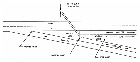
Figure 3. Typical gore area characteristics2.
Table 2 presents the Input-General worksheet completed with sample data for a rural diamond interchange. This example will be carried throughout the remainder of this user manual. The example is based on the analysis area shown in figure 1. In this example a safety assessment is being made of an interchange for a 10-year period in the future. Five years of crash data are available for each type of interchange element and will be incorporated into the calculations.
Table 2. Example data for rural diamond interchange (Input-General).
GI1 |
Project Description |
Character |
Diamond Interchange Example 1 |
|
|
|
GI2 |
Analyst |
|
MRI |
|
|
|
GI3 |
Date |
|
10/27/2006 |
|
|
|
GI4 |
Area type |
(U,R) |
R |
|
|
|
GI5 |
Beginning year of analysis |
numeric |
2008 |
|
|
|
GI6 |
Ending year of analysis |
numeric |
2017 |
|
|
|
| |
|
|
|
|
|
|
| |
|
|
|
|
|
|
| |
|
|
Mainline Freeways |
Ramps |
Crossroad Ramp Terminals and Intersections |
Crossroad Segments |
GI7 |
Crash data available? |
(Y, N) |
Y |
Y |
Y |
Y |
GI8 |
Beginning year of crash data |
numeric |
2001 |
2001 |
2001 |
2001 |
GI9 |
Ending year of crash data |
numeric |
2005 |
2005 |
2005 |
2005 |
GI10 |
Observed number of crashes |
numeric |
65 |
8 |
18 |
34 |
Mainline Freeway Segment Inputs
The variables covered in this section represent data unique to the mainline freeway segment portion of the interchange area. The input values are used in the data processing algorithms to predict crashes along freeway mainline segments. Table 3 illustrates the Input Mainline Freeways worksheet. Table 4 provides greater detail associated with each of the mainline freeway variables.
The following information provides guidance on defining mainline freeway segments. Mainline freeway segments are considered independently in each direction of travel, either northbound, southbound, eastbound, or westbound (NB, SB, EB, or WB). Mainline freeway segments always break where traffic volumes change (i.e., near ramp gore points or at interchange influence areas). Mainline freeway segments are divided into two general classes: mainline freeway segments within an interchange area and mainline freeway segments outside an interchange area. The SPFs for mainline freeway segments within interchange areas attempt to account for the increased level of weaving, lane changing, and acceleration/deceleration that takes place immediately upstream, downstream, and between interchange ramps. The SPFs for mainline freeway segments outside an interchange area model the safety experience of basic mainline freeway segments having homogenous characteristics. In general terms, the limits of mainline freeway segments within interchange areas are defined to extend approximately 0.48 kilometer (km) (0.3 mile (mi)) upstream from the gore (i.e., painted nose of the gore area) of the first ramp of a particular interchange to approximately 0.43 km (0.3 mi) downstream from the gore (i.e., painted nose of the gore area) of the last ramp of the given interchange. Conversely, all mainline freeway segments that extend beyond these defined limits for within interchange areas are by definition mainline freeway segments outside an interchange area.
On the input worksheet for mainline freeway segments, the user provides general information for each individual mainline freeway segment to be considered in a given analysis. The first variable (i.e., segment number [MF1]) is for bookkeeping purposes. This segment number is carried through and provided on output reports if there is a particular need to investigate the expected safety experience of an individual segment. This segment number is also used so that the necessary calculations are made for appropriate segments adjacent to on-ramps. The next few variables (i.e., segment description [MF2], direction of travel [MF3], beginning MP [MF4], and ending MP [MF5]) are primarily for recording purposes so when the user reviews an analysis, the user has a sense of where the individual segment is located within the analysis area. Segment length [MF6] is one of two key predictor variables in the SPFs for mainline freeway segments; the other key predictor variable is mainline ADT. (Note: Throughout the manual, all traffic volumes are referring to annual average daily traffic volumes. For simplicity purposes, annual average daily traffic is being abbreviated ADT.) Mainline ADT [MF8], mainline ADT year [MF9], and ADT growth rate [MF10] are used to determine the appropriate mainline ADT for each given year in the analysis period. The number of through lanes [MF7] and within interchange area [MF11] are used to select the correct SPF for incorporation in the processing algorithms for the given segment. SPFs for 4-lane (2 lanes per direction), 6-lane (3-lanes per direction), and 8+ lane (4 or more lanes per direction) freeways are incorporated in ISAT. For rural areas valid inputs for number of through lanes are 2 and 3. For urban areas valid inputs
Table 3. Mainline freeway segments input data screen.
| MF1 |
MF2 |
MF3 |
MF4 |
MF5 |
MF6 |
MF7 |
MF8 |
MF9 |
MF10 |
MF11 |
| Segment Number |
Segment Description |
Direction of Travel |
Beginning MP |
Ending MP |
Length of Segment |
Number of Through lanes (Directional) |
Mainline ADT (Directional) |
Mainline ADT Year |
ADT Growth Rate |
Within Interchange Area? |
| numeric |
character |
(NB, SB, EB, WB) |
numeric |
numeric |
km (mi) |
(2, 3, 4) |
(veh/day) |
numeric |
(percent/ year) |
(Y, N) |
| 1 |
|
|
|
|
|
|
|
|
|
|
| 2 |
|
|
|
|
|
|
|
|
|
|
| 3 |
|
|
|
|
|
|
|
|
|
|
| 4 |
|
|
|
|
|
|
|
|
|
|
| 5 |
|
|
|
|
|
|
|
|
|
|
| 6 |
|
|
|
|
|
|
|
|
|
|
| 7 |
|
|
|
|
|
|
|
|
|
|
Table 4. Summary of input variables for mainline freeway segments.
Variable Name |
Variable No. |
Format |
Definition |
Type |
| Segment number |
MF1 |
Numeric |
Each mainline freeway segment included in the analysis must be identified by a sequential integer, starting with 1; this variable is not used in calculations but is carried through onto the output report. |
Mandatory |
| Segment description |
MF2 |
Character |
This field is available to describe each mainline freeway segment; a typical description might be "NB mainline lanes upstream of off-ramp" or "SB mainline lanes between ramps"; this variable is not used in calculations but is carried through onto the output report. |
Optional |
| Direction of travel |
MF3 |
Character(NB, SB, EB, WB) |
This variable corresponds to the general direction of travel for the individual segment; this variable is not used in calculations but is carried through onto the output reports. |
Optional |
| Begin MP |
MF4 |
Numeric |
This is the beginning milepost or other applicable coordinate for the segment; this variable is not used in calculations but is carried through onto the output reports. |
Optional |
| End MP |
MF5 |
Numeric |
This is the ending milepost or other applicable coordinate for the segment; this variable is not used in calculations but is carried through onto the output reports. |
Optional |
| Length of segment |
MF6 |
Numeric(mi) |
This is the length of the mainline segment, specified in miles, generally to the nearest hundredth of a mile. |
Mandatory |
| Number of through lanes |
MF7 |
Numeric |
This variable includes all lanes on the segment in a given direction [MF3] that are used by through traffic. This does not include auxiliary lanes. |
Mandatory |
| Mainline ADT |
MF8 |
Numeric
(veh/day) |
This is the best available estimate of the annual average daily traffic volume for the mainline freeway segment in the given direction of travel [MF3]. |
Mandatory |
| Mainline ADT Year |
MF9 |
Numeric
(calendar year) |
This field indicates the year to which the mainline ADT [MF8] applies. |
Mandatory |
| Traffic volume growth rate |
MF10 |
Numeric (percent/year) |
This value corresponds to the average growth rate of traffic for the given freeway mainline segment for the analysis period. |
Mandatory |
| Within interchange area |
MF11 |
Character(Y, N) |
This field identifies whether the segment is located within an interchange area or outside.Y = segment is located within an interchange areaN = segment is not located within an interchange area |
Mandatory |
for number of through lanes are 2, 3, and 4. The Safety Performance Functions (Mainline Freeway Segment SPFs) section provides more detail on the mainline freeway segment SPFs incorporated in ISAT.
Finally, the maximum number of mainline freeway segments that may be considered in an analysis is 50. ISAT will not consider segments numbered greater than 50, even if the user inputs the same data in the given columns.
Table 5 presents the Input Mainline Freeway worksheet, completed with sample data, for the rural diamond interchange example. Ten individual mainline freeway segments are included in this example. Six of the segments are defined to be within the interchange area, and four segments are defined to be outside of the interchange area.
Ramp Inputs
The variables covered in this section represent data unique to the ramp portion of the interchange area. The input values are used in the data processing algorithms to predict crashes along the ramp proper section of ramps (i.e., both on- and off-ramps) and along acceleration lanes of on-ramps. Table 6 illustrates the Input Ramps worksheet. Table 7 provides greater detail associated with each of the ramp variables.
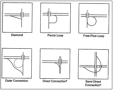
On the input worksheet for ramps, the user provides general information for each individual ramp to be considered in a given analysis. The first variable (i.e., ramp number [R1]) is for bookkeeping purposes. This number is carried through and provided on output reports if there is a particular need to investigate the expected safety experience of an individual ramp. Ramp description (R2) and direction of travel (R3) are primarily for recording purposes so when the user reviews an analysis, the user has a sense of where the ramp is located within the analysis area. Since the direction of travel on ramps is seldom a straight line or in a cardinal direction, it is recommended that the user develop a convention for assigning direction of travel to ramps (e.g., ramps are assigned the direction of travel of the associated adjacent mainline freeway segment). Ramp type (R4) and ramp configuration (R5) are used to select the correct SPF for incorporation in the processing algorithms for the given ramp. Figure 4 provides an illustration of typical ramp configurations. If a user wants to include another type of ramp in the analysis other than a diamond (D), parclo loop (PL), free-flow loop (FFL), or directional (DIR) ramp, the user should enter the ramp configuration (i.e., D, PL, FFL, or DIR) that most closely resembles the ramp of interest, recognizing that the prediction for the given ramp would be based on a SPF that was not developed for that particular ramp configuration. Ramp length (R6) is one of two key predictor variables for estimating the crash frequency on the ramp proper; the other key predictor variable is ramp ADT. Ramp ADT (R7), ramp ADT year (R8), and ramp ADT growth rate (R9) are used to determine the appropriate ramp ADT for each given year in the analysis period. Segment number for adjacent mainline freeway segment (R10) indicates the segment number (MF1) associated with the freeway segment adjacent to the speed-change lane of the given ramp. This information is most critical in the case of on-ramps with acceleration lanes because the SPFs for mainline freeway segments within interchange areas include crashes that occur on speed-change lanes (i.e., acceleration lanes), and because SPFs are available to predict
Table 5. Example data for rural diamond interchange (Input Mainline Freeways).
| MF1 |
MF2 |
MF3 |
MF4 |
MF5 |
MF6 |
MF7 |
MF8 |
MF9 |
MF10 |
MF11 |
| Segment Number |
Segment Description |
Direction of Travel |
Beginning MP |
Ending MP |
LengthofSegment |
Number of Through lanes (Directional) |
Mainline ADT (Directional) |
Mainline ADT Year |
ADT Growth Rate |
Within Interchange Area? |
| numeric |
character |
(NB, SB,EB, WB) |
numeric |
numeric |
km (mi) |
(2, 3, 4) |
(veh/day) |
numeric |
(percent/ year) |
(Y, N) |
| 1 |
EB Upstream Segment (MF1) |
EB |
0.000 |
1.000 |
1.61(1.000) |
2 |
4,000 |
2004 |
2.0 |
N |
| 2 |
EB Segment Adjacent to Decel Lane (MF2) |
EB |
1.000 |
1.300 |
0.48(0.300) |
2 |
4,000 |
2004 |
2.0 |
Y |
| 3 |
EB Between Ramps(MF3) |
EB |
1.300 |
1.850 |
0.89(0.550) |
2 |
3,500 |
2004 |
2.0 |
Y |
| 4 |
EB Segment Adjacent to Accel Lane (MF4) |
EB |
1.850 |
2.150 |
0.48(0.300) |
2 |
4,500 |
2004 |
2.0 |
Y |
| 5 |
EB Downstream Segment (MF5) |
EB |
2.150 |
3.150 |
1.61(1.000) |
2 |
4,500 |
2004 |
2.0 |
N |
| 6 |
WB Upstream Segment (MF6) |
WB |
3.150 |
2.150 |
1.61(1.000) |
2 |
4,500 |
2004 |
2.0 |
N |
| 7 |
WB Segment Adjacent to Decel Lane (MF7) |
WB |
2.150 |
1.850 |
0.48(0.300) |
2 |
4,500 |
2004 |
2.0 |
Y |
| 8 |
WB Between Ramps(MF8) |
WB |
1.850 |
1.300 |
0.89(0.550) |
2 |
3,500 |
2004 |
2.0 |
Y |
| 9 |
WB Segment Adjacent to Accel Lane (MF9) |
WB |
1.300 |
1.000 |
0.48(0.300) |
2 |
4,000 |
2004 |
2.0 |
Y |
| 10 |
WB Downstream Segment (MF10) |
WB |
1.000 |
0.000 |
1.61(1.000) |
2 |
4,000 |
2004 |
2.0 |
N |
| 11 |
|
|
|
|
|
|
|
|
|
|
Table 6. Ramps input data screen.
| R1 |
R2 |
R3 |
R4 |
R5 |
R6 |
R7 |
R8 |
R9 |
R10 |
R11 |
R12 |
| Ramp Number |
Ramp Description |
Direction of Travel |
Ramp Type |
Ramp Configuration |
Ramp Length |
Ramp ADT |
Ramp ADT Year |
Ramp ADT Growth Rate |
Segment Number for Adjacent Mainline Freeway Segment |
Acceleration Lane |
Acceleration Lane Length |
| numeric |
character |
(NB, SB, EB, WB) |
(ON, OFF, FWY) |
(D, PL, FFL, DIR) |
km (mi) |
(veh/day) |
numeric |
(percent/year) |
numeric |
(Y, N) |
km (mi) |
| 1 |
|
|
|
|
|
|
|
|
|
|
|
| 2 |
|
|
|
|
|
|
|
|
|
|
|
| 3 |
|
|
|
|
|
|
|
|
|
|
|
| 4 |
|
|
|
|
|
|
|
|
|
|
|
| 5 |
|
|
|
|
|
|
|
|
|
|
|
| 6 |
|
|
|
|
|
|
|
|
|
|
|
| 7 |
|
|
|
|
|
|
|
|
|
|
|
Table 7. Summary of input variables for ramps.
| Variable Name |
Variable No. |
Format |
Definition |
Type |
| Ramp number |
R1 |
Numeric |
Each ramp included in the analysis must be identified by a sequential integer, starting with 1; this variable is not used in calculations but is carried through onto the output report. |
Mandatory |
| Ramp description |
R2 |
Character |
This field is available to describe each ramp; a typical description might be "NB diamond off-ramp" or "SB parclo on-ramp""; this variable is not used in calculations but is carried through onto the output report. |
Optional |
| Direction of travel |
R3 |
Character (NB, SB, EB, WB) |
This variable corresponds to the direction of travel of the ramp; this variable is not used in calculations but is carried through onto the output report. |
Optional |
| Type of ramp |
R4 |
Character(ON, OFF, FWY) |
On-ramps service vehicles entering the mainline; off-ramps service vehicles leaving the mainline; freeway-to-freeway ramps service vehicles leaving one mainline freeway and entering another; the type of ramps are distinguished by the following codes:
ON = on-ramp
OFF = off-ramp
FWY = freeway-to-freeway ramp |
Mandatory |
| Ramp configuration |
R5 |
Character(D, PL, FFL, DIR) |
This variable defines the basic configuration of the ramp; the abbreviated codes correspond as follows:
D = diamond rampPL = parclo loop ramp
FFL = free-flow loop ramp
DIR = directional ramp |
Mandatory |
| Ramp length |
R6 |
Numeric(mi) |
This length is measured from the gore point at the freeway ramp terminal to the crossroad ramp terminal (typically measured to the nearest hundredth of a mile). |
Mandatory |
| Ramp ADT |
R7 |
Numeric(veh/day) |
This is the best available estimate of the annual average daily traffic volume for the ramp proper. |
Mandatory |
| Ramp ADT year |
R8 |
Numeric |
Field indicates the year to which the ramp ADT [R7] applies. |
Mandatory |
| Ramp ADT growth rate |
R9 |
Numeric(percent/ year) |
Value corresponds to the average growth rate of traffic for the given ramp for the analysis period. |
Mandatory |
| Segment number for adjacent mainline freeway |
R10 |
Numeric |
The segment number (i.e., MF1) associated with the freeway segment adjacent to the speed-change lane of the given ramp. |
Mandatory |
| Acceleration lane? |
R11 |
Character(Y, N) |
A code identifying whether there is an acceleration lane associated with the given ramp:
Y = yes, there is an acceleration lane attached to the ramp
N = no, there is no acceleration lane attached to the ramp |
Mandatory |
| Length of acceleration lane |
R12 |
Numeric(km (mi)) |
This distance is measured for the acceleration lane from the gore point of the ramp to the end of the taper for an acceleration lane; distances should be rounded to the nearest hundredth of a mile; if no acceleration lane is present, "0.00" should be entered in this field, and R11 should be set equal to "N." |
Mandatory; when R11 equals Y. |
crashes along acceleration lanes. By providing the segment number for the adjacent mainline freeway segment, crash estimates for the respective mainline freeway segment can be adjusted to account for the actual length of the adjacent acceleration lane by making certain methodological assumptions. Indicating whether the ramp has an associated acceleration lane (R11) determines whether these assumptions are applied during the processing procedures. Acceleration lane length (R12) is one of the key predictor variables of the SPF for estimating the crash frequency along an acceleration lane.
a When used in directional interchanges.
Figure 4. Typical ramp configurations3.
Finally, the maximum number of ramps that may be considered in an analysis is 50. ISAT will not consider ramps numbered greater than 50, even if the user inputs the same data in the given columns.
Table 8 presents the Input Ramp worksheet completed with sample data for the rural diamond interchange example. Four individual ramps are included in this example.
Crossroad Ramp Terminals and Intersections Inputs
The variables covered in this section represent input data unique to crossroad ramp terminals and intersections near the interchange area. The area associated with the crossroad ramp terminal or intersection is defined as the area within 7.62 m (250 ft) of the intersection on each approach leg. The input values are used in the data processing algorithms for predicting crashes associated with the crossroad ramp terminal or intersection. Table 9 illustrates the Input Ramp Terminals worksheet; the included variables are listed below in table 10 along with the expected input format in parentheses accompanied by applicable definitions.
On the input worksheet for crossroad ramp terminals and intersections, the user provides general information for each individual crossroad ramp terminal and intersection to be considered in a given analysis. The first variable (i.e., terminal number [RT1]) is for bookkeeping purposes. This number is carried through and provided on output reports if there is a particular need to investigate the expected safety experience of an individual ramp terminal or intersection. Terminal description [RT2] is primarily for recording purposes so when the user reviews an analysis, the user has a sense of where the ramp terminal or intersection is located within the analysis area. Type of traffic control [RT3] and number of legs [RT4] are used to select the correct SPF for incorporation in the processing algorithms for the given ramp terminal or intersection. SPFs for 3- and 4-leg STOP-controlled and signalized intersections are incorporated in ISAT. The Safety Performance Functions (Crossroad Ramp Terminals and Intersections SPFs) section provides more detail on the crossroad ramp terminal and intersection SPFs incorporated in ISAT. Major-road or crossroad segment ADT [RT5], major-road or crossroad segment ADT year [RT6], major-road or crossroad segment growth rate [RT7], minor-road or ramp ADT [RT8], minor-road or ramp ADT year [RT9], and minor-road ramp growth rate [RT10] are used to determine the appropriate major-road and minor-road ADT for each given year in the analysis period. Terminal type [RT11] is used to distinguish whether the terminal operates as a ramp terminal or a conventional intersection. The primary difference in the calculations between classifying a terminal as either a ramp terminal or intersection is as follows:
- When the terminal type is entered as RT (i.e., ramp terminal), the value for the minor-road ADT entered into the SPF calculations is the actual value input by the user [RT8] taking into consideration the yearly growth factor, etc.
- When the terminal type is entered as CI (i.e., conventional intersection), the value for the minor-road ADT entered into the SPF calculations is 2 times the actual value input by the user [RT8] taking into consideration the yearly growth factor, etc. (i.e., 2 x ADT).
Table 8. Example data for rural diamond interchange (Input Ramps).
| R1 |
R2 |
R3 |
R4 |
R5 |
R6 |
R7 |
R8 |
R9 |
R10 |
R11 |
R12 |
| Ramp Number |
RampDescription |
Direction of Travel |
Ramp Type |
Ramp Configuration |
Ramp Length |
Ramp ADT |
Ramp ADT Year |
Ramp ADT Growth Rate |
Segment Number for Adjacent Mainline Freeway Segment |
Acceleration Lane |
Acceleration Lane Length |
| numeric |
character |
(NB, SB,EB, WB) |
(ON, OFF, FWY) |
(D, PL, FFL, DIR) |
km (mi) |
(veh/day) |
numeric |
(percent/year) |
numeric |
(Y, N) |
km (mi) |
| 1 |
EB Off-Ramp (R1) |
EB |
OFF |
D |
0.48(0.300) |
500 |
2004 |
2.0 |
2 |
N |
|
| 2 |
EB On-Ramp (R2) |
EB |
ON |
D |
0.56(0.350) |
1,000 |
2004 |
2.0 |
4 |
Y |
0.32(0.200) |
| 3 |
WB Off-Ramp (R3) |
WB |
OFF |
D |
0.48(0.300) |
1,000 |
2004 |
2.0 |
7 |
N |
|
| 4 |
WB On-Ramp (R4) |
WB |
ON |
D |
0.56(0.350) |
500 |
2004 |
2.0 |
9 |
Y |
0.32(0.200) |
| 5 |
|
|
|
|
|
|
|
|
|
|
|
Table 9. Crossroad ramp terminal and intersection input data screen.
| RT1 |
RT2 |
RT3 |
RT4 |
RT5 |
RT6 |
RT7 |
RT8 |
RT9 |
RT10 |
RT11 |
| Terminal Number |
Terminal Description |
Type of Traffic Control |
Number of Legs |
Major-Road or Crossroad Segment ADT (Directional) |
Major-Road or Crossroad Segment ADT Year |
Major-Road or Crossroad Segment Growth Rate |
Minor-Road or Ramp ADT (Directional) |
Minor-Road or Ramp ADTYyear |
Minor-Road or Ramp Growth Rate |
Terminal Type |
| numeric |
character |
(SG, ST) |
(3, 4) |
(veh/day) |
numeric |
(percent/year) |
(veh/day) |
numeric |
(percent/year) |
(RT, CI) |
| 1 |
|
|
|
|
|
|
|
|
|
|
| 2 |
|
|
|
|
|
|
|
|
|
|
| 3 |
|
|
|
|
|
|
|
|
|
|
| 4 |
|
|
|
|
|
|
|
|
|
|
| 5 |
|
|
|
|
|
|
|
|
|
|
| 6 |
|
|
|
|
|
|
|
|
|
|
| 7 |
|
|
|
|
|
|
|
|
|
|
Table 10. Summary of input variables for crossroad ramp terminals and intersections.
| Variable Name |
Variable No. |
Format |
Definition |
Type |
| Terminal number |
RT1 |
Numeric |
Each crossroad ramp terminal and intersection included in the analysis must be identified by a sequential integer, starting with 1; this variable is not used in calculations but is carried through onto the output reports. |
Mandatory |
| Terminal description |
RT2 |
Character |
This field is used to describe each crossroad ramp terminal and intersection; a typical description might be "NB diamond off-ramp/NB diamond on-ramp and Main St." or "SB parclo on-ramp and 1st Ave."; this variable is not used in calculations but is carried through onto the output report. |
Optional |
| Type of traffic control |
RT3 |
Character
(SG, ST) |
Field is a code identifying the type of traffic control for the crossroad ramp terminal or intersection: SG = signalized intersectionST = STOP-control on the ramp or minor roadway; no control on the major crossroad |
Mandatory |
| Number of legs |
RT4 |
Numeric(3, 4) |
Field is a code identifying the number of legs of the crossroad ramp terminal or intersection. In determining the number of legs, the user should consider whether it is most appropriate to treat each ramp that is served by the terminal as an individual leg.
3 = three-legs
4 = four-legs |
Mandatory |
| Major-road or crossroad segment ADT (directional) |
RT5 |
Numeric(veh/day) |
This is the best available estimate of the annual average daily traffic volume for the major-road in a given direction. It is recommended that the maximum directional volume of the major-road approaches be entered here. |
Mandatory |
| Major-road or crossroad segment ADT year |
RT6 |
Numeric |
Field indicates the year to which the major-road ADT applies. |
Mandatory |
| Major-road or crossroad segment ADT growth rate |
RT7 |
Numeric(percent/yr) |
Value corresponds to the average growth rate of traffic for the given major-road for the analysis period. |
Mandatory |
| Minor-road or ramp ADT (directional) |
RT8 |
Numeric(veh/day) |
This is the best available estimate of the annual average daily traffic volume for the minor-road or ramp proper. It is recommended that the maximum directional volume of the minor-road (or ramp) approaches be entered here. |
Mandatory |
| Minor-road or ramp ADT year |
RT9 |
Numeric |
Field indicates the year to which the minor-road or ramp ADT applies. |
Mandatory |
| Minor-road or ramp ADT growth rate |
RT10 |
Numeric(percent/year) |
Value corresponds to the average growth rate of traffic for the given minor-road or ramp for the analysis period. |
Mandatory |
| Terminal type |
RT11 |
Character(RT, CI) |
This variable distinguishes whether the terminal is a ramp terminal or a conventional intersection and impacts the value of the minor-road
ADT entered into the SPF calculations and calculations for million entering vehicles (MEV).
RT = ramp terminal
CI = conventional intersection |
Mandatory |
Finally, the maximum number of crossroad ramp terminals and intersections that may be considered in an analysis is 50. ISAT will not consider additional terminals/intersections numbered greater than 50, even if the user inputs the same data in the respective columns.
Table 11 presents the Input Ramp Terminals worksheet completed with sample data for the rural diamond interchange example. Two crossroad ramp terminals are included in the example. Both have STOP-control on the minor-road/ramp approach.
Crossroad Segment Inputs
The variables covered in this section represent input data unique to the crossroad segment portion of the interchange area. The input values are used in the data processing algorithms for predicting crashes associated with crossroad segments. Table 12 illustrates the Input Crossroad Segments worksheet; the included variables are listed below in table 13 along with the expected input format in parentheses accompanied by applicable definitions.
The input variables for arterial crossroad roadway segments are very similar to the inputs for mainline freeway segments. In particular, crossroad roadway segments are considered independently in each direction of travel, either NB, SB, EB, or WB, similar to mainline freeway segments. The primary differences are as follows:
- Acceptable values for number of through lanes for arterial crossroad roadway segments are 1, 2, or 3 lanes per direction of travel.
- Specifying the presence of a median [RS8] is necessary to select the correct SPF for incorporation in the processing algorithms for the given segment.
Table 14 presents the Input Crossroad Segments worksheet completed with sample data for the rural diamond interchange example. Six arterial crossroad segments (i.e., 3 in each direction of travel) are included in the example. The arterial roadway is an undivided section with 1 through lane in the NB and SB directions.
Table 11. Example data for rural diamond interchange (Input Ramp Terminals).
| RT1 |
RT2 |
RT3 |
RT4 |
RT5 |
RT6 |
RT7 |
RT8 |
RT9 |
RT10 |
RT11 |
| Terminal Number |
Terminal Description |
Type of Traffic Control |
Number of Legs |
Major-Road or Crossroad Segment ADT (Directional) |
Major-Road or Crossroad Segment ADT Year |
Major-Road or Crossroad Segment Growth Rate |
Minor-Road or Ramp ADT (Directional) |
Minor-Road or Ramp ADT Year |
Minor-Road or Ramp Growth Rate |
Terminal Type |
| numeric |
character |
(SG, ST) |
(3, 4) |
(veh/day) |
numeric |
(percent/year) |
(veh/day) |
numeric |
(percent/year) |
(RT, CI) |
| 1 |
South Ramp Terminal (RT1) |
ST |
4 |
2,000 |
2004 |
2.0 |
500 |
2004 |
2.0 |
RT |
| 2 |
North Ramp Terminal (RT2) |
ST |
4 |
2,000 |
2004 |
2.0 |
1,000 |
2004 |
2.0 |
RT |
| 3 |
|
|
|
|
|
|
|
|
|
|
Table 12. Arterial crossroad roadway segment input data screen.
| RS1 |
RS2 |
RS3 |
RS4 |
RS5 |
RS6 |
RS7 |
RS8 |
RS9 |
RS10 |
RS11 |
| Segment Number |
Segment Description |
Direction of Travel |
Beginning MP |
Ending MP |
Length of Segment |
Number of Through Lanes (Directional) |
Presence of Median (Divided, Undivided) |
Major-Road ADT (Directional) |
Major-Road ADT Year |
Major-Road ADT Growth Rate |
| numeric |
character |
(NB, SB,EB, WB) |
numeric |
numeric |
km (mi) |
(1, 2, 3) |
(D, U) |
(veh/day) |
numeric |
(percent/year) |
| 1 |
|
|
|
|
|
|
|
|
|
|
| 2 |
|
|
|
|
|
|
|
|
|
|
| 3 |
|
|
|
|
|
|
|
|
|
|
| 4 |
|
|
|
|
|
|
|
|
|
|
| 5 |
|
|
|
|
|
|
|
|
|
|
| 6 |
|
|
|
|
|
|
|
|
|
|
| 7 |
|
|
|
|
|
|
|
|
|
|
Table 13. Summary of input variables for crossroad roadway segments.
| Variable Name |
Variable No. |
Format |
Definition |
Type |
| Segment number |
RS1 |
Numeric |
Each crossroad roadway segment included in the analysis must be identified by a sequential integer, starting with 1; this variable is not used in calculations but is carried through onto the output reports. |
Mandatory |
| Segment description |
RS2 |
Character |
This field is used to describe each crossroad roadway segment; a typical description might be "Main St. east of crossroad ramp terminal" or "Main St. between diamond-ramp terminals"; this variable is not used in calculations but is carried through onto the output report. |
Optional |
| Direction of travel |
RS3 |
Character(NB, SB, EB, WB) |
This variable corresponds to the general direction of travel for the individual segment; this variable is not used in calculations but is carried through onto the output reports. |
Optional |
| Begin MP |
RS4 |
Numeric |
This is the beginning milepost or other applicable coordinate for the segment; this variable is not used in calculations but is carried through onto the output reports. |
Optional |
| End MP |
RS5 |
Numeric |
This is the ending milepost or other applicable coordinate for the segment; this variable is not used in calculations but is carried through onto the output reports. |
Optional |
| Length of roadway segment |
RS6 |
Numeric(km (mi)) |
This is the length of the crossroad roadway segment, specified in miles, generally to the nearest hundredth of a mile. The length of a roadway segment adjacent to a ramp terminal or intersection should be measured from the center of the ramp terminal or intersection; do not deduct the 7.62-m (250-ft) distance referred to in the crossroad ramp terminal discussion. |
Mandatory |
| Number of through lanes (directional) |
RS7 |
Numeric(1, 2, 3) |
This variable includes all lanes used by through traffic in a given direction of travel [RS3]; it does not include auxiliary lanes or exclusive turn lanes. |
Mandatory |
| Presence of median |
RS8 |
Character(D, U) |
A divided roadway signifies that a raised or depressed median, or a flush median at least 1.22 m (4 ft) in width, is present between the lanes in opposing directions of travel; all other roadways should be considered undivided:
D = divided roadway
U = undivided roadway |
Mandatory |
| Major-road ADT (directional) |
RS9 |
Numeric(veh/day) |
This is the best available estimate of the annual average daily traffic volume for the given direction [RS3] of the crossroad roadway segment. |
Mandatory |
| Major-road ADT year |
RS10 |
Numeric |
Field indicates the year to which the crossroad ADT [RS9] applies. |
Mandatory |
| Major-road ADT growth rate |
RS11 |
Numeric(percent/ year) |
Value corresponds to the average growth rate of traffic for the given crossroad segment for the analysis period. |
Mandatory |
Table 14. Example data for rural diamond interchange (Input Crossroad Segments).
| RS1 |
RS2 |
RS3 |
RS4 |
RS5 |
RS6 |
RS7 |
RS8 |
RS9 |
RS10 |
RS11 |
| Segment Number |
Segment Description |
Direction of Travel |
Beginning MP |
Ending MP |
Length of Segment |
Number of Through Lanes (Directional) |
Presence of Median (Divided, Undivided) |
Major-Road ADT (Directional) |
Major-Road ADT Year |
Major-Road ADT Growth Rate |
| numeric |
character |
(NB, SB,EB, WB) |
numeric |
numeric |
km (mi) |
(1, 2, 3) |
(D, U) |
(veh/day) |
numeric |
(percent/year) |
| 1 |
NB Upstream Segment (RS1) |
NB |
0.000 |
0.500 |
0.500 |
1 |
U |
2,000 |
2004 |
2.0 |
| 2 |
NB Between Ramp Terminals (RS2) |
NB |
0.500 |
0.700 |
0.200 |
1 |
U |
1,500 |
2004 |
2.0 |
| 3 |
NB Downstream Segment (RS3) |
NB |
0.700 |
1.200 |
0.500 |
1 |
U |
2,000 |
2004 |
2.0 |
| 4 |
SB Upstream Segment (RS4) |
SB |
1.200 |
0.700 |
0.500 |
1 |
U |
2,000 |
2004 |
2.0 |
| 5 |
SB Between Ramp Terminals (RS5) |
SB |
0.700 |
0.500 |
0.200 |
1 |
U |
1,500 |
2004 |
2.0 |
| 6 |
SB Downstream Segment (RS6) |
SB |
0.500 |
0.000 |
0.500 |
1 |
U |
2,000 |
2004 |
2.0 |
| 7 |
|
|
|
|
|
|
|
|
|
|
Previous | Table of Contents | Next
|


