U.S. Department of Transportation
Federal Highway Administration
1200 New Jersey Avenue, SE
Washington, DC 20590
202-366-4000
Federal Highway Administration Research and Technology
Coordinating, Developing, and Delivering Highway Transportation Innovations
 |
| This techbrief is an archived publication and may contain dated technical, contact, and link information |
|
Publication Number: FHWA-HRT-09-059
Date: October 2009 |
|
Restricted Crossing U-Turn IntersectionFHWA Contact: Joe Bared, PDF Version (2.1 MB)
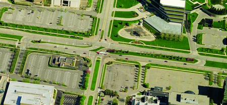
PDF files can be viewed with the Acrobat® Reader® This document is a technical summary of the Federal Highway Administration report, Alternative Intersections/Interchanges: Information Report (AIIR) (FHWA-HRT-09-060). ObjectiveToday's transportation professionals, with limited resources available to them, are challenged to meet the mobility needs of an increasing population. At many highway junctions, congestion continues to worsen, and drivers, pedestrians, and bicyclists experience increasing delays and heightened exposure to risk. Today's traffic volumes and travel demands often lead to safety problems that are too complex for conventional junction designs to properly handle. Consequently, more engineers are considering various innovative treatments as they seek solutions to these complex problems. The corresponding report, Alternative Intersections/Interchanges: Informational Report (AIIR) (FHWA-HRT-09-060), covers four intersection designs and two interchange designs. These designs offer substantial advantages over conventional at-grade intersections and grade-separated diamond interchanges. The AIIR provides information on each alternative treatment and covers salient geometric design features, operational and safety issues, access management, costs, construction sequencing, and applicability. This TechBrief summarizes information on one alternative intersection design-the restricted crossing U-turn (RCUT) intersection (see figure 1).
Figure 1. Photo. RCUT intersection in Troy, MI. IntroductionThe RCUT, also referred to as the superstreet intersection or J-turn intersection, is characterized by the prohibition of left-turn and through movements from side street approaches as permitted in conventional designs. Instead, the RCUT intersection accommodates these movements by requiring drivers to turn right onto the main road and then make a U-turn maneuver at a one-way median opening 400 to 1,000 ft after the intersection. Left turns from the main road approaches are executed in a manner similar to left turns at conventional intersections and are unchanged in this design (see figure 2). Left-turn movements from the major road could also be removed at primarily rural unsignalized RCUT designs.
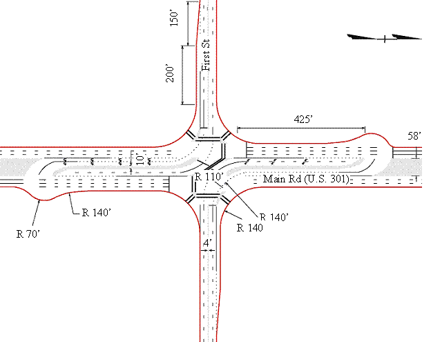
Figure 2. Illustration. Typical RCUT plan view with crossovers on mainline approaches. RCUT intersections have been constructed in several States following the introduction of the concept in the early 1980s.(1) An RCUT at a location in Michigan is shown in figure 1. Other installations include three unsignalized RCUT intersections on U.S. Route 301 on Maryland's Eastern Shore and two on U.S. Route 15 in Emmitsburg, MD. One of the Emmitsburg, MD, installations is shown in figure 3. RCUT intersections have also been recently installed at several locations in North Carolina, including a 2.5-mi stretch of U.S. Route 23/74 in Haywood County, where three RCUT intersections were installed. Five RCUTs were also installed on Route 1 in Lee and Moore Counties, and three were installed on a signalized corridor of U.S. Route 17 in Brunswick County.
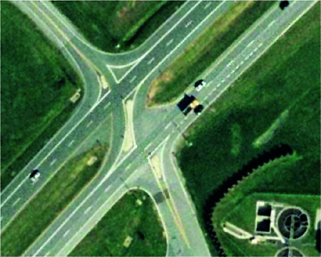
Figure 3. Photo. U.S. Route 15 RCUT intersection in Emmitsburg, MD. Geometric DesignGeometric aspects of RCUT intersections can vary, but a typical design is shown in figure 2 and discussed as follows:
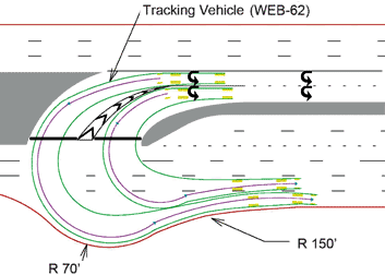
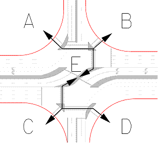
Figure 4. Illustration. Movement in a loon at a crossover that features two
Figure 5. Illustration. Pedestrian movements in an RCUT intersection. Traffic Signal ControlOne typical design (as in figure 2) of an RCUT intersection may have three distinct intersections operating under traffic signal control with just two phases and relatively short cycles. Signal warrants provided in the Manual on Uniform Traffic Control Devices (MUTCD) provide key guidance on the justification for signal control at the locations where U-turns are made.(3) One theoretical benefit of the RCUT intersection is that signal controllers for one direction of the arterial could be operated independently of the signal controllers for the opposite direction of the arterial. It is also feasible to use one controller for the three signal locations. Operational PerformanceThe traffic simulation software VISSIM was used to compare the operational performance of RCUTs to conventional intersections. Five RCUT designs were modeled for three traffic scenarios and compared to conventional intersections. For the case where the minor flow was less than 0.2 of the total flow, simulation results indicated the following:
Safety PerformanceRCUT intersections have 18 conflict points compared to 32 at conventional intersections. The RCUT intersection appears to offer substantial safety advantages over conventional intersections. For example, for the RCUT intersections on the U.S. Route 23/74 corridor in North Carolina, there was a 17-percent decrease in total crashes, a 31-percent decrease in total crash rate, a 41-percent decrease in fatal/injury crashes, and a 51-percent decrease in fatal/injury crash rate. Higher reductions were observed for the three unsignalized RCUTs that replaced conventional intersections on the Eastern Shore of Maryland. For the U.S. Route 17 corridor in North Carolina, total crash rates were found to be lower than the 10-year average for 25 signalized conventional intersections in Charlotte, NC, with comparable annual average daily traffic. ApplicabilityRCUT intersections are typically implemented as part of a corridor treatment; however, they can be used at isolated intersections. Unsignalized RCUT intersections preserve corridor capacity and can be installed without the adverse effects of signal control. Scenarios where RCUT intersections are most applicable include the following:
SummaryRCUT intersections reroute minor street left-turn and through movements to an MUT crossover and thereby provide major advantages, including reduced delay and congestion for through traffic on the major road and reduced opportunities for crashes compared to conventional designs. More details on the RCUT intersection can be found in the full AIIR available from the Federal Highway Administration. References
|