Prediction of the Expected Safety Performance of Rural Two-Lane Highways
APPENDIX D
DEFINITIONS OF ROADSIDE HAZARD RATINGS USED WITH THE ACCIDENT PREDICTION ALGORITHM
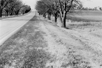
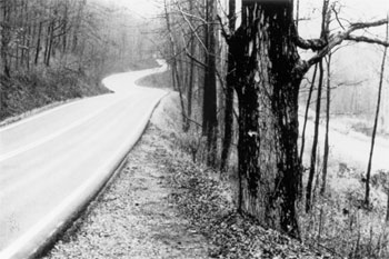
The accident prediction algorithm uses a roadside hazard rating system developed by Zegeer, et al. to characterize the accident potential for roadside designs found on two-lane highways.(6) Roadside hazard is ranked on a seven-point categorical scale from 1 (best) to 7 (worst). The seven categories of roadside hazard rating are defined as follows:
Rating = 1
- Wide clear zones greater than or equal to 9 m (30 ft) from the pavement edgeline.
- Sideslope flatter than 1:4.
- Recoverable.
Rating = 2
- Clear zone between 6 and 7.5 m (20 and 25 ft) from pavement edgeline.
- Sideslope about 1:4.
- Recoverable.
Rating = 3
- Clear zone about 3 m (10 ft) from pavement edgeline.
- Sideslope about 1:3 or 1:4.
- Rough roadside surface.
- Marginally recoverable.
Rating = 4
- Clear zone between 1.5 and 3 m (5 to 10 ft) from pavement edgeline.
- Sideslope about 1:3 or 1:4.
- May have guardrail (1.5 to 2 m [5 to 6.5 ft] from pavement edgeline).
- May have exposed trees, poles, or other objects (about 3 m or 10 ft from pavement edgeline).
- Marginally forgiving, but increased chance of a reportable roadside collision.
Rating = 5
- Clear zone between 1.5 and 3 m (5 to 10 ft) from pavement edgeline.
- Sideslope about 1:3.
- May have guardrail (0 to 1.5 m [0 to 5 ft] from pavement edgeline).
- May have rigid obstacles or embankment within 2 to 3 m (6.5 to 10 ft) of pavement edgeline.
- Virtually non-recoverable.
Rating = 6
- Clear zone less than or equal to 1.5 m (5 ft).
- Sideslope about 1:2.
- No guardrail.
- Exposed rigid obstacles within 0 to 2 m (0 to 6.5 ft) of the pavement edgeline.
- Non-recoverable.
Rating = 7
- Clear zone less than or equal to 1.5 m (5 ft).
- Sideslope 1:2 or steeper.
- Cliff or vertical rock cut.
- No guardrail.
- Non-recoverable with high likelihood of severe injuries from roadside collision.
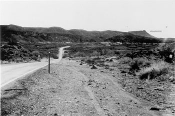
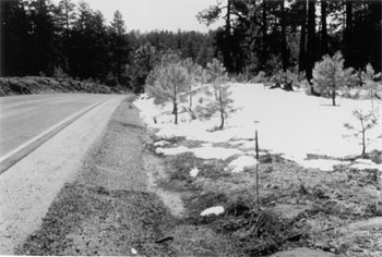
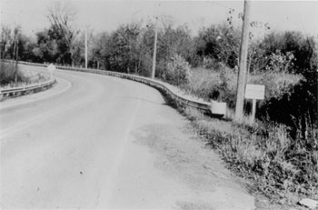
Figures 8 through 14 present photographs illustrating the seven roadside hazard rating categories.
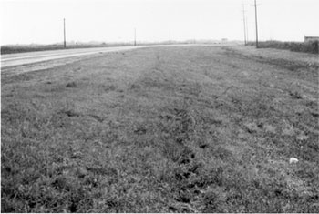 |
| Figure 8. Typical Roadway with Roadside Hazard Rating Equal to 1. |
 |
| Figure 9. Typical Roadway with Roadside Hazard Rating Equal to 2. |
 |
| Figure 10. Typical Roadway with Roadside Hazard Rating Equal to 3. |
 |
| Figure 11. Typical Roadway with Roadside Hazard Rating Equal to 4. |
 |
| Figure 12. Typical Roadway with Roadside Hazard Rating Equal to 5. |
 |
| Figure 13. Typical Roadway with Roadside Hazard Rating Equal to 6. |
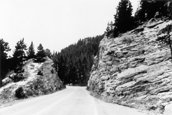 |
| Figure 14. Typical Roadway with Roadside Hazard Rating Equal to 7. |
Previous | Table of Contents
|


