|


- HOME -
|
Current Research
Contact: Ann Do
Federal Highway Administration
6300 Georgetown Pike, HRDS-7
McLean, VA 22101
Phone: 202-493-3319
E-mail: ann.do@dot.gov
Program Goal
The goal of this program is to improve pedestrian and bicycle safety,
operations, and mobility through a comprehensive program of data collection
and analysis, engineering and countermeasure developments and evaluation,
promotion and public awareness, and technology transfer. The program
will lead to improved pedestrian and bicyclist programs, planning
tools and engineering implementation guides, policies, and standards
for use at national, State, and local levels.
Scope and Objectives
This program is being sponsored in cooperation with the National Highway
Traffic Safety Administration (NHTSA). As part of a first step towards
developing the Pedestrian and Bicyclist Research Program Plan, the
objectives developed and used in evaluating proposed projects and
defining the scope of the program plan were to:
- Enhance our understanding of these problems and needs associated
with walking and bicycling.
- Enhance our understanding of how best to design and/or select
facilities to accommodate pedestrians and bicyclists.
- "Institutionalize" pedestrian and bicyclist considerations in
the regular ongoing policies, plans, standards, and programs of
Federal, State, and local transportation agencies.
- Assist highway design engineers in determining how best to accommodate
pedestrian and bicyclists in new and retrofit highway projects.
- Enable transportation planners to develop high-quality, long-range
pedestrian and bicyclist plans and to asses proposed alternatives
in terms of the potential for modal shift and air-quality impacts.
- Package and disseminate information and countermeasures in such
a way as to encourage widespread application.
- Provide State and local transportation, planning, and highway
safety professionals with information on, and access to, the tools
they need to implement projects and programs for pedestrian and
bicyclists.
Background
In recent years, the Federal Highway Administration (FHWA) has been
developing a new, expanded statement of policy regarding the non-motorized
modes of transportation - walking and bicycling. In speeches by the
Administrator, memos to the regional and division administrators,
and, most significantly, in the congressionally mandated National
Bicycling and Walking Study, the FHWA has taken the position that
bicycling and walking are transportation modes that have too long
been the "forgotten modes" and that this should change.
The National Bicycling and Walking Study goals are to:
- Double the percentage of all trips made by bicycling or walking.
- Reduce the current number of bicycling and walking injuries and
fatalities by 10 percent.
These are potentially conflicting goals unless research intervenes
to reduce the risk of bicycling and walking per unit of exposure.
This multi-year pedestrian and bicyclist research
and development plan is designed to contribute to the achievement
of both goals. The plan is based on a careful analysis of the desired
outcomes for safety and use, the nature of safety-related problems,
the current understanding of factors affecting the use of non-motorized
modes, the needs of State and local transportation practitioners,
and the current state of the practice.
1. Development of Pedestrian and Bicyclist Injury Databases
This project sought to obtain more complete information on the causes
of injury to pedestrians and bicyclists. The usual source of information
on these events is police crash reports. However, many injuries to
pedestrians and bicyclists are not reported on state motor vehicle
crash files. These include injuries that occur off public roadways
(in parking lots, parks, driveways, etc.), those that do not involve
a motor vehicle (falls from bicycles, collisions between bicyclists
and pedestrians, pedestrian trips on curb), and others that for one
reason or another fail to get reported. The goal of this project has
been to learn more about these non-roadway and non-motor vehicle events
and how they contribute to the overall pedestrian and bicyclist injury
problem.
Data were collected on over 2500 injured pedestrians and bicyclists
treated at eight hospital emergency rooms. The emergency rooms represented
a mix of urban and suburban/rural sites in three states -- California,
New York, and North Carolina. Results show that, overall, 70 percent
of the reported bicycle injury events and 64 percent of the reported
pedestrian injury events did not involve a motor vehicle. In addition,
31 percent of the bicyclists and 53 percent of the pedestrians were
injured in non-roadway locations. For pedestrian only events, 24%
occurred in roadways, 51% on sidewalks, and 14% in parking lots.
Parking lots were especially hazardous to pedestrians in icy weather
conditions. For bicyclist-only events, 54% occurred in roadways,
21% on sidewalks, 9% on trails or other off-road paths, and only
2% in parking lots. In contrast, 88% of pedestrian-motor vehicle
and 92% of bicycle-motor vehicle events occurred in the roadway.
A comparison of the emergency-room reported cases with police-reported
cases revealed that only 56 percent of the pedestrian-motor vehicle
and 48 percent of the bicycle-motor vehicle emergency room cases
were reported on state motor vehicle crash files. Programs to improve
the safety of pedestrians and bicyclists need to take into account
the large numbers of pedestrians being injured in non-roadway and
non-motor vehicle events, and need to examine data sources in addition
to police crash data. The final report (Injuries
to Pedestrians and Bicyclists: An Analysis Based on Hospital Emergency
Department Data - FHWA-RD-99-078) provides more details
of the study.
2. Development of a National Pedestrian Safety Awareness Campaign
(w/NHTSA)
The goal of the pedestrian safety awareness project is to make both
motorists and pedestrians more safety conscious and to increase the
demand for and acceptance of pedestrian safety initiatives. The ultimate
goal is the reduction of deaths and injuries to pedestrians. The core
strategy of this project is to coalesce public and private highway
safety organizations into a partnership (Partnership
for a Walkable America) that will enable walking issues to become
a greater part of highway safety priorities and that can endure beyond
the life of this project.
The project is working with the partnership to develop and initiate
an awareness effort that would be implemented at the national and
state and local levels. The project is developing a limited number
of materials in the form of masters. Materials address the general
problem as well as selected issues within pedestrian safety including
child pedestrians, alcohol and walking, elderly pedestrians and the
concept of empowering pedestrians to be change agents (identifying
unsafe aspects of the walking environment and creating change, such
as improved access, traffic calming, etc.). Products completed to
date include a walkability checklist, promotional pedestrian fact
sheets, feature stories on children, alcohol, and seniors, print advertisements,
and promotional materials for a "Walk
a Child to School" campaign.
3. Development of Planning Guidelines and Training Courses
The objectives of this study are to (1) provide local communities
with guidelines for planning bicycle and pedestrian facilities; (2)
provide State and local transportation agency planners with training
on how to develop the ISTEA-mandated bicycle and pedestrian long range
plan and transportation improvement program elements; and (3) provide
university faculty with course and lesson plans (and materials) covering
key issues related to the non-motorized modes. The course on the ISTEA-mandated
bicycle and pedestrian long range plans and improvements was developed
and taught a total of 12 times throughout the U.S. and no further
courses are planned at this time. The final version of the "Implementing
Bicycle Improvements at the Local Level" has been published. The final
version of the "Implementing Pedestrian Improvements at the Local
Level" is under review by FHWA. The University Course Student Guide
and Instructor's Guide have been developed and are being reviewed.
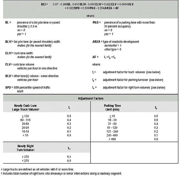
4. The Bicycle Compatibility Index:
A Level of Service Concept
The University of North Carolina Highway Safety Research Center, under
the sponsorship of the Federal Highway Administration (FHWA), has
developed a tool for practitioners to use in assessing the bicycle
compatibility of their roadways. The Bicycle Compatibility Index (BCI)
can be used by bicycle coordinators, transportation planners, traffic
engineers, and others to evaluate existing facilities in order to
determine what improvements may be required as well as determine the
geometric and operational requirements for new facilities to achieve
the desired level of bicycle service.
Bicyclists' perceptions are the key to determining compatibility.
Presently, there is no methodology widely accepted by engineers, planners,
or bicycle coordinators that helps them to determine how compatible
a roadway is for allowing comfortable and efficient operation of both
bicycles and motor vehicles. Determining how existing traffic operations
and geometric conditions impact a bicyclist's decision to use or not
use a specific roadway is the first step in assessing the bicycle
compatibility of the roadway.
The BCI methodology was developed for urban and suburban roadway
segments (i.e., midblock locations that are exclusive of intersections).
The resulting model incorporates variables bicyclists typically use
to assess the "bicycle friendliness" of a roadway (e.g., curb lane
width, traffic volume, and vehicle speeds). The model was developed
using the perceptions of adult bicyclists (aged 19 and older) and
thus, may not be appropriate for assessing conditions with respect
to youth bicyclists. The index values produced by the model indicate
bicyclists' comfort levels.
The BCI can be used to establish level of service for bicycling.
Currently, the Highway Capacity Manual provides no level
of service (LOS) criteria for bicycles. However, the definition of
the LOS according to the manual is founded on the concept of users'
perceptions of qualitative measures that characterize the operational
conditions of the roadway. Two of the terms used in the manual to
describe LOS are comfort/convenience and freedom to maneuver. Both
terms are applicable to bicyclists and are directly reflected in the
BCI since the rating scale used by the study participants was an indication
of comfort level.
Using the BCI values based on data collected at various locations
in the U.S., LOS designations were established for LOS A through LOS
F. As shown in table 1, LOS A (represented by an index < 1.50) indicates
that a roadway is extremely compatible (or comfortable) for the average
adult bicyclist while LOS F (represented by an index > 5.30) is an
indicator that the roadway is extremely incompatible (or uncomfortable)
for the average adult bicyclist.
The BCI model can be used in a variety of applications.
The bicycle compatibility index (BCI) model in table 2 and LOS designations
provide bicycle coordinators, transportation planners, traffic engineers,
and others the capability to better plan and design bicycle compatible
roadways. Specifically, the BCI model can be used for the following
applications:
- Operational Evaluation - Existing roadways can be evaluated
using the BCI model to determine the bicycle LOS present on all
segments. This operational evaluation is useful in several ways.
First, a bicycle compatibility map can be produced for the bicycling
public to show them the LOS they can expect on each roadway segment.
Second, roadway segments or "links" being considered for inclusion
in the bicycle network system can be evaluated to determine which
segments are the most compatible for bicyclists. In addition, "weak
links" in the bicycle network system can be targeted, and prioritization
of sites needing improvements can be established based on the index
values. Finally, alternative treatments (e.g., addition of a bicycle
lane vs. removal of parking) for improving the bicycle compatibility
of a roadway can be evaluated using the BCI model.
- Design - Designers can assess new roadways or roadways
which are being re-designed or retrofitted to ascertain if they
are bicycle compatible. Planned geometric parameters and predicted
or known operational parameters can be used as inputs to the model
to produce the BCI value and determine the bicycle LOS that can
be expected on the roadway. If the roadway does not meet the desired
LOS, the model can be used to evaluate changes in the design necessary
to improve the bicycle LOS.
- Planning - The model provides the user with a mechanism
to quantitatively define and assess long-range bicycle transportation
plans. Data from long-range planning forecasts can be used to assess
the bicycle compatibility of roadways in the future using projected
volumes and planned roadway improvements.
Table 1. Bicycle Compatibility Index (BCI) ranges associated
with level of service (LOS) designations and compatibility level
qualifiers.
| LOS |
BCI Range |
Compatibility Level 1 |
| A |
 1.50 1.50 |
Extremely High |
| B |
1.51 - 2.30 |
Very High |
| C |
2.31 - 3.40 |
Moderately High |
| D |
3.41 - 4.40 |
Moderately Low |
| E |
4.41 - 5.30 |
Very Low |
| F |
 5.30 5.30 |
Extremely Low |
1
Qualifiers for compatibility level pertain to the average adult bicyclist.
A user's guide for the BCI is available. - Please contact
Ann Do to
receive a hardcopy of the user's guide.
The results of this research effort are documented in two FHWA
documents. The Bicycle Compatibility Index: A Level of Service
Concept, Implementation Manual (FHWA-RD-98-095) provides practitioners
with a guide to using the BCI methodology along with several real-world
examples. Development of the Bicycle Compatibility Index: A
Level of Service Concept, Final Report (FHWA-RD-98-72) documents
the research project including validation of the video data collection
technique, field data collection procedures, and results of the
data analysis. Click here for the excel workbooks with the BCI
in metric and English units.
BCI Workbook - metric
BCI Workbook - English
For more information about this research effort and the subsequent
reports, please contact:
Ann Do , Federal Highway Administration
Phone: 202-493-3319
E-mail: ann.do@dot.gov
5. Bicycle Facilities Evaluation
The primary objective of the Bicycle Facilities Evaluation project
is a comprehensive analysis of bicycle lanes (BLs) versus wide
curb lanes (WCL's). Bicyclists riding in either a BL or WCL were
videotaped as they proceeded through BL and WCL intersections
with varying speed and traffic conditions in the U.S. cities of
Gainesville, FL; Santa Barbara, CA; and Austin, TX. The videotapes
were coded to learn about operational and safety characteristics.
Operational characteristics pertained to how bicyclists maneuvered
through the sites, while safety characteristics pertained to conflicts
with motor vehicles, other bicycles, or pedestrians. A conflict
was defined as an interaction between a bicycle and motor vehicle,
pedestrian, or other bicycle such that at least one of the parties
had to change speed or direction to avoid the other. Exposure/experience
data were also collected separately from the videotaping at each
of the data collection sites in each city through use of a short
oral survey. This was information about the age, gender, race,
helmet use, levels of experience, etc. of the cyclists riding
through these intersections.
Bicycle Lanes vs. Wide Curb Lanes: Operational and Safety Findings and Countermeasure Recommendations (FHWA-RD-99-035) provides a summary of the study. More details can be found in the final report
A Comparative Analysis of Bicycle Lanes vs. Wide Curb Lanes: Final Report
(FHWA-RD-99-034).
Contact Ann Do at ann.do@dot.gov for hard copies of these documents.
6. Capacity Analysis of Pedestrian and Bicyclist Facilities
The primary objective of this study was to develop recommended changes to the pedestrian and bicycle analysis procedures in the Highway Capacity Manual. This research effort has resulted
in new procedures for pedestrians and bicycles.
The study also resulted in draft procedures for the analysis of pedestrians
and bicycles in the signalized intersection chapter. Documents
containing the procedures for Chapters 9 (Signalized Intersections),
13 (Pedestrians), and 14 (Bicycles) have been completed. The procedures
have also been submitted to the Highway Capacity Committee of
TRB and approved, and are currently being incorporated into the
2000 Manual.
7. Development and Test of Bicycle Safety Countermeasures
(NHTSA)
The purpose of this Task Order is to identify the types of bicycle/motor
vehicle crash problems and the countermeasures available for them.
The result will be a resource guide that describes available materials
in a matrix format so that bicycle safety planners and engineers
can identify appropriate countermeasures for their specific problems.
Where no countermeasures exist, detailed specifications for a
countermeasure will be prepared and included in the resource guide.
The guide will be developed and evaluated with input from bicycle
safety experts. A summary report was written and approved on the
role of alcohol in bicycle crashes. In addition, a summary report
on bicycle/motor vehicle crash types was written and approved.
The resource guide and final report have been prepared and are
available on CD. Contact Marv Levy for more information at 202/366-5597 or
mlevy@nhtsa.dot.gov.
8. Synthesis of Bicycle and Pedestrian Planning at the State
and MPO Levels
The objectives of this study are: (1) to collect the planning
documents prepared by States and MPOs relating to bicyclists and
pedestrians, and other appropriate information required to produce
the analyses and reports described in this statement of work;
(2) to review these documents for their responsiveness to Federal,
State, and local legislation, regulations, guidelines, policies,
and procedures, and their suitability for promoting the mobility
and safety of pedestrians and bicyclists; (3) to produce a "Synthesis
of the State of the Practice" in bicycle and pedestrian planning
at the State and metropolitan levels; (4) to produce a "Synthesis
of Best Practices" in bicycle and pedestrian planning efforts
at the State and metropolitan levels; (5) to assess the likelihood
that the new state and MPO bicycle and pedestrian plans will lead
to actions or projects that enhance the mobility and safety of
bicyclists and pedestrians; and (6) to provide recommendations
on possible changes in Federal, State, and local legislation,
regulations, guidelines, policies, and procedures to improve the
transportation planning process and to promote the mobility and
safety of bicyclists and pedestrians. The Final Report has been
completed and is available from FHWA. The report is designed as
a guide to the current state-of-the-practice in bike/ped planning,
and features "best practices" based on the 200+ state and MPO
plans which were reviewed. The "guide" is a concise, graphic-rich
publication designed to educate, inspire, and assist practitioners.
9. Evaluation of Pedestrian Facilities
The objective of this research study was to develop and test both
traditional and innovative engineering treatments related to pedestrian
accidents and operations, and to recommend those that should be
utilized under various traffic and roadway conditions. The specific
treatments evaluated include crosswalks, sidewalks/walkways,
speed humps, street narrowing, illuminated pedestrian push buttons,
and infrared pedestrian detectors. The study results could lead
to revisions to the MUTCD, state guidelines for handling pedestrians,
and other recommended practices.
This project has produced three major products. First, updated
Pedestrian Syntheses reports will be written; next, a research
report which documents the results of accident
and operational evaluation of the various pedestrian treatments; and a "Pedestrian Facility Users Guide," provides guidance to engineers and planners on the specific
pedestrian treatments most appropriate for a given situation.
The Pedestrian Synthesis report documenting
pedestrian research in the U.S. will be available in Summer 2000. Take a look at syntheses from other countries (i.e.,
Canada, the United Kingdom, Australia, The Netherlands, and Sweden).
Observational evaluations (including video taping) have been conducted
for various treatments. This includes data from Sacramento, CA,
Buffalo, NY, Corvallis, OR, Tucson, AZ and Richmond, VA on crosswalks.
Video data has been collected in the before and after period for
infrared and microwave pedestrian detectors in Los Angeles, CA,
Phoenix, AZ, and Rochester, NY, illuminated pedestrian push-buttons
in Windsor, Ontario, and traffic calming measures in Cambridge,
MA, Seattle, WA and Portland, OR. Several draft reports are in
various stages of completion. An analysis was conducted of "walking
along roadway " crashes in North Carolina, and a formal TRB paper
has been written and accepted for presentation and publication
by TRB. Data for approximately 1,000 crosswalk sites with control
sites have been collected in 30 U.S. cities to quantify the effects
of marked vs. unmarked crosswalks, and data analysis is now underway.
Progress has also been made on the Pedestrian Facilities User
Guide, including compiling and documenting information on about
25 "success stories", or case studies of pedestrian improvements
around the U.S.
10. Evaluation of the Effectiveness of 3D/4D Visualization
The results of an evaluation of the effectiveness of using 3-D/4-D
visualization in highway design on a project in Florida are presented
in CD-ROM format. The CD documents a 3D visualization project
related to pedestrian and bicycle improvements in Key West, Florida.
The CD-ROM contains an overview of the Key West study; the design
alternatives presented to the public an Key West; discussions
of the visualization research focus, requirements, and process;
and the evaluation results from both the public presentation and
design standpoints. Contact Ann Do for a copy.
11. ITS Applications for Pedestrian Safety
ITS technologies for pedestrian safety are documented on a Web
page Pedsmart. These technologies allow passive
pedestrian detection, provide feedback to the waiting and to the
crossing pedestrian, and increase motorist awareness. The web
page will discuss devices such as flashing crosswalks, audible
signals, countdown signals, infrared detectors, and microwave
detectors.
12. Guidebook on Quantitative Methods to Estimate Non-Motorized
Travel
This study developed a comprehensive guidebook
that documents the available methods for estimating bicycle and
pedestrian trips to be used by researchers, planners, and others
who need to apply such methods to estimate trips for the purpose
of facility planning. The guidebook contains basic information
about the various methods and compare the different approaches.
A summary of the various methods is provided in
Guidebook on Methods to Estimate Non-Motorized Travel: Overview of
Methods. Background information regarding the methods is
provided in Guidebook on Methods to
Estimate Non-Motorized Travel: Supporting Documentation.
13. Pedestrian and Bicycle Crash Analysis Tool (PBCAT)
PBCAT is a software product intended to assist state and local
bicycle coordinators, planners, and engineers. PBCAT accomplishes
this goal through the development and analysis of a data base
containing details associated with crashes between motor vehicles
and pedestrians or bicyclists. One of these details is the crash
type which describes the pre-crash actions of the parties involved.
In the 1970's, methods for typing pedestrian and bicycle crashes
were developed by NHTSA to better define the sequence of events
and precipitating actions leading to bicycle-motor vehicle crashes.
This method has evolved over time and was refined as part of the
development of this software package. The crash typing methodology
included in PBCAT allows the user to quickly determine the crash
type through a series of on-screen questions about the crash and
the maneuvers of the parties involved.
PBCAT will enable practitioners to generate valuable information
for promoting bicycle and pedestrian safety and designing safer
facilities where bicyclists, pedestrians, and motor vehicles interact.
The software is designed with recommended countermeasures linked
to specific bicycle and pedestrian crash types, and contains user-friendly,
on-line instructions and help features along with a user's manual.
Go to http://www.walkinginfo.org/facts/pbcat/index.cfm?/pc/pbcat.htm
to register for PBCAT.
14. Evaluation of Intersection Treatments for Pedestrians
& Bicycles
The objective of this study is to determine the safety and operational
effects of various pedestrian and bicyclist facilities. Innovative
treatments are being evaluated.
The goal will be to identify effective countermeasures and produce
descriptions so that other communities will be interested in replicating
these treatments.
Evaluations have been conducted of four intersections in Sacramento
County, California where pedestrian countdown signals are being
installed. Six sites in New York state and one in Portland, Oregon
were used to evaluate a sign (with traffic cone to be placed
in the centerline of the street) which says, "YIELD TO PEDESTRIANS
IN CROSSWALK." A neon flashing sign "STOP FOR PEDESTRIANS IN CROSSWALK"
has been evaluated at three sites in Tucson, Arizona. Other candidate
treatments included bicycle boxes in Portland and Eugene, Oregon,
and a shared bike lane situation in Eugene. These results will be available Summer 2000.
15. Evaluation of Ultraviolet Headlamps
The safety benefits of ultraviolet headlights (UVA) are being
evaluated. In one study - When asked to count skip lines, subjects
were able to see 49% further with the UVA headlights as compared
to conventional low beam headlights. Sixty percent of the participants
gave the UVA headlights an "excellent" rating, while only 8% of
participants rated the low beam headlights as "excellent". Stationary
pedestrians were detected and recognized 15-60% further with lighter
colors performing the best. The one, walking pedestrian was detected
150% sooner with the addition of UVA headlights
The most recent FHWA evaluation of UVA is being conducted by
Virginia Tech. This effort began with a kick-off meeting in March
1998. Virginia Tech will be conducting further evaluations of
the UVA technology at its soon-to-be-completed Smart Road Facility
in Blacksburg, VA. VATech will also be outfitting 100 vehicles
with the UVA headlamps in order to obtain user feedback and performance
data from a limited number of data recording systems. This effort
will also attempt to obtain the support of the automobile, the
materials, and the headlamp manufacturers. VATech is currently
involved in the development of the workplan. A large-scale demonstration
of the project is being planned for the year 2000.
Also, the Center for Applied Research (CAR) will be conducting
an evaluation of overhead ultraviolet lamps is being conducted
to include overhead UVA and UVA work zone lighting. Overhead UVA
lighting for pedestrian facilities has never been tried before,
so this will really be a feasibility study. Minnesota DOT has
evaluated UVA lighting in work zones with some success. The CAR
effort will concentrate on improving worker safety with UVA.
For more information contact John
Arens at john.arens@fhwa.dot.gov or 202/493-3364.
16. Pedestrian and Bicyclist Technology Transfer
The objective of this project was to develop a technology transfer
system by which the knowledge gained through the FHWA Pedestrian
and Bicycle Safety Research Program will be distributed to transportation,
health, and safety professionals; walking and bicycling advocates;
and the general public who would like for their communities to
be places where they can walk or bike. This system has been developed
using the Web site format for grouping information and testing
progressions of information to determine the most effective means
for linking users with information relevant to their specific
needs. The comprehensive content, organization of information,
and links to specific information are the products of
this project. The structure has been developed,
and work is underway to begin developing specific sections of
the site. Visit the
Pedestrian and Bicycling Information Center at
www.bicyclinginfo.org to see the results. |