U.S. Department of Transportation
Federal Highway Administration
1200 New Jersey Avenue, SE
Washington, DC 20590
202-366-4000
Prepared by:
Office of Highway Policy Information
Federal Highway Administration
Options/Recommendations:
1. Frequency of submitted/reported IRI data.
2. Consistency of submitted/reported IRI data.
3. Collect additional pavement data items and drop less useful ones.
Options/Recommendations
Truck Volume Data
Since states already collect this information to meet the TMG guidelines that 30 percent of all volume counts should be classification counts, the requirement would be to report the actual truck AADTs for two categories of trucks, single unit and combinations. The percent single unit and combination trucks during the peak hour would continue to be reported for all sample sections. The vehicle classification categories on the HPMS Summary Form will be redefined to agree with the single unit trucks definition of categories 4-7.
States would be required to report average truck volumes that represent average conditions for that location. This means that the actual truck counts obtained would need to be adjusted just as volume data is adjusted to represent average conditions or an AADTT as promoted in the 2001 TMG. States would be allowed to use existing procedures or may need to develop an interim process to adjust raw truck count data to represent average conditions until their traffic monitoring programs have collected sufficient data to calculate reliable AADTTs.
Research may be needed on a process to easily calculate truck AADTs, to standardize peak hour definitions, explore use of ITS technology, and relevance to truck commodity surveys.
This additional data collection activity would not be added to HPMS reporting requirements. Other sources of this data would be used by those that have a need for it from State procedures. Another option would be to use either the State’s process or the values used by their pavement design section to estimate future axle loadings derived from existing truck loading information to estimate future truck traffic.
Truck Parking
Information on truck parking facilities may be available from other sources, such as Rand McNally, and would not be added to HPMS. Other databases and publications illustrating locations and descriptions of truck routes and other information useful to truckers may be a source of truck parking information.
Options/Recommendations
Highway surveillance systems
There are other sources of information for this data besides HPMS that
should be used. These data items would be deleted from HPMS.
Overridden capacity values may already exist at the state or may need to be a separate calculation. The edit routines in the submittal software would be changed so that the V/SF calculations of less than 1.4 would be acceptable as accurate data. States would be asked to explain their process for calculating capacity and the override values reported in HPMS.
It appears that coding K and D factors is not an issue for States since this data is readily available from existing databases including many off State system locations. States are encouraged to continue using existing procedures for collecting this data based on guidance from the Highway Capacity Manual and other documents. Since capacity is usually not an issue on lower functional classes, estimates currently being used appear to meet the user needs. It is recommended that there be no change in the collection and coding of this data for HPMS.
Widening feasibility
Since this is already a data item, a better description of how to code it would be developed for both data collectors and data users. The number of lanes that could be added would still be coded and if widening is not feasible, then code the features that are an obstacle to widening.
Information would be developed on the cost to widening, which features could be eliminated to allow widening, and the cost to eliminate these features. States would identify obstacles within a specific distance from the roadway that would greatly complicate widening, and report this condition as a separate data item.
This would be a new data item to add the number of lanes in the counter-peak direction.
Options/Recommendations
Boundaries:
HPMS needs to evolve towards a geo-spatial data submission format in which HPMS data records are linked to a well-defined geo-spatial highway network base map: therefore, many of the geographic identifier fields in the current HPMS record will become unnecessary. Geo-spatial analysis tools will be further developed to allow the data to be selected and summarized by any geographic area. CAUTION: Geo-spatial (i.e., GIS) analysis techniques enable spatially referenced data to be summarized by any geographic area, as long as that area has well defined geographic boundaries, represented in a geo-spatial database. Additional efforts would be best spent to assist States that were unable to reach a satisfactory level of geo-spatial reporting.
Adjustments to the latest Census-defined urban and urbanized area boundaries would be optional by State. The minimum default boundaries would be the most recent Census-defined urban and urbanized area boundaries. If a State chooses to adjust boundaries, then it would be given a very tight schedule (TBA) for submitting them following the release of information from Census.
After a grace period (TBA) and with no submittal of revised boundaries since the last decennial Census, FHWA would proposed to use the latest Census-defined urban and urbanized area boundaries to bump out existing adjusted urban and urbanized area boundaries as well as to define any new small urban or urbanized areas in order to prepare the HPMS data for purposes such as Highway Statistics, performance trends, etc. One of the HPMS goals is to maintain consistency of definitions for performance trends and Highway Statistics as well as use by the general public.
States that submit their HPMS data using a geo-spatial format would not be required to report the following data items on each HPMS record: Donut Sample (Item 7), Rural/Urban Designation (Item 13), Urbanized Area Code (Item 15), Nonattainment Area Code (Item 16). These data items, along with Urban/Rural and Nonattainment Area expansion factors, would be calculated automatically by FHWA as part of the HPMS data preparation process. Those States that do not submit their HPMS data using a geo-spatial format would continue to code these geographic identifiers in each HPMS data record.
| Functional System Code | Code |
|---|---|
| Principal Arterials: | |
| Interstate | 1 |
| Other Freeways & Expressways | 2 |
| Other | 4 |
| Minor Arterials | 6 |
| Collectors (Major) | 7 |
| Minor Collectors | 8 |
| Locals | 9 |
Functional Classes (Item 17) would be consolidated to eliminate the distinction between urban and rural classes (i.e. a segment could be coded as “minor arterial”, not “urban minor arterial” or “rural minor arterial.” Classes could be reduced to only Interstate, Other Freeways & Expressways, Other Principal Arterials, Minor Arterials, Collectors (Major), Minor Collectors, and Locals. The Major Collectors in rural and Collectors in urban would be combined under one code. Those States that do classify public roads as Minor Collectors could as an option report them as Minor Collectors in HPMS. Any public roads not classified as Arterials or Collectors would be classified as Locals.
States would classify all the facilities that are considered Freeways & Expressways in urban and rural. The rural/small urban/urbanized area information would be reported in the Rural/Urban Designation Item or as part of the geo-spatial code.
Update the Functional Classification Guidance and applicable administrative instructions and provide the appropriate functional classification training to staff.
The generated functional system (Item 18)would be dropped.
Any decision for reporting the non-centerline facilities, i.e., ramps and other intermittent auxiliary roads, as well as number of lanes and AADT on them would be stated in the Interchanges paper. Development of some functional class guidance for coding of non-centerline auxiliary facilities may be considered if such facilities are to be reported (see Interchanges paper). No decision has been made to add any other private roads, except those that already are considered as public roads because they serve the public, i.e., toll facilities that operate under the State’s or local government’s blessing.
Options/Recommendations
Metadata
The pavement metadata that are being proposed describe the processes used for collecting and reporting the IRI data. These data would need to be expanded if additional pavement data items are added to HPMS. Also, if the IRI requirements are changed, some of these data items could be eliminated. It has been proposed that the following data items be optional with the submittal of the 2006 HPMS data in June 2007 and required for the data reported in 2008 and beyond:
Adherence to provisional standard AASHTO PP37-04 (yes, no, partially)
Like the pavement metadata, the reporting of traffic metadata would also be optional in 2007 and required in 2008 and beyond. These data primarily look at compliance of the State’s traffic data collection processes with those outlined in the Traffic Monitoring Guide (TMG) and the Traffic Management Systems for Highways (TMS/H) guidance produced by FHWA.
Government Ownership Code
Finally, it is being proposed that the Governmental Ownership code be changed to match the coding of Ownership in the NBI. Governmental Ownership would be changed from a one to two digit field with the following coding options:
| 01 — State Highway Agency | 63 — Bureau of Fish and Wildlife |
| 02 — County Highway Agency | 64 — U.S. Forest Service |
| 03 — Town or Township Highway Agency | 66 — National Park Service |
| 04 — City or Municipal Highway Agency | 67 — Tennessee Valley Authority |
| 11 — State Park, Forest, or Reservation Agency | 68 — Bureau of Land Management |
| 12 — Local Park, Forest, or Reservation Agency | 69 — Bureau of Reclamation |
| 21 — Other State Agency | 70 — Corps of Engineers (Civilian) |
| 25 — Other Local Agency | 71 — Corps of Engineers (Military) |
| 26 — Private (other than railroad) | 72 — Air Force |
| 27 - Railroad | 73 — Navy/Marines |
| 31 — State Toll Authority | 74 — Army |
| 32 — Local Toll Authority | 75 — NASA |
| 60 — Other Federal Agency (not listed below) | 76 — Metropolitan Washington Airports Service |
| 61 — Indian Tribal Government | 80 — Unknown |
| 62 — Bureau of Indian Affairs |
Toll Facility Identifier
The FHWA Office of Highway Policy Information will develop the toll facility codes as part of developing the new data model, and published in the 2007 Toll Facility Report. Data on toll facilities are proposed to be collected in a separate table in HPMS as outlined in the new data model. Each toll facility will be represented as single record with a beginning and ending LRS, and the toll facility code.
Options/Recommendations
A few of the recommendations voiced by the state DOT’s and FHWA are listed below regarding data quality for new data elements and existing data.
New Data Model
State DOT’s are hoping that the use of already-existing GIS-based databases from each state will allow for a smoother transition for the new data requirements. The pilot program, which is described in the Data Model issue paper, along with input from a team of State GIS and HPMS staff should help insure that the new data model will not be extensively burdensome for most States.
Field Manual
The guidance to the States in the HPMS Field Manual appears to be the source of some data consistency and quality concerns. The Office of Highway Policy Information will work with the data users and data providers to rewrite the Field Manual as part of the HPMS Reassessment. The revised Field Manual will employ additional, more detailed descriptions and where appropriate, more illustrations. Whenever possible, actual State examples will be incorporated. A team of data users and State data providers will be put together to rewrite the manual. The target completion data for the new Field Manual is December 2007.
Oversight
Each state DOT will continue to work with their District offices and data collection contractors to guarantee that the data is collected correctly and timely and is input properly for submittal.
The new risk assessment based HPMS Field Reviews will be conducted by FHWA Division Offices on an annual basis. These reviews will focus less on reviewing actual data and more on the data collection and reporting processes. Staffing and SPR program reviews will also be included in these reviews. The detection of possible program deficiencies will trigger a more in-depth process review. The results of the Field Reviews are to be submitted to the Office of Highway Policy Information by November 1st.
Data Validation
FHWA will continue to improve its validation software to make certain that invalid data does not appear within any field in the database (e.g., a 4 is not coded in a field with valid inputs of 1, 2, or 3). FHWA will also work with users of the HPMS data to determine if/what invalid data may be appearing in the database that is sent to the users.
The role of the validation software should be reviewed, especially in light of the data falsification that appears to be taking place in order to resolve data verification errors. The verification software is intended to improve data quality, but it appears that in some instances it is doing just the opposite. FHWA needs to determine the extent to which this is happening, and if there is anything that can be done at the administrative level to alleviate this. This appears to be as much an education and outreach issue as it is a data validation issue.
Options/Recommendations
There are two possible approaches to disaggregating the current HPMS submittal file that have been discussed in the outreach workshops and in subsequent webinars. While there are some subtle differences between the two approaches, they both are essentially the same and both would employ the same data model. The first would create multiple tables within the HPMS submittal similar to the current table that States submit. These tables would be functionally grouped, comma delimited files. These files would then be combined through a process known as dynamic segmentation within the HPMS software using the State provided geospatial networks and the State’s LRS. The uniformity of the LRS across the tables would be critical for this method to be successful. An advantage of using comma-delimited files is that the existing HPMS software, especially the Oracle database, would not require major changes. As the Reassessment has progressed, this previous statement has proven to not be entirely correct. While it is true that converting the HPMS database from a flat-file database to a geospatial database would be a sea change, both would require about the same level of effort. It appears at this time that converting the database to a geospatial database would provide benefits exceeding any extra costs that might be incurred.
Currently, LRS is only collected on Principal Arterials and the NHS. It is being proposed that this would be expanded to include all functional classes through rural Major Collector and urban Collector, since this would cover all roads that are eligible for federal funds. The States’ geospatial networks would also need to include all these roads. It was initially thought that this might be a concern for some States, especially for those sample sections off the State network, but in the workshops and webinars most States indicated that they have a complete geospatial network or networks through Major Collector. A couple of States indicated that they have two separate networks, one for State system roads and the other for off-State system roads. The HPMS software and database would probably be able to handle two networks and data for one State, but this will need to be explored further in the pilot.
The second approach that is being considered would allow States to submit their HPMS data as a GIS file or geospatial database with multiple layers; each layer representing a logical grouping of data (pavement, traffic, ITS etc). As previously mentioned, from the FHWA perspective, this is the desired approach. Most States indicated that they would be supportive of providing the HPMS data in a GIS format; with most agreeing that this is probably the best method to employ for future data submittal. However, there were a few States that indicated that they would have trouble linking data for sample sections off the State highway system to their existing State network. Additionally, there are a couple of States that currently would not be able to provide data in a GIS format. Most, if not all of these States did indicate that changing HPMS to a GIS format might provide the impetus that they need to develop a State GIS system, which most seemed to feel was desirable.
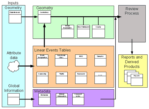
Figure 1 - Data Model
It’s possible to implement this approach while still allowing States to submit their data in the current format. Depending on how the HPMS database is structured, the submittal file could be used as submitted, or it could be disaggregated. The possibility also exists for States to submit a disaggregated file for the sample and universe sections on the State highway system along with a second file, in the current format, for those sample sections off the State highway system. This would be more complicated to implement within the HPMS software and database, but would likely be easier for many States since these data for the HPMS sections off the State highway system often only exist in the State’s HPMS database, and not in the State’s separate management systems. This will have to be explored as part of the pilot.
The Submittal Package
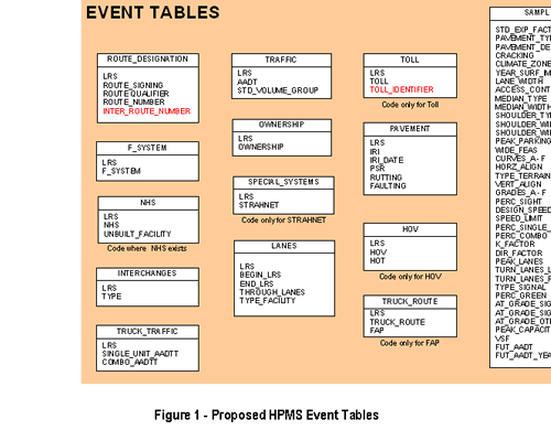
The submittal package would include a geometry file in the form of a shapefile or other acceptable format that has measured and calibrated routes. The package would also contain a series of event tables. These tables would contain the core of the HPMS data that would link to the geometry file. For example, the Lanes table will have a record that has the LRS, BEGIN_LRS, END_LRS, THROUGH_LANES, and TYPE_FACILITY. The LRS field would serve as a common identifier that would be used for linking all data tables and attaching them to the State provided geospatial network.
The submittal package would also contain a Global Information which would include information that applies to every record such as Units, Year or Data, Summary data etc. This would also include the comment letter and submittal history information.
While States are welcome to use an existing public or commercial network, FHWA is not at this time considering using a single network (TIGER, Commercial) to create a national backbone network. The benefits of using State provided networks out weigh the costs associated with creating and maintaining a national backbone network. While FHW does have a business need for a routable national network, the primary geospatial need is for State networks that can be used for integrating various datasets and for performing data analysis at the State level and national level. Since States are already maintain a geospatial network for their own business needs, it makes sense to modify HPMS to use these networks rather than duplicating this effort at the national level for a very minimal increase in geospatial data analysis and reporting capabilities.
The following are the requirements for the State geospatial networks. It should be noted that these recommendations take into consideration the comments provided by the data users and data providers in the Reassessment workshops and webinars. At this time, FHWA is not prepared to further define the many other “attributes” of the State geospatial networks. The State pilot will attempt to identify those network attributes that need to be standardized in HPMS. Data providers and data customers not involved in the State pilot are encouraged to submit their recommendations on additional network standards.
Maintenance — The proposed data model will use the State supplied geospatial networks, which need to correspond to the HPMS data being submitted that year. To insure a 100% match between the HPMS data and the geospatial network, States are encouraged to submit a new network every year.
Options/Recommendations
Below is a summary and discussion of various recommendations and options for consideration in the current HPMS reassessment effort or for future consideration and study. The basic sampling scheme for HPMS is not recommended for significant change at this time. Below are three sections into which the issues are separated: Immediate implementation is applicable only to #1 below, short-term study is applicable for #2 (completed by September 2007), and long term study is recommended for the remainder until which time a further/future in-depth study can be made.
Immediate Implementation
Universe/Summary AADT: Present scheme of sampling within urbanized areas, small urban areas, and rural by functional system and by volume strata could be retained (a study proposal should be scheduled for a future years when more research monies would be expected to be available). The State should report estimated AADT’s at least within a special study area(s) to populate the rest of the Minor Arterials and Collectors (Major) universe not already reported with AADTs (Data Item 33) for any NHS or STRAHNET or standard sample segment in order to avoid having to develop donut areas and add donut samples. If this would be an acceptable option, the Donut Area Sample AADT Volume Group Identifier (Item 31) as well as the entire donut sampling procedure could be deleted. FHWA also proposes to include AADT (Item 33) as a required item for all reported Federal-aid highway segments. Inclusion of AADT for all Minor Arterials and Collectors (Major) segments would greatly simplify the estimation of VMT for specific geographic areas as well as nonattainment or maintenance areas by pollutant. Currently, only the standard and donut samples required AADTs to be reported on all Minor Arterials, rural Major Collectors, and urban Collectors. Please note that AADT reporting was already required on a universe basis for all Principal Arterials and NHS and STRAHNET and samples on Minor Arterials, rural Major Collectors, and urban Collectors.
The current Summary Template used for the air quality nonattainment & maintenance areas would be modified to accommodate reporting a combined estimate of DVMT for the lowest systems by area and pollutant; these lowest systems would include any rural Minor Collectors and rural/urban Locals located within the nonattainment or maintenance area. The Donut scheme would be deleted in favor of reporting estimated AADTs in special study areas to populate the rest of the AADT cells on the minor arterials and collectors (major) segments that are not already samples or part of the NHS or STRAHNET.
The statisticians need to make a recommendation how to keep the sample panel representative of the entire urbanized area in cases where large additions are added to an existing urbanized area sample panel. The Urbanized Area Sampling Technique (Item 14) would be dropped. A decision needs to be made regarding allowance of sub-area sampling within a large urbanized area.
Item 48 — Donut Area Sample Expansion Factor — eliminated
Short Term Study
AADT volume group strata adjustment: FHWA proposes establishing a single AADT Volume Group (Item 32) stratification that would apply across all geographic area types (i.e., rural, small urban, urbanized, nonattainment, etc.) The suggested AADT volume group strata shown below should be evaluated to determine the impact of various options (i.e., wider volume ranges as the volume increases, use same volume ranges across urban/rural, etc.). AADT volume group strata adjustment should be tested to determine the impact of various options (i.e., wider volume ranges as the volume increases, use same volume ranges across urban/rural, etc.). The expectation is that this change has the green light. A generic set of common AADT Volume Groups is recommended. Adjustments in volume ranges might be made if the studies confirm further change is needed.
| AADT Volume Groups | Code |
|---|---|
| Under 500 | 1 |
| 500 — 1,999 | 2 |
| 2,000 — 4,999 | 3 |
| 5,000 — 9,999 | 4 |
| 10,000 — 19,999 | 5 |
| 20,000 — 34,999 | 6 |
| 35,000 — 54,999 | 7 |
| 55,000 — 84,999 | 8 |
| 85,000 — 124,999 | 9 |
| 125,000 — 174,999 | 10 |
| 175,000 — 249,999 | 11 |
| 250,000 and more | 12 |
Item 32 — Standard Sample AADT Volume Group Identifier -- Common generic AADT Volume Groups
Long Term (Future) Study
National sample: Further exploration of obtaining additional items on a sample basis for the non-Federal-aid Highways would be looked at most likely on a case study basis. No final decision has been made.
Alternative sampling methods: Alternative variable schemes, if viable, could be reviewed and proposed. Levels of precision needed for FHWA purposes need to be visited, since the level of precision directly affects the amount of samples required. If a commitment is made, than criteria would be very helpful in deciding the alternative schemes as well as the appropriate levels of precision to employ.
NHS sample: A NHS sampling scheme by State would be implemented using the existing standard samples supplemented with extra standard samples where needed. A separate Item would be retained for the NHS expansion factor as like the standard sample expansion factor. An in-depth analysis is needed to verify the proposed results. Also, a decision would need to be made whether to sample on the NHS Locals and Rural Minor Collectors. A final decision should be made regarding the scheme and levels of precision. Nobody has stated which HPMS Items would be applicable with the National sampling scheme; this needs to be worked out.
New Item — NHS Expansion Factors (applicable to the non-Interstate parts)
Geospatial expansion factors: When the results of a study of allowing expansion factors to be created separately for each set of items reported by a particular shop are available, then appropriate decisions can be made.
Item 16 — NAAQS Nonattainment/Maintenance Code (option) -- These items would not be needed for States that submit HPMS using a geospatial format — It could include up to 6 possible pollutants using the EPA-named area name (entry means yes the segment is within the affected area).
Sample size formula: No decision has been made of the exploration of the sample size formula and how it is used to calculate the required sample size within each volume group. Logically, it should be considered early if some fine tuning adjustments are to be taken.
| << Previous | Contents |

