U.S. Department of Transportation
Federal Highway Administration
1200 New Jersey Avenue, SE
Washington, DC 20590
202-366-4000
Prepared by:
Office of Highway Policy Information
Federal Highway Administration
This section describes and summarizes the changes that were originally developed through the Issue papers and later released in the draft HPMS Reassessment Recommendations report in January 2007.
Beginning in the spring of 2006, issue papers were developed for each of the major subject areas of the Reassessment. The purpose of the issue papers was to convey to the HPMS community the data changes being considered in the Reassessment, thus providing the data providers and users with firm recommendations on which they could provide FHWA comments. The 10 Issue paper areas were grouped into three categories as follows:
For clarification, collecting year refers to the year in which the data are collected, where reporting year refers to the year in which these data are reported to FHWA. HPMS data are expected to be collected over a one-calendar-year period and be reported to FHWA by the following June 15th. For example, data collected by a state in calendar year 2006 is reported to FHWA on June 15, 2007. The timing for HPMS data changes is very important and there are four basic levels of changes being made in the Reassessment:
There are a number of data recommendations studied in the Reassessment that were ultimately not adopted. Of these recommendations, a number have been identified for future study, and are categorized in this report under each section as “Deferred for Future Research.”
Sections 4.1, 4.2, and 4.3 summarize the recommendations for the structure of HPMS, data items, and data quality/process improvement respectively. The results were used to arrive at recommendations regarding level of effort to change and/or add certain items. Section 4.4 summarizes all of the recommendations in a table format.
This section deals with the changes to the structure of HPMS, which includes the database and methods of submitting HPMS data to FHWA. These changes directly address two of the HPMS goals to evolve HPMS to a data system which:
The ability to connect HPMS data items with a common geo-referencing system was also identified as an outstanding need in the last Reassessment. An important mission of this Reassessment is to capitalize on changing technology to enhance quality, efficiency, and data integration.
The three main areas being considered in Section 4.1 are a new data model, sampling, and boundaries/functional classification.
The basic concept for a new data model was originally proposed in an Issue paper and further described in the draft report. The primary objectives of the data model are:
The data model will accomplish these objectives by organizing the HPMS data into program areas, and link them together through a Geographic Information System (GIS) using spatial relationships. The new model treats each data item independently, thus removing all unnecessary data dependencies inherent in the old data model. Each data item could be represented by its own layer with its own rules.
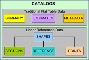
The overall structure of HPMS will be organized in catalogs representing different levels of data detail. Summary data are represented in tables within the Summary Catalog, Section specific data is represented in the Sections Catalog. The Shapes Catalog holds the key to linking the data together through polygon and polyline geometric files. The specific data structure and reporting requirements are identified in the HPMS Data Specifications.
Figure 4.1 Conceptual Overview of the New Data Model
The structure for the HPMS of 2010 goes a long way toward achieving the goal of HPMS being built from the data systems of local, regional, and state governments, and connected with a common geo-referencing system. The Data Model has the following attributes:
The changes are to:
The general recommendations that were evaluated include:
It was concluded that the basic standard sampling scheme for HPMS remain unchanged. Benefits of applying the following changes as described include the:
The following changes are for immediate implementation:
The following were considered and discussed in the Reassessment webinars and workshops and ultimately deferred. The availability of qualified staff and the reduction in the Reassessment budget ultimately led to the conclusion to defer these for future research. Some of these could easily be implemented, while others should be addressed as part of a future Reassessment.
The suggested AADT volume group strata shown in the table below should be evaluated to determine the impact of various options (i.e., wider volume ranges as the volume increases, use same volume ranges across urban/rural, etc.). AADT volume group strata adjustment should be tested to determine the impact of various options (i.e., wider volume ranges as the volume increases, use same volume ranges across urban/rural, etc.). States were generally in favor of this change, but once again, FHWA was not able to complete an in-depth study of the impact of implementing this change; however, FHWA felt compelled to make the change based on a minimum analysis anyway.
| Code | AADT Volume Groups |
|---|---|
| 1 | Under 500 |
| 2 | 500-1,999 |
| 3 | 2,000-4,999 |
| 4 | 5,000-9,999 |
| 5 | 10,000-19,999 |
| 6 | 20,000-34,999 |
| 7 | 35,000-54,999 |
| 8 | 55,000-84,999 |
| 9 | 85,000-124,999 |
| 10 | 125,000-174,999 |
| 11 | 175,000-249,999 |
| 12 | 250,000 and more |
The benefits of moving from State adjusted urban/urbanized boundaries to a different boundary (i.e. Census, or MPO) were discussed. The general consensus among the States and the data users was that adjusted urban/urbanized boundaries were preferred. Most often, the reason cited was the fact that adjusted urbanized boundaries are “transportation” oriented, meaning they have been adjusted to capture transportation characteristics not represented in the Census or MPO boundaries. Ultimately no change was made to the urban/urbanized boundaries, but it was agreed that FHWA would need to take a more active role in providing guidance to the States following the next decennial Census.
Eliminating the urban versus rural designation from highway functional classification and collapsing the number of classification codes from the current 12 to 7 will improve the accuracy and consistency of these data. Since the inception of functional class, the coding of these data has had both a rural/urban component and a functional component. Unfortunately, how a road functions is not necessarily related or dependent on it being urban or rural. Removing the rural/urban bifurcation will eliminate the need to update the functional class field whenever a change occurs in an urban or urbanized area boundary, and will hopefully lead to more consistent reporting of highway functional classes across and within States. The revised set of functional classes and associated codes are shown in the table below.
| Code | Functional Class Description |
|---|---|
| 1 | Interstate |
| 2 | Other Freeways & Expressways |
| 3 | Other Principal Arterial |
| 4 | Minor Arterial |
| 5 | Major Collector |
| 6 | Minor Collector |
| 7 | Local |
Research options for updating the geo-spatial information of the current urban and urbanized areas and air quality boundaries.
The following data items are being modified or added to better meet FHWA business needs. The business needs have been discussed in detail earlier in this report. For background information, review the appropriate Issue papers in Appendix C: for safety, pavements, interchanges, freight and capacity. For a list of items giving data names and structures, the HPMS Reassessment 2010+ Data Specification document can be referenced.
Changes for of each of the main areas are detailed below.
The mandatory Reporting Year for the following data is 2010 unless otherwise indicated in parenthesis.
Motorcycles (2008 Reporting Year)
Beginning in 2008, the reporting of motorcycle travel data for data year 2007 is mandatory. All States are expected to begin reporting motorcycle travel data as a percent of total travel in the area wide summary table.
FHWA realizes that there are currently some concerns about the quality and consistency of these data. The concerns are often centered on the ability of traffic equipment to detect motorcycles, when and where States typically count traffic, and the methods used for factoring short-term counts. FHWA is committed to working with the States to help improve the quality of these data through the dissemination of best practices, revised guidance, training, and modifications to existing equipment, or research into new equipment and technologies.
Coordination of HPMS with other Safety Databases
The Office of Safety and the Office of Highway Policy Information will continue to coordinate regarding HPMS and Minimum Inventory of Required Elements (MIRE) standards. The new data model has been modified for States who wish to provide FHWA with some or all of their MMIRE to do so at the time they submit their HPMS data. These optional data would not be considered HPMS data, and would only receive a cursory review; these data would be passed along to the FHWA Office of Safety.
IRI data
Interchanges
Ramps
Truck Volumes as Universe Data on the NHS
Highway surveillance systems (2009 Reporting Year)
Capacity calculations
Widening Obstacle
Widening Potential
Counter-Peak Lanes
K and D — Factors
Truck Volume Data
The discussions at the workshops and webinars identified a concern for improving the quality of the data provided by state and local governments and for process improvements. These recommendations will be initiated by FHWA to assist the data providers to improve the overall quality and consistency of the data and to improve the quality of the analysis and use for FHWA business purposes. Exploration of data quality and process improvement ensures adherence to afore mentioned HPMS and Reassessment goals.
Field Manual
The guidance to the states in the HPMS Field Manual appears to be the source of some data consistency and quality concerns. The Office of Highway Policy Information is working with data users and data providers to rewrite the Field Manual as part of the HPMS Reassessment. The revised Field Manual will employ additional, more detailed descriptions and where appropriate, more illustrations. Whenever possible, actual state examples will be incorporated. A team of data users and state data providers will be put together to rewrite the manual. The target completion data for the new Field Manual is fall 2008.
Data Validation
FHWA will continue to improve its validation software to make certain that invalid data does not appear within any field in the database (e.g., a 4 is not coded in a field with valid inputs of 1, 2, or 3). FHWA also will work with users of the HPMS data to determine if/what invalid data may be appearing in the database that is sent to the users.
Oversight
The review of the HPMS validation software should be an ongoing activity, especially in light of the data adjustments that appear to be taking place in order to resolve data verification errors. The verification software is intended to improve data quality, but it appears that in some instances it is encouraging just the opposite. FHWA needs to determine the extent to which this is happening, and if there is anything that can be done at the administrative level to alleviate this.
Pavement Metadata
The pavement metadata describe the processes used for collecting and reporting some of the pavement data items. Currently States are optionally submitting to FHWA metadata on their IRI data. The IRI metadata are being reduced and additional metadata added for rutting, faulting, and cracking. The metadata are required beginning in data reporting year 2010. A complete list of the pavement metadata can be found in the HPMS Data Specifications.
Traffic Metadata
As with the pavement metadata, the reporting of traffic metadata is required beginning in data reporting year 2010. The traffic metadata focuses on the reporting of quality traffic data in accordance with the HPMS Field Manual, the Traffic Monitoring Guide (TMG), and the Traffic Monitoring System for Highways (TMS/H) regulations. The questions to be answered include:
Government Ownership Code
Finally, it is being proposed that the Governmental Ownership code be changed to match the coding of Ownership in the NBI. Governmental Ownership would be changed from a one to two-digit field with the following coding options:
| Code | Government Agency |
|---|---|
| 01 | State Highway Agency |
| 02 | County Highway Agency |
| 03 | Town or Township Highway Agency |
| 04 | City or Municipal Highway Agency |
| 11 | State Park, Forest, or Reservation Agency |
| 12 | Local Park, Forest, or Reservation Agency |
| 21 | Other State Agency |
| 25 | Other Local Agency |
| 26 | Private (other than railroad) |
| 27 | Railroad |
| 31 | State Toll Authority |
| 32 | Local Toll Authority |
| 40 | Other Public Instrumentality (i.e., Airport, School/University, etc.) |
| 50 | Indian Tribal Nation |
| 60 | Other Federal Agency (not listed below) |
| 62 | Bureau of Indian Affairs |
| 63 | Bureau of Fish and Wildlife |
| 34 | U.S. Forest Service |
| 66 | National Park Service |
| 67 | Tennessee Valley Authority |
| 68 | Bureau of Land Management |
| 69 | Bureau of Reclamation |
| 70 | Corps of Engineers |
| 72 | Air Force |
| 73 | Navy/Marines |
| 74 | Army |
| 80 | Unknown |
Toll Facility Identifier
The FHWA Office of Highway Policy Information will develop the toll facility identifier codes as part of developing the new data model, and published in future Toll Facility Reports. Each toll facility will be represented as single record with a beginning and ending LRS, and the toll facility codes. The toll facility identifier codes will be used for linking the toll sections in HPMS with other FHWA toll databases including the toll facility finance data and the database used for developing the Toll Facilities report.
There are a significant number of data items that have been deleted and changed as a result of the Reassessment. Furthermore, the data model will allow the HPMS software to calculate or derive more data than was done in the existing software. The tables in the following sections list the deleted, changed, calculated, new, and unchanged data items. FHWA provided data are noted where applicable. States are responsible for collecting and reporting the remaining changed, new, and unchanged data items.
Table 4.4.1 shows which of the existing HPMS data items have been deleted or changed. Most of the deleted data items are either a direct result of the new data model or the elimination of the ITS data. It should be noted that Future AADT Year, which is shown as being deleted, still exists in the new data model. However it is now an attribute or metadata for the Future Year data item. The IRI data item now has an attribute for the year IRI was collected which is a new requirement for this data element.
| Deleted Data | |
|---|---|
| Old Data Number | Data Item Description |
| 3 | Reporting Units |
| 5 | Section ID |
| 6 | Is Standard Sample |
| 7 | Is Donut Sample |
| 8 | State Control Field |
| 9 | Is Section Grouped |
| 14 | Urbanized Area Sampling Tech |
| 18 | Generated Functional Sys |
| 21 | Official Interstate Route No |
| 31 | Donut Area Volume Group |
| 38 | Electronic Surveillance |
| 39 | Metered Ramps |
| 40 | Variable Message Signs |
| 41 | Highway Advisory Radio |
| 42 | Surveillance Cameras |
| 43 | Incident Detection |
| 44 | Free Cell Phone |
| 45 | On-Call Service Patrol |
| 46 | In-Vehicle Signing |
| 48 | Donut Expansion Factor |
| 51 | Structural No/Depth |
| 10 | Route ID |
| 11 | Begin Point |
| 12 | End Point |
| 15 | Urban Code |
| 17 | F System |
| 19 | NHS1 |
| 24 | Route Number |
| 25 | Ownership |
| 26 | STRAHNET1 |
| 27 | Facility Type |
| 33 | AADT |
| 35 | IRI |
| 37 | HOV Type |
| 50 | Surface Type1 |
| 52 | Climate Zone1 |
| 56 | Median Type |
| 62 | Widening Potential |
| 81 | Pct Peak Single |
| 82 | AADT Single |
| 83 | Pct Peak Combination |
| 84 | AADT Combination |
| 97 | Future AADT |
| 98 | Future AADT Year |
1 — FHWA provided data items
The new geospatial data model has increased the number of data items that the HPMS software will be able to calculate when putting together the Standard Sample file. Some of these data will be calculated from other data sources within HPMS e.g. metadata, summary tables, or geospatial files. Others will come from the data that States code for individual sections of roadway, which the software will summarize for the Standard Sample sections.
States will also have the option of submitting measured data and having the HPMS software calculate the HPMS, which is described in section 4.4.5.
| Old Data Number | Data Item Description |
|---|---|
| 4 | County Code |
| 13 | Rural/Urban Code |
| 16 | NAAQS Codes |
| 32 | Standard Sample Volume Group |
| 47 | Sample Identifier |
| 49 | Standard Sample Exp Factor |
| 63 | Length Class A Curves |
| 64 | Length Class B Curves |
| 65 | Length Class C Curves |
| 66 | Length Class D Curves |
| 67 | Length Class E Curves |
| 68 | Length Class F Curves |
| 69 | Horizontal Alignment Adequacy |
| 71 | Vertical Alignment Adequacy |
| 72 | Length Class A Curves |
| 73 | Length Class B Grades |
| 74 | Length Class C Grades |
| 75 | Length Class D Grades |
| 76 | Length Class E Grades |
| 77 | Length Class F Grades |
| 79 | Weighted Design Speed |
| 95 | Peak Capacity |
| 96 | Volume/Service Flow Ratio |
Listed below are the new HPMS data items. Most of these data items were discussed in the Issue Papers or during the Reassessment webinars and workshops. However, there are some that were identified much later in the Reassessment, during the development of the data model. An example would be curves and grades, previously discussed in this document. Others are the result of working with the data users and discovering that something new or a little different would better serve their needs. HOV Lanes for example came about through discussions with data users in the Office of Policy and Governmental Affairs, FHWA and the Office of Operations, FHWA. Both groups indicated that knowing the actual number of HOV lanes is very important to their programs.
| Data Item Description |
|---|
| Curves |
| Grades |
| Is Structure |
| HOV Lanes |
| Counter Peak Lanes |
| Special Toll Lanes |
| Route Prefix |
| Route Suffix |
| Alternative Route Name |
| Widening Obstacle |
| Rutting |
| Faulting |
| Cracking Fatigue |
| Cracking Transverse |
| Year Last Construction |
| Last Overlay Thickness |
| Thickness Rigid |
| Thickness Flexible |
| Base Type |
| Base Thickness |
| Soil Type |
It is important to note that even though these data items were not changed or deleted, they did undergo a thorough review and evaluation. Not only was the coding for each item reviewed, but the overall Federal needs for these data were also considered. At no time was it assumed that any data would be “automatically” included. For example, Year Record and State Code are two data items that would appear to be mandatory. However, the HPMS Team within the Office of Highway Policy Information spent much time discussing and evaluating a number of ways to eliminate these data items. The team concluded that while these data are redundant (they appear in every single record) the minor reduction in coding effort was not worth the increased risk of having a data record or records associated with the wrong State and/or year.
| Old Data Number | Data Item Description |
|---|---|
| 1 | Year Record |
| 2 | State Code |
| 20 | Future Facility1 |
| 22 | Route Signing |
| 23 | Route Qualifier |
| 28 | Truck Net1 |
| 29 | Toll |
| 30 | Section Length |
| 34 | Through Lanes |
| 36 | PSR |
| 53 | Year Last Improvement |
| 54 | Lane Width |
| 55 | Access Control |
| 57 | Median Width |
| 58 | Shoulder Type |
| 59 | Shoulder Width R |
| 60 | Shoulder Width L |
| 61 | Peak Parking |
| 70 | Terrain Type |
| 78 | Pct Pass Sight |
| 80 | Speed Limit |
| 85 | K Factor |
| 86 | Dir Factor |
| 87 | Peak Lanes |
| 88 | Turn Lanes L |
| 89 | Turn Lanes R |
| 90 | Type Signal |
| 91 | Pct Green Time |
| 92 | Number Signals |
| 93 | Stop Signs |
| 94 | At Grade Other |
1 — FHWA provided data items
The new data model has been structured to allow States to submit optional data through HPMS to FHWA. Some of these data are directly related to the HPMS data, while others are not. Each type of optional data is briefly described below.
HPMS Optional Data: The first type of optional data is one that FHWA no longer requires, but States would like to have maintained in HPMS. The descriptive data item State_Control_Field is no longer required, but due overwhelming feedback from States to maintain this data item, it has been reclassified as optional data since FHWA does not need it. The other type of optional HPMS data includes raw or unprocessed data that States would like to use to calculate required HPMS data items. For example, States that have the actual locations of stop signs or measurements of pavement grade can submit these data in a supplemental table and have the HPMS software determine the number of stop signs for each sample section or the classes of grades for each sample section. Software tools to provide this type of functionality would be part of a future development.
Non-HPMS Optional Data: The second type of optional data is collected through HPMS for other program offices in FHWA. These data are not reviewed by the HPMS Team and are simply passed along to the program office for which they are collected. The purpose for these data is to address the myriad of data currently being collected by other program offices that also include some of the HPMS data items. By doing this, FHWA hopes to reduce the collection of redundant data and further minimize the data reporting burden for States. This also addresses a long term goal of the Office of Highway Policy Information, which has been to “Collect data once and use it often.”
The majority of HPMS data are associated with a given section of road. Some of these data are required for all roads, while others are only required for a portion of roads. In the existing HPMS data model, the first types of data are called “universe data” while the second types are called “sample data.” The existing HPMS requires States to create sections that are homogenous for certain data. For each section, some of the universe and most of the sample data are either summarized or averaged. The new data model has eliminated the need for these sections and the summarization of data when States prepare their HPMS submittal. For most data items, States are encouraged to submit only actual, measured values and not summarized or averaged data.
The new data model allows States greater flexibility in collecting and reporting their data. The following is a summary of all the data items contained in HPMS.
The new HPMS will be able to determine 97 data items at the highway section level; these data will come from the following sources:
Table 4.7 provides an overview of the HPMS data items, the format of the data value(s), and the source of the data. Numeric data can be either a numeric code indicated by the text “Codes:” prior to the valid codes, or a number entered as a series of nines. For example, a field that allows a number with three digits left of the decimal and two digits right is indicated as “999.99.” The number in the “Text Data” column indicates the number of text or numeric characters permissible. For both numeric and text data, the number of digits and characters indicated is a maximum.
| Data Item | Numeric Value | Text Value | Date Value | Software Calculated |
FHWA Provided |
|---|---|---|---|---|---|
| Year_Record | yyyy | ||||
| State_Code | Codes: 1 - 76 | ||||
| Route_ID | 32 | ||||
| Begin_Point | 99999.999 | ||||
| End_Point | 99999.999 | ||||
| Section_Length | 99999.999 | ||||
| Sample_Identifier | Yes | ||||
| Standard_Sample_Exp_Factor | Yes | ||||
| Standard_Sample_Volume_Group | Yes | ||||
| County_Code 1 | Yes | ||||
| Urban_Code | 99999 | ||||
| Rural_Urban | Yes | ||||
| F_System | Codes: 1 - 9 | ||||
| NonAtt_Code 1 | 99999 | Code | Yes | ||
| NHS | Codes: 1 - 9 | mm/yyyy | Yes | ||
| Future_Facility | Codes: 1 - 2 | Yes | |||
| STRAHNET | Codes: 1 - 2 | mm/yyyy | Yes | ||
| Truck_Net | Code: 1 | mm/yyyy | Yes | ||
| Route_Signing | Codes: 1 - 10 | ||||
| Route_Qualifier | Codes: 1 - 10 | ||||
| Route_Prefix | 2 | ||||
| Route_Number | 99999 | Char(50) | |||
| Route_Suffix | 2 | ||||
| Alternative_Route_Name | 50 (optional) | ||||
| Ownership | Codes: 1 - 80 | ||||
| Facility_Type | Codes: 1 - 5 | ||||
| Is_Structure | Codes: 0 - 1 | ||||
| Through_Lanes | 99 | ||||
| Toll | Codes: 1 - 2 | Toll ID: 20 | mm/yyyy | ||
| Special_Toll_Lanes | Codes: 1 - 2 | ||||
| Turn_Lanes_L | Codes: 1-7 | ||||
| Turn_Lanes_R | Codes: 1-7 | ||||
| Peak_Lanes | 99 | ||||
| Counter_Peak_Lanes | 99 | ||||
| HOV_Lanes | 99 | ||||
| HOV_Type | Codes: 1 - 3 | ||||
| AADT | 999999 | ||||
| Future_AADT | 999999 | yyyy | |||
| Pct_Peak_Single | 99.9 | ||||
| AADT_Single | 999999 | ||||
| Pct_Peak_Combination | 99.9 | ||||
| AADT_Combination | 999999 | ||||
| K_Factor | 99.9 | ||||
| Dir_Factor | 99.9 | ||||
| Peak_Capacity | 999999 | Yes | |||
| Volume/Service_Flow_Ratio | 999.99 | Yes | |||
| Access_Control | Codes: 1 - 3 | ||||
| Lane_Width | 99.9 | ||||
| Median_Type | Codes: 1 - 7 | ||||
| Median_Width | 99.9 | ||||
| Shoulder_Type | Codes: 1 - 7 | ||||
| Shoulder_Width_R | 99.9 | ||||
| Shoulder_Width_L | 99.9 | ||||
| Peak_Parking | Codes: 1 - 3 | ||||
| Widening_Obstacle | Codes: X,A-G | ||||
| Widening_Potential | 9 | ||||
| IRI | 999 | mm/yyyy | |||
| PSR | 99.9 | ||||
| Rutting | 99.9 | ||||
| Faulting | 99.9 | ||||
| Cracking_Fatigue | 99.9 | ||||
| Cracking_Transverse | 99.9 | ||||
| Surface_Type | Codes: 1 - 12 | ||||
| Climate_Zone | Codes: 1 - 4 | Yes | |||
| Year_Last_Improvement | yyyy | ||||
| Year_Last_Construction | yyyy | ||||
| Last_Overlay_Thickness | 99.9 | ||||
| Thickness_Rigid | 99.9 | ||||
| Thickness_Flexible | 99.9 | ||||
| Base_Type | Codes: 1 - 80 | ||||
| Base_Thickness | 99.9 | ||||
| Soil_Type | Codes: 1 - 2 | Yes | |||
| Curves 1 | Codes: 1 - 6 | ||||
| Length_Class_A_Curves | Codes: 1 - 6 | Yes | |||
| Length_Class_B_Curves | Codes: 1 - 6 | Yes | |||
| Length_Class_C_Curves | Codes: 1 - 6 | Yes | |||
| Length_Class_D_Curves | Codes: 1 - 6 | Yes | |||
| Length_Class_E_Curves | Codes: 1 - 6 | Yes | |||
| Length_Class_F_Curves | Codes: 1 - 6 | Yes | |||
| Horizontal_Alignment_Adequacy | Codes: 1 - 4 | Yes | |||
| Terrain_Type | Codes: 1 - 3 | ||||
| Vertical_Alignment_Adequacy | Codes: 1 - 4 | Yes | |||
| Grades 1 | Codes: 1 - 6 | ||||
| Length_Class_A_Grades | Codes: 1 - 6 | Yes | |||
| Length_Class_B_Grades | Codes: 1 - 6 | Yes | |||
| Length_Class_C_Grades | Codes: 1 - 6 | Yes | |||
| Length_Class_D_Grades | Codes: 1 - 6 | Yes | |||
| Length_Class_E_Grades | Codes: 1 - 6 | Yes | |||
| Length_Class_F_Grades | Codes: 1 - 6 | Yes | |||
| Pct_Pass_Sight | 99.9 | ||||
| Weighted_Design_Speed | 99.9 | Yes | |||
| Speed_Limit | 99 | ||||
| Type_Signal | Codes: 1 - 5 | ||||
| Pct_Green_Time | 99.9 | ||||
| Number_Signals | 99 | ||||
| Stop_Signs | 99 | ||||
| At_Grade_Other | 99 |
1 — Data Items not included in Sample Panel.
As previously mentioned, each data item in the new data model is treated as an independent value. This means that when coding the data, States only need to indicate where data are present and where the values change. Each data item will contain five common fields that are used for linking the data to the State provided geospatial network. These linking variables are: Year Record, State Code, Route ID, Begin Point, and End Point. In addition, each record will also contain the variable Section Length.
All data records will have the following format:
Year Record, State Code, Route ID, Begin Point, End Point, Section Length, Data Item Code, Numeric Value, Text Value, Date Value.
For example, the functional classification for Interstate 80 in Nebraska would be coded as:
2009, 31, 80, 0, 455.27, F_System, 1, ,
The HPMS Data Specifications and Field Manual both provide additional examples and instructions on the proper coding of the section specific data.
A primary requirement for HPMS is to provide an input file for various FHWA models including those used to for the Biennial Conditions and Performance Report to Congress, often referred to as the C&P Report. These models include the Highway Economic Requirements System (HERS) and the FAF. The models produce Nationals level estimates of current and future highway system conditions and needs. Statistically accurate results are obtained by modeling highway system use and performance using a set of sample data, which in whole is referred to as the “sample panel.” The sample panel typically comprises roughly 10% of all Federal-aid eligible roads.
The method for determining the sample panel has its roots in standard statistical principles. The number of samples required is based on the variability of the traffic counts (AADT) within a given Functional System. The current HPMS data model requires States to determine each sample and collect the individual data items based on the limits of that sample. Often States have to summarize data for each sample section since most data items don’t have concurrent termini.
The new data model will make greater use of “raw” non-summarized HPMS data and build the sample panel as a view or extract of data that falls within calculated and selected limits. The same statistical principles using AADT will be used to stratify each functional system and determine the number of necessary samples. The limits of the randomly selected samples will be applied to the raw data and values for each data item will be aggregated for each sample section. The sample panel is only a view, so there is no modification or destruction of data. Expansion of the sample sections will not change from the existing data model.
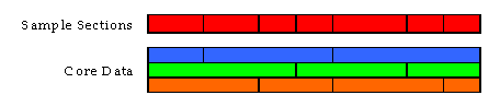
As previously described, the sample panel will be a virtual file or “view” of calculated values within the new data model. The limits of the sample panel are created using a set of “core” data items. The resulting sample sections are homogenous for these core data items. The data model will create a universe of potential sample sections based on the spatial intersection of the core data. These data items are NHS, F_System, Urban_Code, Through_Lanes, Facility_Type, Is_Structure, and AADT. The Ownership data item will be aggregated between state and off-state and be used as the last core data item. Figure 4.6.1 illustrates how breaks in the core data, represented by the orange, green, and blue bars are used to determine the limits for the sample sections represented by the red bar.
Figure 4.6.1 Determining the Sample Sections
As the pool of potential samples is created, volume groups are assigned, and sample adequacy procedures are run to determine the necessary number of samples per volume group. At this point the sample sections are ready to be randomly selected, either by the HPMS software or the State. All efforts are being made to accommodate the use of existing State sample panels within the data model.
Once the sample sections have been selected, the limits of each sample section are used to summarize information from the section data. This is done using the aggregation rules to determine one value that is represents the entire sample section. The data model also uses section data to calculate some additional data fields, which include Capacity, Design_Speed, and Volume/Service Flow.
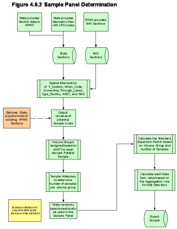
Figure 4.6.2 provides an overview of the process used for creating the Sample Panel.
The following table contains a list of the data items that are used by the data model to create the sample panel. Please refer to the HPMS Data Specifications and HPMS Field Manual for a description of each data item, where they are required, and the proper coding.
| Year Record | Counter Peak Lanes | Rutting |
|---|---|---|
| State Code | HOV Lanes | Faulting |
| Route ID | HOV Type | Cracking Fatigue |
| Begin Point | AADT | Cracking Transverse |
| End Point | Future AADT | Surface Type |
| Section Length | Pct Peak Single | Year Last Improvement |
| Urban Code | AADT Single | Year Last Construction |
| F System | Pct Peak Combination | Last Overlay Thickness |
| Route Signing | AADT Combination | Thickness Rigid |
| Route Qualifier | K Factor | Thickness Flexible |
| Route Prefix | Dir Factor | Base Type |
| Route Number | Access Control | Base Thickness |
| Route Suffix | Lane Width | Terrain Type |
| Alternative Route Name | Median Type | Pct Pass Sight |
| Ownership | Median Width | Speed Limit |
| Facility Type | Shoulder Type | Type Signal |
| Is Structure | Shoulder Width R | Pct Green Time |
| Through Lanes | Shoulder Width L | Number Signals |
| Toll | Peak Parking | Stop Signs |
| Special Toll Lanes | Widening Obstacle | At Grade Other |
| Turn Lanes L | Widening Potential | Curves |
| Turn Lanes R | IRI | Grades |
| Peak Lanes | PSR |
The export of the sample panel in the new data model will be very similar to the existing export function and will be in the same comma separated variable format.
_______________
[1] Donut Area refers to the portion of a non-attainment or maintenance area that is outside an small urban or urbanized area boundary. The Donut Area Sample is a supplementary sample that is used to determine travel in the Donut Area, so when combined with the travel for the small urban or urbanized area, is representative the entire non-attainment or maintenance area.
[2] HPMS Assessment and Review Guidelines for the FHWA Division Offices is available on the HPMS web site at: https://www.fhwa.dot.gov/policyinformation/hpms/reviewguide.cfm
| << Previous | Contents | Next >> |

