U.S. Department of Transportation
Federal Highway Administration
1200 New Jersey Avenue, SE
Washington, DC 20590
202-366-4000
Federal Highway Administration Research and Technology
Coordinating, Developing, and Delivering Highway Transportation Innovations
 |
| This fact sheet is an archived publication and may contain dated technical, contact, and link information |
|
Publication Number: FHWA-HRT-06-135
Date: December 2006 |
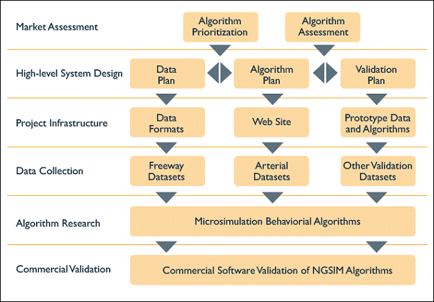
Next Generation SIMulation Fact SheetNGSIM Overview PDF version of Fact Sheet (1.64 MB) Traffic microsimulation models are becoming widely used and valuable tools in modeling existing and planned future transportation networks and conditions. These models can help transportation professionals make important decisions on such topics as new roadway alignments and configurations, new interchange configurations and locations, the addition of freeway auxiliary lanes, work zone management strategies and plans, operational and intelligent transportation system (ITS) strategies and plans, coordination and timing of traffic signals, and the addition of high-occupancy toll lanes. Although many of the microsimulation models used today are robust and provide a wide range of analysis options, some gaps and limitations still exist that can affect the accuracy of their results. Since the 1970s, the Federal Highway Administration (FHWA) has been a leader in the development of traffic simulation models. Before FHWA undertook a leadership role, no commercial traffic simulation packages existed in the marketplace. To help achieve wider acceptance of the use of microsimulation systems and ensure the tools provide accurate results, FHWA's Traffic Analysis Tools Program launched the Next Generation SIMulation (NGSIM) program. NGSIM is a unique public-private partnership between FHWA and commercial microsimulation software developers, the academic research community, and the traffic microsimulation community. In undertaking this partnership, FHWA will act as a market facilitator and use focused public resources to influence and stimulate the commercial simulation market by fostering a cooperative environment of public-private coordination. Figure 1 shows the implementation of the overall NGSIM program. Through the NGSIM program, FHWA will develop several driver behavioral algorithms, along with supporting documentation and validation datasets, which represent the fundamental logic within microscopic traffic simulation models. These algorithms will describe the interactions of multimodal travelers, vehicles, and highway systems and the influence posed by traffic control devices, delineation, congestion, and other features of the environment. FHWA will openly distribute NGSIM products and make them freely available to the transportation community through the NGSIM Web site at http://ops.fhwa.dot.gov/trafficanalysistools/ngsim.htm. These products include:
Figure 1. This flowchart depicts the implementation of the NGSIM program.
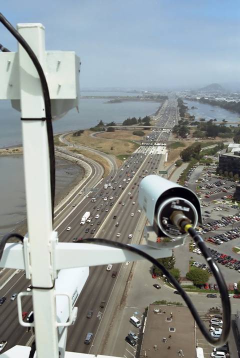
Figure 2. A digital video camera mounted on top of a building that overlooks a highway is recording vehicle trajectory data. From the outset, the NGSIM team sought input and advice from the traffic simulation community through the formation of three stakeholder groups that together represent the different perspectives of the community. These stakeholder groups include a traffic modelers group that represents researchers and others that develop driver behavior models, a software developers group that represents private vendors responsible for developing and maintaining commercial traffic simulation software, and a model users group that represents the practitioners who use traffic simulation models for decisionmaking. The NGSIM team and stakeholder groups first conducted a market assessment of traffic microsimulation models, including identifying their limitations and prioritizing the NGSIM algorithm research needs based on the objective of improving the core behavioral algorithms in microsimulation software. The NGSIM team then formulated high-level plans for collecting data and developing and validating the algorithms. These plans ensured that the research would be conducted through a consistent, rigorous process. The team also provided an infrastructure for free and open sharing of data by developing data formats and a Web site for online dissemination of NGSIM products. The high-level system plans and project infrastructure then enabled the team to proceed with the primary tasks of collecting real-world datasets, developing core simulation algorithms, and validating the algorithms using commercial simulation software. As a result of the core simulation algorithms developed through NGSIM ultimately being incorporated into commercial simulation models, transportation practitioners will be able to use microsimulation software more confidently knowing that traffic simulation experts developed the models' algorithms using high-quality, real-world datasets. Improving the core algorithms ultimately will lead to more reliable and valid transportation decisions, which is critical in the current environment of both shrinking transportation budgets and growing demand for accountable and efficient transportation investments. Enabling reliable and valid transportation decisions through improved traffic simulation modeling is the ultimate goal of the NGSIM program. For more information, visit the NGSIM Web site at http://ops.fhwa.dot.gov/trafficanalysistools/ngsim.htm or contact: John Halkias James Colyar
Publication No. FHWA-HRT-06-135 PDF files can be viewed with the Acrobat® Reader® |
|
Updated: 09/08/2017
|