
Also available as Adobe PDF (400 KB)
The Minnesota Department of Transportation (MnDOT) identified a need to improve the safety and mobility of a segment of eastbound Interstate 94 (I-94) in St. Paul, Minnesota, in the area shown in figure 1.
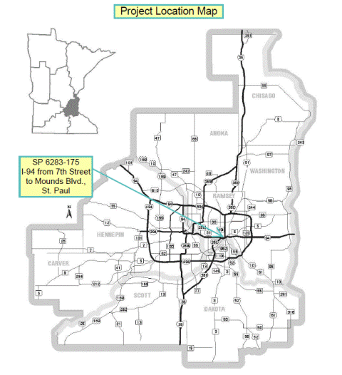
Figure 1. Project location map.
The total project road length is about 1.35 miles in the City of St. Paul, Minnesota. The project was proposed to improve safety and reduce congestion by increasing roadway capacity, provide a smoother ride, improve drainage in the areas, and extend the service life of the roadway, bridges and drainage system. Figure 2 shows an overview of the project area. Specifically, the preferred Build Alternative identified in the Environmental Assessment:
An Environmental Assessment was prepared by MnDOT and the Federal Highway Administration (FHWA) to fulfill requirements of the National Environmental Policy Act (NEPA) and State review process. (FHWA and MnDOT 2014) A Finding of No Significant Impact (FONSI) for this project was signed on February 13, 2015. (FHWA 2015)
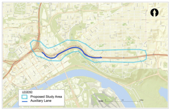
Figure 2. I-94 Auxiliary Lane project area.
MnDOT made the determination that a quantitative MSAT analysis was needed for this project. This decision was made based on the average annual daily traffic (AADT) on the freeway segments affected by this project which have daily volumes ranging from 131,500 to 175,300. As such, the project had a higher potential for MSAT effects, thereby triggering a quantitative MSAT analysis. (FHWA 2012)
MnDOT oversaw the MSAT air quality analysis, was engaged at the project meetings, worked through the MSAT analysis protocol with the consultant, and coordinated with other government agencies. Other agencies involved in the process included the Minnesota Pollution Control Agency (MPCA), the Metropolitan Council, which is the regional Metropolitan Planning Organization (MPO), and FHWA’s Resource Center.
This MSAT analysis was prepared in 2014; construction of the project was expected to take place from 2016 to 2017.
For this project, the project team first performed a trend analysis of MSAT emissions over multiple future years based on the No-Build condition to identify the year with the highest emissions. This trend analysis was conducted over the period from 2015 through 2030 in five-year increments. Additionally, 2016 was modeled as the project opening year. After analyzing the trend in emissions, the team identified 2016 as the year with the worst emissions. 2016 then became the year for which a comparison of the No-Build and Build Alternatives was evaluated. Table 1 summarizes the MSAT emissions trend analysis of the No-Build condition. Table 2 compares the 2016 emission results for both the No-Build and Build Alternative and presents an analysis of the difference in the 2016 Build versus No-Build Alternative emissions. Reported emissions are from the entire Ramsey County roadway network.
| Pollutant | Annual Emissions (lbs) |
Percent Reduction 2015 to 2030 |
|||||
|---|---|---|---|---|---|---|---|
2015 |
2016 |
2020 |
2025 |
2030 |
|||
Acrolein |
2,736 |
2,385 |
1,499 |
1,048 |
868 |
68% |
|
Benzene |
37,093 |
32,091 |
23,193 |
20,445 |
19,081 |
49% |
|
Butadiene |
6,178 |
5,351 |
3,806 |
3,280 |
3,033 |
51% |
|
Formaldehyde |
41,898 |
37,055 |
25,585 |
20,191 |
18,095 |
57% |
|
Naphthalene |
5,388 |
4,706 |
3,162 |
2,463 |
2,173 |
60% |
|
Polycyclic organic matter (POM) |
2,709 |
2,417 |
1,621 |
1,186 |
1,032 |
62% |
|
Diesel particulate matter (PM) |
269,918 |
230,123 |
126,849 |
66,092 |
41,840 |
84% |
|
Source: FHWA and MnDOT 2014. |
|||||||
| Pollutant | Annual Emissions (lbs) |
Percent Change 2016 No-Build to Build Alternative |
|||
|---|---|---|---|---|---|
2016 No-Build |
2016 Build Alternative |
||||
Acrolein |
2,385 |
2,384 |
-0.053% |
||
Benzene |
32,091 |
32,081 |
-0.030% |
||
Butadiene |
5,351 |
5,349 |
-0.032% |
||
Formaldehyde |
37,055 |
37,036 |
-0.051% |
||
Naphthalene |
4,706 |
4,704 |
-0.046% |
||
POM |
2,417 |
2,417 |
-0.009% |
||
Diesel PM |
230,123 |
229,978 |
-0.063% |
||
VMT Total (million miles) |
5,294.6 |
5,296.2 |
0.031% |
||
Diesel VMT (million miles) |
483.3 |
483.4 |
0.031% |
||
Based on the analysis shown in table 2, the project team concluded that no meaningful impacts in MSAT emissions were found between the No-Build and Build Alternatives. The auxiliary lane is expected to attract travel from local roadways to the freeway, leading to increases in speed and a reduction in congestion, which leads to decreases in emissions for all MSAT pollutants. These decreases occurred even though total travel volumes increased slightly.
The primary guidance document used by the project team in developing and carrying out the MSAT analysis for this project was a “Quick-Start Guide for Using the Motor Vehicle Emission Simulator (MOVES) for the National Environmental Policy Act (NEPA) mobile source air toxic (MSAT) Analysis.” (FHWA 2013) This document, developed by the FHWA Resource Center, was provided and presented to the project team at an FHWA MSAT workshop in Minnesota shortly before this MSAT analysis was begun.1
The modeled network in this analysis for both the No-Build trend analysis and the 2016 Build analysis was Ramsey County. Note that this modeled area is much larger than the project area shown in figure 2.2 MnDOT developed traffic forecasts for 2016 for both the Build and No-Build Alternatives. This included average daily traffic (ADT) estimates for key road segments that were identified as having the potential to be affected by the project. These ADT forecasts showed increased volumes on I-94 eastbound as more traffic is attracted from local arterials and alternative routes under the Build Alternative. The contractor then distributed the ADT by hour within the area affected by the project using a 24-hour link-level traffic profile. Hourly volumes for links not affected by the project would be the same as those in the No-Build condition. Once the Build Alternative hourly volumes were established in the project area, the contractor used a volume-delay function from the regional travel demand model to develop link-level travel speeds. Using these updated speeds for the Build Alternative, the contractor was then able to estimate the speed distributions over the entire modeled network (i.e., Ramsey County). The speed distributions do not vary by source type, but do differ by hour and road type.
The U.S. Environmental Protection Agency’s (EPA) MOVES2010b model was used to calculate daily onroad emissions. (EPA 2012) Table 3 summarizes the selections that were made for each of the MOVES parameters in the MOVES Graphical User Interface. These analyses used the MOVES model to calculate hourly emissions over an entire day for each month of the analysis year. The modeled VMT represented total VMT in Ramsey County in the selected year. All expected vehicle type/fuel-type combinations were modeled, for the two urban road types in MOVES. None of the roads in the county were identified as rural roads. Also, following FHWA guidance for MSAT analyses, off-network emissions (calculated by MOVES using the off-network road type) were not included in this analysis.
| Inputs | Selections |
|---|---|
Scale |
Domain/scale: County Calculation type: Inventory |
Time Spans |
Time aggregation Level: Hour Years: 2015, 2016, 2020, 2025, 2030 Months: all 12 Days: Weekdays Hours: all 24 |
Geographic Bounds |
Ramsey County |
Vehicles/Equipment |
All allowable gas and diesel types plus CNG transit bus |
Road Type |
Urban restricted access Urban unrestricted access |
Pollutants |
Total Gaseous Hydrocarbons Non-Methane Hydrocarbons Volatile Organic Compounds Primary Exhaust PM10-Total Primary PM10-Organic Carbon Primary PM10-Elemental Carbon Total Energy Consumption Benzene 1,3–Butadiene Formaldehyde Acrolein Polycyclic Aromatic Hydrocarbons |
Processes |
Running exhaust Crankcase running exhaust |
General Output |
Mass units: Pounds Energy units: Joules Distance units: Miles Activity: Distance traveled |
Output Emissions Detail |
Hour County Fuel Type |
Many of the MOVES data inputs needed for these MSAT analyses were provided by either the MPO or the State air agency (MPCA). For fuel inputs, daily VMT fractions, and inspection and maintenance program data, the MOVES defaults for Ramsey County in the analysis year were used. Inputs that were developed specifically for this MSAT analysis included the average speed distribution, hourly VMT fractions, and Highway Performance Monitoring System (HPMS) VMT for the 2016 Build Scenario. Table 4 shows the input data sources.
| Input | Data Source |
Notes |
|---|---|---|
Age Distribution |
MPO, MPCA |
2012 Minnesota Driver and Vehicle Services (DVS) vehicle registration data for Ramsey County. |
Average Speed Distribution |
MPO |
Build Scenario speed distributions developed based on revised hourly ADT allocations modeled with volume-delay function from regional travel-demand model. |
Fuel Type and Technologies |
MOVES default |
|
Fuel Supply |
MOVES default |
|
Fuel Formulation |
MOVES default |
|
Meteorology Data |
MPO, MPCA |
Ramsey County data for 2012. |
Ramp Fraction |
MOVES default |
|
Road Type Distribution |
MPO |
|
Source Type Population |
MPO, MPCA |
2012 DVS vehicle registration data for Ramsey County; future year based on projection. |
HPMS VMT |
MPO |
MPO travel demand model was run for 2010 and 2030; inputs for other years were estimated using linear growth interpolation by roadway facility. |
Month VMT Fraction |
MnDOT automatic traffic recorder data |
|
Day VMT Fraction |
MOVES default |
|
Hour VMT Fraction |
MPO |
Twin Cities Travel Demand Model VMT data aggregated to MOVES road types. |
I/M Programs |
MOVES default |
Annual emissions were calculated by multiplying the daily emissions for each month from the MOVES output by 30 days and summing over all 12 months for each pollutant.
This analysis shows a general emissions reduction for all seven MSAT compounds from year 2015 to year 2030 in Ramsey County, Minnesota, which is consistent with the national trend. These reductions are primarily due to better fuel efficiency, improvements in vehicle technology, and more stringent emission standards even as vehicle activity increases during this time period.
The Environmental Assessment for this project concludes: “The air quality project impact analysis shows no meaningful difference between the No-Build and Build Alternatives. The additional auxiliary lane proposed by this project will have the effect of attracting traffic from the local roadway systems to the freeway. The localized level of MSAT emissions for the Build Scenario could be higher relative to the No-Build Scenario, but this could be offset by the increase in speed and the reduction in congestion. Also, MSAT will be lower in other locations having reduced traffic volumes. On a regional level, the project’s projected air quality impacts are too small to be considered meaningful.” (FHWA and MnDOT 2014)
MnDOT had previously performed a quantitative MSAT analysis for a project in St. Croix, which was one of the first major quantitative MSAT analyses performed in the country, and as such, MnDOT was familiar in general with the overall process needed to prepare a quantitative MSAT analysis. However, that analysis used MOBILE6 rather than MOVES. This I-94 project also was the first in which the contractor used MOVES in a quantitative MSAT analysis, although the contractor also had previous experience in preparing quantitative MSAT analyses with MOBILE6.
For both the contractor and MnDOT, a recent FHWA training on performing quantitative MSAT analyses along with the “Quick-Start Guide3”(now the Frequently Asked Questions FAQs) were both valuable resources for this analysis. The contractor team used the templates from the “Quick-Start Guide” to provide early information to MnDOT. This allowed for early review of the contractor’s plan by MnDOT and also provided a level of comfort in moving forward with the analysis. (Wasko 2015)
In retrospect, the contractor noted that the customized traffic analysis for the Build Alternative was a reactive approach based on using the existing traffic forecast. The contractor felt that the method used for allocating the changes in ADT by hour and for preparing the speed distributions was fairly complex and resource-intensive, and would likely use a different approach for future projects. Rather than using the process to allocate ADT to the roadways in the study for the Build Scenario and applying a volume delay function to predict hourly speeds on each link, a simpler approach might have been developed by using the MPO’s travel demand model directly in the Build scenario. (Morris 2015)
Using a modeled area consisting of the entire county, for a project that is less than two miles in length, may dilute the effects of the MSAT Build versus No-Build analysis. The subsequent release of FHWA FAQs clarifies the importance of selecting appropriate links for the affected network.
EPA 2012. “Motor Vehicle Emission Simulator (MOVES)—User Guide for MOVES2010b,” EPA-420-B-12-001b, U.S. Environmental Protection Agency Office of Transportation and Air Quality, June 2012.
FHWA 2012: “Interim Guidance Update on Mobile Source Air Toxic Analysis in NEPA,” Federal Highway Administration, December 6, 2012.
FHWA 2013: “Quick-start Guide for Using MOVES for NEPA MSAT Analysis,” Federal Highway Administration Resource Center, prepared for MnDOT, 2013.
FHWA 2015: “Finding of No Significant Impact: Minnesota State Project Number 6283-175, I-94 Reconstruction in the City of Saint Paul, Ramsey County, Minnesota,” U.S. Department of Transportation Federal Highway Administration, Minnesota Division, February 13, 2015, available at http://www.dot.state.mn.us/metro/projects/i94stpaul/pdf/fonsi.pdf.
FHWA and MnDOT 2014: “Environmental Assessment: Interstate 94 Reconstruction in Downtown St. Paul, State Project 6283-175,” U.S. Department of Transportation Federal Highway Administration and Minnesota Department of Transportation, June 2014, available at http://www.dot.state.mn.us/metro/projects/i94stpaul/pdf/environmentalassessment.pdf.
Morris 2015: Paul Morris, SRF Consulting Group, Inc., personal communication with M. Mullen, SC&A, Inc., September 18, 2015.
Wasko 2015: Peter Wasko, Minnesota Department of Transportation, Noise and Air Quality Supervisor, personal communication with M. Mullen, SC&A, Inc.,
September 17, 2015.
1 This information has now been incorporated into FHWA’s “Frequently Asked Questions (FAQ): Conducting Quantitative MSAT Analysis for FHWA NEPA Documents,” FWHA HEP-15-056 available at http://www.fhwa.dot.gov/environment/air_quality/air_toxics/policy_and_guidance/moves_msat_faq.cfm, September 2, 2015.
2 The Quick-Start Guide notes that the affected transportation network “would include the constructed roadway segments, as well as other links where traffic volumes are expected to change as a result of the project… As a practical consideration, a volume change threshold needs to be adopted as the basis for including or excluding links in the affected transportation network. One suggested threshold is a plus or minus five percent change in volumes….” In this case study, the project sponsor decided to model the emission impacts throughout the entire county, which would be a much larger area than might be suggested by the use of a five percent change threshold.
3 This information has now been incorporated into FHWA’s “Frequently Asked Questions (FAQ): Conducting Quantitative MSAT Analysis for FHWA NEPA Documents,” FWHA HEP-15-056 available at http://www.fhwa.dot.gov/environment/air_quality/air_toxics/policy_and_guidance/moves_msat_faq.cfm, September 2, 2015.

