Federal Highway Adminstration
and
Association of Metropolitan Planning Organizations (AMPO)
Air Quality Subcommittee
June 2005
Final Report
One of the transportation conformity requirements is that EPA's latest emission factor model must be used in all regional emissions analysis[1]. In January 2002 the U.S. EPA released a new emissions factor model, MOBILE6. There was a two-year grace period to transition to the new MOBILE model. Effective January 29, 2004, all regional emissions analyses as part of transportation conformity determinations were required to use MOBILE6. Subsequent to the January 2002 version, EPA released an updated version, known as MOBILE6.2. MOBILE6.2 included emissions factors for estimation of particulates, air toxics, and certain greenhouse gases. Use of MOBILE6.2 is now required for all regional emissions analyses, with the exception of California, for ozone and CO. The release of MOBILE6.2 marked the beginning of a 2-year grace period for PM-10 areas to phase-in the new model. Conformity determinations in PM-10 areas must be based on MOBILE6.2 by May 19, 2006[2],[3].
The FHWA, in conjunction with the Association of Metropolitan Planning Organizations (AMPO) Air Quality Subcommittee, worked with a group of MPOs to document their experience in applying MOBILE6 in the conformity process. The purpose of this study is to provide an understanding of what steps these organizations took to prepare for use of the new MOBILE model and to identify potential training and technical assistance needs. Specifically, this study documents how MPOs are implementing MOBILE6, what data is being collected locally, how data is being collected, and identifies implementation issues that arose during the transition to MOBILE6. FHWA and AMPO intend to share this information with other MPOs and practitioners who can learn from the experiences of the MPOs that participated in this effort.
Ten MPOs participated in this project and a variety of approaches to developing inputs to the MOBILE6 model were identified. Although not free of challenges, all the MPOs participating in this study were able to transition to MOBILE6 during the two-year grace period. Many of the areas were also able to revise their SIP motor vehicle emissions budgets with MOBILE6 so that the MOBILE6-based regional emissions analysis was compared to a budget developed with the same model.
MOBILE6 is a major update of EPA's MOBILE series emissions model. Key differences between MOBILE5, the previous version, and MOBILE6 include:
MOBILE 6.2 allows for the estimating of PM10 emissions, air toxics, and certain greenhouse gases. For EPA's guidance on use of MOBILE6.2, the currently required version of MOBILE, see: www.epa.gov/otaq/m6.htm.
MOBILE6.2 provides many improvements over earlier models yet also requires more types and sources of data. EPA has provided national default data that can be used but some metropolitan areas have been collecting certain types of local data.
Ten MPOs agreed to participate in this study.
Contact information, population and the nonattainment/maintenance classification of each MPO region are included in Appendix A.
Each participating MPO was asked to respond to a number of questions that addressed key aspects of implementing MOBILE6: data requirements, collection and sources; interagency consultation, and training and technical assistance needs. A copy of the MOBILE6 questionnaire is provided as Appendix B.
Since not all MPOs answered all the questions, the total number of responses to each question varies.
Three types of data are important inputs to MOBILE6:
Vehicle fleet data is essential to estimating emissions because emissions characteristics vary depending on vehicle age and type. MPOs reported that they use a combination of data sources depending on vehicle type.
Table 1.1 below shows different vehicle fleet data sources used by each participating MPO.
| ARC | Registered fleet distribution data by age developed using R.L. Polk & Company database for all MOBILE6 vehicle types except Class 8b, the heaviest heavy-duty vehicles. MOBILE6 default data is used for Class 8b vehicle registration distribution. MOBILE6 default vehicle mix is used to specify the fraction of total VMT traveled by each vehicle type. |
|---|---|
| BMC | The Maryland Motor Vehicle Administration (MVA) database is used for all 16-vehicle types. The database is used in generating vehicle type, age distribution, and diesel sales fractions within vehicle class. |
| CATS | A table of VMT by speed, vehicle type and facility type is tabulated from the results of the travel demand model. |
| EWGCC | MO and IL State Departments of Revenue data is used. |
| HGAC | Local vehicle registration data by county is compiled by TxDOT for HGAC. Texas Transportation Institute (TTI) document (Mobile6_EI_HG_2007.pdf) details how TTI deals with vehicle count data, vehicle classification, etc. |
| MAG | Locally generated data is used for base year and growth trends from EPA MOBILE6 growth fractions are used. |
| MARC | MOBILE6 default data. MARC had intended to incorporate local registration data into input files, but given that a new EPA model, MOVES, may be available in the near future, it may be a waste of resources to pursue this effort. |
| NCTCOG | Vehicle registration data for the number of registered vehicles by six vehicle types (classified by type and weight) by age, by county. Heavy-duty trucks are further classified into eight gasoline and eight diesel categories. When combined with EPA default and journey-to-work census data, this produces registration distribution and diesel fraction inputs. To determine VMT mix, data from TxDOT, such as the Vehicle Classification Report, and the Automatic Traffic Recorder Report are utilized along with MOBILE6 defaults and data from the Regional Travel Model. Additional adjustments (determined through FHWA's "Understanding Traffic Variations by Vehicle Classifications") are made for weekend analyses. |
| SEMCOG | Fleet age distribution data from the Michigan Secretary of State's motor vehicle registration records is used. This data is problematic because it does not provide vehicle weight. Thus, judgments have to be made regarding the vehicle type. VMT mix data is developed from local traffic count data and applied in the post-processor, not MOBILE6. The gas/diesel splits are derived from national data provided in EPA's Fleet Characterization Data for MOBILE6 report. This data is based on vehicles, not VMT; therefore we feel it does a poor job of estimating the diesel/gas proportions for heavy-duty vehicles. SEMCOG would like to update VMT mix and vehicle age distribution data in the near future, currently using 2000 data. The MPO would also like to gather information on weekend travel and hope to collect a good sample of weekend traffic counts as an initial step. |
| TPB | Motor vehicle administration data from Washington, DC, Maryland, & Virginia. |
Although for most of the participating MPOs vehicle fleet data is available in electronic format, efforts to convert data to be MOBILE compatible is still necessary. Table 1.2 shows the responses from the MPOs on how this issue is addressed.
| ARC |
Data is available in electronic format, with some level of querying or processing of the data is necessary up-front before it can be used. ARC uses the following process for putting data in a useful format. For VMT fractions based on Highway Statistics Table VM-4, HPMS vehicle types are mapped to MOBILE5b vehicle types using Table 2-1 from the Emission Inventory Improvement Program (EIIP) document "Use of Locality-Specific Transportation Data for the Development of Mobile Source Emission Inventories," available at: www.epa.gov/ttn/chief/eiip/techreport/volume04/ (see PDF of Chapter 2) The resulting MOBILE5 VMT mixes are converted to MOBILE6 fractions using a methodology in Chapter 5 (Section 5.3.2) of the MOBILE6 user guide. For fleet age distributions, the database of vehicles registered in Georgia was obtained from R.L. Polk and Company. Each record in the database contains fields for county, MOBILE6 vehicle type, and age. This allows queries to be run on the data to group the numbers of vehicles registered in the nonattainment area counties by MOBILE6 vehicle type and age. The query results are then pasted into a spreadsheet where vehicle counts are converted to fractions for input to MOBILE6. |
|---|---|
| BMC | The Motor Vehicle Administration (MVA) records are transmitted electronically. Using MVA categories of body type, weight, and fuel type (all MVA records are self reporting), registered vehicles are converted to the MOBILE5 categories using a FORTRAN program. EPA MOBILE6 technical documentation is used to convert to 16 vehicle categories. Diesel sales fractions (from MVA records) are used within MOBILE6 to convert to the 28 vehicle types. |
| CATS | Electronic files classify gasoline vehicles by the types registered in the state. |
| EWGCC | MO data is on computer database files, IL data on electronic files, for 8 vehicle types only. EWGCC uses MOBILE6 technical guidance for formatting data. |
| HGAC | Electronic files are consistent with MOBILE6 28 vehicle types. |
| MAG | All data had to be adapted to the MOBILE6 format. In most cases the sources from different agencies were paper files that needed to be converted to electronic files. |
| NCTCOG | Texas Transportation Institute (TTI) has a contract with TxDOT to compile and format all registration data. Excel software is used to combine or disaggregate data and appropriately format as an external file. This includes application of county-to-county worker flow data and summation of similar counties into one data set. |
| TPB | Control totals by model year by jurisdiction are provided to the TPB in paper format in the MOBILE5 vehicle categories. TPB uses a MOBILE6 utility to convert the data from the MOBILE5 categories. |
In January 2001, the U.S.EPA and U.S. DOT issued guidance[4] on the use of latest planning assumptions for transportation conformity and SIP development. This guidance encouraged areas to update data regularly every five years. Since that time, MPOs have instituted various procedures to ensure that key types of data (i.e., fleet data, demographic data, etc.) are updated on a periodic basis. We asked each MPO to discuss the frequency with which fleet data is updated and the responses are shown in Table 1.3.
| ARC | At a minimum, not less frequently than every five years. In practice, the region has updated vehicle fleet data on an as-needed basis (typically every 1-2 years) depending on the task at hand (e.g., SIP development, transportation conformity analysis, etc.) |
|---|---|
| BMC | The Interagency Consultation Group (ICG) for the Baltimore region has established a goal of updating registration data every 3 years. |
| CATS | Annually if needed, this has not been an issue. |
| EWGCC | Once every five years. |
| HGAC | TxDOT updates the vehicle fleet data annually. |
| MAG | Currently using a combination of 2001 and 2002 data due to recent calibration and validation effort on the Travel Model. |
| NCTCOG | As needed, approximately once per year. |
| TPB | Three year update cycle. |
Speeds are a critical input to estimating emissions and MPOs collect speed data using various methods. They vary from using the travel demand model to provide speed information (CATS), to conducting speed studies to update speeds by facility type and by time of day (ARC, HGAC). Given the important role of speeds in estimating emissions, we asked the MPOs if they had conducted any sensitivity analysis on speeds.
Six of the MPOs indicated that they have not conducted any sensitivity analysis. The remaining four MPOs have compared the default MOBILE6 VMT mix to local VMT mixes or have calibrated post-processor speed estimates based on observed speeds.
MOBILE6.2 allows areas to further disaggregate speed data by facility type. A discussion of how areas match the facility types used in travel demand forecasting model to MOBILE6 facility types will be discussed in a later section. Table 1.4 shows how the participating MPOs are generating or collecting speed data.
| ARC | Two speed studies were conducted in fall of 2000 and fall of 2001. Speed and volume data were collected at the Freeway, Class I Arterial, Class II Arterial, Class III Arterial, and Collector level. These data were used to update free flow speeds by facility type/area type and to develop improved volume-delay curves by facility type/area type and time-of-day. |
|---|---|
| BMC | Functional classification is maintained on travel demand model links and then mapped to one of four (freeway, arterial, local, and ramp) MOBILE6 classifications. Speed is calculated for all travel demand model links, but the MOBILE6 speed bin file only uses freeway and arterial speeds (local and ramps have a constant speed within MOBILE6). Different volume delay equations are used for the facility types of freeway and arterials. |
| CATS | A table of VMT by speed, vehicle type and facility type is generated by the region's transportation model. |
| EWGCC | Field survey and road inventory is used for speed data. The modeling software distributes speed according to facility classification. |
| HGAC | Speeds are explicitly segmented by facility type. The only step in the modeling process where facility classifications are used is in determining "free-flow zero volume speeds", where a lookup table determines the speeds segmented by area types, lanes and facility type. |
| MAG | The transportation model calculates congestion rates and MAG conducts GPS speed runs to validate congestion rates. In order to break speed down by facility classification, scripts were tailored to retrieve the data from the travel model. |
| MARC | Regional travel demand model and MOBILE6 default speed data. |
| NCTCOG | The Regional Travel Model identifies average speed by roadway link for those counties within the regional travel model. Local streets are classified as arterial/collector in order to maintain the modeled speed data. Speeds are estimated for counties not included in the model using HPMS data and a volume-delay equation. The methodology is documented in the Texas Transportation Institute manual, 1999 and 2007 Near Nonattainment Area Domain On-Road Mobile Source Modeling Emissions Inventories for 201 HPMS-Based Texas Counties, August 2002. http://tti.tamu.edu/publications/catalog/record_detail.htm?id=27191. NCTCOG uses national default data for ramp speeds only. |
| SEMCOG | SEMCOG calculates link-specific speeds in their post-processor, using an equation developed in the early 1990's by Dowling and Skabardonis. SEMCOG is currently reevaluating this equation and will likely shift to a different method in the near future but the function will remain in the post-processor, not in MOBILE6. SEMCOG accounts for differences in speed by functional class by varying the free-flow speed in their speed equation. |
| TPB | TPB staff estimates speeds for each link in the network for each hour of the day through their emissions post-processor. These speeds are validated against observed speeds using: 1) freeway system aerial surveillance surveys, 2) arterial travel time runs (originally conducted for congestion management system (CMS) purposes), 3) HOV monitoring - periodic travel time runs on the region's HOV (and parallel LOV) facilities, and 4) 'spot speeds' from permanent count stations. TPB uses national default data only for ramps and local streets. Speed-flow relationships in the post-processor are developed by facility type. |
With the exception of ARC, BMC, HGAC and SEMCOG, all other participating MPOs indicated that they are using the MOBILE6 ramp speed defaults. ARC is using the defaults for low speed ramps. High-speed ramps within the ARC travel model are assigned to the freeway driving cycle and are assigned the corresponding freeway link speed and emission factors. Local road emission factors are based on the MOBILE6 default local speeds. BMC uses the travel demand model estimate of ramp VMT, which is mapped to the MOBILE6 ramp facility type using the gram per mile emission factors at the MOBILE6 default speed. Local road VMT is estimated using the travel demand model collector classification and a calculation of local road VMT not within the travel model is calculated using HPMS data. The local road data uses the default MOBILE6 speed. HGAC estimates speeds for ramps based on V/C ratios. SEMCOG does not currently use ramp data in their analysis but uses the MOBILE6 default 12.9 mph local road speed.
The travel demand models in use by each MPO generally include more than four facility types. It is important to note that many MPOs have developed a procedure to match travel demand model facility types to the 4 facility types used in MOBILE6: Freeway, Arterial/Collector, Local, and Ramps. For example, ARC has 19 facility types in its travel demand model and NCTCOG has nine facility types. Table 1.5 shows how the participating MPOs are matching the facility types in their travel demand models to the 4 facility types in MOBILE6.
| ARC | A MOBILE6 drive-cycle flag is assigned to each link record in the transportation network to allow the 19 facility types in the ARC travel demand model to be mapped to one of the four MOBILE6 driving cycles. | ||||||||||||||||||||||||||||||||||||
|---|---|---|---|---|---|---|---|---|---|---|---|---|---|---|---|---|---|---|---|---|---|---|---|---|---|---|---|---|---|---|---|---|---|---|---|---|---|
| BMC | Interstate and freeway are assigned the MOBILE6 Freeway classification, Principal and Minor Arterial are considered Arterial, Collector and Off- Network Local are considered Local, and Ramp is considered Ramp in MOBILE6. | ||||||||||||||||||||||||||||||||||||
| CATS | The facility types are derived from the network coding. | ||||||||||||||||||||||||||||||||||||
| HGAC | HGAC uses 38 distinct facility types (f-types) in their travel demand model. A post processing program collapses their f-types into the 4 f-types used in MOBILE6. | ||||||||||||||||||||||||||||||||||||
| MAG | The travel model reports freeways, ramps, and a variety of functionally classified arterials (from collectors to principal arterials), which are then combined to form the arterial production, and local roadways (centroid connectors adjusted to HPMS local roadways) are used to match the 4 facility types required by MOBILE6. | ||||||||||||||||||||||||||||||||||||
| NCTCOG |
For core counties, or counties included in the regional travel model (equipped for link-based analyses) the following facility type match is assigned:
For perimeter counties, or counties not entirely included in the regional travel model (utilizing HPMS analyses), the following facility match is assigned:
|
||||||||||||||||||||||||||||||||||||
| SEMCOG | SEMCOG normalizes to the HPMS functional classifications and does not include ramps in their analysis. For all classes other than freeways and local roads, everything is considered an arterial. SEMCOG is considering changing this to treat rural local road VMT as arterial VMT because rural local roads tend to have higher speeds and fewer traffic controls than urban local roads. | ||||||||||||||||||||||||||||||||||||
| TPB | Using the freeway system aerial surveillance surveys, arterial travel time runs (originally used for CMS purposes), HOV monitoring - periodic travel time runs on the region's HOV (and parallel LOV) facilities, 'spot speeds' from permanent count stations, plus ramps which are fixed in MOBILE6, equate directly to coded facility types, and local roads which are assessed off-line. |
Many MPOs go beyond what the conformity regulation requires for speed data. All but one of the MPOs indicated that they are able to disaggregate speed data by periods within the day or by the hour. ARC, TPB, HGAC, MAG, NCTCOG and SEMCOG break speeds down by the hour but use four time-of-day periods in their modeling: am peak, mid-day, pm peak, and night time. BMC uses five time periods (overnight, am, mid-day, pm, and evening). EWGCC uses three time periods, CATS uses eight time periods during the day, and MARC uses speed data for two time periods, am and pm peak periods.
We queried the MPOs on vehicle miles traveled data, which is also a key factor in estimating regional emissions. We asked about the sources of VMT data, how local VMT is estimated, how HPMS data is used, whether additional studies are used to determine local VMT, how adjustments are made to VMT data, if needed, and how areas estimate intraregional VMT vs. interregional VMT. Two MPOs, ARC and NCTCOG, provided detailed descriptions of their VMT forecasting methodologies in Appendix C.
All of the MPOs rely on their travel demand model to obtain VMT estimates. In Dallas-Ft. Worth, the VMT is generated through the travel demand modeling process for those counties completely contained in the Metropolitan Planning Area (MPA) boundaries. Following generation of these estimates, the modeled VMT is adjusted to HPMS VMT. VMT for the remaining "perimeter" counties or partial counties that fall outside of the MPA boundaries (or donut area) is derived from HPMS data.
In Atlanta, the approach to estimating VMT is as follows: Volume data by facility type were collected in speed studies and a household travel survey was also completed in 2002 that provided extensive data on trip origins and destinations. These data sets were used to develop the trip-making characteristics within the travel demand model, thereby generating VMT on the network. The VMT is then checked at the aggregate 13-county level using HPMS data to calibrate the model. For emissions modeling purposes, travel model VMT by functional class is adjusted to HPMS VMT by functional class.
Over the years, many MPOs have raised concerns about the limited sampling of local VMT data collected through HPMS and about relying solely on HPMS for local VMT estimates. This has been a particular issue in isolated rural areas where some areas believe limited HPMS sampling data does not accurately represent VMT. One of our principal interests is understanding how MPOs estimate local VMT and the role of FHWA's Highway Performance Monitoring System (HPMS) in providing needed information. One option is to augment HPMS local VMT estimates with use of locally developed count-based programs as allowed in the conformity rule at 93.122(b)(3). Table 1.6 below discusses procedures being used to estimate local VMT using HPMS and travel models in the participating MPOs.
| ARC | The Atlanta nonattainment area is subdivided into 1683 travel analysis zones (TAZ) that serve as an approximate geographic reference for trip productions and attractions within the region. Within each TAZ is a zone centroid, the activity center that generates and attracts trips based on the population and employment characteristics of the TAZ. Centroids are linked to the transportation system through centroid connectors, an abstract representation of intrazonal local and collector streets that feed into the primary transportation network. Within the travel demand model, centroid connectors are intended to provide an accurate reflection of the time spent to access any point on the surrounding transportation network from any point within the TAZ. Provided a certain distance and speed, a centroid connector should reflect an accurate estimate of time for each intrazonal trip, so that trips may be accurately allocated to the transportation network. Centroid connector speeds are not based on observations but are adjusted, along with centroid distances, to provide the accurate intrazonal travel times that are needed to calibrate the travel demand model to correct volumes for each roadway type. Because emissions are a function of link-based VMT and speeds, centroid connector VMT and speeds are post-processed within the emissions model to provide an accurate reflection of intrazonal activity for emissions estimation purposes. Intrazonal VMT is corrected with an HPMS adjustment factor for urban and rural local roads. Emission factors for the "Local" driving cycle from M6 are applied to centroid connector link VMT to estimate emissions of local road travel. |
|---|---|
| BMC | A share of local to non-local VMT is developed from HPMS data for urban/rural roads within each jurisdiction. HPMS adjusted urban/rural jurisdiction aggregate VMT from the travel demand model is factored by the local HPMS share to represent local (off network) VMT. |
| CATS | Local VMT are generated by the model from flows to and from zonal centroids. |
| EWGCC | State data is used as control totals and factoring is done to reflect the portion of VMT that is local. |
| HGAC | VMT is calculated for each link in the travel demand model and this calculation includes an estimate of intrazonal VMT. Traffic counts are used to verify base year VMT and modeled VMT is adjusted using an HPMS adjustment factor. |
| MAG | Centroid connectors supply the local roadway activity for each travel analysis zone (TAZ) in the model. The model VMT output is then adjusted with an HPMS factor derived from the calibrated and validated base year (2001). |
| MARC | Local VMT is estimated as a proportion of VMT on non-local roads using a factor derived from HPMS in the Kansas City region. |
| NCTCOG | Local VMT is derived from intrazonal and zone connectors within the travel demand model. Unlike non-local VMT adjustments, estimated local VMT from the model is ultimately adjusted to travel demand model validation error and not to HPMS due to local street center line HPMS issues. This is acceptable since TxDOT's saturation counts are the underlying dataset used in both model validation and estimating HPMS VMT. |
| SEMCOG | The Michigan DOT supplies base year data. For future years, SEMCOG calculates the ratio of local to non-local VMT in the base year, then applies this ratio to future non-local (model) VMT to get future year local VMT. |
| TPB | Base year HPMS local VMT is reported by each state. This data is factored to the conformity analysis years according to the growth rates by jurisdiction as seen in the network analysis. |
In light of the limitations of relying solely on the HPMS data to estimate local VMT, many areas have developed other data sources to supplement HPMS data. Table 1.7 below provides some examples:
| SEMCOG | SEMCOG is working to supplement their regular traffic count program with additional counts to help determine local VMT. |
|---|---|
| NCTCOG | In Texas, the Texas DOT updates local centerline miles data to assist the regions in the State in updating their local VMT calculations. These updates are being done in conjunction with the Texas Mobile Source Modeling Technical Working Group. The TxDOT has been in the process of updating the database that outputs local HPMS VMT. The first effort has been to update county specific saturation traffic count estimates used in the calculation. This has been made possible by collecting a series of local street traffic counts in the existing non-local saturation count collection cycle. The second step is to update the centerline miles estimate contained in the database, as local street HPMS VMT is the product of a saturation count and centerline miles of local streets. |
| TPB | In Washington, D.C. the TPB conducted a special study to estimate VMT mix on local roads throughout the region. |
| BMC | In Baltimore, BMC uses approximately 50 classified observations, which were made on local streets, to assist in the development of VMT on local streets by vehicle type. BMC indicates that additional work is needed. |
While HPMS is the primary source of VMT information, the conformity rule 93.122(b)(3) allows areas with network-based travel models to develop factor(s) to reconcile and calibrate the network-based travel model estimates of VMT in the base year of its validation to the HPMS estimates for the same period. These factors may then be applied to model estimates of future VMT. We asked the participating MPOs to discuss any adjustment factor(s) they may have developed in accordance with this provision of the conformity rule.
Only one MPO, MARC in Kansas City, uses only HPMS for VMT estimation without any adjustment factor(s). Other MPOs use HPMS to validate the VMT generated by the model using factors developed by comparing base year HPMS data with base year modeled VMT.
BMC uses model estimates reconciled with average weekday summertime conditions using HPMS adjustment factors and seasonal adjustment factors, which are calculated comparing summer month averages with annual averages from permanent count stations.
ARC also adjusts the VMT from the travel demand model to the HPMS based on the procedure described in Table 1.8.
|
For emissions modeling purposes, travel model VMT is adjusted to HPMS VMT at the functional classification level. HPMS adjustment factors are developed based on average daily, summer-adjusted HPMS VMT estimates for the travel model's calibration year. The HPMS adjustment enables link-based VMT to be reconciled to observed summer-time travel conditions at the functional class level. The following equation is used to calculate the HPMS adjustment factors: HPMS Adjustment Factori=HPMS VMTi / MODEL VMTi To determine the "HPMS VMT," average daily VMT for a particular network year is calculated by the 12 HPMS functional classes for each of the 13 nonattainment counties using the Georgia Department of Transportation's Office of Transportation Data 445 report. The 445 report provides information on mileage and VMT by route type and road system and contains county-specific State Route, County Road and City Street mileage and VMT broken down by functional classification. Average daily VMT is then summer-adjusted using latest available summer adjustment factors provided by GDOT. Summer-adjusted VMT by county and functional class are aggregated to total VMT by HPMS functional class. "Model VMT" is calculated within the emissions model at the HPMS functional class level. A lookup function is applied within the emissions model to determine, based on the HPMS functional class coded for each link, the appropriate adjustment factor needed to reconcile model VMT to HPMS data. The same set of factors is applied to each network year modeled for the conformity analysis. |
One of the challenges facing modelers is identifying how much of the travel in a region is intraregional vs. interregional. Within a travel demand model, the common practice is to disaggregate VMT by the following four categories:
Two of the MPOs described their process for distinguishing intraregional vs. interregional VMT.
In Dallas-Ft. Worth, the NCTCOG determines trips originating outside of the modeling domain through analysis of external count station data. There are approximately 60 external stations in the region and the most recent data was collected in 1995. Future analysis years are projected using growth and other factors.
In Atlanta, ARC uses an External Model, as a component of the travel demand model, that accounts for all passenger car trips that pass through the region, plus those trips that have one trip end inside the region and one trip end outside the region. The External Model can also estimate future external travel for any given future year. There are approximately 57 external stations for the 13-county one-hour ozone nonattainment area, with count data provided by the Georgia DOT.
All of the MPOs use their travel demand model to estimate future VMT. Three MPOs provided more information on their approach:
BMC estimates future total VMT by using a validated travel model with projections of households and employment along with programmed and planned transportation improvements.
In Dallas-Ft.Worth, the travel demand model is used to forecast future VMT in the modeled counties and HPMS data is used to forecast VMT for the non-modeled counties and to validate the model. HPMS VMT growth rates are established through linear interpolation of past non-local VMT estimates by county.
In Atlanta, Cube TP+ is used to forecast VMT. Appendix C describes the VMT forecasting methodology used in Dallas-Ft.Worth (NCTCOG) and provides more information on how Atlanta (ARC) forecasts VMT.
Given the impact of truck VMT on emissions estimates, we asked the MPOs how they are estimating truck VMT within their nonattainment areas. Several MPOs have developed methodologies or specific procedures to collect and estimate truck VMT data (Table 1.9).
| ARC | ARC reports that the Atlanta Heavy-Duty Vehicle Emissions Inventory and Equipment Study (AHDVEIES), which is underway for an expanded 21-county area, will be used to refine the truck activity assumptions currently used in emissions modeling. Information about this study can be found at www.grta.org/heavydutystudy. In addition, the ARC recently purchased the REEBIE truck dataset for the north Georgia area and this data will be used to update truck-modeling assumptions. |
|---|---|
| BMC | BMC develops heavy vehicle registration and diesel sales fractions from a state database of motor vehicle registration. MOBILE6 guidelines are used to convert from MOBILE5 to MBOILE6 16 vehicle types. The projected heavy vehicle VMT is derived from travel model estimates, which use matrix estimation of classified counts. |
| CATS | CATS uses MOBILE5 default data to determine registration distribution and their truck trip generation model uses socioeconomic inputs. |
| NCTCOG | NCTCOG uses the Texas Transportation Institute's "Automatic Traffic Recorder" data to convert time-of-day auto and truck modeled volumes into one-hour periods. |
| SEMCOG | SEMCOG did a commercial vehicle survey in 1999[5] and also uses freeway and arterial classification count data collected in 2000. SEMCOG takes total VMT and applies the vehicle class distributions obtained from the eight broad MOBILE classifications, not the expanded 28 classifications. SEMCOG also has a commercial vehicle forecasting component. However, they do not currently use this data in the air quality model. |
| TPB | TPB uses their truck trip generation model that is calibrated using HPMS data. |
In general, the MPOs are not planning any special studies to generate more regionally representative truck data, with the exceptions of ARC (AHDVEIES study discussed above) and possibly Dallas-Ft.Worth and TPB in Washington, D.C.
Two MPOs, ARC and NCTCOG, have developed specific truck models to estimate truck VMT. More information is included in Table 1.10
| ARC | ARC maintains an Internal Truck Trip Model that is designed to represent the travel patterns of all commercial vehicle trips whose origins and destinations are completely inside the thirteen county ARC study area. The model consists of two primary elements: a trip generation module and a trip distribution module. Development of both modules relied extensively on information that was collected from a Commercial Vehicle Survey conducted by the ARC in 1996-1997. ARC's Internal-Internal (I-I) Truck Trip model (Internal Truck Model), excludes all household-based trips and those truck trips that travel outside of the region. Since both the production and attraction trip ends in the I-I sub models are modeled with regression equations whose variables directly relate to future changes in the amount of truck travel and are assumed to be balanced with equal numbers of origins and destinations per day, no separate control totals are required for truck trip ends. Overall, ARC's Truck Model accounts for all commercial vehicle trips that are internal to the region, plus those having one trip end inside and one trip end outside of the region, in addition to those passing through the Atlanta region. |
|---|---|
| NCTCOG |
NCTCOG's External-Related weekday truck trip table is derived from the 1994 External Travel Survey; a fratar-based approach is used to expand the Base Year table to future years, in which the amount of truck travel at the External Stations is based on Regional Employment Growth. The weekday "origin-destination" truck trip table is split into time-of-day tables and added to the internal-internal truck trip tables for purposes of simultaneous multi-class User Equilibrium Assignment. The 1994 Workplace Survey included truck classification counts for most of the 270 businesses surveyed, which enabled NCTCOG to generate weekday "internal-internal" truck trip rates per basic employee, retail employee, and service employee. The 1996 household survey included a question about "commercial vehicles" arriving at the household on the survey day, which enabled NCTCOG to also generate a small truck trip rate per household. A Gravity Model Trip Distribution formulation, with zone-to-zone impedance based on off-peak travel times (plus a 10-minute terminal time for each trip end) was used to create the internal-internal truck trip table. The friction factors were calibrated by means of adjustments to the curves available from the Quick Response Freight Forecasting Manual, so that the expected truck VMT for the region was obtained. Time-of-day vehicle classification counts were used to transpose/factor the weekday truck P-A internal-internal table into three time-of-day origin destination tables: AM Peak (6:30a - 8:59a), PM Peak (3:00p - 6:29p), and Off-peak (the remaining 18 hours). After combination of the internal-internal truck tables with the external-related truck tables, TransCAD's User Equilibrium Multi-Class Assignment was used to perform three separate time-of-day assignments, in which four vehicle classes were simultaneously loaded: Drive Alone Autos, Two Categories of Shared-Ride Autos, and Trucks. |
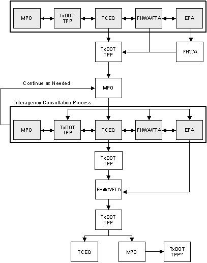
Interagency consultation is key to the transportation conformity process. In the context of the interagency consultation requirements, we were specifically interested in how interagency consultation is working in the application of MOBILE6 and in the development of the SIP motor vehicle emissions budget. This was particularly important at the time of this study because while MOBILE6 is required for regional emissions analysis in conformity, there is no parallel requirement to update motor vehicle emissions budgets with MOBILE6 prior to using MOBILE6 in conformity. Participants discussed interagency consultation as it applies in SIP and motor vehicle emissions budget development and how it applies in conformity.
Six MPOs provided detailed descriptions (Table 2.1) of how the interagency consultation process works in conformity.
| ARC |
As outlined in the Georgia Conformity Interagency Consultation procedure, the ARC is responsible for developing, maintaining, updating and validating the regional travel demand model and data necessary to apply the latest planning assumptions used in the conformity analysis. It is the responsibility of the other interagency partners to provide input on any area of substantive expertise or responsibility (including planning assumptions, modeling, etc.), and provide technical assistance to support the conformity analysis. In practice, all planning assumptions related to the mobile source emissions modeling process are identified and updated/developed in a coordinated effort between ARC and the Environmental Protection Department staff to ensure that, to the extent possible, consistent planning assumptions are used to estimate the motor vehicle emission budgets including in the SIP and total motor vehicle emissions produced by the Regional Transportation Plan. Data is collected from other interagency partners as appropriate to support this work. It is the responsibility of each interagency partner to confer with the other participants in the consultation process, review and comment as appropriate on all proposed and final documents and decisions (to include planning assumptions) in a timely manner. The Interagency group meets monthly, but the process itself is ongoing and is supported by the day-to-day operations and communication between interagency partners during plan development. All planning assumptions related to the mobile source emissions modeling process and conformity analysis are approved by the interagency group prior to ARC Board adoption of the transportation plan and TIP. There must be consensus among the group in order for the process and assumptions to be approved. The ARC website includes an enormous amount of information on the transportation planning and conformity process and can be found at: www.atlreg.com/transportationair/rtptipdownload.html |
|---|---|
| BMC | In Baltimore, a technical workgroup of the Interagency Consultation Group (ICG) staffed by the state departments of transportation and environment and the MPO, developed all MOBILE6 inputs and selected technical methods in estimating emissions. The workgroup's recommendations were reviewed and approved by the full ICG. Subsequently, the full ICG addressed issues related to the use of the model for conformity and the timing of the submitted SIP budgets, which is standard practice for each conformity determination. |
| EWGCC | The EWGCC formed a MOBILE6 workgroup to facilitate the process and agree on all local inputs. |
| MARC | In Kansas City, MARC used an intensive interagency consultation process to address issues related to use of MOBILE5b registration data files, the reliability of default data within MOBILE6, the incorporation of new demographic forecasts, and the creation of new MOBILE6-based mobile source budgets. |
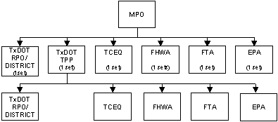
| NCTCOG | Texas has the Technical Working Group (TWG), which consists of representatives from EPA, FHWA, TxDOT, TCEQ and all MPOs in the State. The TWG meets quarterly. A subcommittee from this group took an in-depth look at the transition from MOBILE5 to MOBILE6. Issues that arose were addressed by the subcommittee and then presented to the full group. Having the review agencies there to work out issues proved to be invaluable. The TWG is coordinated by a Steering Committee working closely with staff from the Texas Transportation Institute (TTI). The interagency consultation process in Dallas - Ft.Worth is handled in two separate phases, pre-analysis and post-analysis. Pre analysis is the process in which the NCTCOG obtains concurrence with the consultation partners on analysis parameters (MOBILE, HPMS, TCM, demographics, MVEB's, etc.) prior to the actual analysis being performed to ensure efficiency and avoid duplication of work. Appendix D is the form used to document these analysis parameters. The second phase is the post analysis process, which follows public meetings and local policy body endorsement. The process is estimated to take up to 90 days from submittal of the final analysis through USDOT determination. Appendix E shows all of the 2007 MOBILE6.2 input file parameters for the NCTCOG region. Attachment F summarizes this process. |
| TPB | In Washington, D.C. transportation and air quality staff convened a MOBILE6 Task Force in January 2002 and met approximately monthly through March 2003 to jointly determine each input to the MOBILE6 model. |
All ten of the participating MPOs are in areas where the SIP or maintenance plan has been updated using MOBILE6. In general, the MPOs have not had significant problems revising motor vehicle emissions budgets and having U.S. EPA find the budgets adequate or approved so that they could make conformity determinations using MOBILE6. While there have been some timing issues, the MPOs that have updated budgets reported that they all met the January 2004 deadline for use of MOBILE6. Most of the MPOs credited effective interagency consultation processes as being helpful to coordinating SIP updates and conformity determinations.
We asked the MPOs about MOBILE6 training they had received and whether there are outstanding training or technical assistance needs related to MOBILE6. Eight of the MPOs attended training offered by either FHWA or EPA. The ARC noted that they had extensive experience testing the beta version of MOBILE6 and that their experience with using MOBILE5 was helpful. The following suggestions were provided on potential training needs.
All of the MPOs indicated that technical assistance has been adequate and that FHWA and EPA have been very helpful in responding to questions via email. SEMCOG and HGAC indicated that networking with other MPOs staffs has also been very helpful.
We asked the MPOs whether there were any other issues related to this study that the FHWA and EPA should consider and address. Below is a summary of the responses.
Data Requirements, Collection and Sources
Interagency Issues
Training and Technical Assistance Needs
Overall, the transition to MOBILE6 by the participating MPOs went relatively smoothly. As in many elements of the transportation conformity process, interagency consultation has again proved to be critical to building consensus, making timely decisions on data and assumptions, and discussing technical issues associated with use of the new MOBILE model. In general, training courses have been helpful to all MPOs and the MPOs indicate that technical assistance from EPA and FHWA has helped them make this transition. The MPOs suggestions about additional issues that FHWA and EPA should address will be considered as future research and/or technical assistance needs.
[1] This applies to all States except California, where a State-developed emissions factor model, EMFAC, is used.
[2] For information on EPA's mobile model see: http://www.epa.gov/otaq/m6.htm.
[3]For EPA's Federal Register notice on MOBILE6.2 see: www.epa.gov/fedrgstr/EPA-AIR/2004/May/Day-19/a11340.htm.
[4] www.fhwa.dot.gov/environment/air_quality/conformity/policy_and_guidance/con_guid08.cfm.
[5] Since most of the MPOs have not done truck surveys, privacy issues have not been a concern. However, SEMCOG indicates that when they did a Commercial Vehicle Survey, this was a significant problem as truckers thought this data collection effort was an invasion of privacy. SEMCOG notes that they had a very high turndown rate by truckers in their Commercial Vehicle Survey.
[6] Subsequent to receiving this input from the MPOs, a new evaluation of MOBILE6, MOBILE6.1, and MOBILE6.2 has been completed and can be found at www.nas.edu (NCHRP Project 25-25 Task 7).
Charles Baber
Baltimore Metropolitan Council
Baltimore, MD
cbaber@baltometro.org
Baltimore regional population - 2.5 million
1-hour ozone - severe 15
8-hour ozone - moderate
PM2.5 nonattainment
Mike Clifford
Transportation Policy Board
Washington, D.C.
Mclifford@mwcog.org
Washington, D.C. regional population - 4.5 million
1-hour ozone - severe 15
8-hour ozone - moderate
PM2.5 nonattainment
Tracy Clymer
Atlanta Regional Commission
tclymer@atlantaregional.com
Atlanta regional population - 4.2 million
1-hour ozone - severe 15
8-hour ozone - marginal
PM2.5 nonattainment
Susan E. Hardy
Mountainland Association of Governments
shardy@mountainland.org
Orem, Utah - regional population 308,000
PM-10 nonattainment
CO nonattainment
Candi Nicole Jefferson
East-West Gateway Coordinating Council
Candi.Jefferson@ewgateway.org
St. Louis regional population - 2.5 million
8-hour ozone - moderate
PM2.5 nonattainment
James Joerke
Mid-America Regional Council
jjoerke@marc.org
Kansas City regional population - 1.5 million
1-hour ozone - maintenance
8-hour ozone - unclassifiable
Ross Patronsky
Chicago Area Transportation Study
rpatronsky@catsmpo.com
Chicago regional population - 8.7 million
1-hour ozone - severe 15
8-hour ozone - moderate
SO2 -primary
PM-10 - moderate
PM2.5 nonattainment
Karl Pepple
Houston-Galveston Area Council
Karl.pepple@h-gac.com
Houston regional population - 4.6 million
1-hour ozone - severe 17
8-hour ozone - moderate
Joan Weidner
Southeast Michigan Council of Governments
weidner@semcog.org
Detroit regional population - 4.9 million
8-hour ozone - moderate
PM2.5 nonatttainment
Dawn Dalrymple
North Central Texas Council of Governments
ddalrymple@nctcog.org
Dallas-Ft. Worth regional population - 5 million
1-hour ozone - serious
8-hour ozone - moderate
Name:
MPO Name/Agency filling out this Questionnaire:
Thank you for your assistance!
ARC produces forecasts of population, households by income, employment by industry, and land use by type using a two-step procedure. First a control forecast is produced for the study area, as a whole, using the Interactive Population and Econometric Forecasting (IPEF) model. This control forecast is then disaggregated to individual census tracts using the Disaggregated Residential Allocation Model/Employment Allocation (DRAM/EMPAL) model.
The DRAM/EMPAL model distributes the population and employment in the control forecast to the 589 census tracts that comprise the 13-county study area. It is an iterative model forecasting change over a five-year period. The result of each forecast becomes the base for the next. Important variables affecting the forecast for a given census tract include existing population and employment at the beginning of the forecast period, change in population and employment in the tract over the previous five-year period, the amount of vacant developable land in the census tract and the accessibility of the tract to the rest of the study area. Accessibility is derived using the travel demand model that accounts for existing and planned transportation facilities and congestion levels on those facilities.
ARC invests considerable effort in monitoring local growth trends. Estimates of population, housing and place-of-work employment are produced annually for census tracts in the 10-county ARC planning area and at five-year intervals for the three counties in the study area for these forecasts that are not in the ARC planning area. The DRAM/EMPAL allocation of population and employment serves as the foundation for the travel demand model trip generation and assignment process that calculates VMT across the network.
Vehicle Miles of Travel (VMT) Mix is estimated for freeways, arterials, and collectors for each of the following three areas: Core Urban Counties (Dallas and Tarrant), Core Rural Counties (Collin and Denton), and Perimeter Counties (Ellis, Henderson, Hood, Hunt, Johnson, Kaufman, Parker, and Rockwall). These county groupings were determined by the vehicle activity behavior and demographics of the counties.
The VMT Mix methodology utilizes data, assumptions, and procedure from the Texas Department of Transportation (TxDOT), Texas Transportation Institute (TTI), MOBILE6.2: Mobile Source Emission Factor Model, and The Dallas-Fort Worth TransCAD Regional Travel Model.
Step 1 - Conversion of Federal Highway Administration (FHWA) vehicle classifications into intermediate groups.
The axle-based categories are combined by summation as follows:
| Intermediate Groups | FHWA Vehicle Classifications | ||
|---|---|---|---|
| PV | Passenger Vehicles | C | Passenger |
| P | 2 axle, 4 tire single unit | ||
| Bus | Buses | B | Buses |
| HDV | Heavy-Duty Vehicles | SU2 | 2 axle, 6 tire single unit |
| SU3 | 3 axle, single unit | ||
| SU4 | 4+ axle, single unit | ||
| SE4 | 3 or 4 axle, single trailer | ||
| HDX | Heavy-Duty Diesel Vehicles - Class 8b | SE5 | 5 axle, single trailer |
| SE6 | 6+ axle, single trailer | ||
| SD5 | #5 axle, multi trailer | ||
| SD6 | 6 axle, multi trailer | ||
| SD7 | 7+ axle, multi trailer | ||
Step 2 - Conversion of intermediate categories to MOBILE6 28-vehicle types.
The intermediate categories are disaggregated with appropriate TxDOT registration data, and/or MOBILE6 defaults in multiple steps as illustrated below.
| Intermediate Groups | ||||
|---|---|---|---|---|
| Passenger Vehicle (PV) | Light-Duty Vehicle (LDV) | Light-Duty Gas Vehicle (LDGV)* | ||
| Light-Duty Diesel Vehicle (LDDV)* | ||||
| Light-Duty Truck (LDT) | Light-Duty Truck 1 (LDT1) | LLDT* | LDGT1* | |
| LDGT2* | ||||
| LDDT* | LDDT12* | |||
| LDDT34* | ||||
| Heavy-Light-Duty Truck (HLDT) | LDGT3* | |||
| LDGT4* | ||||
| Buses | Heavy-Duty Diesel Bus - Transit (HDDBT)* | |||
| Heavy-Duty Diesel Bus - School (HDDBS)* | ||||
| Heavy-Duty Gas Bus (HDGB)* | ||||
| Heavy-Duty Vehicle (HDV) | Heavy-Duty Gas Vehicle (HDGV) | HDGV2b | ||
| HDGV3 | ||||
| HDGV4 | ||||
| HDGV5 | ||||
| HDGV6 | ||||
| HDGV7 | ||||
| HDGV8a | ||||
| HDGV8b | ||||
| Heavy-Duty Diesel Vehicle (HDDV) | HDDV2b | |||
| HDDV3 | ||||
| HDDV4 | ||||
| HDDV5 | ||||
| HDDV6 | ||||
| HDDV7 | ||||
| HDDV8a | ||||
| Extra Heavy-Duty Diesel (HDX) | Heavy-Duty Diesel Vehicle - Class 8b (HDDV8b) | |||
Motorcycles are allocated as 0.1 percent for each functional class, subtracted from the Light-Duty Gasoline Vehicles category.
Step 3 - Application of local truck and non-truck data using split identified by the Dallas-Fort Worth TransCAD Regional Travel Model.
The VMT mix calculated above is redistributed utilizing a local truck and non-truck split, for each of the three functional classes and three time periods. This step assumes classification of non-trucks as Motorcycles, LDGV, LDDV, LDGT1 - LDGT4, LDDT12 - LDDT34. All other vehicle classes are considered trucks. Time periods represented are AM peak (6:30 - 9:00), PM peak (3:00 - 6:30), and off-peak.
Step 4 (weekend episode day analysis only) - Adjustment for reduced truck traffic on weekends.
An additional adjustment is applied to weekend (Saturday and Sunday) analyses to account for reduced VMT by trucks. Factors quantified from data documented in the publication FHWA-Rd-98-117, Understanding Traffic Variations by Vehicle Classifications, are applied to the same truck classifications described in Step 3.
Purpose of Analysis
Check Those That Apply and Provide Brief Explanation:
The North Central Texas Council of Governments (NCTCOG) is proposing the following plan and procedures to conduct a transportation conformity analysis. This plan is being submitted to the interagency consultation partners for soliciting consensus before commencement of a full-scale transportation conformity analysis. The plan and procedures may be revised as the NCTCOG proceeds with the analysis. Notification of such changes will be made to the interagency consultation partners. Specifically, the process will consist of a Plan Update as a result of new demographics, updated revenue forecasts, and refinements to Plan recommendations. The TIP will incorporate necessary modifications in its three-year scope. In addition, this analysis will meet the 18-month conformity requirement following submittal of a new SIP to EPA and will utilize MVEB's deemed adequate for transportation air quality conformity purposes.
Metropolitan Transportation Plan/Transportation Improvement Program
Demographics
Population:
NCTCOG will use the latest State government population projections issued by the Department of Economic Development.
Employment:
NCTCOG will use the latest State government employment projections issued by the Department of Economic Development.
Socio-economics:
NCTCOG will use the latest Socio-economic data published in a report entitled "The Socio-economic Factors for the Urbanized Planning Area", January 2000.
Validation year: 1999
TIP years: 2002 - 2004
MTP year: 2025
Conformity Analysis Years
Affected Nonattainment Counties: Collin, Dallas, Denton, Tarrant
Land-Use Model: NCTCOG is currently using the DRAM/EMPAL model.
Travel Demand Model: The VMT will be forecasted by using the Dallas-Fort Worth Regional Travel Model (DFWRTM).
Modal Split/Mode Choice: The modal split for transit ridership will be accomplished through the travel demand model.
VMT Adjustments: NCTCOG will adjust the forecasted VMT to TxDOT's HPMS for all roadway facilities based on a 1.28 DFWRTM validation error.
State Implementation Plan
The Attainment Demonstration State Implementation Plan for 2007 is the applicable SIP. The SIP motor vehicle emissions budgets deemed adequate by the Environmental Protection Agency are:
Control Strategies
Emission reduction credits will be taken for the following on-road mobile SIP commitments.
| Strategy | Methodology | |
|---|---|---|
| a | Speed Limit Reduction (5mph) | DFWRTM |
| b | Transportation Control Measures | See MERS list below |
| c | Voluntary Mobile Emission Reduction Measures | See MERS list below |
| d | Remote Sensing | Post processed (ERG) |
| e | I/M Programs | MOBILE |
| f | Tier 2/Low Sulfur | EPA guidance (TTI methodology) |
| g | Heavy Duty Gasoline Vehicle Rule | MOBILE |
| h | California Diesel Fuel | Post processed (ERG) |
Mobile Source Emission Reduction Strategies
NCTCOG will take emissions credits for the following Transportation Control Strategies. Emission benefits will be modeled directly in the DFWRTM, or a documented post-process methodology will be used.
| Strategy | Category | Modeled | Post-processed | Year(s) Credited | |
|---|---|---|---|---|---|
| a. | Intersection Improvements | TCM | x | 07, 15, 25 | |
| b. | Rail Service | TCM | x | 07, 15, 25 | |
| c. | High Occupancy Vehicle Lanes | TCM | x | 07, 15, 25 | |
| d. | Park-n-Ride Lots | TCM | x | x | 07, 15, 25 |
| e. | Vanpools | TCM | x | 07, 15, 25 | |
| f. | Grade Separations | TCM | x | 07, 15, 25 | |
| g. | Traffic Signal Improvements | TERM | x | 7 | |
| h. | Intelligent Transportation Systems | TERM | x | 07, 15, 25 | |
| i. | Clean Vehicle Commitments | VMEP | x | 7 | |
| j. | Bicycle/Pedestrian Facilities | TCM | x | 07, 15, 25 | |
| k. | Employer Trip Reduction Programs | VMEP | x | 07, 15, 25 | |
| l. | Vehicle Retirement Program | VMEP | x | 07, 15, 25 | |
| m. | Sustainable Development | VMEP | x | 7 | |
| n. | Public Education/ Ozone Season Fare Reduction | VMEP | x | 07, 15, 25 |
MOBILE Model
NCTCOG will use the following MOBILE model input parameters in the conformity analysis.
| Parameter | Details | Data Source | |
|---|---|---|---|
| a. | Emission Model Version(s): | MOBILE5ah, MOBILE5b | EPA |
| b. | Emission Model Runs: | Years 2007, 2015, and 2025 | |
| c. | Time Periods: | 11 time periods and a 24-hour analysis | NCTCOG |
| d. | Pollutants Reported: | VOC, NOx, CO | |
| e. | Calendar Dates: | 1-Jul | |
| f. | Vehicle Class: | EPA 8 classification | EPA |
| g. | Functional Class: | ||
| h. | Temperatures: | Min., Max., Ambient; for each time period/county | TCEQ |
| i. | VMT mix: | Local data calculated from EPA default | NCTCOG |
| j. | Speed: | 1-65 mph | |
| k. | Vehicle Registration: | Year 1999 | TxDOT |
| l. | I/M Program: | ASM/OBDII | |
| m. | RVP: | 7.1 | |
| n. | Low Sulfur Diesel: | 15 ppm | |
| o. | Local Area Parameters: | ||
| p. | Strategies: | RFG, NLEV, Tier2, HDDV | |
| q. | Meteorological data: | Not included in MOBILE5 (Cloud cover, humidity, sunrise/sunset) | TCEQ |
Project Listings
A roadway listing, including all projects that change roadway capacity (new roads, widenings, roadway removals, etc.) will be provided in addition to the following:
CMAQ Projects
NCTCOG will include a spreadsheet in the conformity document showing status of funded CMAQ projects, including; emission reductions for each project, amount of funding for each project, and implementation dates.
Non-Federal Projects
NCTCOG will identify all projects in the MTP and TIP that do not receive federal funding (local initiatives, private ventures, etc.).
Exempt Projects
NCTCOG will identify exempt projects in the TIP according to the specifications outlined in the Conformity Regulations (§93.126).
| Command | Input Parameter Values | Description |
|---|---|---|
| Calendar Year | 2007 | Attainment Year; Required |
| Evaluation Month | 7 | July, representing summer ozone season |
| Minimum/Maximum Temperature | N/A | See Hourly Temperatures |
| Hourly Temperatures | See 99temperature.txt | County-specific 1999 episode temperatures, provided by TCEQ |
| Altitude | 1 | Low altitude; EPA default |
| Relative Humidity | See 99humidity.txt | County-specific 1999 episode humidity, provided by TCEQ |
| Barometric Pressure | See 99pressure.txt | County-specific 1999 episode pressure, provided by TCEQ |
| Environmental Effects on Air Conditioning: Commands used by MOBILE6 to model the extent of vehicle air-conditioning usage. | ||
| CLOUD COVER | 0% | EPA default |
| PEAK SUN | 10 A.M./4 P.M. | EPA default |
| SUNRISE/SUNSET | 7 A.M./8row P.M. | Regionally-specific 1999 episode data, provided by TCEQ |
| Command | Input Parameter Values | Description |
|---|---|---|
| Registration Distribution | See external files: reg03.* | County specific July 2003 LDV data and area specific July 2003 HDV data from TxDOT. LDVs in Collin, Dallas, Denton, and Tarrant Counties are weighted by County-to-County Worker Flow data from the 2000 census. |
| Diesel Fractions | See 03 diesel fractions.txt | 2003 EPA defaults applied for light-duty categories and HDBS. Area specific 2003 TxDOT registration data used for HDV classes. |
| Mileage Accumulation Rates | See technical report: M6FLT.007 | EPA default; annual mileage accumulation rates by vehicle type and age. |
| Natural Gas Vehicle (NGV) Fraction | 0 | EPA default. |
| NGV Emission Factors | None | EPA default; alternate NGV emissions factors for each of the 28 vehicle types, for running and start emissions. |
| Command | Input Parameter Values | Description |
|---|---|---|
| Vehicle Miles of Travel (VMT) Fractions | N/A | POST-PROCESSED. VMT mix fractions are applied to link VMT using IMPSUM6 utility from TTI; see Section II-5.2 for more information. |
| VMT By Facility | See technical report: M6.SPD.003 | EPA default; VMT fractions by MOBILE6 road types are used to combine the four individual road type emissions factors into the "all road types" emissions factors. Data has no impact for this analysis. |
| VMT By Hour | See external files: hrvmt_*.* | Regionally specific, derived from 2002 ATR data. Specific data sets for Monday, midweek (Tues-Thursday), Friday, Saturday, and Sunday. |
| Speed VMT | N/A | Generated by POLFAC62 utility; No input required. |
| Average Speed | N/A | Allows a single average speed for combined freeways and arterials for the entire day. |
| Starts Per Day | See technical report: M6.FLT.003 | EPA default; Specifies average number of engine starts per vehicle per day by vehicle types for weekend days and weekdays. |
| Start Distribution | See technical report: M6.FLT.003 | EPA default; allocates engine starts by hour of the day for weekend days and weekdays. |
| Soak Distribution | See technical reports: M6.FLT.003 and M6.FLT.004 | EPA default; alternate vehicle soak duration distributions for weekend days and weekdays. |
| Hot Soak Activity | See technical reports: M6.FLT.003 and M6.FLT.004 | EPA default; specifies a hot soak duration distribution for each of 14 daily time periods for weekend days and weekdays. |
| Diurnal Soak Activity | See technical report: M6.FLT.006 | EPA default; identifies diurnal soak time distributions for each of 18 daily time periods. |
| Week Day Trip Length Distribution | See external files: 07wdtrip.* | Regional data derived from the TransCAD Regional Travel Model, distributions applied for AM peak (6:00-9:00), PM peak (15:00-19:00), and Off-peak. |
| Weekend Trip Length Distribution | Same values as Week Day Trip Length Distribution | Regional data derived from the TransCAD Regional Travel Model, distributions applied for AM peak (6:00-9:00), PM peak (15:00-19:00), and Off-peak. |
| Weekend Vehicle Usage | Flag Activated; No input required | Directs MOBILE6 to use weekend activity data for calculating emissions factors. Parameter applied to episode days August 14, 15, 21, and 22, for all counties. |
MOBILE6 STATE PROGRAMS
Note: Inspection and Maintenance (I/M) Programs and associated Anti-Tampering Programs (ATP) are modeled in a multi-step format to appropriately account for mid-year start dates and varied requirements for particular model year vehicles. Modeling an ATP for analysis year 2007 requires three MOBILE6 input files for each I/M Program.
For Dallas and Tarrant Counties: one input file (a) models ATP for 1983 model year vehicles. The second file (b) models ATP for post-1983 vehicles. The third file (c) models no ATP. These files are combined as follows:
Emission Factor (EF)final=EFATP(a) + EFATP(b) - EFATP(c)
For Collin, Denton, Ellis, Johnson, Kaufman, Parker, and Rockwall Counties, the above process is utilized in combination with a second multi-step input file equation to account for the mid-year start of the I/M Program. Emission factors from input files a, b, and c, plus a second set (x, y, and z) are calculated as indicated above, then adjusted and combined to account for multiple ATP and mid-year start I/M programs. The basic equations are as follows:
Emission Factor (EF)final=(adj1)(EFabc)+ (adj2)(EFxyz)
where,
EFabc=EFATP(a) + EFATP(b) - EFATP(c)
EFxyz=EFATP(x) + EFATP(y) - EFATP(z)
adj1=((N-1)12 + 8)/12N
adj2=4/12N
N=analysis year (2007)
See section II-5 for more information.
| Input Parameter Values | Description | |
|---|---|---|
| Stage II Refueling | N/A | Accounted for as an area source category. Allows modeling of at-the-pump refueling emissions. |
| counties | start year | model years | subject vehicles | test only 1=no 2=yes | frequency 1=annual 2=biennial | compliance rate | checks performed | |
|---|---|---|---|---|---|---|---|---|
| Dallas/Tarrant (a) | 86 | 83 | 83 | 22222 22222222 2 | 1 | 1 | 096. | 21112222 |
| Dallas/Tarrant (b) | 86 | 84 | 05 | 22222 22222222 2 | 1 | 1 | 096. | 22112222 |
| Collin/Denton (a) | 02 | 83 | 83 | 22222 22222222 2 | 1 | 1 | 096. | 21112222 |
| Collin/Denton (b) | 02 | 84 | 05 | 22222 22222222 2 | 1 | 1 | 096. | 22112222 |
| Collin/Denton (x) | 03 | 83 | 83 | 22222 22222222 2 | 1 | 1 | 096. | 21112222 |
| Collin/Denton (y) | 03 | 84 | 05 | 22222 22222222 2 | 1 | 1 | 096. | 22112222 |
| Ellis, Johnson, Kaufman, Parker, and Rockwall (a) | 03 | 83 | 83 | 22222 22222222 2 | 1 | 1 | 096. | 21112222 |
| Ellis, Johnson, Kaufman, Parker, and Rockwall (b) | 03 | 84 | 05 | 22222 22222222 2 | 1 | 1 | 096. | 22112222 |
| Ellis, Johnson, Kaufman, Parker, and Rockwall (x) | 04 | 83 | 83 | 22222 22222222 2 | 1 | 1 | 096. | 21112222 |
| Ellis, Johnson, Kaufman, Parker, and Rockwall (y) | 04 | 84 | 05 | 22222 22222222 2 | 1 | 1 | 096. | 22112222 |
Inspection & Maintenance (I/M) Commands: No I/M program modeled in Hood, Henderson, and Hunt Counties in 2007.
Collin, Dallas, Denton, Ellis, Johnson, Kaufman, Parker, Tarrant, and Rockwall I/M data provided by Eastern Research Group.
Note: Multiple I/M external files are required to correctly model the mid year start date I/M program as discussed above. The values presented below represent the I/M programs with their actual start date. This data is modeled with files a, b, and c. To model the second set of files: x, y, and z, adjustments are made to the start year for Collin, Denton, Ellis, Johnson, Kaufman, Parker, and Rockwall for I/M Programs 1, 2, and 3.
| I/M Program | 1 | 2 | 3 | 4 | 5 | 6 | Identifies program number when multiple programs are modeled |
|---|---|---|---|---|---|---|---|
| start year | 1990 | 1990 | 1990 | 1996 | 1996 | 1996 | Dallas and Tarrant Counties |
| 2002 | 2002 | 2002 | 2000 | 2000 | 2000 | Collin and Denton Counties | |
| 2003 | 2003 | 2003 | 2000 | 2000 | 2000 | Ellis, Johnson, Kaufman, Parker, and Rockwall Counties | |
| end year | 2050 | 2050 | 2050 | 2050 | 2050 | 2050 | Program specifications |
| frequency | 1 | 1 | 1 | 1 | 1 | 1 | Annual testing; program specifications |
| type | TRC | TRC | TRC | TRC | TRC | TRC | Computerized test and repair |
| name | 2500/ IDLE | ASM 2525/5015 PHASE-IN | OBD IM | GC | GC | EVAP OBD & GC | Exhaust and evaporative; program specifications |
| I/M Model Years | 1983 2005 | 1983 1995 | 1996 2005 | 1983 2005 | 1983 1995 | 1996 2005 | Program definition; 24 year rolling window, 2-year new car exemption |
| I/M Vehicles | 11111 22222222 2 | 22222 11111 111 1 | 22222 11111111 1 | 11111 22222222 2 | 22222 11111111 1 | 22222 11111 111 1 | All gasoline vehicles tested |
| I/M Stringency | 20. | 20. | 20. | N/A | N/A | N/A | Exhaust program only: failure rate for pre 1981 model year vehicles (%) |
| I/M Compliance | 96. | Expected compliance (%) | |||||
| I/M Waiver Rates | 3 3 | % waiver rate for pre 1981 vehicles and 1981 and later model year vehicles. | |||||
| I/M Exemption Age | 25 | EPA default; age at which a vehicle is no longer subject to mandatory I/M requirements | |||||
| I/M Grace Period | 2 | Program definition; age at which a vehicle is first subject to mandatory I/M requirements | |||||
| I/M Effectiveness | 1.0 1.0 1.0 | Applies only to exhaust program; optional | |||||
| I/M Cutpoints | N/A | Optional for exhaust (but required for IM240). Do not use with evaporative. | |||||
| No I/M Technical Training Course (TTC) Credits | N/A | Optional for exhaust. Do not use with evaporative. | |||||
| I/M Descriptive File | N/A | Optional for both exhaust and evaporative. | |||||
| Command | Input Parameter Values | Description | |
|---|---|---|---|
| Core Counties | Perimeter Counties | ||
| Gasoline Sulfur | 234.0 ppm | 304.3 ppm | see Technical Description of the Toxics Module for MOBILE6.2 and Guidance on Its Use for Emissions Inventory Preparation, Nov 2002, EPA420-R-02-029. Data provided by Eastern Research Group and Texas Commission on Environmental Quality. |
| Fuel Reid Vapor Pressure (RVP) | 6.8 psi | 7.6 psi | See Technical Description of the Toxics Module for MOBILE6.2 and Guidance on Its Use for Emissions Inventory Preparation, Nov 2002, EPA420-R-02-029. Data provided by Eastern Research Group and Texas Commission on Environmental Quality. |
| Fuel Program | 2 S | 1 S | Core Counties: Reformulated Gasoline (RFG) for southern region; Perimeter Counties: Conventional Gasoline East |
| Oxygenated Fuels | N/A | Models effects of oxygenated gasoline on exhaust emissions for all gasoline-fueled vehicle types. | |
| Season | 1 | EPA default; summer | |
| Command | Input Parameter Values | Description |
|---|---|---|
| No Clean Air Act | N/A | Models vehicle emissions as if the Federal Clean Air Act Amendments of 1990 had not been implemented. |
| HDDV NOx Off-Cycle Emissions Effects: | ||
| No Defeat Device | N/A | |
| No NOx Pull Ahead | N/A | |
| No Rebuild | N/A | |
| Rebuild Effects | 90% | Provided by TCEQ |
| Tier 2 Emission Standards and Fuel Requirements: Overrides default Tier 2 emissions standards and fuel requirements settings. | ||
| No Tier2 | N/A | |
| Tier2 Exhaust Phase-in | N/A | |
| Tier2 Evaporative Phase-in | N/A | |
| Tier2 Certification | N/A | |
| 94+ LDG Implementation | N/A | Applies alternate 1994 and later fleet penetration fractions for LDGVs under the Tier 1, NLEV (or California LEV 1), and Tier 2 emissions standard programs. |
| No 2007 HDDV Rule | N/A | Disables 2007 Heavy Duty Diesel Vehicle emissions standards. |
 |
|
||||||||||||||||||
Interagency Consultation Process
Note: These steps continue until all partners are satisfied their comments have been adequately addressed. * Informational copy to all parties. |
|||||||||||||||||||
| Revised 8/2/04 | |||||||||||||||||||