

| << Previous | Contents | Next >> |
Relationships Between Asset Management and Travel Demand:
Findings and Recommendations from Four State DOT Site Visits
Chapter 4. Assessment of Four State DOTs' Use of Asset Management To Address Travel Demand Growth
4.1 Approach
This chapter provides a detailed review of how the four state DOTs participating in this study are currently utilizing TAM practices to address issues relating to existing and anticipated future growth in travel demand. The review is based on data collected during two- to three-day site visits at the DOT headquarters of each state between March and June 2006. The interview guide used during these on-site visits is reproduced in Appendix A. Subsequent appendices provide state DOT responses to a survey completed prior to each site visit.
The chapter describes the following, organized by state according to the order in which the interviews were conducted:
- Organizational structure of the state DOT
- Major components of TAM programs
- Travel demand measurement and forecasting capabilities
- Links between TAM and travel demand measures
Following are brief descriptions of the understanding sought for each of these characteristics.
4.1.1 Organizational Structure of the State DOT
Reviews of state DOT organization charts provided a basic understanding of the roles, responsibilities, and structure of each participant agency. These reviews also helped to identify those agency divisions with asset management, travel demand measurement, or travel demand forecasting responsibilities and the interrelationships among these and other divisions that consume TAM and/or travel demand data. These reviews were also helpful in identifying each DOT's relationships with those outside bodies that provide decision-making authority for large transportation investments (e.g., the Transportation Board or Commission).
4.1.2 Major Components of TAM Programs
In exploring the links between TAM and travel demand, this study employs the American Association of State Highway and Transportation Officials' (AASHTO's) current definition of TAM, as established at the January 2006 meeting of AASHTO's Subcommittee on Asset Management:
Transportation Asset Management is a strategic and systematic process of operating, maintaining, upgrading, and expanding physical assets effectively through their life cycle. It focuses on business and engineering practices for resource allocation and utilization, with the objective of better decision-making based upon quality information and well-defined objectives.
The interview and analysis process study was designed to document each of the primary asset management techniques and processes as encompassed by this broad definition. These include the following:
TAM program focus
The relative strengths, weaknesses, and primary focus of each state DOT's TAM program reflects its historical development as well as the particular needs, legislative environment, funding capacity, and "color-of-money" limitations within each state. Given these considerations, a key objective of this study was to determine the primary focus and priorities of each state's existing asset management program. The assessment below demonstrates that many TAM programs remain focused on traditional asset management practices (e.g., pavement and bridge management) with a heavy emphasis on system preservation. It also shows that, at this time, most TAM programs make only modest use of travel demand measures for the following two reasons:
- Agencies have not developed models that incorporate infrastructure utilization (e.g., VMTs) in their preservation needs analyses.
- Current TAM programs are preservation focused while travel demand growth issues are typically best addressed by capacity expansion and operational improvement investments.
Goals, objectives, and performance measures
Goals, objectives, and performance measures provide transportation agencies with strategic direction and ongoing performance evaluation. The specific goals and objectives selected either for the DOT as a whole (broad) or for the TAM program in particular (more narrow) typically reflect the agency's primary concerns and those issues of highest priority. A review of these goals and objectives can quickly reveal the relative importance placed on travel demand-related issues (e.g., mobility and congestion) within the broader scope of issues facing each DOT. As shown below, travel demand issues are not typically addressed by the state's TAM program goals, but are typically considered in the broader, agency-wide goals.
"Baseline" asset management tools
Most state DOTs have implemented basic asset management practices in the form of "traditional" pavement, bridge, and maintenance management systems. Documentation of the existence and use of these traditional systems provides a crude baseline measure of the maturity of each state's TAM program.
Data collection and distribution
The collection and dissemination of quality asset management and travel demand data remains a cornerstone of effective asset management. Stated differently, effective decision-making relies on quality information which, in turn, relies on the availability of high-quality data. Moreover, the inclusion of travel demand measures in asset management analyses requires links between those databases housing the appropriate asset management data (e.g., asset inventory and physical condition) and those housing the corresponding travel demand measures (e.g., vehicle counts and VMT forecasts) for the same network segments. This review considers what asset management data the agencies are collecting (including travel demand data) and how these data are made available to potential users within the state DOT.
The most commonly collected data are infrastructure inventories for pavement, bridges, tunnels, vehicles, and real estate; asset age, condition, maintenance history, and related data; projections of future asset conditions using forecasting tools; current travel demands as measured by traffic counts; and future travel demands creating using forecasting tools. These data are required to support each state's pavement, bridge, and maintenance management systems; travel demand models; and other management systems for assets. Using some or all of these data, DOTs can evaluate current asset conditions, forecast future conditions, evaluate combinations of fixes, and determine short- and long-term investment needs related to preservation, safety, operations, and capacity.
Investment decision making processes and decision-support tools
All states use some form of internal investment decision-making process to allocate funds to specific projects and programs. In some cases, these processes are supported by the objective analyses of decision-support tools. More often these processes are driven by the independent evaluations of field engineers, the legislative requirements of state and federal funding programs (i.e., the "color of money"), and political processes. Key objectives for this study were to: (1) document how decisions for preservation and capacity improvement investments are currently made within each state, and (2) determine what role, if any, travel demand plays in these decisions.
4.1.3 Travel Demand Measurement and Forecasting Capabilities
Current measures of travel demand
The potential use of travel demand measures within system preservation and expansion investment analyses is ultimately determined by the types of travel demand data collected (e.g., traffic counts, truck counts, travel time delays, and commodity flows), the comprehensiveness of this data (e.g., what portions of the network travel demand are available), and the frequency with which this data is reported (e.g., annually, biennially). Moreover, current travel demand data are prerequisites to the development of regional and statewide travel demand and truck forecasting models. This review documents the types of travel demand data collected by each participant state.
Travel demand forecasting
Reliable travel demand models are prerequisites to the accurate assessment of each state's long-term capacity improvement needs. Specifically, this information is required to answer questions such as: where are the corridors with the highest travel demand growth; where will congestion result in the most significant travel delay costs; where should investment be concentrated to best support the state's economic growth? In addition, travel demand modeling capability is also a critical input for benefit-cost analyses of major transportation investment projects and their alternatives. This review documents the auto and truck travel demand forecasting capabilities of each participant state.
4.1.4 Links Between TAM and Travel Demand Measures
As outlined in Chapter 3, the primary objective of these interviews was to identify and document all cases in which state DOTs have incorporated travel demand measures within the TAM process. Potential links between TAM and travel demand include the following:
Current and projected travel demand measures as inputs to the TAM process
- Infrastructure deterioration rates (e.g., roadway wear)
- Investment prioritization
- Project benefit-cost and alternatives analysis
Using the TAM process to address issues related to travel demand and transportation planning
- Capacity improvements
- Safety improvements
- Investment tradeoffs between preservation and capacity needs
- Objectives and performance measures
FHWA's Office of Asset Management and Office of Planning have teamed recently to provide guidance to state DOTs, MPOs, and other agencies responsible for transportation planning. Planners and MPOs "must balance funding realities with mobility needs," much in the same way that asset managers must balance funding realities with preservation needs. Because long-range planning typically lies within the realm of transportation planning, long-range planning and budgeting were not well-defined within each state's current asset management program, but were addressed in SLRPs. For this reason, consideration of these topics is discussed in greater detail in the next chapter, which details the contents and priorities of each state's current SLRP.
4.2 Michigan DOT (MDOT)
4.2.1 Organizational Structure of the State DOT
In Michigan, ownership of public highways and related infrastructure is distributed among MDOT and 616 other organizations, primarily counties and municipalities. In 1998, the state legislature established an Asset Management Council, independent of MDOT, and adopted asset management as the "way of doing business" for all of these organizations. The purpose of the Council is to recommend processes for developing and implementing asset management principles.
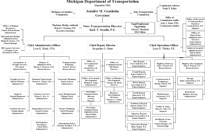
The most prominent organization in Michigan responsible for stewardship of highways is MDOT. Like counties and municipalities, MDOT reports to the Council and has undertaken a number of activities related to asset management. Within MDOT, for example, the Bureau of Planning's Asset Management Division at this time is largely responsible for collecting, analyzing, and providing data such as an infrastructure inventory, current infrastructure conditions, and future projected conditions to internal customers. Other divisions within the Bureau of Planning include the Statewide Planning, Intermodal Planning, and Project Planning divisions. These divisions also collect, analyze, and provide data. Statewide Planning, for example, is responsible for providing technical assistance to the various MPOs in Michigan and for developing a statewide transportation model. Exhibit 4-1 presents MDOT's organizational structure.
Data from the Planning Bureau becomes an important part of the project development and decision-making processes, which occur largely in decentralized fashion within MDOT's seven regions. Regional leaders produce prioritized lists of projects for rehabilitation and reconstruction of their infrastructure, which ultimately, through a resource negotiation process, are constrained and selected based on a variety of technical and non-technical criteria.
In Michigan, the legislature is the "champion" for asset management, which is carried out by the Asset Management Council statewide and by the Asset Management Division and other related divisions within the Planning Bureau at MDOT.
Exhibit 4-1: MDOT's organizational structure (Description)
Full-size PDF
4.2.2 Major Components of TAM Program
MDOT maintains one of the nation's most mature asset management programs. The following are descriptions of the key components of MDOT's existing asset management program.
Asset management as a "way of doing business"
Asset management in Michigan became a "way of doing business" when the state legislature mandated the use of TAM practices in 1998. Since then, MDOT has reorganized itself around this legislative requirement and focused on developing tools and processes that support responsible stewardship of existing transportation infrastructure in the state. This realignment of business processes has fostered development of a comprehensive approach to asset management across the state and has ensured broad support of asset management activities within MDOT.
Statewide process
The concept of asset management extends beyond MDOT and includes transportation agencies at all levels within the state, coordinated through the Asset Management Council. In support of this broad application of asset management, MDOT maintains a regular liaison with members of the Asset Management Council. This line of communication serves to promote coordination of investment activities across the state as well as provide a forum for sharing new asset management objectives and approaches. MDOT, the focus of this study, is only responsible for roughly 10 percent of all state centerline highway miles (about 10,000 centerline highway miles across the state); hence, ongoing communication and coordination between MDOT and the Asset Management Council ensures that a much broader share of the state's roadway infrastructure is encompassed within an asset management program.
Focus on preservation
As is the case for each of the states participating in this study, MDOT's asset management program is primarily focused on the maintenance and preservation of Michigan's state-maintained highways and related facilities. Within each state, this focus reflects the high cost of maintaining and preserving a large inventory of aging highway assets. Moreover, state legislation requires that 90 percent of all state transportation funds be committed to maintenance- and preservation-related activities. As a result of this policy, the availability of funds for new capacity-related projects is extremely limited. This situation focuses the current asset management program on the issue of preservation and significantly constrains the state's ability to address long-term travel demand- and performance-related issues experienced in the state's urban areas.
Goals, objectives and performance measures
The goals and objectives of MDOT's Asset Management Division fully reflect the focus on preservation, but do not currently emphasize travel demand-related issues. Specifically, the Asset Management Division has adopted these specific objectives:
- Maintain 95 percent of freeway and 85 percent of non-freeway state-owned pavements in "good" condition by 2008
- Maintain 95 percent of freeway bridges and 85 percent of non-freeway bridges in "good" condition by 2008.
In addition to these TAM program goals, MDOT has also adopted agency-wide strategic goals including preservation, safety, basic mobility, strengthening the state's economy, transportation service coordination, intermodalism, environment and aesthetics, and land use coordination. Chapter 5 addresses these strategic goals in more detail.
"Baseline" asset management tools
As with the other study state DOTs, MDOT employs pavement management, bridge management, and maintenance management systems. Each of these systems is supported by detailed asset inventories of the state's roadway segments, bridges, signs, guardrails, and other assets. MDOT staff are currently working to develop systems to inventory and analyze the investment needs of all ancillary infrastructure components not currently included within the state's existing management systems (e.g., pump stations and roadside rest areas). The ultimate goal is to ensure comprehensive coverage of all asset types.
Data collection and distribution
MDOT's Asset Management Division acts in many respects as an information repository. Its key mission is to manage and distribute high-quality data to all potential customers, both inside and outside of state government. These data include infrastructure inventories, infrastructure conditions, and current and forecast utilization (e.g., traffic volumes). Data management involves numerous stakeholders, from the personnel that collect data (data are collected by staff throughout MDOT), to the independent state agency that houses data, to the various internal and external customers that use data to improve their decision-making capabilities.
The data maintained by the Asset Management Division are housed in the Transportation Management System (TMS) database, which includes a basic inventory of highway assets and six additional components, including the following:
- Bridge Management System (BMS): This system includes bridge inventory, inspection, and work history data collected by staff in the Construction and Technology Division.
- Intermodal Management System (IMS): This system includes asset inventory for non-highway assets such as airports, border crossings, carpool lots, ferry services, and rail collected by a variety of specialists across MDOT coordinated by the Bureau of Transportation Planning.
- Pavement Management System (PMS): Sufficiency rating of highway segments based on an annual windshield survey that has been conducted since 1961. Staff from the Construction and Technology Division rate each segment on a subjective scale of 1 through 5. In addition, the PMS includes a rating, based on the more detailed pavement data collected biannually, that is used to determine the remaining service life (RSL) for each section of pavement.
- Safety Management System (SMS): MDOT's SMS includes crash records, road segment and right-of-way data, and intersection and interchange data, which allow users to summarize information of interest related to crashes and crash locations. the Traffic and Safety Division collects and maintains SMS data.
- Congestion Management System (CMS): The CMS tracks current measures of travel demand through annual traffic counts along the Michigan trunkline highway system. The contents of this database are described below under "current measures of travel demand."
- Public Transportation Management System (PTMS): PTMS includes a statewide vehicle inventory used for forecasting needs and a financial database for budgeting collected and maintained by the Division of Passenger Transportation, within the Bureau of Urban and Public Transportation.
In addition to the TMS, MDOT produces an annual Sufficiency Report, which contains detailed profiles of each segment of the state's trunkline highways. This includes the segment's geographic location, geometry, highway classification, number of lanes, AADT, estimated truck AADT, speed limit, pavement conditions, work history, capacity, travel forecast data, and other data. The majority of these data are also available through the TMS, which is part of the overall MAP database, a centralized statewide repository of data accessible by all DOT staff. Of particular convenience is the ability to key off of a geo-coded highway inventory when searching for data and information about roadway conditions and utilization. Effectively, between TMS, the Sufficiency Report, and linkages to the MAP database, the Asset Management Division is a "one-stop shop" for all data and information, including data and information related to travel demand, for state-owned infrastructure.
System preservation processes and decision-support tools
In Michigan, rehabilitation and reconstruction (preservation) projects are selected and prioritized at the regional level according to a detailed process that is uniform across all districts. These projects are then evaluated at the statewide level using the software program MAPSCORE, developed internally, which relies on a variety of measures to score the relative merits of various proposed and programmed projects, some of which include travel demand. These measures are:
- Remaining service life (15 percent)
- Road quality index (15 percent)
- Safety score (5 percent)
- District priority (25 percent)
- Cost per VMT per year (10 percent)
- Cost per lane-mile per year (10 percent)
- Return on investment (10 percent)
- Maintenance savings (10 percent)
| MDOT's Road Quality Forecasting System (RQFS) | |||||||||||||||||||||
|---|---|---|---|---|---|---|---|---|---|---|---|---|---|---|---|---|---|---|---|---|---|
|
QFS is a forecasting tool that predicts future performance of a pavement network under a variety of investment scenarios, allowing users to compare the relative merits of various strategic alternatives. RQFS inputs include the following:
Alternative strategies are developed based on the available resources and typically include a mix of fixes. Although RQFS does not select projects, users can identify the most cost-effective overall network strategy, then identify specific projects to achieve that strategy. |
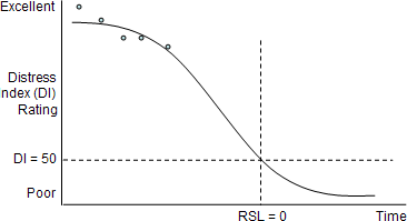
Some of the above measures are obtained using Michigan's Road Quality Forecasting System (RQFS), a pavement management tool that draws on current pavement age, condition data, and investment strategies to forecast future conditions. For example, Exhibit 4-2 provides a sample RQFS output based on a hypothetical investment scenario. The exhibit shows current and future RSL. The tool is also used to identify a cost-effective "mix of fixes" for pavement preservation. MDOT also maintains a similar program, the Bridge Quality Forecasting System (BQFS), for prioritizing bridge projects.
Over time, MDOT staff have continued to improve and refine their TAM capabilities and tools such that today, the staff's recommendations for system preservation activities are generally accepted by the state Transportation Commission, although the Commission may still exercise its discretion to alter resource allocation commitments. The analytical rigor of the state DOT's recommendations include the following:
- Decentralized development of lists of prioritized projects at the regional level, each following a uniform, highly-detailed prioritization process
- Usage of uniform, statewide data that feed the selection of projects at all levels
- Usage of the MAPSCORE project evaluation process, which compares projects across districts, and lends credibility to the estimation of future needs
Exhibit 4-2: Example RQFS output based on a hypothetical investment scenario (Description)
Capacity improvement decision processes
Capacity-related projects in Michigan are prioritized by the Project Planning Division at the statewide level. Each proposed project undergoes an evaluation that is objective "to the extent possible." Analysts take a benefit-cost approach that draws on existing sources of data from the CMS and other sources to produce a score for each proposed project.
As noted above, Michigan law stipulates that 90 percent of all state transportation funds be devoted to preservation. Of the remaining 10 percent available for system expansion and other uses, most are dedicated to Congressionally-earmarked projects. As a result, the state Transportation Commission has not recently exercised its authority to decide allocation of resources to capacity-related projects.
| MDOT's MAPSCORE |
|---|
|
MAPSCORE is a decision-support software tool used by MDOT staff to provide input to professionals regarding the relative merits of various transportation projects. Since MDOT relies on its regional offices to a large extent for identification and prioritization of projects, MAPSCORE provides staff with an objective tool for verifying regional input and for providing feedback on the project prioritization process. MAPSCORE uses a variety of input measures to produce a single evaluative measure for each project. Input measures include the following, each converted to a value ranging from 1-100 and weighted according to the percentages indicated:
|
4.2.3 Travel Demand Measurement and Forecasting Capabilities
Current measures of travel demand
Michigan tracks current measures of travel demand through annual traffic counts along its trunkline highway system. As noted above, these counts are maintained in the TMS. Specifically, these data include raw vehicle counts, classifications by vehicle type (e.g., small and large truck counts), intersection counts, speeds, travel time delays, and special studies.
Travel demand forecasting
MDOT currently produces a statewide travel demand model and, like many states, is in the process of refining and improving the model's capabilities and uses. In addition, there are 12 MPOs in Michigan, each of which produces its own regional travel demand forecasts (7 of which are maintained by MDOT staff on behalf of some of the state's smaller MPOs). Input data for the statewide model include the MPO models themselves, traffic counts from the primary highway network, and projected growth rates in population. Model outputs include projected traffic flows, estimated travel speeds, travel paths, commodity flows, and VMTs. The travel demand model is used to estimate future congestion (i.e., volume-to-capacity ratios), VMT, level of service (LOS), and future highway user-tax revenues. In addition, the output data are co-located with other data (e.g., location, roadside features, and pavement condition of highway segments or links) and are accessible by all internal DOT customers for their own independent analyses. MDOT also has a truck model used to analyze current and project future truck movements throughout the state. The Transportation Planning Division uses these data as inputs for validation of the statewide travel demand model. Like many state DOTs, MDOT is in the process of refining and improving the model's capabilities and uses. Although not all aspects and data that compose the modeling process are captured specifically in the CMS, all model outputs are made available through the TMS.
| MDOT's Integrated Call for Projects |
|---|
|
In order to ensure that district-recommended reconstruction and rehabilitation (preservation) projects can be evaluated commensurably at a statewide level, MDOT requires that district managers submit their annual project lists together with detailed information about the projects, their costs, their geometry, their impacts, and other features. Following are specific considerations that are required elements of each districts submittal to the annual Call for Projects:
Once compiled, the data gathered through the Call for Projects provide statewide staff with yet another tool for evaluating the relative costs and benefits of projects across all districts. Together with input from RQFS and MAPSCORE, asset managers can draw on the Call for Projects documentation as a reference point for developing statewide prioritization of preservation projects. In addition, decision makers can use information from the Call for Projects for further analysis of a particular project with unclear or inadequate justification. |
4.2.4 Links between TAM and travel demand measures
Following are documented ways in which travel demand data are used by MDOT to support asset management processes or where asset management processes are used to address future travel demand issues.
Roadway wear
As with most other states, MDOT uses estimates of future equivalent single-axle loadings (ESALs) during initial pavement design. While this process generally ensures that pavement standards are sufficient to sustain future traffic volumes and truck weights, the volume of traffic actually realized can differ from that predicted during the design phase, potentially leading to accelerated rates of pavement deterioration.
To account for this and other deterioration drivers, MDOT models deterioration of pavement on a segment-by-segment basis by fitting curves to observed pavement condition data over a period of at least three years (i.e., at least three data points are required to create a deterioration model for a given segment). These segment-specific curves are then used to predict future pavement deterioration on each individual stretch of roadway. While this pavement deterioration modeling process does not make explicit use of current travel demand measures for each segment, the process of using segment-specific models (based on segment-specific historical data) does yield an implicit measure of the impact of auto and truck demand on pavement deterioration.
Re-investment prioritization
Travel demand measures are built into the decision-making process for preservation projects by way of the MAPSCORE project evaluation process. In addition to other project evaluation criteria (see callout box), MAPSCORE considers the travel demand related measures of project cost per VMT and return on investment (ROI). The first measure focuses on cost per mile of travel on rehabilitated facilities, while the second incorporates measures of user benefits (travel time reductions) that scale as travel demand increases. Using this process, MAPSCORE helps to ensure objective and consistent project selection across each MDOT district.
Capacity improvement identification and evaluation
MDOT uses the results of the statewide travel demand and truck models as well as output from the local MPO models to help identify capacity needs. Using output from these models combined with other related measures (e.g., LOS, trade, population, employment), MDOT has identified several prioritized "corridors of highest significance" requiring major capacity improvements. MDOT's "corridors of highest significance" are discussed in detail in Chapter 5.
As with other states included in this study, MDOT also uses travel demand forecasts to help evaluate the cost-effectiveness (benefit-cost analysis) of major investment projects and their alternatives.
Safety
MDOT maintains crash data used to identify the locations of "problem areas" on its network. Analysis of these data are then used to help target the location of safety-improving investments. In practice, the implementation of safety-improving investments is frequently coordinated with other required investment activities (e.g., preservation, expansion). In addition, MDOT uses its historical crash rate data combined with traffic count data to pre-position emergency response equipment, particularly during periods of high traffic demand or inclement weather.
Trade-offs between preservation and capacity enhancement
As already noted, the Michigan legislature has mandated that the state devote 90 percent of transportation resources to preservation, maintenance, safety, and operations of existing facilities. In general, the remaining 10 percent of funds are available for capacity enhancement, but often must be applied to specific, Congressionally mandated projects. This situation naturally constrains MDOT's ability to "optimize" the allocation of funds between these two investment options.
Performance measures and objectives
MDOT's performance targets, like its TAM program, are preservation-focused. In contrast, the agency's strategic goals and objectives (as identified in MDOT's long-range transportation plan) do include travel demand and travel demand management-related goals such as mobility and land use coordination. Long-range goals and objectives are discussed further in the next chapter.
4.3 Utah DOT (UDOT)
4.3.1 Organizational Structure of the State DOT
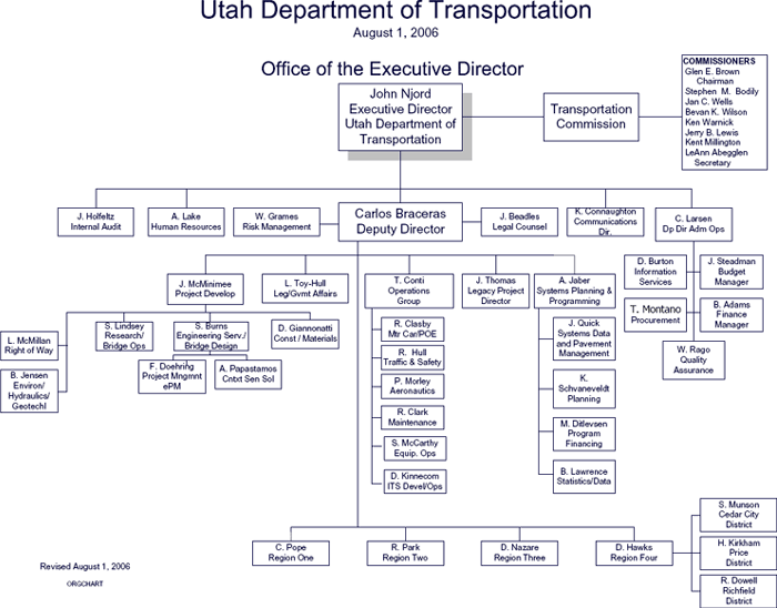
Like MDOT, UDOT operates in a somewhat decentralized fashion. Project recommendations are made at the headquarters or central office through tactical and strategic asset management practices. These recommendations form the 10-year Preservation Plan and are incorporated into UDOT's SLRP. The two plans are then used by leaders within each of the department's four regions to produce the STIP that looks at four years of committed projects and a further two years of concept development projects. Also like Michigan, this allocation is informed by quality data and decision-support tools that have earned UDOT strong credibility with its politically appointed Transportation Commission, upper management, and state legislature. Exhibit 4-3 presents UDOT's organizational structure.
Exhibit 4-3: UDOT's organizational structure (Description)
Full-size PDF
Asset management principles have been adopted by UDOT's Systems Planning and Programming group, which includes the Systems Data and Pavement Management, Planning, Program Financing, and Statistics/Data divisions. Staff in these divisions collectively carry out the collection of system inventory and condition data, technical support for MPO models, project-specific traffic modeling, monitoring of system performance relative to performance standards, optimization of investment scenarios, and recommendation of resource allocation. Programming of preservation projects is based largely on the data and recommendations produced by the Systems Planning and Programming staff, but project selection occurs at the regional level.
In Utah, the Systems Planning and Programming group is the "champion" of asset management, and its success is evidenced by the credibility that their products enjoy with decision makers.
4.3.2 Major Components of UDOT's TAM Program
As with the other participant states, asset management at UDOT tends to be preservation oriented. The following are descriptions of the key components of UDOT's existing asset management program.
Focus on preservation
UDOT's policy is to address all preservation needs for existing infrastructure before committing funds to expansion projects. Given the limited availability of state funds and the common challenges of preserving an aging highway system, UDOT has had limited ability to fund expansion projects in the recent past. As in Michigan , this has resulted in the deferral of capacity-related projects. However, the strength and credibility of the asset management program's analyses have yielded increases in available funding for expansion projects, with positive impacts to the state's highway users.
Goals, objectives, and performance measures
UDOT has established its "final four" strategic goals, which are to "take care of what we have," "make the system work better," "improve safety," and "improve capacity." The TAM program addresses each of these goals through a variety of objectives, which include those listed below. UDOT has a policy that defines a hierarchy of how funds are allocated between three of the four strategic goals. Funds are allocated to: first, "take care of what we have;" second, "make the system work better;" and third, "improve capacity;" while dedicating funds to "improve safety." This prioritized ordering of these goals reflects the state's current emphasis on system preservation (the first goal) versus the travel demand-related goal of capacity improvements (the last goal).
- Take care of what we have.
- Maintain 90 percent of freeway pavements, 70 percent of arterial pavements, and 50 percent of collector pavements in fair or better condition.
- Maintain 65 percent of bridges in very good condition, 25 percent of bridges in good condition, and 10 percent of bridges in fair condition.
- Maintain a grade of "B+" for snow and ice removal. The maintenance management system assigns a grade for snow and ice removal, with A for "clear, dry conditions" and B for "occasional snow or ice build-up."
- Maintain a grade of "A" for signing and striping. The maintenance management system assigns a grade for signing and striping, with A for "excellent daytime and nighttime visibility" and B for "good daytime visibility and fair nighttime visibility."
- Make the system work better.
- Increase annual usage of 511 (phone) and CommuterLink (web) traveler information sources by 10 percent.
- UDOT will soon begin polling motorists to determine the percentage who change their travel patterns based on information received through 511 or CommuterLink. At this time, they have not established an objective relative to the information that will be gathered through the polls.
- Clear non- or minor-injury crashes in 30 minutes or less on average, serious-injury crashes in 60 minutes or less on average, and fatal accidents in 120 minutes or less.
- Improve safety.
- Reduce the number of traffic-related fatalities by 2 percent each year.
- Reduce the number of pedestrian fatalities by 2 percent each year.
- Increase capacity.
- UDOT is measuring baseline travel times between various intersections along the Wasatch Front (Interstates 15 and 80 in the Salt Lake City area). Once a baseline has been determined, UDOT will establish objectives relative to travel times.
"Baseline" asset management tools
As with each of the other study states, Utah employs pavement management, bridge management, and maintenance management systems for the ongoing maintenance of highway and highway-related infrastructure. Each of these systems is supported by databases housing inventories of the state's highway related assets including pavement, bridges, signs, guard rails, and other facilities. UDOT has integrated these tools into a comprehensive asset management system (AMS).
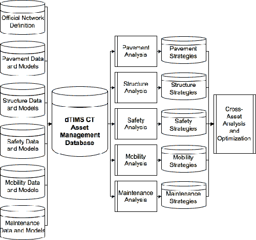
Data collection and distribution
UDOT has developed an AMS within the commercially available software package called dTIMS CT. The AMS uses data and models from the other tactical management systems and houses data similar to MDOT's TMS, including asset information data such as inventory, conditions, and crashes, and travel demand data such as AADT and travel forecasts. Data related to TAM are collected similarly in Utah as in other states; each management system (bridge, pavement, safety, and maintenance) has its own source.
- Bridge: Bridge data are collected and maintained in PONTIS through biannual inspections. PONTIS data are exported to the AMS for an overall network analysis and then, once the network-level analysis is completed, analyzed within PONTIS to determine project-level decisions.
- Pavement: Pavement data are collected through an annual distress survey, which consists of both automated and manual components (manual "asphalt ride" windshield survey and automated International Roughness Index tests). The pavement management group uses its own dTIMS CT database to store and analyze the pavement data to produce the pavement management program.
- Safety: Raw accident data are summarized and a safety index calculated by the asset management team at UDOT using three-year average crash statistics stored within dTIMS CT. This safety index is then analyzed within dTIMS CT to produce a safety program, which is then provided to Traffic and Safety for final program development.
- Maintenance: UDOT's maintenance management system consists of work histories and annual inspections of facilities statewide. These data are currently exported to the AMS, and a preliminary analysis is completed within the AMS similar to the safety analysis.
UDOT then performs a strategic analysis, including cross-asset analysis and optimization across the asset groups. Currently, UDOT has implemented pavements, bridges, safety, mobility, and maintenance analyses into the dTIMS CT AMS.
System preservation processes and decision-support tools
Utah has completed the implementation of the decision-support software tool dTIMS-CT, which analyzes alternative infrastructure preservation and maintenance investment scenarios and produces "optimal" resource-allocation strategies. Although initially focused on pavement preservation alone, dTIMS CT has been implemented to allow for a more complete analysis of all project types, including pavements, bridges, safety, maintenance, and capacity projects. The goal of the AMS is to allow analysts to produce "apples-to-apples" measures of the benefits of all projects relative to UDOT's goals and objectives.
In recent years, the results of scenario analyses produced with the help of dTIMS CT are typically adopted as a baseline for consideration by decision-making bodies (including the four geographic divisions and the statewide Commission). UDOT maintains a high level of credibility with the state legislature and with transportation decision-making bodies because of its ability to present, with the help of dTIMS CT, the consequences of changes in levels and mixes of investments in preservation.
UDOT's toolkit for presenting information related to preservation needs includes a 10-year Preservation Plan as well as output from the dTIMS CT AMS.
| UDOT's dTIMS CT Asset Management System Software |
|---|
|
UDOT purchased the dTIMS CT software initially to serve as a pavement management tool, but has retained Deighton Associates Limited, the software developer, to assist with implementation of a more comprehensive, "enterprise-wide" Asset Management System (AMS). A key feature of UDOT's enterprise-wide effort was the implementation of an AMS that could consider and optimize investment strategies for one or more "asset groups." Examples of asset groups are pavements, structures (e.g., bridges), safety, and maintenance; most state DOTs have developed or are developing similar management systems. UDOT has expanded that list, however, to include mobility as an asset. While deterioration for pavements and bridges follow predictable patterns that can be represented as curves, UDOT has suggested developing a similar curve that tracks and predicts the deterioration of mobility over time based on current congestion data and travel demand forecasts.
UDOT's AMS within dTIMS CT has been configured by UDOT and Deighton to have the following capabilities:
Conceptually, UDOT's AMS functionality includes the ability to produce investment strategies within and across asset groups, including investment strategies related to both preservation and expansion of physical networks. The relationships built into the asset management database are illustrated above. |
UDOT's asset management strategy consists of four different levels of asset management analysis that are integrated to produce a consistent set of recommendations:
- Strategic Asset Management Analysis: Data and models from the tactical asset groups (Pavement, Bridge, Safety, Mobility, and Maintenance) are loaded into the dTIMS CT AMS and analyzed to determine budget allocations for each asset group using a traditional "stove pipe" or "silo" analysis as well as using the "cross-asset analysis and optimization" functionality of the AMS. These budget recommendations are presented ultimately to the Transportation Commission. Once the budget allocations are approved, the budgets as well as the output from the dTIMS CT AMS analysis are distributed to the different asset groups so that the tactical asset management analysis can be completed.
- Tactical Asset Management Analysis: The tactical asset management groups use the budget allocations and project recommendations from the strategic asset management analysis as input into the asset group systems. These inputs are entered into the respective asset group systems and the analysis completed using decision-support tools such as dTIMS CT and PONTIS as well as other manual data and processes to develop the recommendations from the tactical asset groups. The result of this analysis is a tactical program that forms the basis of the UDOT 10-Year Preservation Plan.
- Long-Range Planning: Once the 10-Year Preservation Plan is developed, the Planning Division then incorporates its recommendations into the SLRP, where transportation planning, travel demand, MPO input, and corridor development plans are completed. The SLRP may impact the strategic and tactical analyses, which may necessitate further analysis at the tactical and strategic levels as corridors are committed in specific years for redevelopment.
- Operational Asset Management: Finally, the UDOT Regions put together the STIP using recommendations from the strategic, tactical, and long-range plan components.
In time, UDOT desires to have all of the 10-Year Rehabilitation and Preservation projects and STIP projects come from the SLRP.
Capacity Improvement decision processes
Utah faces a constraint similar to Michigan for capacity-related projects, in that additional state resources have been dedicated to Utah State Legislature-earmarked projects. As a result, decision makers have not been faced with tradeoff decisions related to travel capacity projects and programs. Nonetheless, UDOT has expanded the dTIMS CT AMS capability to include consideration of capacity projects, which will allow for cross-asset allocation of resources among preservation, maintenance, and expansion investments.
In the absence of a dTIMS CT decision-support tool to prioritize capacity projects, UDOT's Project Planning and Programming Division is responsible for recommending capacity-related projects among the four UDOT regions based on travel demand. Prioritization is based primarily on historic population growth trends from the State Budget Office and the list of prioritized projects as identified by the regions.
Statewide Processes
Similar to Michigan, the concept of transportation asset management extends beyond UDOT and is currently practiced by a variety of local and county agencies around the state. Less structured than in Michigan, asset management at the local level within Utah is autonomous from other towns and counties and is also less influenced by UDOT's own TAM program. Here communities desiring asset management can reach out to the Utah Local Technical Assistance Program (LTAP) Center. This center was established to:
- Transfer highway technology from FHWA, UDOT, and universities to local transportation agencies
- Provide an avenue of feedback from local transportation agencies to UDOT, FHWA, and universities on local transportation needs.
The Center is working with communities desiring asset management to collect data on the configuration, condition, and performance of locally owned roadway infrastructure and then help the locality develop its own re-investment programs using LTAP's own decision support software. As with Michigan , this broader application of asset management principles within the state ensures that a greater proportion of roadway assets are governed by such principles (i.e., more than the roughly 10 percent of center-line miles maintained by UDOT).
| UDOT and MDOT asset management at the local level |
|---|
|
All states participating in this study are focused on developing asset management practices for application at the statewide level to state-owned assets. Yet, with the exception of North Carolina, state DOTs own fewer than 10% of highway centerline-miles. The majority of the remaining facilities are owned and managed by counties and municipalities. In both Utah and Michigan, asset management principles are being promoted at these local levels. In Michigan, the legislature established an Asset Management Council, independent from MDOT, which is responsible for coordinating asset management activities with all 617 highway-owning agencies across the state, including counties, cities, townships, and villages. The Council distributes technical guidance and supports pavement condition data collection and analysis using the RoadSoft software program. In Utah, FHWA's Local Technical Assistance Program (LTAP) was established at Utah State University in 1988. LTAP transfers technologies and technical guidance from FHWA, UDOT, and universities to local agencies through workshops, a lending library of various informational products, newsletters, and special projects. One special project developed an asset management tool for local agencies. The tool comprised basic inventory, condition, and forecasting components that local agencies could use to monitor and predict needs, including needs for maintenance of signs, signals, pavements, and other assets. |
4.3.3 Travel Demand Measurement and Forecasting Capabilities
Current measures of travel demand
Utah tracks current measures of travel demand through traffic counts throughout the state highway system. These counts are reported as AADT and by vehicle type ("classification counts"). Volume estimates are derived from 48-hour counts and summarized monthly and annually for each state route. Data are collected annually for the entire network.
Travel demand forecasting
UDOT currently does not produce a statewide travel demand model; however, there are four MPOs in Utah, each of which produces a regional travel demand model. UDOT provides technical assistance to three of these MPOs. Input data for the models include traffic counts from the primary highway network and projected growth rates in population. UDOT does have a statewide traffic forecasting tool that draws on 10 years of AADT records to estimate future levels of traffic along the state highway network. All of these activities take place within the Planning Division. These future levels of AADT are loaded into the dTIMS CT AMS for use in the analysis of the various assets considered within the AMS.
4.3.4 Links Between TAM and Travel Demand Measures
Following are documented ways in which travel demand data are used by UDOT to support asset management processes or where asset management processes are used address future travel demand issues.
Roadway wear
UDOT does not use measures of travel demand to predict future deterioration rates of highway infrastructure. Rather, UDOT follows the common practice of using estimates of future ESALs during initial pavement design for a new or rehabilitated facility. The dTIMS CT model will then assume that the deterioration of that pavement will reflect the average deterioration rate for that pavement type and thickness, with no consideration of the potential acceleration (deceleration) of pavement wear due to higher (lower) than expected traffic volumes.
As with the other participant states, UDOT also conducts annual condition inspections of pavement throughout its network. These annual inspections provide an alternate means of capturing the impacts of accelerated (decelerated) pavement wear due to high (low) traffic volumes.
Investment prioritization
UDOT prioritizes preservation projects (e.g., pavements and bridges) based on their benefits and costs using the dTIMS CT optimization, decision-support software tool. dTIMS CT estimates user benefits for preservation projects (including bridges, pavements, and maintenance) by incorporating travel demand measures (e.g., VMT) as a factor in the project evaluation score, similar conceptually to the MAPSCORE program in Michigan . Outputs that the system produces can include any of the following:
- Funding levels required for any single asset group to meet a performance standard
- Performance levels for any single asset group based on funding levels
- Optimal maintenance and rehabilitation strategies for any single asset group based on any conceivable funding scenario
- Optimal funding levels between all asset groups through cross-asset analysis and optimization
- Performance of all asset groups based on funding levels.
Regions use these recommended prioritization lists as starting points for determining the projects in which they would prefer to invest.
Capacity improvement requirements
Capacity expansion in Utah is constrained by a combination of the UDOT policy that preservation needs be addressed first and a lack of available funds to address all preservation needs. However, the prioritization process for capacity is based on the statewide travel demand model and MPO models, which identify areas of high congestion.
In the absence of a more sophisticated dTIMS CT model to prioritize capacity projects, UDOT's Project Planning and Programming Division is responsible for recommending capacity-related projects among the four UDOT regions and does so based on forecast travel demand (from local MPOs) and from the output of a preliminary analysis within dTIMS CT. Final prioritization is based primarily on historic population growth trends from the State Budget Office and the list of prioritized projects as identified by the regions.
Safety
Utah does not currently use travel demand measures to help identify areas for safety investment.
Trade-offs between preservation and capacity enhancement
Once again, UDOT policy is that all preservation needs be met before allocating funds to capacity enhancement. This and the state's funding constraints prevent UDOT from addressing most capacity needs. At the same time, UDOT's "final four" strategic goals are:
- Take care of what we have (i.e., preservation)
- Make the system work better (i.e., operations)
- Improve safety
- Increase capacity.
Together, these constraints and prioritized goals effectively pre-determine the investment tradeoffs for preservation versus capacity improvements. Despite these constraints, UDOT is moving ahead to expand the dTIMS CT-implemented mobility models to conduct more sophisticated analytical tradeoff analyses between preservation and capacity improvements.
Performance Measures and Objectives
UDOT has established performance measures that align with the four strategic goals listed above (preservation, operations, safety, and congestion). The agency has not yet, however, defined standards for the congestion performance measure (travel times between various intersections along Interstates 15 and 80 in the Salt Lake City area) because of difficulty in establishing baseline travel times. Performance is reported annually.
4.4 California DOT (Caltrans)
4.4.1 Organizational Structure of the State DOT
Exhibit 4-4 presents MDOT's organizational structure.
Exhibit 4-4: Caltrans' organizational structure (Description)
Full-size PDF
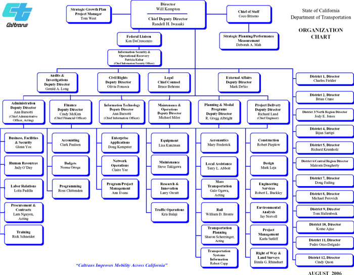
Caltrans does not currently have staff dedicated wholly to "asset management." The organization's leadership, however, is establishing organizational and transportation system performance measures that ultimately will spread throughout Caltrans and help to shape the way that the state invests in infrastructure. In addition, there are several asset management-related activities ongoing within various segments of the organization. First, the Transportation Systems Information division collects and maintains inventory data for Caltrans highways. Also, staff within Maintenance and Operations utilize pavement, bridge, and maintenance management systems, which are used to help prioritize projects within each of those areas.
Capacity projects and preservation projects in California are developed and programmed separately. Capacity projects are identified and developed by staff in the Planning and Modal Programs group, and these projects ultimately, with input from Districts, are programmed into the STIP. Preservation, maintenance, and operations projects and programs, on the other hand, are identified by staff in the Maintenance and Operations group and ultimately are programmed into the State Highway Operations Preservation Program (SHOPP).
4.4.2 Major Components of Caltrans TAM Program
Despite the absence of an official asset management program, Caltrans staff were eager to participate in the study with the objective of learning more about asset management practices and how the state can benefit from the experiences of other states. The following describes those management processes utilized by Caltrans that most closely match the roles, responsibilities, and principles of TAM.
Performance measures
Caltrans recently began developing high-level organization-wide goals and performance measures, including measures that apply to Caltrans organizationally and others that apply to the performance of the transportation system. This program enjoys the support of upper management and ultimately aims to provide common goals, objectives, and measures for use across the organization. Key organization-wide goals include:
- Safety: Provide the safest transportation system in the nation for users and workers.
- Mobility: Optimize transportation system throughput and provide dependable travel times.
- Delivery: Improve delivery of projects and services.
- Flexibility: Provide mobility choices through strategic partnerships.
- Stewardship: Preserve and enhance California 's resources and investments.
Here mobility is the only goal relating directly to travel demand concerns.
Caltrans also publishes a 10-year SHOPP Plan, which identifies all system preservation needs for the upcoming 10-year period. Project selection for the 2005 ten-year SHOPP Plan was guided by the following goals (closely related to the agency wide goals as stated above):
- Safety: The Plan includes strategies and targeting funding levels that will improve motorist and worker safety.
- Performance: The Plan includes operational, technology, and system management improvements that optimize the system throughput.
- Reliability: The Plan identifies the preservation and rehabilitation needs of the State's bridges and highways to maintain a reliable system. The Plan also identifies mobility and operational needs to reduce congestion and increase reliability.
- Stewardship: The main objective of the Plan is to preserve and protect the State Highway System, one of the State's most valuable resources.
Note that the above strategic goals and objectives, even those specifically addressed by the SHOPP plan, are aimed at both preservation- and capacity-oriented needs. In addition, the DOT-wide objectives have not yet been applied to or refined by asset managers or other divisions within Caltrans for whom the objectives are intended.
"Baseline" management systems
California's current asset management activities are focused on the traditional suite of management systems for assets, including bridge, pavement, and maintenance management systems. These systems are used to house and manage transportation system data. In addition, these tools include features that allow users to analyze various investment scenarios to better understand the impacts of allocating resources. For example, Caltrans uses PONTIS as a tentative baseline estimate of bridge needs, but the software does not capture some risks well (e.g., seismic and scouring problems). Consequently, analysts combine PONTIS results with other information to develop estimates and allocation recommendations manually. As another example, the pavement management system produces similar results as PONTIS, but also encounters a similar shortcoming - the investment scenario recommended by the system serves as a baseline, but is subject to substantial revisions by analysts based on other information.
Data collection and distribution
| Caltrans' Integrated Transportation Management System (ITMS) |
|---|
|
Caltrans has been developing and refining its Intermodal Transportation Management System (ITMS) over the past several years. ITMS is a macro-economic tool designed to provide comprehensive analysis of and coordination of planning for a broad range of transportation projects spanning all modes, accessible to planners from all twelve Caltrans Districts and other planning agencies. Completing the ITMS involved the establishment of multimodal performance measures across modes in five key areas: mobility, financial, safety, economic development, and the environment. In addition, Caltrans developed demand and cost data for passenger and freight movements (all modes) for the base year, and for 10-, 20-, and 30-year horizons. Ultimately, this led to the provision of a computer and database architecture capable of integrating data analysis, forecasting, and GIS capabilities. ITMS includes the major functions of asset management; specifically, it recognizes performance measures, provides planners at several levels the ability to coordinate project planning by using common data, develops consistent information, and performs credible analyses that support better decision making. |
Asset inventory, condition and performance data are collected by several distinct Caltrans divisions:
- The Division of Transportation Systems Information (TSI) provides Geographic Information System (GIS) capabilities through its Office of GIS.
- The Division of Operations collects and maintains crash data in the Traffic Accident and Safety Analysis System (TASAS).
- The Division of Maintenance's Roadway Program performs visual and instrumented (International Roughness Index) pavement inspections annually for all state-owned roads and manages these data in a pavement management system database.
- The Division of Maintenance's Office of Structure Maintenance and Investigations performs bridge condition inspections biannually for all state-owned bridges. Bridge inspections consist of a condition report and additional information based on the professional opinion of the inspectors, all of whom are licensed engineers. Additional information could include, for example, information about vehicular traffic, if the engineer deems traffic to be a significant feature of a particular bridge. Bridge data are managed by the Office using PONTIS.
- The Division of Maintenance's Integrated Maintenance Management System (IMMS) is currently being further developed and will allow for a centralized repository of data related to work performed on specific pieces of the system and costs of maintenance
System preservation processes and decision-support tools
The recommendations of the SHOPP (preservation plan) are generally approved by the State Transportation Commission because SHOPP's preservation-oriented projects and built-in prioritization process have input from both district engineers and statewide asset managers. Within this plan, the prioritization of preservation funds between pavement, bridges, and maintenance is determined by a combination of historic funding allocations to each of these uses and upper management decisions based on the input of regional engineering staff and headquarters staff responsible for each asset class (i.e., there are no decision support tools to support this process). In addition, the 10-year SHOPP Plan, which projects future preservation needs, offers decision makers a "preview" of future SHOPPs.
Caltrans does not actively utilize any decision-support tools beyond traditional management systems for assets, but is working to re-implement its Intermodal Transportation Management System (ITMS) tool (see callout box).
Capacity improvement decision processes
There is no rigorous analytical decision-support process for capacity-related projects at the statewide level in California, the reason being that 75 percent of available STIP (i.e., capacity improvement) funds are allocated to independent regional transportation planning agencies (RTPAs) as defined under state statute. Consequently, those agencies, which include MPOs, conduct their own investment prioritization analyses with minimal input from headquarters staff. This decentralized approach, in which each region is free to use its own methods to prioritize projects, leads to varying levels of sophistication with regard to project selection. The 25 percent of available STIP funds that are allocated to interregional projects, as part of the Interregional TIP (ITIP), meanwhile, are distributed based on an allocation formula to projects that are consistent with priorities described in the statewide Interregional Transportation System Plan (ITSP).
Overall, decision makers have few "levers" to pull with regard to the allocation of expansion project funding in California due to the formula allocation of resources programmed into the STIP. Decision makers can, however, impact the total allocation to the STIP. In fact, recently, the STIP allocation were temporarily suspended as a consequence of the state's recent funding problems. If funding is restored, the total funding levels will be at the discretion of lawmakers, with allocation again relying on the STIP formulas.
Limited resources
Given its high rate of growth and diverse needs, California has felt resource constraints more acutely than other states. For example, whereas other states program expansion projects and some preservation projects as part of a STIP, California transportation agencies develop two distinct programs, one for expansion-related projects (STIP) and another for highway preservation- and operations-related projects (SHOPP). In recent years, funding for the STIP has been committed to other non-transportation needs of the state. In this regard, Caltrans staff agreed that the state has become "preservation-focused," despite the growing travel demand.
4.4.3 Travel Demand Measurement and Forecasting Capabilities
| Statewide travel demand models |
|---|
|
Statewide travel demand models are a "recent phenomenon," with the most advanced models emerging in the last 10 years. The participating four states are at varying stages of model development, reflecting the fact that across the nation many states have yet to develop any models, others are considering investment in a model, and still others have developed sophisticated models that consider all modes of passenger and freight travel, drawing on numerous sources of data. Statewide travel demand models help DOTs to think more strategically about where future capacity investments will provide the highest long-term payoff. Benefits include:
|
Current measures of travel demand
The Division of Traffic Operations' System Management Planning group conducts an annual screen-line survey (traffic count). This survey gathers sample counts of traffic volumes, including trucks, at numerous points of the state highway network, reported annually as AADT. In addition, the Motor Vehicle Stock, Travel, and Fuel Forecast (MVSTAFF) estimates current and future projected numbers of registered vehicles, VMTs, and fuel consumption.
Travel demand forecasting
The TSI's Office of Travel Forecasting and Analysis produces and manages the statewide travel demand model, which projects VMT and volume-to-capacity ratios on the intercity state highway network based on a decennial household travel survey. Modes included in the model, which projects travel from 2000 to 2025, include air, rail (Amtrak), intercity bus, and highway. This information is provided as requested by MPOs and RTPAs as an input to their regional travel demand models. Travel demand forecasts are also often produced by TSI on smaller scales to support project-specific analyses. The Office also produces an annual MVSTAFF report, which estimates current and future projected numbers of registered vehicles, VMTs, and fuel consumption (forecasts are based on current and projected socioeconomic attributes such as population, income, fuel price, interest rates, and assumptions regarding fuel economy).
In the past, TSI has relied on screen-line truck counts to model truck flows on the intercity network. Staff indicated that these data are not reliable and that the division is currently undertaking a study to construct a truck model
4.4.4 Links Between TAM and Travel Demand Measures
Following are documented ways in which travel demand data are used by Caltrans to support asset management processes or where asset management processes are used to address future travel demand issues.
Roadway wear
Caltrans does not currently use measures of travel demand to predict asset deterioration. As with the other states, however, ESAL projections are used in pavement design.
Capacity improvement requirements
Capacity improvements in California fall under the STIP and are funded according to a formula-based allocation process. Formulas stipulate the following:
- 25 percent of available STIP funds are allocated to the ITIP
- 10 percent for "flexible use" interregional projects
- 2.25 percent for intercity rail
- 12.75 percent for non-urban interregional roads
- 30 percent of STIP funds are allocated to Northern California counties
- 45 percent of STIP funds are allocated to Southern California counties.
Funds allocated to the counties (which account for three-quarters of all STIP funds) are distributed based on two weighted criteria: population, which is weighed 75 percent, and state highway mileage, which is weighed 25 percent. Given this formula, the selection of capacity investments is made primarily at the regional level, with little consideration of statewide travel demand issues.
Safety
Safety investments made through the SHOPP in California are based on a traffic safety index score. This score does not explicitly include a measure of travel demand. In addition, California also utilizes the practice of pre-positioning emergency response crews on high-volume highway segments during peak-period travel as a means of accelerating accident response and traffic flow restoration.
Trade-offs between preservation and capacity enhancement
STIP and SHOPP resources are allocated under distinct processes and are driven by eligibility of funding under various state and federal programs. As a result, there is no tradeoff analysis between investment alternatives within these two programs. For example, since SHOPP needs exceed available federal and state resources, all state and federal funds that are legally eligible for SHOPP programs are allocated to SHOPP. On the other hand, some federal (e.g., TE) and state (e.g., California Proposition 42 and Public Transportation Account spillover funds) are only eligible for STIP projects. In recent years, however, resources have been re-allocated from the STIP to meet California 's non-transportation financial needs.
Performance measures and objectives
Caltrans has developed organizational and system performance measures to guide its operations and decisions related to transportation infrastructure and service provision. Organizational performance measures have been coupled with targets for improvement. Targets have not yet been set, however, for system performance measures (e.g., travel demand and congestion-related measures).
4.5 North Carolina DOT (NCDOT)
4.5.1 Organizational Structure of the State DOT
NCDOT is responsible for operating and maintaining over 75 percent of North Carolina's roadway miles, a far larger share of statewide highway miles than any of the other study participants. (Note: The other state DOTs maintain roughly 10 percent of their state's total center-line miles.) State law also requires that 90 percent of North Carolina residents have access to a four-lane, divided highway within five miles of their homes. Furthermore, recent and projected population growth rates in North Carolina are among the fastest in the nation. These characteristics make NCDOT a unique organization in that it must simultaneously address system preservation and capacity needs for an unusually large infrastructure network.
NCDOT's Transportation Planning Branch is responsible for a statewide long-range strategic plan, technical support for MPO models, and programming of capacity-related projects. Although districts and MPOs identify projects for capacity expansion, planning staff are also responsible for coordinating the process and providing technical assistance as projects move from identification to the programming stage. Next, projects are selected by the state Transportation Board in a programming process that involves resource negotiation among members, subject to financial constraints and legal requirements, and results in a STIP.
The long-range strategic plan was initiated by NCDOT leadership and has retained the support of upper management. Although carried out by the Planning Branch, the long-range plan involved numerous divisions of NCDOT, defined strategic goals and objectives, identified the various investment needs of the transportation system, and suggested courses for meeting the needs of the system (e.g., moving from capacity expansion toward preservation).
The Operations Branch includes an Asset Management staff that oversees bridge, pavement, equipment, roadside, and other maintenance units. Where the Transportation Planning Branch identifies capacity needs, the Operations Branch identifies system maintenance, preservation, and operations needs. Funding of maintenance, preservation, and operations needs occurs independently of the TIP process and comes directly from the state legislature.
4.5.2 Major Components of NCDOT's TAM Program
Legislative focus on expansion
Due to a legislative requirement to build out a pre-defined intrastate highway system, North Carolina has dedicated substantial funds to system expansion - significantly more than other states that participated in this study. Although the long-range plan suggests addressing more preservation needs, the high rate of population growth and policy considerations will continue to emphasize system expansion. The decision-making processes and programs that provide resources for capacity expansion, however, are balanced by realization of maintenance, operations, and preservation needs within the Asset Management division, as a result of data-driven analysis and relatively strong linkages among staff in asset management, planning, and other functional areas.
Asset management program focus on preservation
As noted earlier, NCDOT is responsible for more than 168,000 lane-miles statewide or more than three-quarters of the state's total center line miles and more than 17,000 bridges. Given the state legislation's requirement for ongoing build out of an extensive intrastate system combined with a program to pave dirt roads and the expansion of local roads by the state's developers, the number of road miles under NCDOT maintenance is expanding by more than 400 miles each year. Ongoing maintenance and preservation of this extended roadway network places significant demands on the state's budget and NCDOT's resources. Within this constrained environment, asset management processes have evolved as the optimal method for sustaining the existing roadway network.
TAM performance measures and standards
NCDOT is in the final stages of completing a multi-year process of developing performance measures and performance standards for each of the activity areas encompassed by the state's asset management program. These activities include maintenance, pavement, bridges, traffic/ITS, roadside, and construction. For each of these activity areas, NCDOT's TAM program has identified multiple asset specific performance measures, with over 100 difference performance measures and related performance targets identified in all. In accordance with the TAM program's emphasis on preservation, the selected performance measures are dominated by measures relating to system preservation, with relatively few measures relating to travel demand-related concerns. For example, the bridge unit includes measures such as "percentage of bridges exceeding the National Average" deficiency rating and "percentage of overhead sign structures rated 'good.'" The traffic/ITS unit includes several preservation related measures (e.g., "linear feet of pavement markings visible at night"), but also includes the indirect travel demand measure "incident clearance times." Only a small number of measures relate either directly or indirectly to travel demand issues. This is to be expected as travel demand is not a current focus of NCDOT's asset management program.
High-level support
Both the statewide long-range plan and the asset management program enjoy support at high levels of NCDOT. This high-level support and the identification of common goals and objectives at all levels of management is crucial to the long-term success of any asset management program.
"Baseline" asset management tools
As with each of the other study states, North Carolina employs pavement management, bridge management, and maintenance management systems for the ongoing maintenance of highway infrastructure.
Data Collection
NCDOT's TAM program, organizationally a part of the Bureau of Operations, has numerous data collection and management responsibilities. Much of this data is available to other DOT users and some data (e.g., pavement condition) are available to the general public as well.
Data maintained by NCDOT's TAM program include:
- Inventory: NCDOT's asset inventory includes pavements, bridges, and signals. NCDOT does not currently maintain an inventory of roadside items, such as signs and culverts, due to the "overwhelming" size of the system for which the Department is responsible.
- Pavement: Condition data for pavements are collected through annual inspections of the interstate network and biennial inspections of other roadways. Pavement inspections include a 100-percent survey of all flexible pavements and a sample of the first one-tenth mile of each mile for rigid pavements. Survey data are reported as distresses (PCR, ranging from 0 to 100), and are made available on the NCDOT web site for all internal and external users. PCR ratings are available for each of the last 15 survey years.
- Bridges: Condition data for bridges are collected through annual inspections.
- Traffic/ITS: Although the state does not currently inventory ITS devices, signals, signs, or pavement markings, this division is responsible for monitoring performance of such assets to inform the decision-making process.
System preservation decision processes
Like California, North Carolina 's project selections occur primarily at a decentralized level, with the majority of analysis for project prioritization occurring inside of MPOs and regional planning agencies (RPAs). Further analysis occurs at NCDOT Regions before final resource negotiations among the statewide programmers. The decision-making process for inclusion in the STIP occurs at the MPO and district levels before analysis at the statewide level and ultimately the opinion of the Board of Transportation.
NCDOT does not require a standard procedure for analyzing and prioritizing travel demand-related needs within each region, in part because the goals of each region differ (e.g., mobility versus safety versus economic development). Much of the funding for preservation projects in North Carolina is derived from an annual legislative appropriation.
Capacity improvement decision processes
Capacity investments in North Carolina are a reflection of the state's legal requirements and the funds available that are specifically programmable only for new capacity. The processes used to identify which network components will receive resources first, however, are not currently based on explicit measures of travel demand or economic analyses, but rather on a scoring formula. The state allocates 25 percent of funds equally across all districts, 25 percent based on the number of intrastate system miles left to complete, and the remaining 50 percent based on district population (thereby implicitly considering travel demand).
Decision-support tools
NCDOT will soon unveil a new benefit-cost analysis tool that will inform the decisions of the Transportation Board's programming of capacity expansion projects. As in Utah, the tool is not intended to remove the resource allocation decision from human decision makers, but rather to provide Board members with additional, higher-quality, objective information that speaks to the varying performance goals of districts (e.g., mobility, economic development, and safety).
4.5.3 Travel Demand Measurement and Forecasting Capabilities
Current measures of travel demand
NCDOT's Bureau of Planning tracks current measures of travel demand through annual traffic counts along its primary highway network, semi-annual traffic counts along its secondary network, and counts within MPOs every two to three years. Traffic counts are recorded manually in a map book, which is one of NCDOT's highest-use products. Project-specific counts are also performed; these special counts include vehicle-type classifications, turning movements, and peak versus non-peak flows.
Travel demand forecasting
NCDOT currently does not produce a statewide travel demand model but does provide technical support to the regional models for small- and mid-size MPOs (there are 11 total MPOs in North Carolina ). Travel demand forecasting capabilities are also used to support cost-effectiveness analyses for major investment projects.
4.5.4 Links Between TAM and Travel Demand Measures
Following are documented ways in which travel demand data are used by NCDOT to support asset management processes or where asset management processes are used to address future travel demand issues.
Roadway Wear
NCDOT does not currently use measures of travel demand to predict asset deterioration. As in other states, however, ESAL projections are used in pavement design.
Re-investment prioritization
Transportation investment prioritization occurs within each district in North Carolina , but ultimate authority to allocate resources resides with the state's Transportation Board. Resource allocation among divisions by the Board does not explicitly consider travel demand measures.
Capacity improvement requirements
Capacity investments in North Carolina are a reflection of the state's legal requirements and the funds available that are specifically programmable only for new capacity. The processes used to identify which network components will receive resources first, however, are not currently based on explicit measures of travel demand or economic analyses, but rather on a scoring formula. The state allocates 25 percent of funds equally across all districts, 25 percent based on the number of intrastate system miles left to complete, and the remaining 50 percent based on district population (thereby implicitly considering travel demand).
Safety
Travel demand measures are not explicitly considered in decision-making processes for safety projects. However, each NCDOT region has a unique goal relative to transportation investment (e.g., congestion relief, economic development, and safety enhancement). The mix of projects selected by a district reflects its interests-meaning that some districts may identify more safety-related improvements than others.
Trade-offs between preservation and capacity enhancement
Allocation of resources between preservation, capacity, and other needs in North Carolina is subject to legal requirements, as in other states; however, state law actually requires that certain funds be dedicated to expansion of the highway network. Management and preservation needs, on the other hand, are addressed through annual legislative appropriations based on historical trends and the needs identified by NCDOT staff.
Within this environment, NCDOT will soon unveil a new benefit-cost analysis tool that will provide decision makers on the Transportation Board with a complete picture of the benefits of all potential projects, including preservation- and capacity-oriented projects. This tool is expected to make use of VMTs or other travel demand-related measures to scale the size of investment-related travel time savings and other traveler-oriented benefits.
Performance measures and objectives
NCDOT uses performance measures in a variety of areas. For example, the traditional asset management functions (bridge, pavement, roadside, operations, etc.) each are in the process of refining numerous performance measures that ultimately will be used to guide investment within each particular area. Broader performance measures are discussed in the statewide long-range transportation plan, including those related to travel demand management and congestion and efficiency. However, no targets are used as part of a process to help identify specific investment needs.
4.6 Summary
Linkages between TAM and travel demand vary from state to state, but largely remain formative. Travel demand data are occasionally used explicitly to inform TAM analyses (e.g., determining benefits of preservation projects based on VMT), but are mostly considered implicitly (e.g., using population growth in decision-support tools to determine resource allocation). Specifically, this review observed the following:
Current and projected travel demand measures as inputs to the TAM process
- Roadway wear: While current travel demand measures are frequently captured implicitly by agency asset management needs analyses (e.g., through annual segment-by-segment roadway condition evaluations), these measures are rarely incorporated explicitly into analyses of infrastructure deterioration rates or the subsequent maintenance and rehabilitation requirements.
- Investment prioritization: Only one of the four study states (Utah) has developed a decision support tool that uses travel demand-driven investment benefits to help prioritize short-term preservation investments between locations or regions.
- Project benefit-cost and alternatives analysis: Virtually all of the participant states regularly incorporate travel demand measures when conducting benefit-cost analyses (or other cost-effectiveness assessments) of proposed major investment projects and their investment alternatives
Using the TAM process to address issues related to travel demand
- Capacity improvements: Two of the four participant states (Michigan and California) maintain statewide travel demand models and one (Michigan) maintains a truck model. These tools are critical to the objective and consistent identification of those travel corridors expected to suffer most from travel demand growth and hence having the highest priority investment needs.
- Trade-off analysis between preservation and capacity needs: None of the four states interviewed has yet succeeded in developing an objective and comprehensive process or a decision support tool to optimize the allocation of funds across multiple investment uses (e.g., preservation, capacity improvements, safety, beautification). They recognize that doing so will require the use of forecast travel demand measures to compare investment benefits.
- Objectives and performance measures: The current goals and objectives of the participant states' TAM programs reflect the current focus of these programs (i.e., maintenance and preservation) and hence place little emphasis on travel demand-related concerns (e.g., congestion). In contrast, the agency goals and objectives tend to be broader in scope and typically include the maintenance and improvement of mobility as a key goal.
TAM program focus
The TAM programs for each of the four participant states remain primarily focused on system maintenance and preservation. This focus reflects the history of each program's development (developing from a kernel of pavement and bridge management systems) and the particular investment needs, legislative requirements, and "color of money" limitations within each state. Moreover, most agencies tend to focus on the short- to medium-term investment needs, but place less emphasis on long-term objectives (e.g., mitigating congestion). This emphasis is reflected in their TAM program goals and objectives, which are also primarily focused on maintenance and preservation.
A key process currently used by agencies (either within or outside of their existing TAM programs) to consider and address long-term issues driven by ongoing growth in travel demand is the SLRP. The next chapter considers the current SLRPs of the four participant states, with emphasis on what these documents reveal about each state's plans to address the consequences ongoing travel demand growth. In addition, the chapter also considers how states are preparing long-term budgets to meet all transportation investment needs.
| << Previous | Contents | Next >> |