

April 30, 2020
Innovation of the Month:
Unmanned Aerial Systems
Last week, we looked at benefits from synergies between unmanned aerial systems (UAS), 3D modeling, Construction Management/General Contractor (CM/GC) project delivery, and e-Construction in Utah. UAS can also create new opportunities for agencies to enhance other critical project activities in ways that benefit both the agency staff and the natural environment.
UAS have been a beneficial tool for the Utah Department of Transportation (UDOT) in its environmental data collection efforts. According to UDOT, UAS allow the department to collect highly accurate, detailed imagery and dense point clouds in surveys. This has increased the quality, speed, and safety of data collection. On past projects, it was difficult for surveyors to navigate through dense vegetation. At times, this required surveyors to crawl under vegetation to find locations where elevation points could be collected. Older surveying technology made it necessary to cut through vegetation to obtain line-of-sight, or to achieve an open sky canopy to collect data. This made it very difficult, if not impossible, to collect data using conventional surveying methods in sensitive areas.
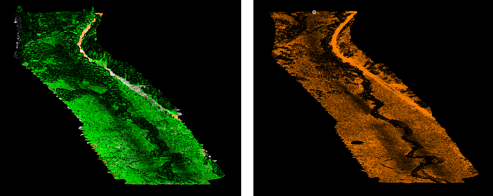
UAS-based light detection and ranging (LiDAR) has been an extremely efficient and valuable tool for the department. UDOT has used LiDAR to penetrate through vegetation, which has drastically increased the quality of data sets. It also allows data collection without disrupting the environment. At the US-40 Strawberry Reservoir passing lanes - wetland mitigation project, the area had thick vegetation and an accurate survey of the stream bank was a project requirement. Conventional surveying methods would have taken a three-person crew several weeks to obtain an accurate survey at this site. Using UAS, UDOT was able to collect the survey data in only a few hours. It also provided a higher density of points, which created a more accurate data set than was ever possible using traditional methods. UDOT plans to continue flying this area periodically to analyze changes over time. By using UAS LiDAR, UDOT predicts saving over $2.5 million within 5 years on transportation projects.
Other States are also interested in using UAS for environmental applications. The Nebraska Department of Transportation has developed a scope of services to build a wetlands predictive model using UAS-collected data (multi-spectral imagery and LiDAR). During the 2020 growing season, they will test this new procedure against conventional processes at five project sites.
To learn how your agency can incorporate UAS into its environmental data collection programs, contact James Gray or John Haynes with the EDC-5 UAS team.
WYDOT Adds Feature to Mobile App to Push Crowdsourced Data to Public
The Wyoming Department of Transportation (WYDOT) developed a hands-free mobile app for reporting conditions on and off highways statewide. The app allows citizens and WYDOT staff to submit text and images, which are geo-located and sent to the traffic operations center for verification.
Once verified, the system now has a backend feature that allows the information to be automatically pushed back to app users as well as to the 511 traveler information website. This ability will help WYDOT identify appropriate resources and reduce response times and the potential for secondary crashes. To further enhance communications, WYDOT is also developing a prototype function to alert emergency managers automatically in each county of relevant crowdsourced reports.
To learn more about how crowdsourcing can help your State develop innovative practices such as these, contact James Colyar or Paul Jodoin with the FHWA Office of Operations.
Caltrans Moves FoRRRwD to Improve Local Road Safety
In California, over 800 people die each year due to a roadway departure on a rural road. That is more than two people lost every day. Over 60 percent of these occurred on local roads. The California Department of Transportation (Caltrans) is moving FoRRRwD by dedicating $10 million of their safety funding for local agency roadway safety improvements. For agencies to obtain the funding, the state requires a Local Road Safety Plan (LRSP) in future funding cycles that identifies a 4E approach (engineering, education, enforcement, and emergency medical services) to local agencies’ safety priorities.
Working with Caltrans, FHWA provided comprehensive training to five counties to develop LRSPs. Now, those counties are assisting other counties in the state by sharing their successes and lessons learned through peer exchanges and statewide webinars. Together, this outreach and technical assistance has reached hundreds of local agency officials to assist them with making roads safer and reducing the risk and number of fatal and injury crashes.
The Focus on Reducing Rural Roadway Departures (FoRRRwD) team is here to help provide technical assistance in your State. To learn more about how your agency can receive technical assistance, contact EDC-5 FoRRRwD team leads Cate Satterfield or Dick Albin.
About EDC
Every Day Counts, a State-based program of the Federal Highway Administration’s Center for Accelerating Innovation, works with State, local, and private sector partners to encourage the adoption of proven technologies and innovations to shorten and enhance project delivery.