U.S. Department of Transportation
Federal Highway Administration
1200 New Jersey Avenue, SE
Washington, DC 20590
202-366-4000
Unmanned aerial systems (UAS), commonly known as drones, can benefit nearly all aspects of highway transportation by collecting data automatically or remotely. Multiuse aircraft controlled by certified operators on the ground, UAS offer improved safety, efficiency, and quality and reduced costs.
"It's compelling when you can touch on these four extremely important benefits with one technology," said James Gray, UAS and construction technology engineer for the Federal Highway Administration and a leader of the Every Day Counts round five (EDC-5) UAS team.
The EDC-5 team is promoting the use of UAS coupled with sensors such as high-definition cameras to enhance data acquisition for structural inspection, construction inspection, and emergency response. Forty-six States set a goal to demonstrate, assess, or institutionalize the use of UAS in transportation applications in 2019 and 2020.
The EDC-5 team is focusing on five UAS applications for structural inspection: bridges, high-mast lighting, confined spaces, retaining walls, and tunnels. Structural inspection enhanced by UAS improves safety for the inspection team and the traveling public by reducing the need for temporary work zones.
Construction inspection applications in which UAS are beneficial include surveying, project scoping, and work zone traffic monitoring. Construction inspection with UAS allows for an overhead view of a project's progress and for development of three-dimensional (3D) models that document construction processes and assist in earthwork quantity measurement.
UAS also prove useful in emergency response operations after roadway disturbances such as rockslides, avalanches, and floods and damage assessment after earthquakes, fires, and bridge hits. This relatively low-cost method allows agencies to obtain quality data quickly to make more informed decisions.
"We're seeing the emergence of UAS technology in all of these uses," said Gray. "There's a lot of excitement around UAS."

UAS technology can help agencies quickly and inexpensively survey damage during emergencies. Credit: FHWA
The Minnesota Department of Transportation (MnDOT) implemented UAS to support its bridge inspection program, particularly for bridges with difficult-to-access elements "We'll always use traditional inspection methods, but we were looking for other creative ways to gain access for bridge inspection," said Jennifer Wells, MnDOT State bridge inspection engineer.
As part of the UAS implementation process, MnDOT conducted field demonstrations to compare the effectiveness and safety of the technology to hands-on inspection methods. In one demonstration, the agency used UAS to inspect a small local bridge, a medium-size concrete arch bridge, a large steel truss bridge, and a railroad bridge over a river and compared the results to recent bridge inspection records.
MnDOT found that UAS can be an effective tool that reduces safety risks to inspectors from working in physically challenging situations and inconvenience to motorists from lane closures. UAS provided inspection detail that replicated some of the detail learned using under-bridge inspection vehicles while saving an average of 40 percent over the cost of traditional methods. UAS delivered infrared and 3D modeling detail of bridges, identified concrete delamination, and gathered topographic mapping detail.
"We learned that UAS can supplement inspections," said Wells. "We want to go statewide with this."
The Utah Department of Transportation (UDOT) uses UAS technology for rapid, high-quality data acquisition on jobs ranging from surveys to inspections. On a State Route 20 construction project, UDOT's first to use a 3D engineered model as the contract document, the agency deployed UAS to gather data to compare what was built with the 3D design model.
"By using this technology, we were able to get a bird's-eye view of the project," said Paul Wheeler, lead UAS coordinator for UDOT. "It gave us a whole new world of data to use."
Combining UAS use with the 3D model and e-Construction tools for inspection documentation resulted in overall project savings of about $83,000, increased workforce productivity by 45 percent, and enabled UDOT to complete the project 25 days ahead of schedule, Wheeler said. "We were surprised by how well the processes worked and plan to use them on more projects," he said.
Visit FHWA's UAS web page for State policies, research reports, and webinars on UAS in transportation applications.
Watch a webinar for an overview of how agencies use UAS in transportation applications.
Read Successful Approaches for the Use of Unmanned Aerial Systems by Surface Transportation Agencies for recommendations on what to consider when getting started using UAS technology.
Contact Benjamin Graybeal of the FHWA Turner-Fairbank Highway Research Center or Mark Leonard of the FHWA Resource Center for information and technical assistance.
Getting people to their destinations safely is a priority for transportation agencies. The Every Day Counts (EDC) focus on data-driven safety analysis (DDSA) nearly doubled the number of States that use advanced tools to more accurately predict the safety impacts of highway projects and target investment decisions more effectively.
While traditional analysis relies on subjective or limited quantitative measures of safety performance, DDSA applies modern software tools and methods to analyze crash, roadway, and traffic volume data. The tools quantify the expected safety impact of each decision in the project development process so agencies can make more informed choices and optimize investments. The result is fewer serious injury and fatal crashes.
DDSA became widespread in EDC rounds three and four, with 49 States attaining the demonstration, assessment, or institutionalized stages of implementation by December 2018. Four years earlier, 25 States used DDSA in project development.
The DDSA team promoted two strategies: Predictive analysis identifies sites with the most potential for improvement and quantifies the expected safety performance of project alternatives. Systemic analysis uses crash and roadway data to pinpoint roadway features that correlate with specific crash types.
"Agencies want to make their road systems as safe as possible, and once they learn about these new analysis tools, they are eager to use them," said Jerry Roche, safety engineer in the Federal Highway Administration Office of Safety and a DDSA team leader.
In addition to providing technical assistance and training to aid State agencies in incorporating DDSA into processes and policies, the EDC team helped local agencies gain proficiency with DDSA technology.
The California Department of Transportation (Caltrans) was among the agencies that implemented quantitative safety analysis methods in the American Association of State Highway and Transportation Officials Highway Safety Manual (HSM). The agency developed guidance for incorporating HSM methods into project analysis, building on a pilot effort using predictive analyses to quantify safety impacts of project alternatives, design exceptions, and performance-based practical design.
Caltrans also launched a project to create data definitions, quality assurance procedures, and performance measures so local agencies can collect data on Model Inventory of Roadway Elements, a list of roadway and traffic elements critical to safety management. The project results will allow Caltrans and local partners to perform robust safety analysis.
The Colorado Department of Transportation (CDOT) is also advancing DDSA at the State and local levels. On the State system, CDOT performed HSM-based crash prediction analysis using the Enhanced Interchange Safety Analysis Tool and Interactive Highway Safety Design Model. CDOT conducted predictive analysis to estimate the future safety performance of various projects, including the U.S. 160/550 interchange, Interstate 25 from Colorado Springs to Denver, Interstate 70 from Avon to Vail, and Interstate 70 express lanes from Empire to Idaho Springs.
On the local front, CDOT, the Colorado Local Technical Assistance Program (LTAP), and six local agencies participated in an FHWA pilot to develop local road safety plans (LRSPs). The pilot helped the agencies identify locations at risk for crashes and select low-cost countermeasures. The LTAP hosted an LRSP peer exchange to share information learned in the pilot with other Colorado cities and counties, and CDOT will continue the momentum by offering technical support for additional agencies to develop LRSPs.
The Arizona Department of Transportation (ADOT) and Maricopa Association of Governments (MAG) partnered with the Arizona Governor's Office of Highway Safety, local agencies, and law enforcement to deploy tools to enhance crash data quality and analysis, including an updated Arizona Crash Report Form, a new Arizona Crash Information System, and a predictive modeling tool. MAG also implemented DDSA-based infrastructure improvement projects through its Systems Management and Operations Plan and road safety assessment program.
The Ohio Department of Transportation (ODOT) institutionalized DDSA by incorporating safety analysis procedures into its Project Development Process. The procedures require varying levels of safety analysis based on a project's scope and complexity. As a result, ODOT will now consider safety performance on all highway projects, leading to more targeted investments that will help reduce fatalities and serious injuries on Ohio roadways.
An early DDSA adopter, the Missouri Department of Transportation (MoDOT) used DDSA to identify 31 locations with safety concerns as part of its Toward Zero Deaths strategy. Five design-build teams competed to offer MoDOT cost-effective safety treatments for the trouble spots based on HSM analyses. The winning bid included high-friction surface treatments, a roundabout, rumble strips, and other safety measures that are expected to prevent 73 fatal and serious injury crashes over 10 years.
Go to FHWA's DDSA resource library for case studies, webinars, and examples of safety analysis tools agencies can use.
Contact Jerry Roche of the FHWA Office of Safety or John McFadden of the FHWA Resource Center for information and technical assistance.
For years, data used in traffic operations came from sensors and cameras that monitor traffic conditions at fixed locations. Now, State and local transportation agencies can use crowdsourcing for operations to turn system users into real-time sensors on performance, providing low-cost, high-quality data on traffic operations, road conditions, and travel patterns.
"Real-time monitoring is the foundation of effective operations, but for many agencies it's actually their Achilles' heel," said James Colyar, Federal Highway Administration transportation specialist and a leader of the Every Day Counts round five (EDC-5) crowdsourcing team. "Crowdsourcing is a transformational technology that can help agencies radically improve their real-time monitoring capabilities, turning an Achilles' heel into a secret weapon."
In EDC-5, FHWA is encouraging State and local agencies to combine crowdsourcing with traditional data sources to implement proactive operations strategies and make better decisions that lead to safer, more reliable travel. The number of States at the demonstration, assessment, or institutionalized stages of crowdsourcing to advance operations is expected to grow from 21 to 36 by the end of 2020.
Transportation systems management and operations programs require real-time, high-quality, and wide-ranging roadway information. But gaps in geographic coverage, lags in information timelines, life-cycle costs for field equipment, and jurisdictional stovepipes associated with fixed sensor and camera monitoring can limit agencies' ability to proactively operate the transportation system.
"When you integrate crowd-sourced data with an agency's existing systems, it can help expand geographic coverage, improve the timeliness of their data feeds, and overcome jurisdictional stovepipes, which will lead to more effective operations strategies," said Colyar. "It's a proven way to improve safety and operations."
Common mechanisms for acquiring crowdsourced data are social media, mobile applications, and third-party data integrators. Data may be collected actively from individuals pushing a button or passively from vehicles or mobile devices. It may include speed, travel time, and incident type, such as a crash, a stalled vehicle, or debris on the road. Crowdsourcing can also yield information on where, when, or how people travel. Some data are free with little or no cost to process, while other data are available at lower cost than traditional traffic monitoring equipment.

Real-time crowdsourced data from motorists support operations by expediting notification of events such as crashes and congestion.
The Utah Department of Transportation (UDOT) developed a smartphone app that provides a conduit for the traveling public to report road and weather conditions in real time to the agency's traffic operations center. Through its Citizen Reporter Program, UDOT enlists trained volunteers to use the app to report on conditions on specific roadway segments across Utah.
This crowdsourcing contributes to the quantity, quality, and timeliness of traveler information, especially in rural areas. "The Citizen Reporter Program helped us advance operations by giving us granular, timely data that we did not have previously," said Lisa Miller, UDOT traveler information manager. As a result, UDOT saves about $250,000 a year from the reduced need for road weather instrumentation and more efficient storm forecasting.
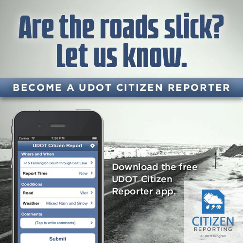
Utah's Citizen Reporter app allows trained volunteers to report road and weather conditions to the agency's traffic operations center. Credit: Utah Department of Transportation
The Indiana Department of Transportation (INDOT) buys real-time crowdsourced probe vehicle speed data on more than 2,000 interstate segments. This proved useful during the unplanned closure of a bridge on Interstate 65 between Indianapolis and Chicago that necessitated a 60-mile diversion route. Driving the detour took up to 4 hours on the first day.
Using its Traffic Ticker dashboard to process and visualize crowdsourced data, INDOT made operations changes that reduced detour driving time to 64 minutes, such as retiming traffic signals and adding temporary signals. "We used metrics to change operations and improve customer experience," said Edward Cox, engineering director of traffic management for INDOT.
Incident detection was one of the first uses of crowdsourcing for the Kentucky Transportation Cabinet (KYTC). The agency created a process that compares real-time probe vehicle data with crowdsourced reports from Waze, a community-based traffic and navigation app. When an incident is detected, an automated email goes to KYTC's traffic management centers. "The crowdsourced data add context to the probe data and help us understand what users are experiencing," said Chris Lambert, KYTC transportation data manager.
Crowdsourced data also help KYTC better understand incident response and clearance timelines when it conducts after-action reviews. "Maps are great for situational awareness, but they don't tell the entire story, such as when an event started or congestion increased," said Lambert. "Dashboarding our probe data along with crowdsourcing data allows us to drill down and see the order of events."
Watch a webinar on how agencies use crowdsourcing to proactively operate transportation systems.
Contact James Colyar or Paul Jodoin of the FHWA Office of Operations for information, technical assistance, and training, including workshops and peer exchanges.
Communication is critical to success in advancing new technologies and practices to meet the Nation's transportation needs, says Brandye Hendrickson, Federal Highway Administration deputy administrator.
"This is why the State Transportation Innovation Council (STIC) network is so important," Hendrickson told participants in a national STIC meeting webcast in April. "We're all ambassadors of innovation. We all have work to do in helping each other, our stakeholders, and the public understand that innovation has the potential to enhance safety, cut costs, shorten project delivery times, and save money for taxpayers."
By encouraging collaboration and communication among transportation partners in each State, the STIC network is a driving force for better project delivery, Hendrickson said. "You bring the best minds, best ideas, and best efforts together from the public and private sectors to determine what innovations will work best in your State," she said.
Established in 2012, the Pennsylvania STIC assembles stakeholders from 26 organizations to promote Every Day Counts and other innovations from State, national, and international sources.
"We've found that communication is key to advancing innovations," Danielle Klinger-Grumbine, Bureau of Innovations division chief for the Pennsylvania Department of Transportation (PennDOT), said during the STIC webcast. "We need to ensure that we are communicating about the right innovation at the right time to the right people."
The STIC's communication goals are to increase knowledge, gain acceptance, and dispel myths about innovation deployment among target audiences. "We need target audiences' buy-in and support to ensure successful deployment," said Klinger-Grumbine.
STIC communication tactics include infographics, interactive displays, and outreach events such as safety symposiums and demonstration days, as well as webinars, social media posts, and media events. The Pennsylvania STIC website provides an anchor for communication efforts, including the Innovation in Motion e-newsletter and interactive STIC Year-End Report.
High-friction surface treatment (HFST) is one communication success story. "Targeted communication efforts helped move the needle to institutionalize HFST in Pennsylvania," said Anja Walker, Pennsylvania STIC manager.
Beginning in 2014, the STIC and PennDOT created videos and infographics to show technical staff and industry partners how to apply HFST and the benefits of using the technology. They displayed an interactive car model at conferences to demonstrate how HFST increases roadway friction and enhances safety. They also invited local agencies to observe application of HFST and issued news releases to inform the public about HFST projects.
"We saw great results from these communication efforts," said Klinger-Grumbine. Since 2014, Pennsylvania agencies have applied HFST at 273 locations, compared to 42 locations from 2007 to 2014. Analysis of crash data from the 3 to 5 years after HFST installation at 47 locations found that fatal crashes dropped from eight to zero and injury crashes from 190 to 71.
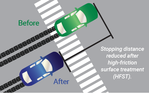
Credit: Pennsylvania DOT
FHWA Chief Innovation Officer Tony Furst discussed FHWA's new Accelerating Market Readiness (AMR) program to provide public agencies and private entities up to $3 million a year to spur transformative innovations from prototype to market.
"AMR opens the door to field-testing and evaluation of innovations that have completed the research phase," he said. "The reports on field-test outcomes will enable information sharing and communication across the STIC network." (See AMR overview on page 10.)
FHWA Center for Accelerating Innovation (CAI) Director Thomas Harman encouraged applications to the STIC Incentive program, which provides each STIC up to $100,000 a year to help standardize innovations, and provided examples of the types of efforts STIC Incentive funds can support.
"Develop a framework to determine where variable speed limits are warranted during weather events. Put together a safety plan to help reduce rural roadway departures. Use virtual reality technology to enhance project visualization and supplement public involvement," he said.
Communicating Strategically to Reach STIC Goals
Stakeholder engagement and communication help State Transportation Innovation Councils (STICs) thrive. The Center for Accelerating Innovation recommends considering these steps when developing a strategic communication plan:
Define objectives
Consider communication objectives that help accomplish STIC goals, such as improving member collaboration, raising transportation community awareness about innovations, or sparking public interest in innovation success stories.
Identify target audiences
For each objective, determine internal and external stakeholders to reach and consider their information needs and interests.
Fine-tune the message
Tailor messages to specific audiences and point out how they can benefit from an innovation.
Establish a communication calendar
Decide when and how frequently to communicate, which varies based on the objective, message, and audience.
Match the media to the audience
Consider demographics when choosing among options such as social media, online videos, email, webinars, and face-to-face meetings. Use multiple outlets for each audience to reinforce messages and increase impact.
To learn about communication's role in successful innovation, view the April 11 webcast at the national STIC meeting recordings page.
To get involved in the STIC network, contact your State STIC or Sara Lowry of CAI.
It can take years for transportation innovations to bridge the gap between research and widespread use. The Federal Highway Administration's new Accelerating Market Readiness (AMR) program funds real-world demonstrations and evaluations to move transformative innovations from prototype to practice faster.
"We're looking for technologies and processes that have already cleared the research hurdles and are ready for evaluation in a shared-risk environment," said Jeffrey Zaharewicz, senior advisor in FHWA's Center for Accelerating Innovation (CAI), which administers the AMR program.
AMR offers a total of $3 million a year for up to eight projects to conduct field tests and trial runs, collect and analyze performance data, and document the results. The program is open to State and local agencies, tribes, the academic community, and private industry. FHWA solicited applications for the program's first round through a Broad Agency Announcement in the spring.
"We'd like to advance ideas that are transformative, including those that have potential to significantly advance conventional practice or that fill a gap and advance the state of the art nationally," Zaharewicz said. "We're even interested in those that are considered disruptive, meaning they are game changers in the world of transportation."
AMR's first round focuses on innovations that support FHWA and U.S. Department of Transportation goals on safety, accelerated project delivery, and infrastructure performance. AMR projects can address technology and knowledge gaps to reduce transportation-related fatalities and serious injuries, shorten project delivery timeframes, decrease project life-cycle costs, and optimize the performance of transportation facilities.
FHWA, with the support of a peer review panel from the American Association of State Highway and Transportation Officials Innovation Initiative, is now evaluating the first round of AMR proposals. FHWA expects to announce awards in late 2019 to early 2020.
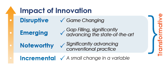
The AMR Program targets transformative innovations.
After AMR awardees complete their projects and document findings, FHWA will communicate the results through the State Transportation Innovation Council network and other stakeholder groups. "We're excited not only for the new ideas, but also for the opportunity to use our communication channels to share this information with the transportation community," said Zaharewicz.
By providing rapid assessment of emerging innovations and objective evaluation of results, FHWA expects AMR to feed the innovation deployment pipeline, including CAI's Every Day Counts program to accelerate adoption of proven but underused innovations.
AMR itself is a proven concept that builds on the success of FHWA's internal program to support advancement of technologies developed by agency researchers and program offices. An example is the pilot demonstration in 27 States of the Mobile Solution for Assessment and Reporting (MSAR), a mobile application and web portal that enable agencies to collect and share damage and survey reports in real time at a disaster scene. (See an Innovator article on how MSAR accelerates disaster recovery efforts.)
"As we looked at the successes of the internal AMR program, we felt we could augment them by engaging directly with State and local agencies, the academic community, and industry for their ideas and topics," said Zaharewicz. "We look forward to exploring the ideas that come to us and determining how we can best support those ideas."
FHWA plans to solicit another round of AMR proposals in 2020. Look for updates on the AMR web page.
Colorado Department of Transportation (CDOT) Region 4 saved more than $14 million using two-dimensional hydraulic models (2D) during design analyses in the past 3 years. CDOT applied 2D technology to more than 30 percent of the 95 projects supported by the Hydraulics Unit to develop a more detailed hydraulic analysis of bridges, culverts, and roadways than traditional one-dimensional analysis. The agency is now expanding statewide through an initiative to value-engineer projects at the planning and scoping stage of design construction to save $20 million a year. Building on past successes, CDOT's 2D initiative is expected to improve transportation safety, optimize public investment in infrastructure, and enhance the ecological performance of large bridges and culverts on Colorado highways by 2021.
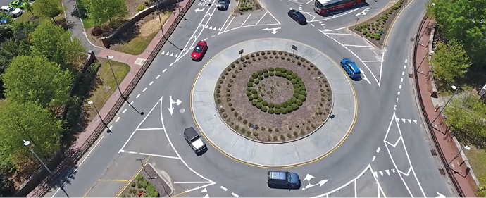
The North Carolina Department of Transportation (NCDOT) is using an informational video, captured in part by unmanned aerial systems, to educate the public and gain buy-in on its plan to use roundabout intersection designs. NCDOT reports that the video was critical in the public becoming comfortable with its proposed design. The bird's-eye perspective provided by drone footage helped those unfamiliar with roundabouts understand how they work and demonstrated the safety benefit offered by keeping traffic flowing. Transportation agencies use videos and other forms of virtual public involvement as an effective way to engage and educate the public about plans and projects.
During Every Day Counts round four, States achieved 82 percent of their goals to reach demonstration, assessment, or institutionalized implementation of featured innovations. "Every Day Counts: An Innovation Partnership With States" documents progress in accelerating the implementation of 11 innovations in 2017 and 2018 and success stories from States across the country.
Innovator, published by the FHWA Center for Accelerating Innovation, advances implementation of innovative technologies and accelerated project delivery methods in the highway industry. Its audience is transportation professionals in highway agencies, trade and research groups, academia and the private sector, and the driving public.
Elaine L. Chao, Secretary, U.S. DOT
Nicole R. Nason, Administrator, FHWA
Thomas Harman, Director
Jeffrey Zaharewicz, Senior Advisor
Ewa Flom, Program Coordinator
Sara Lowry, Program Coordinator
Fawn Thompson, Program Coordinator
Julie Zirlin, Program Manager
Nichole Causey, Marketing Specialist
Ellen Schweppe, Managing Editor
James Cline, Jr., Designer
Pat Holcombe, Designer
Rodney Walker, Designer
Email reprint requests to Nichole Causey
View Innovator archive.