U.S. Department of Transportation
Federal Highway Administration
1200 New Jersey Avenue, SE
Washington, DC 20590
202-366-4000
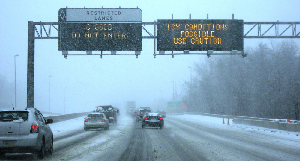
Transportation agencies are finding that combining Every Day Counts (EDC) innovations accelerates success. Pairing weather-responsive management strategies and crowdsourcing for operations, for example, creates synergies that leverage the impact of both innovations.
"A whole host of operational strategies can be enhanced with crowdsourced data," said Paul Jodoin, co-leader of the EDC team on crowdsourcing, which helps agencies increase situational awareness of real-time traffic conditions. A webinar explored how agencies in Wyoming, Utah, and Kentucky use mobile applications and crowdsourced data to improve traffic and maintenance management in inclement weather.
View a video on how to use the Wyoming 511 app.
The Wyoming Department of Transportation (WYDOT) developed the Road Condition Reporting app to share information between maintenance vehicles and its Traffic Management Center (TMC). The tablet-based app makes it easier for maintenance staff to report road and atmospheric conditions, variable speed limit suggestions, traffic incidents, and road hazards. Maintenance staff receive information such as road weather conditions and asset locations on the app, improving their situational awareness.
A same-storm comparison found that the number of road reports submitted doubled and variable speed limit change requests tripled with the app, compared to standard reporting by radio. "More reports equate to more accurate and timely information," said Vince Garcia, who manages WYDOT's geographic information systems/intelligent transportation systems program. "Our takeaway is that plow operators are more engaged with the app."
WYDOT also uses its Wyoming 511 mobile app to crowdsource data. In addition to providing real-time information on travel conditions, the app allows motorists to submit photos. "The TMC can use the image to update condition reports or share the image with the public, if appropriate,"said Ali Ragan, WYDOT project manager.
The Wyoming 511 app includes the capability to report truck parking availability at WYDOT locations, which is particularly important during weather-related road closures. "It helps truck drivers find a safe place to park," Ragan said.
The Utah Department of Transportation (UDOT) created a smartphone app to crowdsource data from motorists. Through its Citizen Reporter Program, UDOT enlists trained volunteers to use the app to report road and weather conditions on State highways. The data help UDOT fill in gaps where road weather information system data are not available and provide more timely and accurate road weather forecasts.
"The information also goes to our UDOT traffic app so travelers have a better idea of what to expect on the roadways," said Lisa Miller, UDOT traveler information manager. "The goal is to make sure people have the information they need to make informed and safe travel decisions."
In the 2018-2019 winter season, citizen reporters submitted 5,200 reports, up from 1,800 reports in the 2013-2014 season. UDOT estimates the program saves $250,000 a year because of the reduced need for road weather instrumentation and more efficient storm forecasting.
"We now have almost every segment of our roadway network assigned to a citizen reporter," said Miller. "We have many important rural routes that help with trucking traffic and vacation traffic going to ski resorts and parks, so this is a helpful way for us to get data."
The Kentucky Transportation Cabinet (KYTC) integrates data from third parties, such as Waze and Doppler radar, with agency sources, such as snowplows and roadway weather stations. "All of this flows into our system in real time, so our snow and ice personnel and TMC staff can mix and match the data to better understand a weather event," said Chris Lambert, KYTC transportation data manager.
KYTC uses some data on its GoKY website, which provides road condition and traffic information to travelers. Another application is the Snow and Ice Decision Support dashboard, which aggregates road weather data that KYTC shares with agencies such as the Kentucky State Police and Kentucky Emergency Management. "When agencies are talking about closing roads or creating detours, having a single understanding of what's happening on the roadway is useful," said Lambert.
The agency turned to crowdsourcing for road weather management when heavy rains led to flooding last year, using social media to ask Waze app users to submit reports on high-water locations. "The reports from people willing to participate in marking high-water locations nearly doubled between late February and early March," said Randi Feltner, KYTC snow and ice operations program manager.
As travelers in many States battle winter weather woes, the Every Day Counts round five (EDC-5) initiative on weather-responsive management strategies offers agencies tools to boost the effectiveness of traffic operations and highway maintenance during adverse conditions.
The initiative focuses on using road weather data from mobile and connected vehicle technologies to support proactive traffic and maintenance management strategies. "These strategies improve safety and mobility, reduce the environmental impact of maintenance materials, and decrease operational costs," said David Johnson, leader of the Federal Highway Administration's Road Weather and Work Zone Management team.
The strategies apply to more than snowy and icy roadways, Johnson emphasized. "Although winter weather operations are often thought of first, there are many other important applications," he said, such as flooding events, dust storms, and wildfires.
Working with the EDC-5 team, agencies in 16 States are developing implementation plans and learning more about weather-responsive management strategies. Nine States are demonstrating and assessing approaches to improve traffic operations and highway maintenance. Eleven States have institutionalized weather-responsive management strategies.
To aid deployment, the team created a weather-responsive management strategies toolkit, a one-stop shop for case studies, guidelines, webinars, and reports. This year, in addition to conducting workshops and peer exchanges, the team will continue its bimonthly webinar series. "These events will include early adopters who will provide insight for those looking to enhance their weather-responsive management strategies," Johnson said.
The Arizona Department of Transportation (ADOT) implemented a dust detection and warning system on a 10-mile stretch of Interstate 10 to quickly tell drivers to reduce speed for safety. The system includes sensors, overhead message boards, variable speed limit signs, and closed-circuit cameras in an area prone to sudden, localized dust storms that diminish visibility.
The system automatically activates variable speed limits when and where needed, lowering speed limits in 10 mile-per-hour increments to as slow as 35 miles per hour. Electronic message boards alert drivers to blowing dust, while ADOT traffic operators use overhead message boards on the way to the dust detection zone to warn drivers of potentially hazardous conditions ahead.
Closed-circuit cameras allow ADOT Traffic Operations Center staff to see real-time conditions on the roadway, while in-pavement sensors report the speed and flow of traffic. The system includes weather radar mounted on a 20-foot tower that can detect storms more than 40 miles away. This radar complements sensors mounted on posts next to the freeway that use light beams to determine the density of dust particles in the air.
In addition to enhancing safety by providing earlier warnings about blowing dust, this innovative system is expected to advance ADOT's understanding of whether similar technology can be effective in other locations around Arizona.
The Minnesota Department of Transportation (MnDOT) was an early adopter of integrating mobile observation (IMO), which involves instrumenting vehicles with road weather sensors and other automated technologies to acquire data to support decision making. MnDOT plow trucks, supervisor vehicles, and mower tractors collect data such as air and surface temperature, relative humidity, and wiper and brake status. Plow trucks also capture camera images of the road ahead.
Data from mobile and connected vehicle technologies support traffic management strategies such as posting road condition information during adverse weather.
By delivering data on traffic conditions beyond the limits of fixed sensors and cameras, crowdsourcing expands geographic coverage, improves information quality and timeliness, and enhances transportation operations strategies.
"With crowdsourcing, transportation agencies can get real-time information whenever and wherever people travel," said James Colyar, Federal Highway Administration transportation specialist and co-leader of the Every Day Counts round five (EDC-5) team on crowdsourcing for operations. "This enables agencies to more effectively and proactively operate their transportation system."
Crowdsourced data are also more cost-effective than traditional systems with their high up-front and ongoing maintenance costs. Data can be extracted from social media platforms, acquired from third-party data providers, and collected from agency-developed mobile applications.
The EDC-5 team is helping more than 30 States advance transportation operations with crowdsourced data. Assistance includes webinars, workshops, in-person and virtual peer exchanges, one-on-one technical support, and resources on the crowdsourcing for operations website such as sample crowdsourcing applications and frequently asked questions.
In 2020, the team will continue its "Adventures in Crowdsourcing" webinar series, starting with a January session on data management and governance. Spring peer exchanges will focus on crowdsourced probe vehicle data and data quality assessment and filtering. "These are excellent opportunities to learn from peers and experts," Colyar said.
Also available is an in-person workshop tailored to State and local agency needs that highlights the scope of crowdsourcing for transportation operations. The workshop debuted in 2019 in Honolulu, HI, and Cleveland, OH.
"The Hawaii workshop helped the Hawaii Department of Transportation recognize the value that can be derived from a specific data provider, and the agency is now pursuing its use," said Colyar. "The Ohio workshop not only made participants aware of new data sources, but helped them learn that their State DOT subscribes to probe vehicle data that local entities can access."
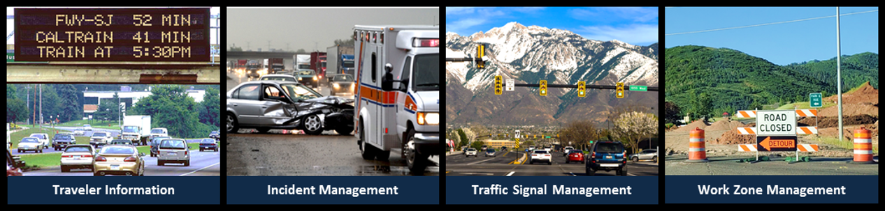
Agencies use a range of crowdsourcing applications to improve transportation systems management and operations:
Traveler information: The Pennsylvania Department of Transportation uses both crowdsourced and traditional data sources to populate its 511PA traveler information website. These data also power an emergency text alerting system, 511PA Connect, for traffic delays longer than 4 hours. Crowdsourced data improve the speed, coverage, and reliability of both information tools.
Incident management: The Florida Department of Transportation (FDOT) combines data from a community-based traffic and navigation application with computer-aided dispatch (CAD) system data to improve the response time for crashes and unplanned road closures. The app data are imported directly into FDOT's advanced traffic management system, where they are integrated with CAD incident reports for analysis.
Crowdsourcing turns transportation system users into real-time traffic sensors, providing agencies with data for roadway management activities.
Traffic Signal Management: By buying crowdsourced data from an outside source, the city of Austin, TX, was able to implement a data-driven signal retiming strategy to replace a cyclical one. In the past, the city timed signalized corridors on a 3-year rotation and measured retiming results using floating vehicle travel time runs. Using crowdsourced data required no infrastructure investment and fewer labor costs, allowing Austin to allocate signal retiming resources based on need and improve corridor performance.
Work zone management: Using third-party probe data, the Indiana Department of Transportation (INDOT) can analyze detour routes to ensure optimal traffic flow. One incident involved a 37-mile road closure on Interstate 65, during which a 62-mile detour route was identified, selected, and monitored using the data. Driving the detour took up to 4 hours the first day, but using its Traffic Ticker dashboard to process the data enabled INDOT to make operational changes that cut driving time to 64 minutes.
Performance monitoring and reporting: INDOT collects raw data on vehicle speeds from crowdsourced Global Positioning System services. The agency processes the data for a dozen mobility dashboards that report congestion profiles, travel delays, and speed maps for road segments. The dashboards support a variety of analyses, including ranking of road segments by performance.
Maintenance: The Delaware Department of Transportation (DelDOT) created a traveler information app with a "report an issue" feature that allows travelers to report potholes, streetlight outages, and other roadway conditions. DelDOT shares relevant reports with each district weekly to inform plans for repair of potholes or other issues.
Sharing expertise through the national State Transportation Innovation Council (STIC) network and other peer venues is integral to successful innovation, says Federal Highway Administration Executive Director Thomas Everett.
"Many innovations STICs deploy come from programs such as Every Day Counts (EDC), but others come from collaborating with peers about challenges and new ideas," Everett told participants in a national STIC webcast in October 2019. "It's well known that peers learn best from peers and DOTs listen to other DOTs. Peer exchanges, demonstrations of tools and techniques, and communities of practice are effective ways of sharing information."
Everett cited a Local Innovation Implementation Summit the Colorado Local Technical Assistance Program organized with the help of STIC Incentive funds. The summit featured hands-on demonstrations and promoted an equipment loan program to support innovation deployment, such as traffic counters for data-driven safety analysis. "Now more local agencies are using this loan program to deploy innovations," said Everett.
Colorado's program echoes FHWA Mobile Asphalt Technology Center and Mobile Concrete Technology Center trailers that travel to States to provide equipment loans, demonstrations, and training on pavement technologies. "We've found that this is an effective way to help agencies apply new tools and techniques," Everett said.
What do transportation agencies say they need to expedite innovation?
"A common theme is that we need to continue to look at removing government hurdles to innovation," said Everett, such as a Federal rule repealing restrictions on the use of patented or proprietary technology on Federal-aid highway projects. The rule empowers States to choose the materials, tools, and products that best meet their needs.
Sharing information on research is also important, said Thomas Harman, director of FHWA's Center for Accelerating Innovation (CAI). "We need to manage research as a valuable asset," he said. "One thing we can do better is tell the research story. That's the pipeline to innovation."
How can agencies sustain a culture of innovation?
"It starts at the top. You need leadership support to succeed," said Everett. "You also have to show a willingness to accept risk and even failure. We will never sacrifice safety, but we need to convey that it is okay to try things that might not work out."
Many innovators are just trying to solve the problem in front of them. "People don't necessarily label themselves as innovators, but often what they think is not an innovation is visionary," Harman said. "Again, communication is key."
What are successful ways to deploy research?
"You first need to communicate the research results," said Everett. "You then need to demonstrate application of the innovation and communicate the results of that demonstration. You also need an innovation champion to keep momentum going."
Another good practice is engaging potential adopters early. "A key to successful research is having end users involved to help guide it," Harman said.
How can I determine if the Accelerating Market Research (AMR) program is right for my innovation?
The AMR program offers up to $3 million a year to fund demonstrations and evaluations to move transformative innovations from prototype to practice faster. "We're looking for technologies and processes that have cleared the research hurdles and are ready for evaluation in a real-world setting," said Jeffrey Zaharewicz, CAI senior advisor.
A good frame of reference is an innovation's Technology Readiness Level, an assessment of maturity on a one-to-nine scale from research to implementation. "A potential candidate would be at the five or six level on the scale that with AMR resources might achieve a market-ready level," said Zaharewicz. FHWA plans to solicit a new round of AMR proposals in 2020.
How can I learn how other States use STIC Incentive funds?
The STIC network website provides guidance on the STIC Incentive program to support the cost of standardizing innovative practices and State details on projects. "You can also talk to your State EDC coordinator," said Sara Lowry, CAI program coordinator.
Lowry encourages STICs to look for inspiration on websites created by fellow STICs, such as those in Alaska, Arizona, Colorado, Michigan, New Jersey, New Mexico, New York, North Dakota, Pennsylvania, Texas, Vermont, and Wisconsin.
What are "graduated" innovations?
Some innovations from past EDC cycles, such as warm-mix asphalt and accelerated bridge construction, have advanced to mainstream use and graduated from consideration for the Accelerated Innovation Deployment (AID) Demonstration program, which awards funding up to $1 million for projects that use proven innovations.
Some graduated innovations, such as e-Construction and intelligent compaction, remain eligible for AID Demonstration funding on local and tribal projects. "We recognize it can take longer for innovations to penetrate to the local level," Harman said. The innovation eligibility change is included in the revised AID Demonstration Notice of Funding Opportunity.
As use of accelerated bridge construction (ABC) technologies expands, transportation agencies are exploring implementation of ABC in seismic regions. Devising connections between prefabricated bridge elements that can withstand earthquake loading is a primary challenge.
"We want connections that are constructible, are seismic resilient, and have long-term performance and longevity," Bijan Khaleghi, State bridge design engineer for the Washington State Department of Transportation, told participants in an Accelerated Bridge Construction-University Transportation Center (ABC-UTC) webinar on ABC in seismic regions. "A seismic event is an extreme event that doesn't happen every day, but we need to be ready for it."

The American Association of State Highway and Transportation Officials' (AASHTO) new LRFD Guide Specifications for Accelerated Bridge Construction includes information on seismic design for ABC. Section 3.4 covers recommended seismic analysis and design methods and seismic systems and elements. It also discusses several connection types, including mechanical bar connectors, grouted duct connections, pocket connections, socket connections, and two-stage integral pier caps.
The aim of the ABC guide specifications is to ensure minimal bridge damage under moderate earthquakes and collapse prevention under rare, more severe earthquakes, said Lee Marsh, deputy director of America's Technical Excellence Center at WSP. The specifications were developed to work in tandem with AASHTO's LRFD Bridge Design Specifications.
"These guide specifications are expected to change as we incorporate ongoing seismic research," said Marsh. "There are a lot of innovative ideas coming out, so we'll see updates to capture future research."
Marsh used a chain analogy to explain the fundamental concept of ABC seismic design. "A chain is no stronger than its weakest link," said Marsh. "If the weakest link is a ductile link, the entire system will be ductile in the way it performs. If the weakest link is brittle or nonductile, the entire system will look brittle in terms of its performance. So it's important for the designer to determine what the weak link is and make that link a ductile one."
Watch the ABC-UTC webinar for an overview of the latest information on research and implementation of ABC in seismic regions, including an introduction to Section 3.4 on seismic design for ABC in the LRFD Guide Specifications for Accelerated Bridge Construction.
Consult National Cooperative Highway Research Program report 242 on Recommended AASHTO Guide Specifications for ABC Design and Construction for background to help engineers apply the guide specifications.
Contact Romeo Garcia of the Federal Highway Administration Office of Infrastructure or Jamal Elkaissi of the FHWA Resource Center for information and technical assistance on ABC.
The Pennsylvania Department of Transportation (PennDOT) saved an estimated $39 million in overall productivity through its mobile construction application program, part of its e-Construction implementation. PennDOT based its calculations on time saved using apps compared to older paper and manual processes. PennDOT's goals include increasing field staff productivity, transforming labor-intensive paper processes through efficient mobile technology, and improving data collection and reporting capabilities. After implementing its first app in 2013, PennDOT now uses nine apps and has another two in development. The apps include mobile construction documents, punch lists, concrete inspection diaries, mileage and hour trackers, and payroll.
The Vermont Agency of Transportation (VTrans) is realizing benefits from its deployment of automated traffic signal performance measures (ATSPMs). VTrans can now monitor and count traffic in intersections with ATSPMs 24 hours a day, compared to past manual data collection every 1 to 2 years. This heightened monitoring allows the agency to get reports and deploy traffic signal staff proactively rather than react to calls from the public. In one case, VTrans received a complaint about a malfunctioning pedestrian light at an intersection 120 miles from headquarters. After installing ATSPMs, VTrans was able to review data and determine that the pedestrian push button was failing randomly, which was not evident during field observation.
As part of its safe transportation for every pedestrian (STEP) implementation, the District Department of Transportation (DDOT) in Washington, DC, deployed more than 580 leading pedestrian intervals (LPIs), which allow pedestrians to walk before vehicles get a green signal to turn. Under its Citywide Signal Optimization program, DDOT developed selection guidelines and criteria to evaluate intersections for LPI implementation. The guidelines capture the magnitude and severity of pedestrian-vehicle interactions at signalized intersections and identify locations with physical characteristics that make those interactions more dangerous. The data used to drive these decisions include crash data, pedestrian and vehicle volume counts, land use, and visual inspection of sight line obstructions and crosswalk locations.
Visit booth #921 at the Transportation Research Board Annual Meeting—January 12 to 16 in Washington, DC—to learn about the Center for Accelerating Innovation and the 10 innovations in Every Day Counts (EDC) round five. Booth #924 will highlight how the Office of Innovative Program Delivery advances innovation in the transportation community.
The "Federal Highway Administration Leadership in Innovation" session—#1203 at 10:15 a.m. on January 13—will highlight the importance of moving research results into practice. Speakers will cover how to monitor research on the continuum from idea to deployable result, establish pathways to test innovations operationally and deploy proven innovations, and ensure that the research-to-practice process includes development of innovation deployment skills.
See a list of EDC-related exhibits and sessions to plan your meeting schedule.
Innovator, published by the FHWA Center for Accelerating Innovation, advances implementation of innovative technologies and accelerated project delivery methods in the highway industry. Its audience is transportation professionals in highway agencies, trade and research groups, academia and the private sector, and the driving public.
Elaine L. Chao, Secretary, U.S. DOT
Nicole R. Nason, Administrator, FHWA
Thomas Harman, Director
Jeffrey Zaharewicz, Senior Advisor
Sara Lowry, Program Coordinator
Fawn Thompson, Program Coordinator
Julie Zirlin, Program Manager
Nichole Causey, Marketing Specialist
Ellen Schweppe, Managing Editor
James Cline, Jr., Designer
Pat Holcombe, Designer
Rodney Walker, Designer
Email reprint requests to Nichole Causey
View Innovator archive.

