U.S. Department of Transportation
Federal Highway Administration
1200 New Jersey Avenue, SE
Washington, DC 20590
202-366-4000
Effective public engagement during transportation planning and project development can boost collaboration and accelerate project delivery. Adding virtual public involvement techniques extends the reach of engagement strategies by making stakeholder participation more convenient, affordable, and even enjoyable.
"As transportation professionals, we can no longer expect the public to come to us," said Scott Allen, Federal Highway Administration transportation specialist and co-leader of the Every Day Counts round five (EDC-5) team on virtual public involvement. "We need to reach people in their everyday lives, whether online, at home, or in a chosen gathering space."
In EDC-5, agencies are learning how to supplement face-to-face information sharing with virtual tools, such as mobile applications, project visualizations, and virtual town halls. "These innovative approaches are not intended to replace traditional public involvement, but to enhance existing strategies and broaden our reach to ensure that all voices are heard," said Allen.
The team is working with State transportation departments, metropolitan planning organizations, and local agencies to plan workshops and peer exchanges to share best practices. This summer, the team will kick off an "Expanding Our Impact" series of videos and factsheets on virtual public involvement tools and strategies, following its 2019 "Extending Our Reach" series.
With the team's assistance, 23 States are demonstrating and assessing virtual strategies to engage the public. Eight States institutionalized virtual public involvement techniques and use them regularly for planning and project development, including Colorado, Florida, Iowa, North Carolina, Ohio, Texas, Vermont, and Washington.
The Colorado Department of Transportation (CDOT) hosted telephone town halls to gather input for its statewide long-range transportation plan update. CDOT held 15 telephone town halls—10 in rural transportation planning areas and five in metropolitan areas—to hear about each area's needs and priorities.
Moderators asked questions such as "how should CDOT invest limited funding?" to address issues such as safety, maintenance, and operation of existing facilities; freight movement; bus service; and active transportation options. Participants were able to ask the moderators questions, make comments, and participate in live polls using touch-tone phones.
The results informed priorities for the plan and provided feedback for other CDOT planning documents, including transit, bicycle/pedestrian, and safety plans. CDOT continues to use this method to report on progress in implementing the plan. Nearly 58,000 people participated in the sessions, including more than 17,000 in rural regions.
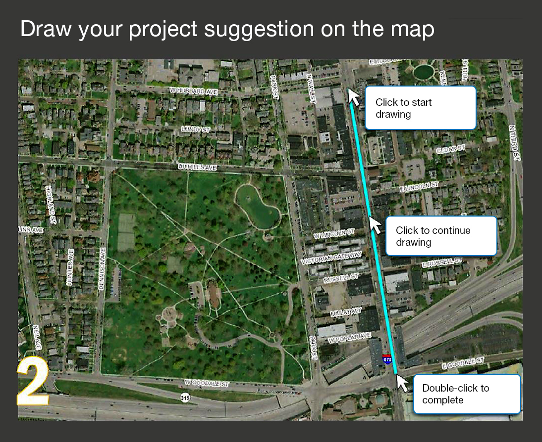
The Mid-Ohio Regional Planning Commission encouraged the public to offer project ideas by drawing on its interactive map. Photo Credit: Mid-Ohio Regional Planning Commission
The Mid-Ohio Regional Planning Commission (MORPC) developed an interactive map for its metropolitan transportation plan. When MORPC asked people to draw project ideas on the map, it received more than 300 suggestions. After screening to ensure each was suitable for consideration in the planning process, MORPC displayed the suggestions for comment, along with other candidate projects identified in State and local planning processes. More than 700 people added comments, which were visible to everyone who viewed the map.
MORPC publicized the map through social media, emails, and meetings, encouraging people to share the link with others. "We received more than 10 times the number of comments and interactions than we did using traditional methods," said Maria Schaper of MORPC. "This interactive map has become a key tool for telling the transportation story in central Ohio."
Mobile applications allow users to get information or submit their own text and images. An app can serve as a digital clearinghouse for project planning and development, public involvement opportunities, and contact information.
Project visualization techniques include photo simulations, three-dimensional images, videos, aerial footage, and augmented reality, providing a mockup of what a proposed project would look like.
Do-it-yourself videos shot with tablets, smartphones, and digital cameras are an affordable and accessible way to reach stakeholders with content about plans, projects, and events.
Digital crowdsourcing tools gather suggestions and provide a forum for others to weigh in on ideas. They enable stakeholders to engage in the early stages of a project in a quick, easy way.
Virtual town halls offer a way to take part in transportation planning without traveling to a meeting location. Participants can join the meeting via teleconference or online meeting software.
Mapping tools communicate information in a visual format. Their interactive capabilities allow users to search, click, and query their way across a project site, neighborhood, or region to gather details not easily accessible in other formats.
All-in-one tools combine crowdsourcing features, mapping, visualization, file sharing, and survey instruments, offering a one-stop-shop for information on a topic.
Digital tools to enhance in-person events include live polling via mobile devices, collecting and sharing ideas with tablets, and using social media to stream public meetings in real time.
View an Innovation Spotlight video on how virtual public involvement techniques enhance transportation planning and project development.
Visit the FHWA virtual public involvement web page for case study videos, factsheets, and webinars.
Contact Scott Allen or Carolyn Nelson of the FHWA Office of Planning, Environment, and Realty for information and technical assistance.
When transportation agencies use unmanned aerial systems (UAS), they elevate their ability to collect accurate data rapidly and access hard-to-reach locations safely and cost-efficiently. While UAS are useful in many areas of highway transportation, in Every Day Counts round five (EDC-5) the Federal Highway Administration is focusing on helping agencies deploy drones for construction inspection, structural inspection, and emergency response.
Using UAS for construction inspection enables inspectors to capture a bird's-eye view of a project's progress while saving time and money and increasing productivity. Structural inspection with UAS enhances safety for the inspection team and traveling public by reducing the need for work zones. UAS also help agencies respond to and assess damage from emergencies faster and obtain quality data to make more informed decisions.
View a video on how the New Jersey Department of Transportation deploys UAS to increase safety and accuracy, accelerate data collection, and provide access to challenging locations.
To encourage deployment, the EDC-5 team is organizing workshops for State transportation departments that feature experts on UAS use cases of interest to the agencies. "These are popular because States can engage large numbers of staff and even local agencies they work with," said James Gray, FHWA UAS and construction technology engineer and co-leader of the EDC-5 team. "We also plan peer exchanges between States with UAS programs to facilitate sharing of best practices and details on operations that might be new to one of the participating States."
Eight States have institutionalized the use of UAS so far in EDC-5. They include the Utah Department of Transportation (UDOT), which deploys UAS for traffic incident management, mapping and surveying, bridge inspection, and construction administration. The New Jersey Department of Transportation, which received State Transportation Innovation Council Incentive funds to help institutionalize its UAS program, has used drones to obtain project management photos and videos, conduct a preconstruction survey of a rail line crossing, and aid response after a rockslide.
The Minnesota Department of Transportation (MnDOT) was an early adopter of integrating mobile observation (IMO), which involves instrumenting vehicles with road weather sensors and other automated technologies to acquire data to support decision making. MnDOT plow trucks, supervisor vehicles, and mower tractors collect data such as air and surface temperature, relative humidity, and wiper and brake status. Plow trucks also capture camera images of the road ahead.
A 2019 survey by the American Association of State Highway and Transportation Officials (AASHTO) found that 49 States use UAS technologies in some way and 36 States have hired UAS-related staff, including pilots and drone operations managers. The survey documented the top five UAS missions:
When AASHTO conducted its first UAS survey in 2016, no State transportation department had incorporated UAS into daily operations. "In 3 short years, we've gone from zero to 36 State DOTs executing drone missions internally," said Jim Tymon, AASHTO executive director. "This giant leap is helping States work safer, smarter, and faster than ever before, and that adds up to big savings for taxpayers and improved safety for motorists."
Twenty-nine States reported in the AASHTO survey that UAS help them save money. The Colorado Department of Transportation (CDOT) uses UAS to map geohazards such as rockfalls and landslides in more than 40 mountainous corridors. This cost-efficient way of capturing images remotely saves the agency 40 percent over traditional methods. "We're able to capture large amounts of data in an entire corridor in a short amount of time," said Ty Ortiz, CDOT geohazards program manager. "All that data helps us understand where and how to mitigate those geological hazards."
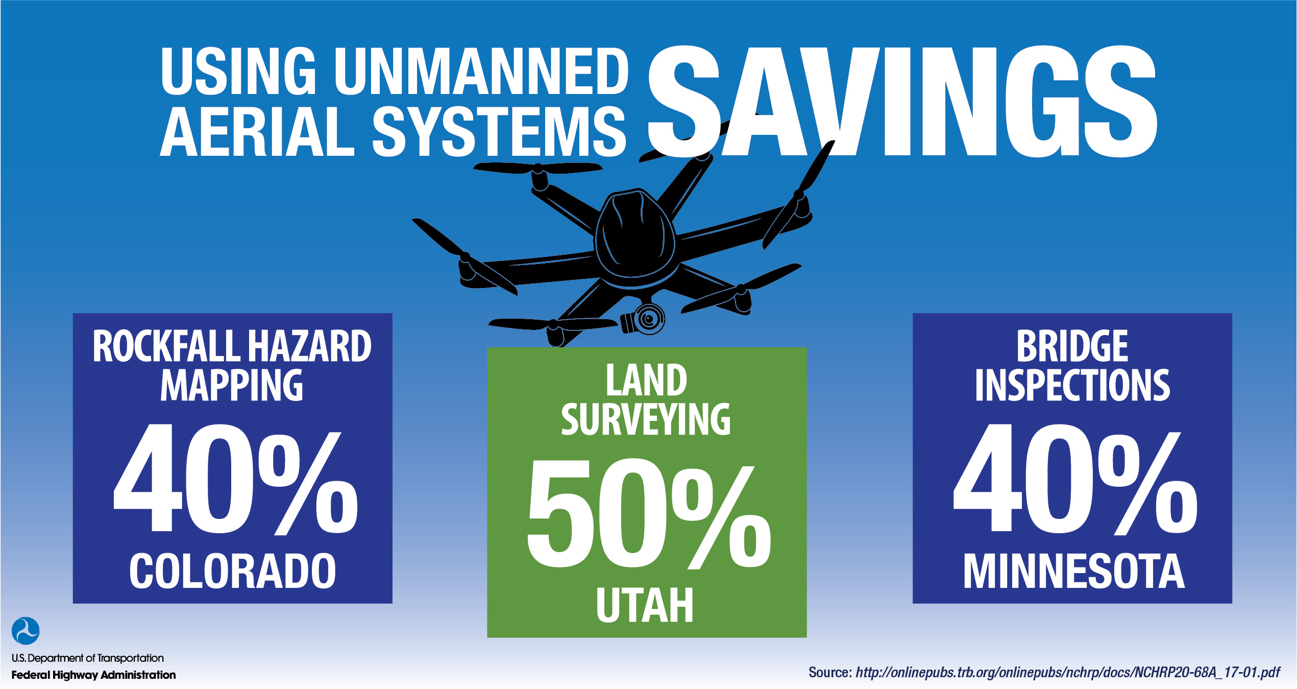
Unmanned Aerial Systems Savings
UDOT estimates that using UAS can reduce surveying time by as much as 50 percent while improving safety. "We did a job in Moab, where we've got 500- and 1,000-foot high cliffs, and trying to get a guy up on those cliffs is nearly impossible," said Paul Wheeler, UDOT UAS program manager. "We were able to fly that and get that data, then supplement it with LiDAR on the roadway and combine the two." Obtaining and processing the data took about 2 weeks, compared to a month with traditional surveying methods.
Since adopting UAS, the Minnesota Department of Transportation (MnDOT) reports average cost savings of 40 percent over traditional bridge inspection methods. Supplementing hands-on inspections with UAS also helps MnDOT improve data quality, especially for difficult-to-access bridge elements such as confined spaces, high wall abutments, steep slopes, and piers under traffic. UAS deliver infrared and three-dimensional modeling detail of bridges, identify concrete delamination, and gather topographic mapping detail.
View an Innovation Spotlight video on how agencies use UAS in transportation applications.
Read TechBriefs to learn about the use of UAS in construction inspection, bridge inspection, emergency management of flooding, and land surveying.
Visit FHWA's UAS web page for State policies, research reports, and webinars on UAS.
Contact James Gray of the FHWA Office of Infrastructure or John Haynes of the FHWA Utah Division for information, technical assistance, and training.
Unmanned Aerial System Videos Enhance Virtual Public Involvement Techniques. Videos and other virtual public involvement techniques are effective ways to draw people into transportation planning and project development processes. Using unmanned aerial systems (UAS) to capture video footage enhances agency efforts to tell compelling visual stories and garner public support for infrastructure improvements.
The Washington State Department of Transportation's Visual Engineering Resource Group (VERG), which helps the agency communicate about infrastructure projects through visual media, uses aerial video in many of its products. WSDOT credits UAS with reducing lead time and cost on video production.
"UAS are the way to go for aerial visual acquisition," said Kurt Stiles, VERG manager. The price of a UAS system can be similar to the cost of a few hours of helicopter rental, and the UAS provides years of service. VERG uses UAS to recreate cinematic shots and effects in its visual storytelling of a project.
To support public involvement for one of the most complex projects in WSDOT's history, VERG used drones to capture footage of key stages of the Alaskan Way Viaduct replacement. The project included replacing the viaduct, an elevated section of State Route 99 in Seattle, with a 2-mile-long tunnel under the city, removing a seismically vulnerable structure from the road network and clearing the way for new public space on the downtown waterfront.
The Washington State Department of Transportation flew a drone through the SR 99 tunnel to record construction progress. To avoid disrupting crews, the video was recorded between regular work shifts. Credit: Washington State Department of Transportation
The agency used UAS footage to provide updates through web links, public meetings, and social media, including its online video channel. One video, "View from a drone inside the SR 99 tunnel," takes viewers on a 4-minute tour of the tunnel under construction, showing where a tunnel-boring machine installed the curved concrete segments that make up the tunnel walls and crews built the double-deck road inside the circle. The video of the tunnel, which opened to traffic in 2019, received nearly 250,000 online views.
From planning and communication to design and construction, VERG products such as videos are vital to project success, said Stiles. "With virtual public involvement and conducting your visual communication effort virtually, you will win," said Stiles. "You will find a lot more yeses. You will gain a lot more consent. At the end of the day, if you're saving time, you're saving money, and our infrastructure and our public deserve it."
The North Carolina Department of Transportation (NCDOT) used an informational video, captured in part by UAS, to educate the public and gain buy-in on its plan to use roundabout intersection designs to enhance safety and reduce congestion. NCDOT reports that the video was critical in helping the public become comfortable with the design concept and changing the minds of some who did not like the idea of using roundabouts. The bird's-eye perspective of the drone footage helped those unfamiliar with roundabouts understand how they work and demonstrated the safety benefit offered by keeping traffic flowing.
The North Carolina Department of Transportation used UAS to create a video to educate the public about the benefits of roundabouts. Credit: North Carolina Department of Transportation
Contact Scott Allen or Carolyn Nelson of the Federal Highway Administration Office of Planning, Environment, and Realty for information on virtual public involvement.
Contact James Gray of the FHWA Office of Infrastructure or John Haynes of the FHWA Utah Division for information on UAS.
Incorporating a new technology into how the transportation community conducts business is a multifaceted challenge. "Incorporating innovation can be disruptive," said Thomas Harman, director of the Federal Highway Administration Center for Accelerating Innovation (CAI). "Bringing innovations from research to practice takes champions and an understanding of the complexity of the transportation market."
At a Transportation Research Board annual meeting session in January, speakers discussed how to evaluate innovations worth pursuing and move them from research into the field. FHWA Chief Innovation Officer Tony Furst said the process begins by answering key questions: "Does the research address an identified need? Has the research advanced enough to work in the field? Do we have the means to make it readily available? Can the workforce absorb the innovation into how it does business?"
Innovations move along a pathway from initial concept to widespread use. FHWA uses the technology readiness level (TRL) scale, created by the National Aeronautics and Space Administration, to describe the nine steps an innovation undergoes from concept to deployable resource. "This tool ensures we are advancing innovations that actually have legs," said Jeffrey Zaharewicz, CAI senior advisor. "It provides a basis for navigating the often-confusing progression research to practice takes."
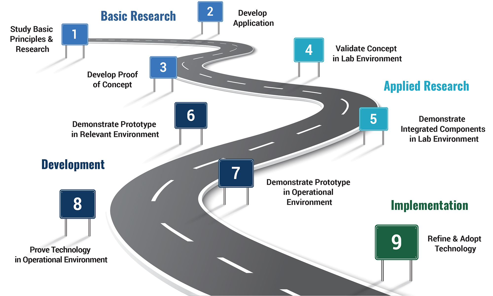
The TRL scale provides a way to interpret an innovation's progress, but it does not quantify the difficulty of advancing the innovation to a higher readiness level, address return on investment, or describe market demand. FHWA's "TRL Guidebook" explains the TRL assessment process.
Not all research makes it into practice. "As a matter of fact, most does not," said Harman. "But for innovations that are high value, how do we help them along this TRL pathway?"
The Exploratory Advanced Research Program administered by the FHWA Turner-Fairbank Highway Research Center (TFHRC) focuses on high-risk, high-reward research that bridges the gap between basic and applied research—innovations at TRLs one through five. CAI supports advancement of innovations at higher TRLs through its Accelerating Market Readiness (AMR), State Transportation Innovation Council (STIC) Incentive, Accelerated Innovation Deployment (AID) Demonstration, and Every Day Counts (EDC) programs.
The AMR program advances innovations at a TRL of five or six to seven or higher. AMR innovations are potential game changers that can save lives, accelerate project delivery, and make infrastructure last longer. AMR funding is available to test innovations in real-world settings, document results, and advance them along the TRL pathway. For example, TFHRC developed an in situ scour testing device using AMR funding. Attached to a rig in the field, the erosion head determines soil erodibility, the leading cause of bridge failures.
The STIC Incentive program accelerates implementation of innovations at TRLs seven to nine by offering up to $100,000 per STIC per year to support the cost of standardizing innovative practices. The New Jersey Department of Transportation (NJDOT) used STIC Incentive funds to develop its unmanned aerial system (UAS) program. Now, NJDOT uses UAS to increase accuracy, speed up data collection, and provide access to hard-to-reach locations.
The AID Demonstration program provides up to $1 million to use innovation on a project. FHWA has awarded more than $74 million for 102 projects to use innovations at TRLs seven to nine. In one project, the Missouri Department of Transportation (MoDOT) rehabilitated a bridge with a nanocoating product that forms a passive corrosion protection system. Using the innovation allowed MoDOT to accelerate construction, reduce traffic delays, and provide a longer-lasting coating system on the bridge.
EDC is a State- and local-based program that rapidly deploys proven but underused innovations at TRL nine. EDC has promoted 52 innovations since 2011. Every State has advanced at least 19 EDC innovations, and some have deployed more than 40.
While FHWA and other agencies work to adopt innovations, the transportation workforce needs to develop the skills to deploy those innovations. "The workforce is aging, many are retiring, and the system is not attracting enough new workers," said Karen Bobo, director of FHWA's Center for Workforce Development.
Identifying new skills needed to deploy innovations and ensuring that training is available to blend them into existing skills is an ongoing challenge. FHWA is creating partnerships with academia, industry, and government agencies to address this challenge. In one partnership, FHWA collaborated with the American Association of State Highway Transportation Officials, Associated General Contractors, American Road & Transportation Builders Association, and U.S. Department of Labor on best practices, outlined in a playbook, to identify, train, and place highway construction workers.
Research investments create long-term improvements taxpayers can see and stretch limited transportation funds. TRLs help agencies assess innovation readiness, apply for funding, and create a return on investment that benefits the traveling public.
To get involved in the STIC network, contact your State STIC or Sara Lowry of CAI.
Innovations help agencies create a safer transportation system for travelers. Winners of the 2019 National Roadway Safety Awards applied Every Day Counts innovations such as median U-turn intersections and high-friction surface treatments (HFST) to reduce crashes and save lives.
Sponsored by the Federal Highway Administration and Roadway Safety Foundation, the competition honors successful approaches to improving roadway safety. "We commend the winners for their success not only in saving lives on our Nation's roads, but also for maximizing the cost-effectiveness of Federal, State, and local funds that were used," said FHWA Executive Director Tom Everett.
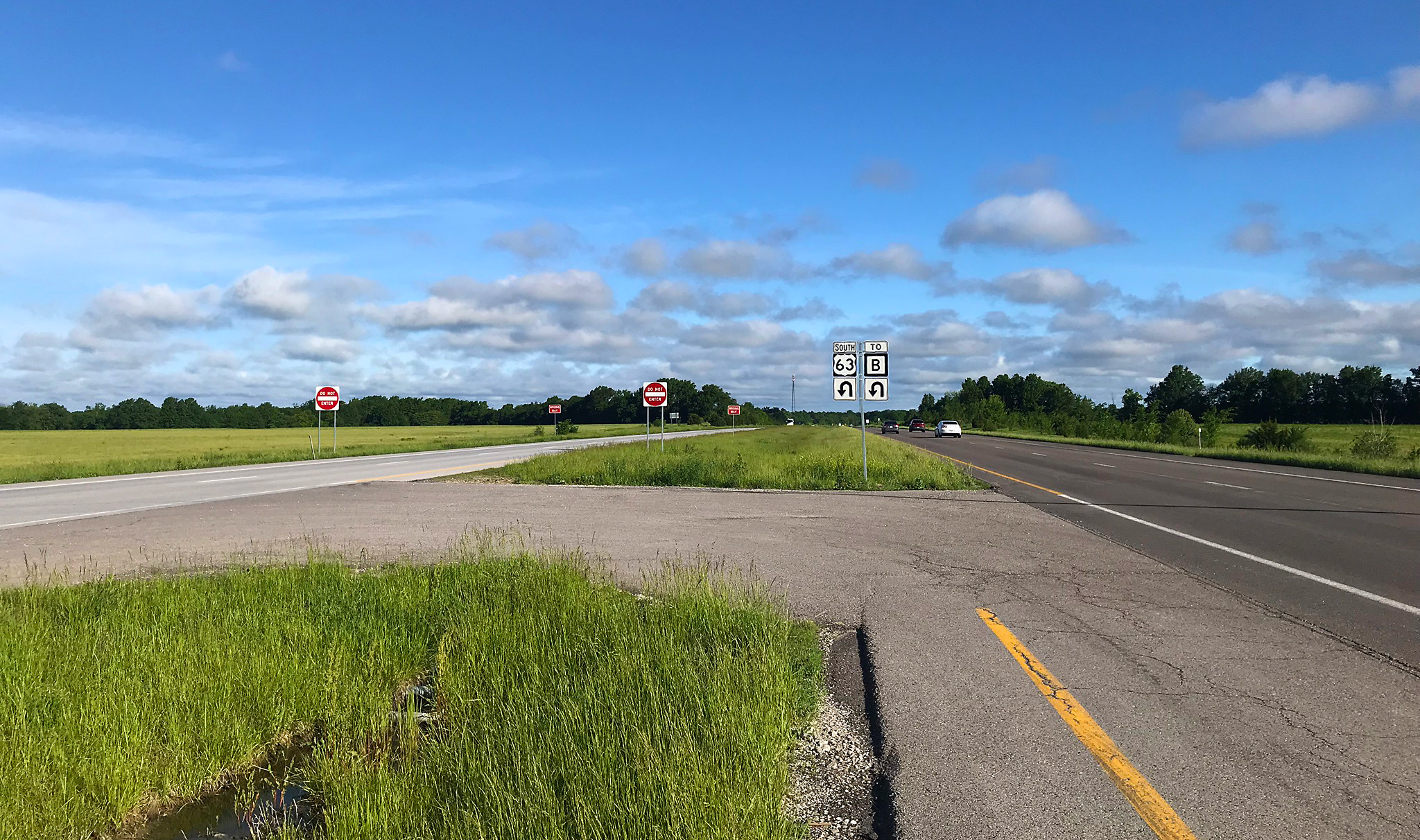
The Missouri Department of Transportation constructed a median U-turn to eliminate right-angle crashes at the intersection of U.S. 63 and Routes B/P in Clark. Credit: Missouri Department of Transportation
A multidisciplinary team conducting a road safety audit (RSA) identified three at-grade intersections on U.S. 63 in central Missouri for improvements because of a history of four fatal and eight severe-injury crashes. At all three locations, the Missouri Department of Transportation (MoDOT) constructed median U-turn intersections, which improve safety by eliminating side road crossing and left-turn movements at intersections on four-lane expressways.
An extensive public involvement campaign educated stakeholders on the need for safety improvements and the benefits of the median U-turn concept. MoDOT awarded the three projects in combination to a single contractor. The cost for each intersection ranged from $650,000 to $1.43 million, substantially less than the estimated $5 million to $7 million that traditional interchange improvements would have cost at each location.
Post-construction monitoring over 4 years found that overall crashes were reduced by 50 percent and fatal and serious-injury crashes were eliminated. "The RSA team recommended the installation of the median U-turns to improve safety while maintaining access to the highway," said Kevin James, MoDOT assistant district engineer. "These three intersections along U.S. 63 are now safer for all drivers as a result of constructing the median U-turns."
South Dakota has five times more roadway departure crashes involving winter road conditions than wet road conditions. Moreover, a third of the State's road departure crashes occur on horizontal curves, even though these curves make up less than 10 percent of the road network.
After discovering that HFST—a pavement overlay system with exceptional skid resistance—had not been evaluated as a countermeasure for road departure crashes involving winter conditions, the South Dakota Department of Transportation (SDDOT) conducted a test project at four curves with the help of Accelerated Innovation Deployment Demonstration funds. Analysis showed a 77 to 80 percent crash reduction at the locations where HFST was installed.
Because of that success, SDDOT expanded HFST application to 15 locations and observed a total crash reduction of 78 percent in the two winters after installation. Ultimately, SDDOT anticipates that the use of HFST will save $18 million in societal crash costs.
"This project has demonstrated that HFST is a great tool for enhancing our facilities with the goal of reducing crashes and fatalities," said Joel Jundt, SDDOT deputy secretary. "We were very excited with the results of the project and will be using the treatment on other locations in the State where appropriate."
See the "Noteworthy Practices Guide" for more case studies on award-winning safety solutions.
Contact Norah Ocel of the FHWA Office of Safety for information on the National Roadway Safety Awards.
The Colorado Department of Transportation (CDOT) uses friction sensors—electronic radars attached to the back of fleet vehicles—to collect data on the amount of grip present on a roadway, increasing road safety and lowering costs. The sensors relay information on pavement temperature changes, friction, and moisture levels on a road to the maintenance decision support system, a computer-based tool that provides maintenance staff with route-specific weather information and treatment recommendations. Using the system enables maintenance workers to focus on areas that need treatment rather than larger roadway sections. In testing the friction sensors on a small selection of roads, CDOT reduced use of solid materials by 21 percent and liquid materials by 56 percent during three snowstorms, saving $180,000 in material costs. CDOT estimates the sensors will save more than $1 million a year with statewide implementation.
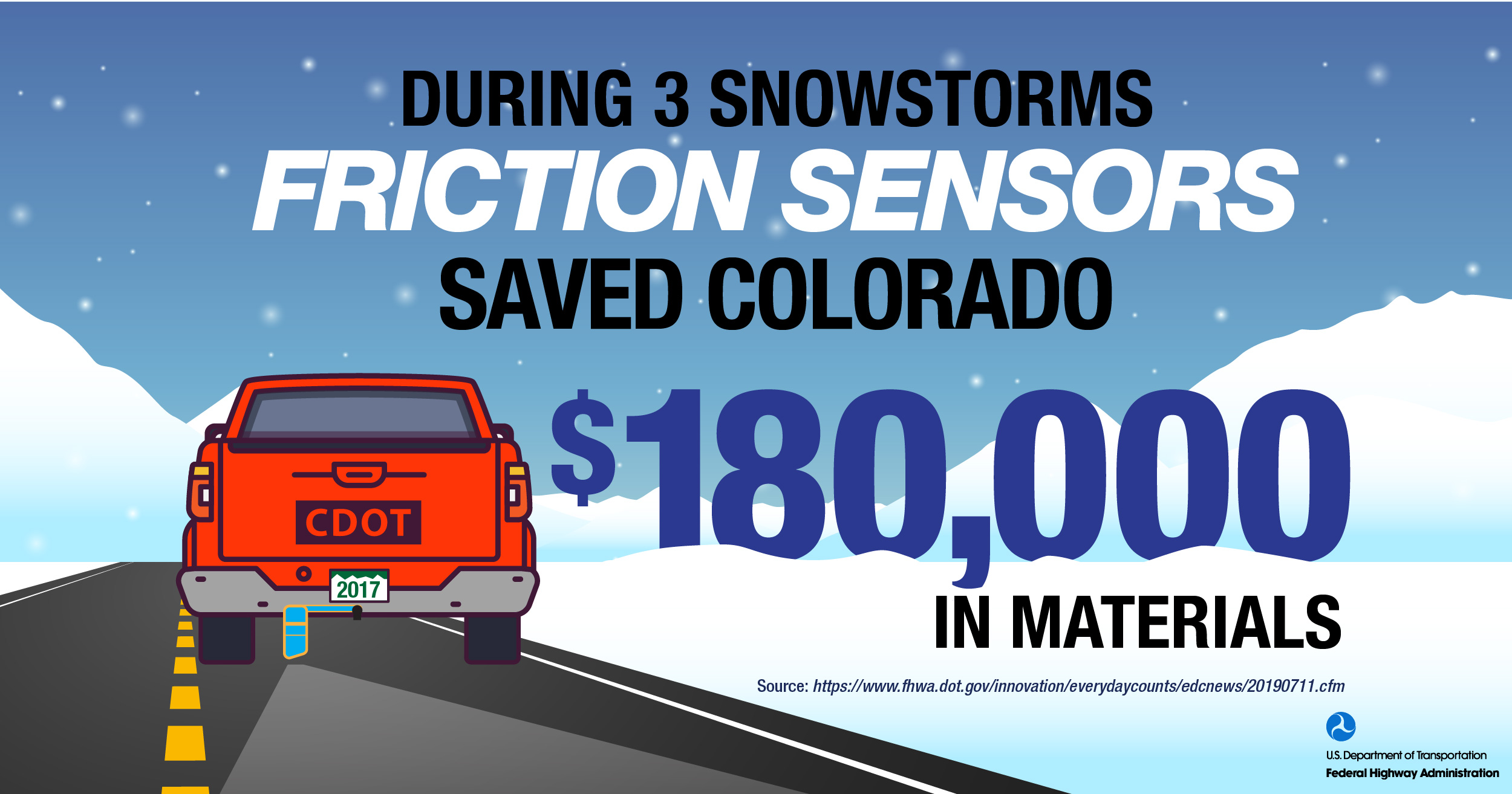
Friction Sensors saved Colorado $180,000 in materials.
A transportation reinvestment zone (TRZ) is a value capture technique that designates areas around transportation projects to encourage development and capture property tax increments to help fund the improvements. TRZs do not raise tax rates; instead, they leverage new property tax revenues generated within the TRZ. The city of El Paso, TX, first used TRZs for its Americas Interchange project. The TRZs covered $30 million in funding for the project, constructed in three phases completed in 2013 to 2016. TRZs now serve as a key funding mechanism to implement El Paso's Comprehensive Mobility Plan. Revenue generated in these zones helped finance several projects in addition to the interchange, and the city anticipates that the TRZs ultimately will generate $70 million for projects in the mobility plan.
EDC Outtakes is a new series of short videos that provide insight on Every Day Counts innovations from State practitioners and Federal Highway Administration staff. In this edition of EDC Outtakes, FHWA's Kevin Moody discusses a staggering statistic on inclement weather crashes and explains why agencies should adopt weather-responsive management strategies to boost the effectiveness of traffic operations and highway maintenance during adverse road weather conditions.
EDC Outtake Series on Weather-responsive Management Strategies featuring Kevin Moody.
Innovator, published by the FHWA Center for Accelerating Innovation, advances implementation of innovative technologies and accelerated project delivery methods in the highway industry. Its audience is transportation professionals in highway agencies, trade and research groups, academia and the private sector, and the driving public.
Elaine L. Chao, Secretary, U.S. DOT
Nicole R. Nason, Administrator, FHWA
Thomas Harman, Director
Jeffrey Zaharewicz, Senior Advisor
Sara Lowry, Program Coordinator
Fawn Thompson, Program Coordinator
Julie Zirlin, Program Manager
Nichole Causey, Marketing Specialist
Ellen Schweppe, Managing Editor
James Cline, Jr., Designer
Pat Holcombe, Designer
Rodney Walker, Designer
Email reprint requests to Nichole Causey
View Innovator archive.

