


STICs Deploy Homegrown Innovations
The sixth round of Every Day Counts (EDC-6) kicked off with a Virtual Summit in December 2020 that introduced the seven innovations FHWA is promoting over the next 2 years. The summit also featured a National State Transportation Innovation Council (STIC) Network Showcase that highlighted 245 innovations in eight topic areas developed and deployed by agencies throughout the country. The following are just a few examples of the expertise and ingenuity agencies have put into action to save lives, time, and money in the areas of technology/materials and pavement/structures.
Among the innovations featured in the STIC Network Showcase were new ideas for improving safety and mobility during hazardous weather. The Kentucky Transportation Cabinet (KYTC) developed snow and ice decision support software that consolidates information for staff responding to weather events and allows them to view the status of operations and weather on a statewide scale. KYTC maintenance and information technology staff teamed to create the dashboard, which displays many different data sources on one map. Since the dashboard is public facing, roadway users can also view the data.

In low visibility conditions, snowplow operators frequently rely on visual cues such as guardrails and road paint to guide equipment. When large snowstorm events cover these visuals or reduce visibility to near zero, guardrails can be damaged, plow drivers can lose their orientation to the road, and dangerous and costly road departures can result. The Oregon Department of Transportation (DOT) deployed GPS-guided equipment for improved maintenance management to reduce this risk to snowplow drivers and the traveling public and to optimize operations.
Dust storms can also result in low or no visibility, severely impacting driving conditions. In some cases, the effects of these storms on traffic along Interstate 10 in New Mexico have been severe. The New Mexico DOT installed its I-10 Dust Storm Detection and Notification System to advise the public of severe dust storms and provide appropriate actions to greatly reduce the likelihood of associated crashes. The system monitors local conditions and provides the appropriate response in real time without the input of human operators.
The Florida DOT also developed a software solution that increases automation, in this case for submitting, reviewing, approving, and posting data for transportation-related products. The agency’s Product Evaluation Tracking and History Application (PATH) automates processes and communication and manages 2,000 applications annually to produce an approved product list. The agency documented a time savings of 60 hours per week in its Product Evaluation Section, with additional time savings for manufacturers and project engineers.
New technologies and approaches are helping the Texas DOT implement pavement rehabilitation and design strategies for heavy loads. Designing economical, long-life pavements to handle the intense traffic loads present in the State’s energy development areas poses several challenges, including the need to keep the roadway operational at all times. State-of-the-art nondestructive test equipment was used to survey pavement conditions and develop materials handling options to meet early trafficking requirements and recommend improved pavement designs for overloaded vehicles.
The Alaska Department of Transportation & Public Facilities incorporated geophysical investigation methods into its in-house drilling program to obtain better data. The agency used capacitively coupled resistivity and ground penetrating radar equipment to locate subsurface anomalies during drilling programs by targeting borings more efficiently. This has resulted in cheaper and faster, but more thorough, geotechnical investigations, saving costs in design and reducing claims during construction.
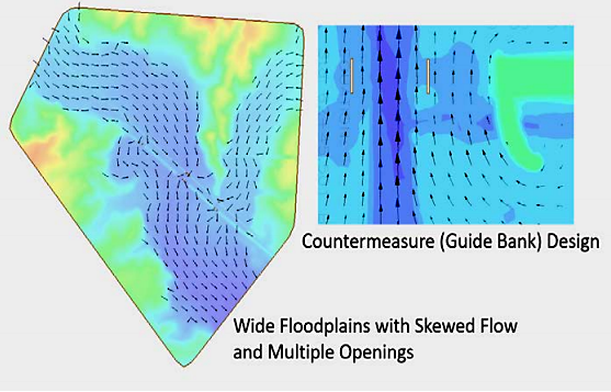
The Mississippi DOT implemented Sedimentation and River Hydraulics – Two-Dimension (SRH-2D) modeling for most of its bridge hydraulic projects.
Credit: Mississippi DOTThe Mississippi DOT is using two-dimensional (2D) modeling for complex bridge hydraulics to inform, verify, and refine efficient designs. The agency reported that 2D hydraulic modeling better represents the physics of flow, provides more realistic hydraulic results compared to one-dimensional methods, and is better suited to model the site conditions commonly encountered with bridges throughout the State.
FHWA’s Office of Federal Lands Highway is performing pavement structural evaluation using traffic speed deflectometers (TSD), which measure pavement response to wheel load at traffic speed using a set of trailer-mounted, velocity-sensing lasers. TSD-based structural condition data can be incorporated into pavement management systems at the network level. Compared to traditional methods that require lane closures, TSD provides faster, safer data collection and processing.
—MORE INFORMATION
Register for access to the EDC-6 Virtual Summit on-demand content to learn more about these and other homegrown innovations. After registering, click on the National STIC Network Showcase button.
Recommended Citation: U.S. Department of Transportation, Federal Highway Administration - Washington, DC (2021) Innovator Newsletter, July/August 2021, Volume 15(85). https://doi.org/10.21949/1521363