


Connecticut Takes a GIS-Based Approach to Digital As-Builts
Agencies have traditionally created as-built drawings by recording design and construction changes on paper plan sheets or PDFs and filing them away—which captures some details at the time of construction, but does not communicate them efficiently for maintenance, operations, and asset management. Many agencies are moving toward digital as-builts, which are created with the digital data collected in real time as the project is designed and constructed. Digital as-builts allow data to be contributed by various partners during project delivery, validated by agencies as part of an enterprise data management system, and easily used by others.
The Connecticut Department of Transportation (CTDOT) is developing integrated applications and workflows to enhance its digital as-builts by leveraging geographic information system (GIS) data. In using this approach, important infrastructure elements (assets) are inventoried, maintained, and replaced. CTDOT’s plan is that all highway infrastructure elements will be inventoried, maintained, identified, and programmed for replacement, removal, or rehabilitation using project development and asset management principles in a GIS-based system.
GIS in leu of Plans
CTDOT is currently using GIS for spatially challenged projects such as highway signs. Prior to 2016, signing projects were developed within a computer-aided design (CAD) environment that was time consuming and outdated for the designer, contractor, and inspector. CTDOT’s sign as-builts were done with PDF markups, which did not contain any data on location or sign removal. In 2016, CTDOT started requiring installation contractors to submit GPS installation data. “The intent was to put the installation data in our inventory as part of the as-built process,” said Barry Schilling, CTDOT transportation supervising engineer. “But we struggled to capture 10 percent of the projects.”
Recently CTDOT employed an app called ArcGIS Field Maps to capture all sign data location and attribution, including sign removals. The sign data now gets de-commissioned and commissioned during the project workflow. Contractors are no longer required to submit GPS installation data because the app verifies the location is as designed, or the contractor can adjust the location as required. The app allows CTDOT to quickly check project status at different locations.
Transforming CAD Features to GIS Features
CTDOT is also developing CAD to GIS data transformations for traffic signal capital project models. Prior to 2015, its traffic signal plan storage consisted of paper copies stored in flat files and CAD files stored on a network drive. After 2015, CTDOT moved to cloud storage of PDF plans and CAD files, but there was no connection between the cloud storage and the agency’s databases. In collaboration with the University of Connecticut, CTDOT began developing an Esri-based solution for managing the traffic signals inventory.
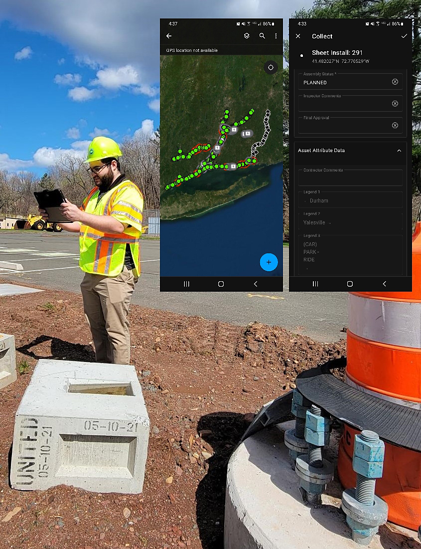
Connecticut DOT uses an app for collecting and updating sign data in the field.
Credit: Connecticut Department of TransportationOnce the data model (schema) was developed, CTDOT began developing the item types attribution for the CAD signal features using Bentley OpenRoads™ Designer. This underlying CAD feature intelligence will be packaged into a traffic signal workspace for CTDOT and consultant engineers, who will benefit from the auto harvesting of contract item quantities. This information will then be extracted, transformed, and loaded (ETL) into the Esri signal inventory by CTDOT using Safe Software’s FME® (Feature Manipulation Engine). A quality assurance process developed in FME by CTDOT is then performed.
“This is going to remove those silos,” said Elaine Richard, CTDOT civil applications and CAD coordinator. “We’re going to be able to create a seamless flow of information from design to construction, to inventory. Using item types, we’ll be able to provide project information, attribution on the graphical elements and geolocation of each component.”
GIS-Based Project Management
Over the past 3 years, the Bureau of Engineering and Construction developed a Microsoft Azure cloud-based SharePoint™ project management solution. In parallel, CTDOT is developing a new Esri Azure cloud-based GIS infrastructure.
CTDOT’s SharePoint solution, COMPASS, was scoped to manage all project submittals and transmittals so that completed document reviews and approvals are automatically passed to the next reviewer. The agency said the application has been very successful and is standardizing the project management environment while also becoming a common data environment for project data, including models for both CAD and Building Information Modeling (BIM). Bruce Bourgoin, CTDOT supervising engineer, said COMPASS is basically a one-stop-shop giving users access to CTDOT’s project data and documents.
The Esri build out has developed a robust portal environment along with internal enterprise data governance, change management, and distributed subject matter experts across the agency. Within this new environment, CTDOT worked with a GIS developer to create an application named ATLAS 2.0.
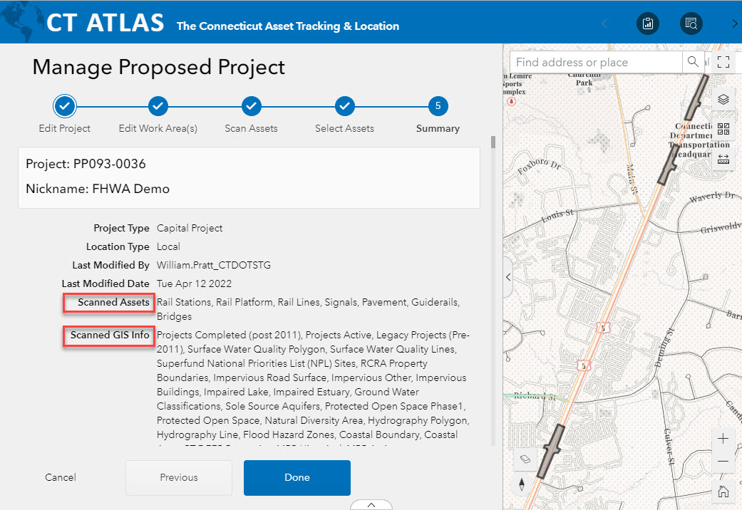
This ATLAS screenshot shows the results of an asset and information scan.
Credit: Connecticut Department of TransportationATLAS 2.0 is built in a progressive Esri Experience Builder™ environment that allows users to identify proposed project work area(s) and hands out unique project identifiers that get joined with contract project numbers once available. The application allows the configuration of underlying asset inventories including linear referencing system routes, bridges, traffic signals, and others. These configured asset inventories are then available for automated scans for project inclusion. ATLAS 2.0 is being integrated with COMPASS so that the results of these scans get pushed to the SharePoint project site.
This ATLAS/COMPASS integration will provide information to asset inventories on decommissioning, rehabilitation, or preservation of each asset within a project. It also provides a draft permit needs determination and any spatial connections with active and historical projects. The CAD to GIS data transformations will drive commissioning of new or replaced assets. “This direct collaboration with our asset inventories is CTDOT’s vision for digital as-builts” said Bill Pratt, who is managing CTDOT’s digital as-built initiative.
—MORE INFORMATION
Contact FHWA’s Bryan Cawley or David Unkefer for digital as-built resources and technical assistance.
Visit FHWA’s Every Day Counts e-Ticketing and Digital As-Builts webpage.
Notice: The U.S. Government does not endorse products or manufacturers. Trademarks or manufacturers’ names appear in this article only because they are considered essential to the objective of the document.
Recommended Citation: U.S. Department of Transportation, Federal Highway Administration - Washington, DC (2022) Innovator Newsletter, May/June 2022, Volume 15 (90). https://doi.org/10.21949/1521808