

This fact sheet introduces planning, engineering, and design practitioners to the Institute of Transportation Engineer’s recommended practice (RP) Designing Walkable Urban Thoroughfares:A Context Sensitive Approachas a tool for designing urban streets that are compatible with and supportive of the surrounding context and community. This fact sheet provides an overview of how the RP’s “design framework” is used in developing the initial concepts for walkable thoroughfares that are compatible with the adjacent context the thoroughfare serves. The framework is intended to reflect a design philosophy that emphasizes understanding how the multimodal activity generated by the adjacent context affects the thoroughfare design.
The design of a thoroughfare helps to define context as much as adjacent land uses and buildings. The conventional design process prioritizes vehicular mobility and access using functional classification, design speed, traffic volume, and vehicular level of service as the determinants for design criteria—an approach with limited sensitivity to the surrounding context. Applying the principles of CSS in thoroughfare design identifies new opportunities to integrate thoroughfares into their surroundings and supports the activities of the adjacent land uses.
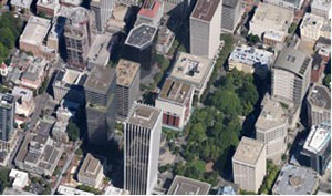
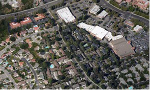
Every thoroughfare has an immediate physical context created by buildings, landscape, and activities on adjacent properties and is also part of a broader context created by the surrounding neighborhood or district. While the elements of context can combine in infinite varieties, this RP uses four context zones to define and categorize urban areas. The four context zones are suburban (C-3), general urban (C-4), urban center (C-5), and urban core (C-6). See Table 1 for a description of context zones. Figures 2 and 3 illustrate how context varies from suburban to urban core.
| Context Zone | Distinguishing Characteristics | General Character |
|---|---|---|
| C-1 Natural | Natural landscape | Natural features |
| C-2 Rural | Agricultural with scattered development | Agricultural activity and natural features |
| C-3 Suburban | Primarily single family residential with walkable development pattern and pedestrian facilities, dominant landscape character | Detached buildings with landscaped yards |
| C-4 General Urban | Mix of housing types including attached units, with a range of commercial and civic activity at the neighborhood and community scale | Predominantly detached buildings, balance between landscape and buildings, prescence of pedestrians |
| C-5 Urban Center | Attached housing types such as townhouses and apartments mixed with retail, workplace, and civic activities at the community or sub-regional scale | Predominantly attached buildings landscaping within the public right of way, substantial pedestrian activity |
| C-6 Urban Core | Highest-intensity areas in sub-region or region, with high-density high rise residential and workplace uses, entertainment, civic, and cultural uses | Attached buildings forming sense of enclosure and continuous street wall landscaping within the public right of way, highest pedestrian and transit activity |
| Districts | To be designated and described locally, districts are areas that are single-use or multi-use with low-density development patterns such as airports, business parks, universities, and industrial areas. | |
Thoroughfare type is a classifying system that governs the selection of design criteria and, along with the context, is used to determine the physical configuration of a thoroughfare’s streetside (the area between the curb and property line), traveled way, and intersections. The RP uses three thoroughfare classifications: boulevards, avenues, and streets. Boulevards are multilane divided thoroughfares that serve a mix of regional and local traffic and carry the most important transit routes. Avenues can be up to four lanes with a median and serve some regional but mostly local traffic. Streets are two lanes and serve predominantly local traffic. In urban areas, any of the three thoroughfare types may accommodate high levels of pedestrian and bicycle activity.
Thoroughfares governed by functional classification and conventional design standards result in a predetermined configuration that ensures the thoroughfare is designed consistently, regardless of its context. While this approach is valuable in many circumstances, it can be a source of conflict in walkable communities because the design may not be compatible with its surroundings or may fail to address community concerns and interests. The concept of context zones and thoroughfare types provides guidance that supplements conventional design standards. These concepts inform the designer of the needs of a specific context and encourage working with stakeholders and the community to create compatible thoroughfare designs.
Conventional thoroughfare design is driven by traffic demand and level of service objectives. The design process usually starts with functional classification and number of lanes. These fundamental criteria (functional class and lanes) are independent of the adjacent context except whether the thoroughfare is located in a rural or urban setting.
A design process integrating the principles of CSS emphasizes that as context changes, thoroughfare design should also change to support the activity generated by the context. As the intensity of adjacent land uses increase, the streetside should also accommodate the resulting increase in the diversity of functions. Similarly, the traveled way should emphasize support for context-related activities such as on-street parking, bike travel, transit stops, land access, and pedestrian- friendly intersections, often requiring the need to balance automobile capacity and other multimodal design elements.
Much like the “rural” and “urban” classifications that are used in selecting design criteria in A Policy on the Geometric Design of Streets and Highways by the American Association of State Highway and Transportation Officials, context zones are a basic determinant of a walkable thoroughfare’s design criteria. The RP defines and describes context zones. Guidelines for identifying context zones include:
The RP emphasizes thoroughfares in areas with traditional urban qualities—compact, walkable, highly accessible mixed-use environments—the design of which is governed by both functional class and thoroughfare type. Use functional class to determine:
Use thoroughfare types (boulevards, multiway boulevards, avenues, and streets) to select design criteria and, along with the surrounding context, to determine the physical configuration of the thoroughfare and its single most important design control: target speed (see “Fact Sheet 3”).
Once known, the thoroughfare type is used to identify the components and dimensions of the streetside (e.g., sidewalks, planting strips, street furniture), the traveled way (e.g., lanes, medians, on-street parking, bike lanes), and intersections. Other considerations linked to the thoroughfare type include the type of transit technology and service, the level of access management, and the type of freight service that can be accommodated by the thoroughfare’s design. The relationship between functional classification and thoroughfare type is shown in Table 2.
| Thoroughfare Type | ||||||||
|---|---|---|---|---|---|---|---|---|
| Functional Class | Freeway/Expressway/Parkway | Rural Highway | Suburban Arterial | Boulevard | Avenue | Street | Rural Road | Alley/Rear Lane |
| Principal Arterial | x | x | x | x | x | x | ||
| Minor Arterial | x | x | x | x | x | |||
| Collector | x | x | ||||||
| Local | x | x | x | |||||
Note: Thoroughfare types ‘Freeway/Expressway/Parkway,’ ‘Rural Highway,’ ‘Suburban Arterial,’ ‘Rural Road,’ and ‘Alley/Rear Lane’ are not addressed in this report.
Institute of Transportation Engineers, 1627 Eye Street, NW, Suite 600, Washington, DC 20006 USA; Phone: 202-785-0060; www.ite.org.
This project was funded by FHWA’s Office of Planning, Environment and Realty’s Surface Transportation Environment and Planning Cooperative Research Program and the Environmental Protection Agency. Download the recommended practice and additional fact sheets at: www.ite.org/css/.

