The Berkeley-Charleston-Dorchester Council of Governments (BCDCOG) is the federally designated MPO/TMA for the Charleston MSA in South Carolina. BCDCOG is involved in all levels of regional transportation planning and staffs the MPO's transportation planning body, known as the Charleston Area Transportation Study (CHATS). BCDCOG has a federally mandated responsibility for planning, programming, and budgeting of transportation improvements in the three county region with a population of 664,607 residents (2010 Census).
To conduct quantitative assessments of the regional transportation system, BCDCOG employs a traditional 4-step trip-based modeling framework using the TransCAD software package.
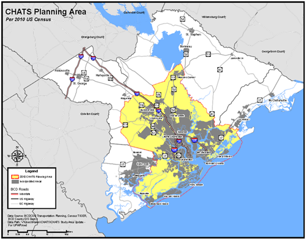
The Charleston Area Transportation Study (CHATS) area encompasses 2,600 square miles of the tri-county region's most urbanized areas. Generally, the study area contains the Census defined Urbanized Area (UZA), and all the land expected to be urbanized within the next 20 years. It now consists of portions of all three counties in the BCD Region. The study area includes:
· Summerville & surrounding areas;
Figure 2‑1 shows the CHATS study area in the BCDCOG region. This is the fastest growing area in South Carolina and the number of households is projected to increase from 249,569 in 2010 to over 300,000 by 2035.
The region's urban core is located on the historic Charleston peninsula and the majority of traffic flows are along the I-26 corridor into downtown Charleston and along the I-526 ring. These roadways record the highest congestion in South Carolina and congestion in the Charleston area is ranked high by TTI's Urban Mobility compared to other medium-sized MPOs.
There are no toll roads or managed lane facilities within the region. At his point, there is no plan for future toll roads or public-private-partnerships in the region, although there are toll facilities in the state and there is no explicit legislation preventing toll facilities.
Transit in the Charleston region is operated by the Charleston Area Regional Transit Authority (CARTA). CARTA offers Fixed-route, Flex Service, Express commute service, and Paratransit service throughout the Charleston Metropolitan area, including The Trolley (DASH) service in the Historic Peninsula area of the Charleston. A fixed-guideway transit project study is underway. Approximately 95% of current transit riders are captive.
Some unique aspects to the BCDCOG region include the Port of Charleston, Joint Base Charleston, a United States military facility, and several colleges, including The Citadel and College of Charleston as well as a thriving tourist industry. The Port of Charleston is the fourth busiest port on the eastern seaboard. The port operates as an intermodal facility and utilizes distribution centers in the region. Tourism is a four billion dollar industry in Charleston. Cruise ships frequent a commercial port in the historic downtown and Charleston hosts major events such as the PGA tour.
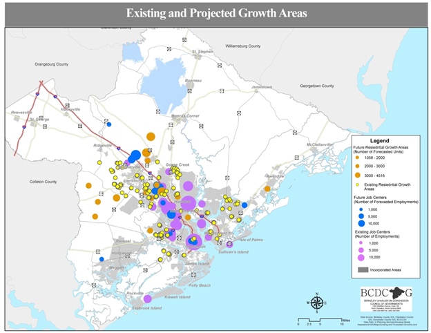
Much of the land in the area is wetlands and not developable; therefore much of the development has few access points, and cul-de-sacs are prevalent. Figure 2‑2 shows the existing and projected growth areas. These are concentrated along the I-26 and I-526 corridors.