U.S. Department of Transportation
Federal Highway Administration
1200 New Jersey Avenue, SE
Washington, DC 20590
202-366-4000
Federal Highway Administration Research and Technology
Coordinating, Developing, and Delivering Highway Transportation Innovations
| FACT SHEET |
| This fact sheet is an archived publication and may contain dated technical, contact, and link information |
| Publication Number: FHWA-HRT-12-024 Date: January 2012 |
Publication Number: FHWA-HRT-12-024 Date: January 2012 |

PDF files can be viewed with the Acrobat® Reader®

|
The growth of major metropolitan areas over the last century has resulted in the emergence of “mega-regions”—a large network of urban areas that often develop along major transportation routes. Expected to form an essential role in the future global economy, new analysis tools are needed to operate these mega-regional transportation networks efficiently. “Mega-Regional Travel,” a Federal Highway Administration (FHWA) Exploratory Advanced Research (EAR) Program study, was awarded to the University of Maryland to investigate the regional impact of transportation policy decisions. |
The study aims to develop and test a mega-regional travel demand modeling framework using a large corridor stretching from Baltimore, MD, to Virginia Beach, VA, as a case study. This framework will be examined and expanded to cover a larger mega-region comprised of Washington, DC, and parts of four other States: Maryland, Virginia, Delaware, and Pennsylvania. Researchers aim to use the case study to address some of the technical challenges faced when developing a modeling framework and tools on such a large scale.
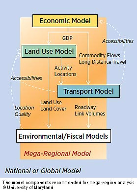
The study will test several scenarios on the mega-region to demonstrate the ability of the modeling framework in real-world situations. A selection of analysis tools measure the outcome of future scenarios using factors including economic change, land use, and travel demand at national, regional, and local levels. Other impacts of the mega-region, in addition to transportation measures, can also be identified—these could include air quality, water quality, and fiscal and economic impacts.
The study involves a number of transportation pricing experiments to examine how changes in prices affect travel behavior, land use, economic growth, residential energy consumption, and the environment throughout the region. Researchers can increase prices in different ways, at different places, at different times, and in different amounts to focus on scenarios that would impact passenger and freight trips within the model with the most price sensitivity.
Several factors make the geography of mega-regions different from that of traditional metropolitan planning organizations and States. These factors include the issues defining the mega-region, the economic and transportation interactions with other mega-regions and the rest of the country, and the scale of the problems addressed. It is issues, rather than political boundaries, that define and outline a mega-region, and these defining issues may be related to:

Mega-regions pose many challenges to planners and policymakers because they span local and State political jurisdictions, complicating efforts to devise and implement coordinated policies. These multiple scales make it particularly important for mega-regions to expand beyond the technical methods found in traditional transportation planning models. A multidisciplinary approach may be necessary, in order to integrate economic, transport, land use, and emissions models. Multiscale project evaluations may need to be conducted to include larger megaregional scales, such as high speed rail and truck corridors, and smaller scale neighborhood projects. Multimodal transportation networks may also need to be evaluated, including highway, bus, rail, and air travel. In addition, all trip purposes will need to be encompassed—including short- and long-distance travel. Building on an existing multilayer modeling system, this project focuses on transportation policy decisions and how the cost and pricing of different regional transportation investments affects travel performance in the larger mega-region.
“Currently, individual metropolitan areas do not always have sufficient incentives to improve connections to neighboring metropolitan areas because the benefits of their investments will often flow to other areas,” says Supin Yoder at FHWA. “However, mega-regional coordination of transportation planning and investments addresses this need and in addition has several benefits potentially affecting development of several transportation areas, including high-speed rail, congestion management, cargo expressways, truck lanes, and port expansion.”
The strategy is also ideal from a logistical standpoint because it becomes possible to encompass parts of a supply chain—minimizing freight bottlenecks and coordinating intermodal connections. Yoder explains, “Improving the flow of goods and commodities in such a way within mega-regions, and beyond to the worldwide markets, may ultimately assist a region when competing in the global marketplace.”
For more information on the University of Maryland project, contact Supin Yoder at FHWA, 708-283-3554 (email: supin.yoder@dot.gov).

What Is the Exploratory Advanced Research Program?FHWA’s Exploratory Advanced Research (EAR) Program focuses on long-term, high-risk research with a high payoff potential. The program addresses underlying gaps faced by applied highway research programs, anticipates emerging issues with national implications, and reflects broad transportation industry goals and objectives. To learn more about the EAR Program, visit the Exploratory Advanced Research Web site at www.fhwa.dot.gov/advancedresearch. The site features information on research solicitations, updates on ongoing research, links to published materials, summaries of past EAR Program events, and details on upcoming events. For additional information, contact David Kuehn at FHWA, 202-493-3414 (email: david.kuehn@dot.gov), or Terry Halkyard at FHWA, 202-493-3467 (email: terry.halkyard@dot.gov). |