U.S. Department of Transportation
Federal Highway Administration
1200 New Jersey Avenue, SE
Washington, DC 20590
202-366-4000


Skip to content
Facebook iconYouTube iconTwitter iconFlickr iconLinkedInInstagram

Federal Highway Administration Research and Technology
Coordinating, Developing, and Delivering Highway Transportation Innovations

Report
This report is an archived publication and may contain dated technical, contact, and link information

Publication Number: FHWA-HRT-05-159
Date: June 2006

Previous | Table of Contents | Next

Design and Construction of Driven Pile Foundations – Lessons Learned on The Central Artery/Tunnel Project

Chapter 2. Driven Pile Design Criteria and Specifications

This chapter presents the pile design criteria and specifications used on the CA/T project in contracts C07D1, C07D2, C08A1, C09A4, and C19B1. These include information on the types of piles used, capacity requirements, minimum preaugering depths, and testing requirements. The subsurface conditions on which the design criteria were based are also discussed.

SUBSURFACE CONDITIONS

Representative soil profiles from each of the contract sites are shown in figures 2 through 6 based on the interpretation of geotechnical borings. (See references 4, 5, 6, 7, 8, 9, and 10)

As shown in figures 2 through 5, the conditions encountered at sites in East Boston (C07D1, C07D2, and C08A1) and in downtown Boston (C09A4) are similar. The subsurface conditions at these locations typically consisted of fill overlying layers of organic silt, inorganic sand or silt, marine clay, glacial soils, and bedrock. The subsurface conditions shown in figure 6 for the C19B1 site in Charlestown, however, were different from the other four sites. Organic soils and marine clays were only encountered to a limited extent at the site. Also, the thickness of the fill layer was greater relative to the other sites.

The physical properties and geological origin of the soils encountered at the contract sites are described below.(11-12)

Bedrock: The bedrock in the area consists of argillite from the Cambridge formation. The condition of the bedrock varies considerably with location, even within a given site. Evaluation of rock core samples indicates that the rock is typically in a soft and weathered condition and contains a significant amount of fracturing. However, hard and sound bedrock was found at some locations.

Glacial Soils: The glacial soils were deposited during the last glaciation approximately 12,000 years ago. These deposits include glacial till, and glaciomarine, glaciolacustrine, and glaciofluvial soils. Till is characterized by a mass of unsorted debris that contains angular particles composed of a wide variety of grain sizes, ranging from clay-sized particles to large boulders. Glaciomarine or glaciolacustrine deposits generally consist of clay, silt, and sand, whereas glaciofluvial deposits contain coarser grained sand and gravel. The glacial soils are typically dense in nature as indicated by high standard penetration test (SPT) resistance, and the piles were typically terminated in these deposits.

Marine Soils: Marine soils were deposited over the glacial soils during glacial retreat in a quiescent deepwater environment. The marine clay layer, as shown in figures 2 through 5, is the thickest unit in the profile, but was encountered only to a limited extent at the Charlestown site. The clay is generally overconsolidated in the upper portions of the layer and is characterized by relatively higher strengths. The overconsolidation is a result of past desiccation that occurred during a period of low sea level. By comparison, the deeper portions of the clay layer are much softer and penetration of the SPT split spoon can sometimes occur with just the weight of the drilling rods alone.

Inorganic Soils: Inorganic silts and sands are typically encountered overlying the marine soils. These soils were deposited by alluvial processes.

Organic Soils: The organic soils that are encountered below the fill generally consist of organic silt and may contain layers of peat or fine sand. These soils are the result of former tidal marshes that existed along the coastal areas.

Fill Soils: Fill material was placed in the more recent past to raise the grade for urban development. The fill layer is highly variable in its thickness and composition, ranging from silts and clays to sands and gravels. The consistency or density is also variable as indicated by the SPT blow counts. The variability in the fill is attributed to the characteristics of the particular borrow source material and the methods of placement.

Figure 2. Graph. Soil profile at the contract C07D1 site as encountered in Boring EB3-5. This figure has three components. The first component, on the left side of the figure, is a graph consisting of data points connected by a line. The x axis is the standard penetration test N value, with N referring to the number of blows to drive a pile. The x axis is a logarithmic scale from 1 to 100. The y axis is the depth in meters and descends from zero to 55. Each data point indicates the number of blows required to drive a pile to that depth from the previous recorded depth, or data point. The second component is a bar chart indicating the depths of various types of soil. The bar chart is beside the graph of data points and connecting line, and uses the same y axis parenthesis depth in meters, descending from zero to 55 end parenthesis. For fill soil, the information provided by the graph and chart is as follows: approximate depth range in meters, zero to 6; approximate number of data points, 4; range of number of blows from preceding data point, 9 to 30. For organic silt, the information provided by the graph and chart is as follows: approximate depth range in meters, zero to 6; approximate number of data points, 1; range of number of blows from preceding data point, 1. For sand, the information provided by the graph and chart is as follows: approximate depth range in meters, 7 to 11; approximate number of data points, 2; range of number of blows from preceding data point, 20 to 30. For marine clay, the information provided by the graph and chart is as follows: approximate depth range in meters, 11 to 44; approximate number of data points, 22; range of number of blows from preceding data point, 1 to 10. For sand parenthesis glaciofluvial end parenthesis, the information provided by the graph and chart is as follows: approximate depth range in meters, 44 to 46; approximate number of data points, 1; range of number of blows from preceding data point, 90. For glacial till, the information provided by the graph and chart is as follows: approximate depth range in meters, 46 to 51; approximate number of data points, 4; range of number of blows from preceding data point, 30 to 100. For bedrock, the information provided by the graph and chart is as follows: approximate depth range in meters, 51 to 55; approximate number of data points, 1; range of number of blows from preceding data point, 100. The third component of the figure indicates the embedment depth of test pile ET2-C2, which is adjacent to Boring EB3-5. The embedment depth is approximately 49 meters.
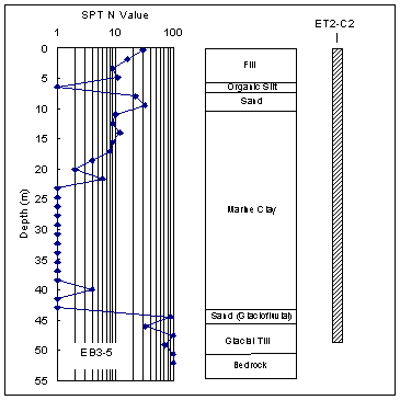
Figure 2. Soil profile at the contract C07D1 site as encountered in Boring EB3-5.

Figure 3. Graph. Soil profile at the contract C07D2 site as encountered in Boring EB2-149. This figure has three components. The first component, on the left side of the figure, is a graph consisting of data points connected by a line. The x axis is the standard penetration test N value, with N referring to the number of blows to drive a pile. The x axis is a logarithmic scale from 1 to 100. The y axis is the depth in meters and descends from zero to 40. Each data point indicates the number of blows required to drive a pile to that depth from the previous recorded depth, or data point. The second component is a bar chart indicating the depths of various types of soil. The bar chart is beside the graph of data points and connecting line, and uses the same y axis: depth in meters descending from zero to 40. For fill soil, the information provided by the graph and chart is as follows: approximate depth range in meters, zero to 4.5; approximate number of data points, 3; range of number of blows from preceding data point, 2 to 35. For organic silt, the information provided by the graph and chart is as follows: approximate depth range in meters, 4.5 to 6; approximate number of data points, 1; range of number of blows from preceding data point, 5. For sand, the information provided by the graph and chart is as follows: approximate depth range in meters, 6 to 9; approximate number of data points, 2; range of number of blows from preceding data point, 30 to 40. For marine clay, the information provided by the graph and chart is as follows: approximate depth range in meters, 9 to 27; approximate number of data points, 11; range of number of blows from preceding data point, 6 to 11. For silt parenthesis glaciomarine end parenthesis, the information provided by the graph and chart is as follows: approximate depth range in meters, 27 to 38; approximate number of data points, 7; range of number of blows from preceding data point, 40 to 100. For bedrock, the information provided by the graph and chart is as follows: approximate depth range in meters, 38 to 40; approximate number of data points, zero; range of number of blows from preceding data point, not applicable. The third component of the figure indicates the embedment depth of test pile 923, which is adjacent to Boring EB2-149. The embedment depth is approximately 32 meters.
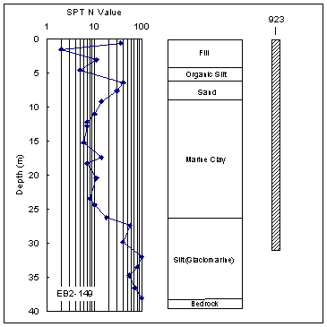
Figure 3. Soil profile at the contract C07D2 site as encountered in Boring EB2-149.


Figure 4. Graph. Soil profile at the contract C08A1 site as encountered in Boring EB6-37. This figure has three components. The first component, on the left side of the figure, is a graph consisting of data points connected by a line. The x axis is the standard penetration test N value, with N referring to the number of blows to drive a pile. The x axis is a logarithmic scale from 1 to 100. The y axis is the depth in meters and descends from zero to 70. Each data point indicates the number of blows required to drive a pile to that depth from the previous recorded depth, or data point. The second component is a bar chart indicating the depths of various types of soil. The bar chart is beside the graph of data points and connecting line, and uses the same y axis: depth in meters descending from zero to 70. For fill soil, the information provided by the graph and chart is as follows: approximate depth range in meters, zero to 4; approximate number of data points, 3; range of number of blows from preceding data point, 5 to 30. For silt and sand soil, the information provided by the graph and chart is as follows: approximate depth range in meters, 4 to 10; approximate number of data points, 3; range of number of blows from preceding data point, 10 to 30. For marine clay, the information provided by the graph and chart is as follows: approximate depth range in meters, 10 to 40; approximate number of data points, 20; range of number of blows from preceding data point, 1 to 7. For sand and gravel parenthesis glaciofluvial end parenthesis, the information provided by the graph and chart is as follows: approximate depth range in meters, 40 to 65; approximate number of data points, 15; range of number of blows from preceding data point, 30 to 100. For bedrock, the information provided by the graph and chart is as follows: approximate depth range in meters, 65 to 70; approximate number of data points, 3; range of number of blows from preceding data point, 100. The third component of the figure indicates the embedment depth of test pile ET2-C2, which is adjacent to Boring EB6-37. The embedment depth is approximately 45 meters.
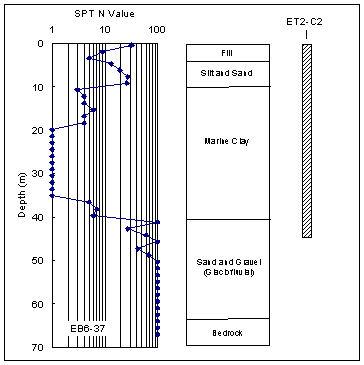
Figure 4. Soil profile at the contract C08A1 site as encountered in Boring EB6-37.

Figure 5. Graph. Soil profile at the contract C09A4 site as encountered in Boring IC10-13. This figure has three components. The first component, on the left side of the figure, is a graph consisting of data points connected by a line. The x axis is the standard penetration test N value, with N referring to the number of blows to drive a pile. The x axis is a logarithmic scale from 1 to 100. The y axis is the depth in meters and descends from zero to 25. Each data point indicates the number of blows required to drive a pile to that depth from the previous recorded depth, or data point. The second component is a bar chart indicating the depths of various types of soil. The bar chart is beside the graph of data points and connecting line, and uses the same y axis: depth in meters descending from zero to 25. For fill, the information provided by the graph and chart is as follows: approximate depth range in meters, zero to 3; approximate number of data points, 2; range of number of blows from preceding data point, 5 to 30. For organic silt, the information provided by the graph and chart is as follows: approximate depth range in meters, 3 to 7; approximate number of data points, 2; range of number of blows from preceding data point, 4 to 5. For marine clay, for which the data points are in two unconnected groups, the information provided by the graph and chart is as follows: approximate depth range in meters, 7 to 41; approximate number of data points in first group, 2; approximate number of data points in second group, 11; range in first group of number of blows from preceding data point, 30 to 50; range in second group of number of blows from preceding data point, 1 to 7. For sand and silt parenthesis glaciofluvial end parenthesis, the information provided by the graph and chart is as follows: approximate depth range in meters, 41 to 45; approximate number of data points, 3; range of number of blows from preceding data point, 60 to 100. For bedrock, the information provided by the graph and chart is as follows: approximate depth range in meters, 45 to 50; approximate number of data points, zero; range of number of blows from preceding data point, not applicable. The third component of the figure indicates the embedment depth of test pile 12A1-1, which is adjacent to Boring IC10-13. The embedment depth is approximately 44 meters.
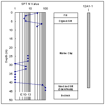
Figure 5. Soil profile at the contract C09A4 site as encountered in Boring IC10-13.

Figure 6. Graph. Soil profile at the contract C19B1 site as encountered in Boring AN3-101. This figure has three components. The first component, on the left side of the figure, is a graph consisting of data points connected by a line. The x axis is the standard penetration test N value, with N referring to the number of blows to drive a pile. The x axis is a logarithmic scale from 1 to 100. The y axis is the depth in meters and descends from zero to 25. Each data point indicates the number of blows required to drive a pile to that depth from the previous recorded depth, or data point. The second component is a bar chart indicating the depths of various types of soil. The bar chart is beside the graph of data points and connecting line, and uses the same y axis: depth in meters descending from zero to 25. For granular fill, the information provided by the graph and chart is as follows: approximate depth range in meters, zero to 10; approximate number of data points, 6; range of number of blows from preceding data point, 2 to 50. For sand, the information provided by the graph and chart is as follows: approximate depth range in meters, 10 to 14; approximate number of data points, 3; range of number of blows from preceding data point, 8 to 60. For gravel parenthesis glaciomarine end parenthesis, the information provided by the graph and chart is as follows: approximate depth range in meters, 14 to 18; approximate number of data points, 3; range of number of blows from preceding data point, 90 to 100. For glacial till, the information provided by the graph and chart is as follows: approximate depth range in meters, 18 to 22.5; approximate number of data points, 1; range of number of blows from preceding data point, 100. For bedrock, the information provided by the graph and chart is as follows: approximate depth range in meters, 22.5 to 25; approximate number of data points, 1; range of number of blows from preceding data point, 100. The third component of the figure indicates the embedment depth of test pile IPW, which is adjacent to Boring AN3-101. The embedment depth is approximately 23 meters.
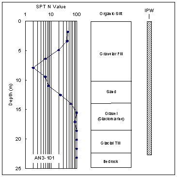
Figure 6. Soil profile at the contract C19B1 site as encountered in Boring AN3-101.

DESIGN CRITERIA AND SPECIFICATIONS

The variable fill and compressible clay soils encountered at depth necessitated the use of deep foundations. Driven piles were selected, and design criteria and specifications were developed for their installation, ultimate capacity, and testing. Because the CA/T project was located in Massachusetts, the design criteria were required to satisfy the regulations given in the Massachusetts State building code.(13) The technical content of the State code is based on the 1993 edition of the Building Officials and Code Administrators (BOCA) national building code.

The specifications that were used for each CA/T contract are contained in two documents of the Massachusetts Highway Department (MHD). The first document includes the general requirements for all CA/T contracts and is entitled Supplemental Specifications and CA/T Supplemental Specifications to Construction Details of the Standard Specifications for Highways and Bridges (Division II) for Central Artery (I-93)/Tunnel (I-90) Project in the City of Boston.(14)

The specifications pertaining to individual contracts are covered in a second document concerning special provisions.(15) The special provisions are necessary given the uniqueness of the environmental conditions, soil conditions, and structure types found in each contract. The special provisions present specific details regarding the pile types, pile capacity requirements, and minimum preaugering depths.

Information selected from the specification regarding pile types, preaugering criteria, pile driving criteria, and axial load and test criteria is highlighted below.

Pile Types

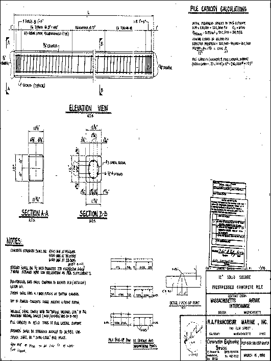
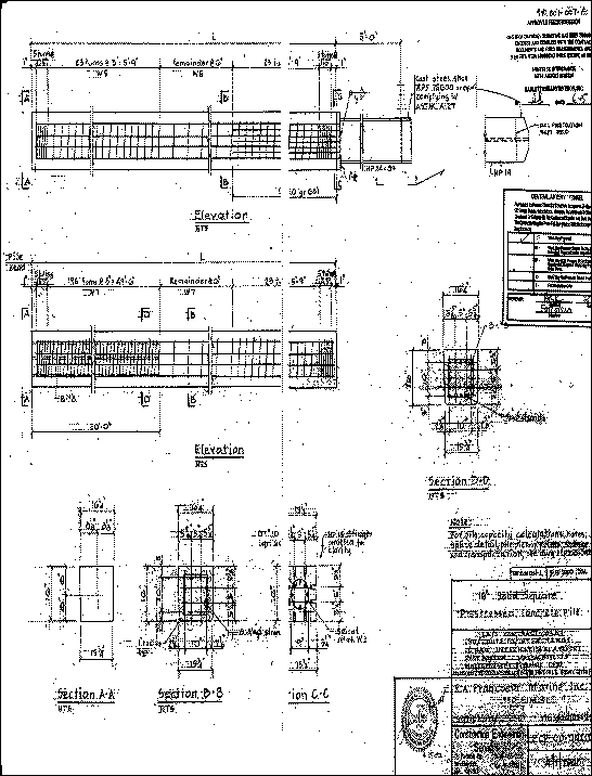
Two types of piles were specified on the selected contracts of the CA/T: (1) PPC piles, and (2) concrete-filled steel pipe piles. The PPC piles were fabricated using 34.5- to 41.3-megapascal (MPa) (28-day strength) concrete and were prestressed to 5.2 to 8.3 MPa. The design drawings of typical 30-centimeter (cm)- and 41-cm-diameter square PPC piles are shown in figures 7 and 8, respectively.

To prevent damage to the pile tips during driving in very dense materials, the PPC piles were also fitted with 1.5-meter (m)-long steel H-pile "stingers." In the 41-cm-diameter PPC piles, an HP14x89 section was used as the stinger. The stingers were welded to a steel plate that was cast into the pile toe, as shown in figure 8. Stingers were used intermittently on the 30-;m-diameter PPC piles, consisting of HP10 by 42 sections.

The concrete-filled steel pipe piles were 31 to 61 cm in diameter, with wall thicknesses ranging from 0.95 to 1.3 cm. The piles were driven closed-ended by welding a steel cone or flat plate onto the pile tip prior to driving. Once the pile was driven to the required depth, the pile was filled with concrete.

A summary of the pile types used on the CA/T is given in table 2, along with the estimated quantities driven. The quantities are based on the contractor's bid quantities that were obtained directly from Bechtel/Parsons Brinckerhoff. As shown in table 2, the 41-cm-diameter PPC piles were the dominant pile type used, accounting for more than 70 percent of the total length of pile driven.

Table 2. Summary of pile types used on the selected CA/T contracts.
Pile Type Estimated Length of Pile Driven (m)
C07D1 C07D2 C08A1 C09A4 C19B1 Total
32-cm pipe
-
-
-
-
5,550
5,550
41-cm pipe
-
-
-
5,578
-
5,578
61-cm pipe
-
-
-
-
296
296
30-cm square PPC
7,969
3,981
792
3,658
2,177
18,577
41-cm square PPC
32,918
19,879
8,406
14,326
6,279
81,808

Preaugering Criteria

Preaugering was specified for all piles that were installed in embankments or within the specified limits of adjacent structures. Settlement problems observed at the Hilton hotel (contract C07D1) initiated the use of preaugering to reduce the potential for soil heave caused by pile installation. Soil heave is discussed further in chapter 3. The required depth of preaugering varied depending on the contract and pile location, but ranged from 7.6 to 32.0 m below the ground surface.

Pile Driving Criteria

The specifications required that a Wave Equation Analysis of Piles (WEAP) be used to select the pile driving equipment. The WEAP model estimates hammer performance, driving stresses, and driving resistance for an assumed hammer configuration, pile type, and soil profile. The acceptability of the hammer system was based on the successful demonstration that the pile could be driven to the required capacity or tip elevation without damage to the pile, within a penetration resistance of 3 to 15 blows per 2.5 cm.

The pile driving resistance criteria estimated from the WEAP analysis was also used as the initial driving criteria for the installation of the test piles. Additional WEAP analyses were required for changes in the hammer type, pile type or size, or for significant variations in the soil profile. It was also specified that the WEAP analyses be rerun with modifications to the input parameters to match the results obtained from the dynamic or static load test results. Modifications to the driving criteria could be made as appropriate, based on the results of the pile load tests.

Figure 7. Drawing. Typical pile details for a 30-centimeter-diameter precast, prestressed concrete pile. This figure is a complex design drawing containing a variety of details and information, some of it unreadable, about what the drawing’s title and legend call a 12-inch solid square prestressed concrete pile. The date of the drawing is March 16, 1998. The major sections of the drawing are entitled Pile Capacity Calculations, Notes, Elevation View, Section A-A, and Section B-B. The Pile Capacity Calculations section contains difficult-to-read calculations concerning pile capacity. The Notes section contains statements about such matters as concrete strength, wire strand size, reinforcing bars, welding, pile capacity, and splicing. The Elevation View shows a horizontal pile of unstated length wrapped in five sections with number 3 rebar spiral reinforcement. The first and last sections have five turns 2.54 centimeters parenthesis one inch end parenthesis apart. The second and fourth sections have 16 turns 7.62 centimeters parenthesis 3 inches end parenthesis apart. The middle section has an unstated number of turns 22.9 centimeters parenthesis 9 inches end parenthesis apart. Section A-A appears to be a cross section of a trapezoidal-shaped pile with a top dimension of 31.11 centimeters parenthesis 12.25 inches end parenthesis, a bottom dimension of 29.84 centimeters parenthesis 11.75 inches end parenthesis, and side dimensions of 30.48 centimeters parenthesis 12 inches end parenthesis. Section B-B appears to be the same cross section view as Section A-A, but with reinforcing strands and rebar in the interior of the pile. The figure also has sketches of pile pickup, storage, and transportation points.

1 foot = 0.30 m

1 inch = 25.4 mm

Figure 7. Typical pile details for a 30-cm-diameter PPC pile.


Figure 8. Drawing. Typical pile details for a 41-centimeter-diameter precast, prestressed concrete pile with stinger. This figure is a complex design drawing containing a variety of details and information, much of it unreadable, about what the drawing’s title and legend call a 40.64 cm parenthesis 16-inch end parenthesis solid square prestressed concrete pile. The date of the drawing is April 1, 2000. The drawing contains six sketches. Two are called Elevation, and each of the two appears to be a view of the unstated length of a horizontal pile wrapped with rebar spiral reinforcement. Each pile is divided into five sections. For the top-most pile, the first and last sections have five turns an unreadable number of inches apart. The second and fourth sections have 23 turns 7.62 centimeters parenthesis 3 inches end parenthesis apart. The middle section has an unstated number of turns 15.4 centimeters parenthesis 6 inches end parenthesis apart. For the other horizontal pile, the first and last sections have five turns an unreadable number of centimeters apart. The second section has 198 turns 7.62 centimeters parenthesis 3 inches end parenthesis apart. The third, or middle, section has an unstated number of turns 15.4 centimeters parenthesis 6 inches end parenthesis apart. The fourth section has 23 turns 7.62 centimeters parenthesis 3 inches end parenthesis apart. The other four sketches, labeled Section A-A, Section B-B, Section C-C, and Section D-D are each a cross section of the same pile. Each shows different details of the interior of the pile. The pile in Sections A-A, B-B, and D-D is trapezoidal in shape, with a top dimension of 41.3 centimeters parenthesis 16.25 inches end parenthesis, a bottom dimension of 40.0 centimeters parenthesis 15.75 inches end parenthesis, and side dimensions of 40.6 centimeters parenthesis 16 inches end parenthesis. The sketch in Section C-C is of an inner rectangular portion of the same pile. The dimensions are 39.4 centimeters parenthesis 15.5 inches end parenthesis by 40.6 centimeters parenthesis 16 inches end parenthesis.

1 foot = 0.30 m

1 inch = 25.4 mm

Figure 8. Typical pile details for a 41-cm-diameter PPC pile with stinger.

Axial Load and Pile Load Test Criteria

The required allowable axial capacities that were identified in the special provisions are summarized in table 3. Allowable axial load capacities ranged from 311 to 1,583 kilonewtons (kN). Lateral load criteria were not identified in the selected contracts.

Table 3. Summary of pile types and axial capacity (requirements identified in the selected contracts).
Pile Type Required Allowable Axial Capacity (kN)
32-cm pipe
890
41-cm pipe
1,583
61-cm pipe
311
30-cm square PPC
356–756
41-cm square PPC
534–1,379


The axial capacity of the piles was verified using pile load tests, which were specified in section 940.62 of the general specifications.(14) The required ultimate capacities for the load tests were specified by applying a minimum factor of safety of 2.0 to the required allowable values. A factor of safety of 2.25 was specified in contract C19B1, which is consistent with the recommended American Association of State Highway and Transportation Officials (AASHTO) criteria for piles designed and evaluated based only on a subsurface exploration, static analysis, WEAP analysis, and dynamic pile testing.(16)

Dynamic load testing was required for test piles and for a portion of the production piles to monitor driving-induced stresses in the piles, evaluate hammer efficiency and performance, estimate the soil-resistance distribution, and evaluate the pile capacity during initial installation driving and restrikes. A waiting period of 12 to 36 hours (h) was required after pile installation before restrike tests could be performed.

Static load tests were required for test piles to confirm that the minimum specified allowable capacity was achieved and to better estimate or establish higher allowable design capacities. Section 1817.4.1 of the Massachusetts State building code says that the load reaching the top of the bearing stratum under maximum test load for a single pile or pile group must not be less than 100 percent of the allowable design load for end-bearing piles. Therefore, the specifications required that the static load test demonstrate that 100 percent of the design load was transferred to the bearing layer. If any of the test criteria were not met, the contractor was required to perform additional static load test(s).


Previous | Table of Contents | Next

Federal Highway Administration | 1200 New Jersey Avenue, SE | Washington, DC 20590 | 202-366-4000
Turner-Fairbank Highway Research Center | 6300 Georgetown Pike | McLean, VA | 22101