Verification of LTPP Virtual Weather Stations Phase I Report: Accuracy and Reliability of Virtual Weather Stations
Task 3: Determine Accuracy of Vws
Estimates and Verify The Vws Algorithm (Cont.)
Comparing Measured Daily
Temperatures to Estimates from a Simple Average
The same approach used for SMP and AWS sites was used here to
determine the precision and bias of estimates for 5347 locations
throughout the United States. For this purpose, the climatic data
for all cooperative weather stations from the NCDC between 1994 and
1996 (1096 days) were used. For every weather station, the five
closest weather stations were determined and the estimated daily
weather data were calculated by simply averaging data for the five
closest weather stations, without using distance as a weight or
eliminating weather stations with a high elevation difference. The
estimated data were then compared with the measured data at the
site.
Table 32 shows the mean and standard deviation error for minimum
and maximum temperatures by elevation. The results in table 32
indicate that the mean error (estimate bias) increases with
elevation. This is because elevation differences between the
weather stations are more probable at higher elevations. The lowest
mean error was for elevations of less than 250 m; however, the
standard deviation did not significantly differ. Below this
elevation, the overall standard deviation was 2.1 °C for maximum
and 1.9 °C for minimum temperatures. Almost 40 percent of the
weather stations in the United States are located below a 250-m
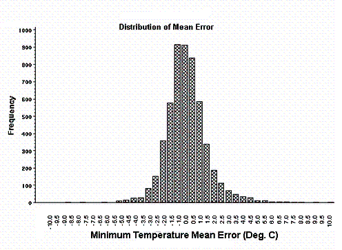
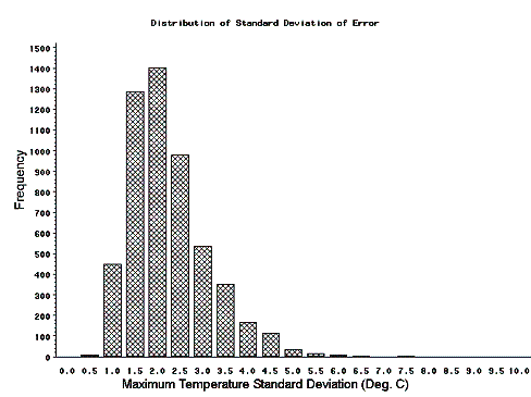
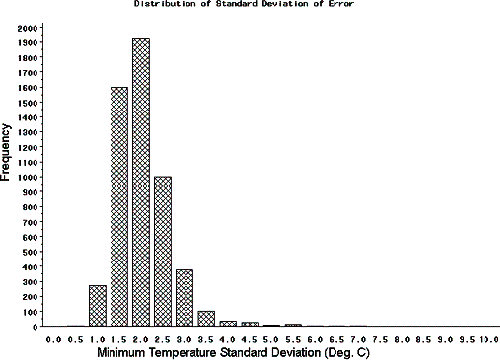
elevation. Figures 34 through 37 show the distribution of the mean
and standard deviation of the errors for maximum and minimum
temperatures.
The overall precision and bias of maximum (2.2 and 0.2 °C,
respectively) and minimum (2.0 and 0.1 °C, respectively)
temperatures are comparable to the results from the AWS and SMP
sections. Since the estimated bias increases with the elevation
difference, the bias can be remedied by correcting the temperature
for the elevation difference.
Table 32. Summary statistics of mean error for maximum and
minimum temperatures versus weather station elevation.
| Elevation |
Number of Sites |
Number of Days |
Error (Estimated-Measured), °C |
| Maximum Temperature |
Minimum Temperature |
| Mean |
Std. Dev. |
Mean |
Std. Dev. |
| 0-250 |
2168 |
2,214,330 |
-0.1 |
2.1 |
-0.1 |
1.9 |
| 250-500 |
1231 |
1,258,811 |
0 |
2.3 |
0 |
2.1 |
| 500-750 |
470 |
473,303 |
0.2 |
2.4 |
0.2 |
2.1 |
| 750-1000 |
316 |
326,772 |
0.2 |
2.3 |
0.2 |
2.0 |
| 1000-1250 |
267 |
276,052 |
0.4 |
2.3 |
0.3 |
2.0 |
| 1250-1500 |
312 |
325,627 |
0.2 |
2.3 |
0.1 |
2.1 |
| 1500-1750 |
213 |
219,487 |
0.6 |
2.4 |
0.6 |
2.3 |
| 1750-2000 |
162 |
166,121 |
0.9 |
2.3 |
0.5 |
2.4 |
| 2000-2250 |
107 |
106,261 |
1.4 |
2.2 |
0.9 |
2.4 |
| All Days |
5347 |
5,471,796 |
0.2 |
2.2 |
0.1 |
2.0 |

Figure 34. Bar chart. Distribution of
mean error for maximum temperature (NCDC data).

Figure 35. Bar chart. Distribution of
mean error for minimum temperature (NCDC data).

Figure 36. Bar chart. Distribution of
standard deviation of error for maximum temperature (NCDC
data).

Figure 37. Bar chart. Distribution of
standard deviation of error for minimum temperature (NCDC
data).
Correcting Temperature for Elevation
Difference
In this part of the study, maximum temperatures were corrected
for elevation differences and the results of the corrected and
uncorrected errors were compared. The LTPP AWS and SMP databases
were used for the study and the maximum temperature was corrected
using the following algorithm derived from the analysis of the
elevation differences in table 26:
- Temperature correction was applied to elevation differences
between 250 and 1000 m (higher and lower elevation
differences).
- For every 100-m increase in elevation, 0.75 °C was subtracted
from the temperature (0.75 °C was added for elevation decrease) as
Corrected Maximum Temperature = Maximum Temperature – Elevation
Difference (km) * 7.5 °C.
Table 33 includes the mean and standard deviation of error for
maximum temperature estimates using a simple average (corrected and
uncorrected). Table 34 includes the same data for SMP sections. In
both cases, correcting the maximum temperature dramatically reduced
the bias, while the standard deviation did not change
significantly.
Table 33. Summary statistics of error for AWS sections
(corrected for elevation).
| No. |
AWS
ID |
Days
of
Data |
Mean Error (AWS-Estimate), °C |
Standard Deviation Error, °C |
IMS
VWS |
No
Weight |
Corrected
No Weight |
IMS
VWS |
No
Weight |
Corrected
No Weight |
| 1 |
10101 |
686 |
-0.1 |
0 |
0 |
3.0 |
2.9 |
2.9 |
| 2 |
40100 |
606 |
5.0 |
4.1 |
3.2 |
1.3 |
1.5 |
1.6 |
| 3 |
40200 |
892 |
1.3 |
1.0 |
1.0 |
1.6 |
1.5 |
1.5 |
| 4 |
50113 |
601 |
0 |
-0.2 |
-0.2 |
3.2 |
3.1 |
3.1 |
| 5 |
80200 |
459 |
-0.4 |
-0.1 |
-0.1 |
5.8 |
2.7 |
2.7 |
| 6 |
100100 |
410 |
-0.2 |
-0.1 |
-0.1 |
2.6 |
2.3 |
2.3 |
| 7 |
120101 |
201 |
0.1 |
-0.3 |
-0.3 |
2.2 |
1.8 |
1.8 |
| 8 |
200100 |
147 |
-0.5 |
0.5 |
0.5 |
5.0 |
2.7 |
2.7 |
| 9 |
200200 |
146 |
0.5 |
-0.1 |
-0.1 |
2.8 |
3.3 |
3.3 |
| 10 |
300800 |
763 |
1.4 |
0.7 |
-1.5 |
2.5 |
2.7 |
2.7 |
| 11 |
310100 |
143 |
-0.4 |
0.1 |
0.1 |
4.1 |
2.4 |
2.4 |
| 12 |
320200 |
570 |
0.8 |
0.4 |
0.4 |
1.5 |
2.1 |
2.1 |
| 13 |
350101 |
458 |
-0.1 |
-0.3 |
-0.3 |
2.5 |
2.4 |
2.4 |
| 14 |
350801 |
142 |
0.3 |
0 |
-0.6 |
1.4 |
1.6 |
1.7 |
| 15 |
360800 |
403 |
0.6 |
0.5 |
0.2 |
2.3 |
2.7 |
2.7 |
| 16 |
370200 |
877 |
0 |
-0.2 |
-0.2 |
1.6 |
1.8 |
1.8 |
| 17 |
380200 |
402 |
0.5 |
0.4 |
0.4 |
4.1 |
1.6 |
1.6 |
| 18 |
390200 |
635 |
-0.4 |
0.1 |
0.1 |
4.3 |
3.2 |
3.2 |
| 19 |
460800 |
68 |
-0.2 |
-0.1 |
-0.1 |
1.6 |
1.6 |
1.6 |
| 20 |
480801 |
90 |
0.7 |
0.4 |
0.4 |
2.1 |
3.0 |
3.0 |
| 21 |
490800 |
43 |
2.3 |
2.3 |
2.3 |
2.3 |
2.4 |
2.4 |
| 22 |
510100 |
362 |
-0.3 |
-0.6 |
-0.6 |
4.5 |
3.7 |
3.7 |
| 23 |
530200 |
631 |
-0.6 |
0.2 |
0.2 |
3.1 |
2.1 |
2.1 |
| 24 |
530800 |
525 |
-0.4 |
-0.4 |
-0.4 |
3.7 |
2.9 |
2.9 |
| All Days |
10260 |
0.48 |
0.39 |
0.15 |
3.31 |
2.67 |
2.64 |
| Average Section |
427.5 |
0.41 |
0.35 |
0.18 |
2.88 |
2.42 |
2.43 |
Table 34. Summary statistics of error for SMP sections
(corrected for elevation).
| No. |
SMP
ID |
Days
of
Data |
Mean Error (Estimate-SMP), °C |
Standard Deviation Error, °C |
IMS
VWS |
No
Weight |
Corrected
No Weight |
IMS
VWS |
No
Weight |
Corrected
No Weight |
| 1 |
100102 |
335 |
0.4 |
0.4 |
0.4 |
2.5 |
2.3 |
2.3 |
| 2 |
131005 |
395 |
-0.3 |
0 |
0 |
2.7 |
2.3 |
2.3 |
| 3 |
131031 |
342 |
-0.1 |
-0.4 |
-3.5 |
3.4 |
2.6 |
2.6 |
| 4 |
133019 |
353 |
0.3 |
0.2 |
0.2 |
3.3 |
2.6 |
2.6 |
| 5 |
161010 |
518 |
1.4 |
1.3 |
1.3 |
1.9 |
2.2 |
2.2 |
| 6 |
183002 |
287 |
1.4 |
1.4 |
1.4 |
3.6 |
3.3 |
3.3 |
| 7 |
204054 |
302 |
1.4 |
0.7 |
0.7 |
3.3 |
4 |
4 |
| 8 |
231026 |
627 |
0.4 |
0.5 |
0.5 |
2.9 |
3.1 |
3.1 |
| 9 |
241634 |
502 |
1.3 |
1.1 |
1.1 |
1.6 |
1.8 |
1.8 |
| 10 |
251002 |
569 |
-0.2 |
-0.3 |
-0.4 |
3.3 |
3.4 |
3.4 |
| 11 |
271018 |
898 |
1.4 |
0.3 |
0.3 |
3.2 |
2.8 |
2.8 |
| 12 |
271028 |
1057 |
0.9 |
0.8 |
0.8 |
2.5 |
2.8 |
2.8 |
| 13 |
274040 |
727 |
0.8 |
0.7 |
0.7 |
4.4 |
3.4 |
3.4 |
| 14 |
276251 |
979 |
-0.6 |
-0.5 |
-0.5 |
4.3 |
3.5 |
3.5 |
| 15 |
281016 |
457 |
0.1 |
0.1 |
0.1 |
3.2 |
2.3 |
2.3 |
| 16 |
281802 |
410 |
-1.1 |
-1 |
-1 |
2.1 |
2.6 |
2.6 |
| 17 |
308129 |
692 |
0.9 |
0.6 |
0.6 |
2.9 |
2.9 |
2.9 |
| 18 |
310114 |
309 |
0.6 |
1.2 |
1.2 |
4.7 |
2.8 |
2.8 |
| 19 |
313018 |
313 |
0.6 |
1.1 |
1.1 |
5.7 |
3.6 |
3.6 |
| 20 |
320204 |
52 |
0.2 |
0 |
0 |
1.9 |
2 |
2 |
| 21 |
331001 |
624 |
0.5 |
0.2 |
0.2 |
0.7 |
2.2 |
2.2 |
| 22 |
351112 |
356 |
0.9 |
1.4 |
1.4 |
1.6 |
1.4 |
1.4 |
| 23 |
360801 |
355 |
1.2 |
1.1 |
1.1 |
2.5 |
2.8 |
2.8 |
| 24 |
364018 |
636 |
0.2 |
0 |
-1.7 |
3.3 |
2.7 |
2.7 |
| 25 |
371028 |
464 |
0 |
-0.2 |
-0.2 |
1.8 |
2 |
2 |
| 26 |
404165 |
495 |
0.9 |
1.2 |
1.2 |
3.8 |
2.7 |
2.7 |
| 27 |
421606 |
362 |
0 |
0 |
0 |
2 |
3 |
3 |
| 28 |
460804 |
406 |
0.5 |
0.5 |
0.5 |
1.7 |
1.7 |
1.7 |
| 29 |
469187 |
342 |
0.2 |
0.4 |
0.4 |
3.5 |
3.5 |
3.5 |
| 30 |
481060 |
577 |
0.9 |
0.9 |
0.9 |
1.4 |
1.4 |
1.4 |
| 31 |
481068 |
583 |
-0.4 |
-0.3 |
-0.3 |
4 |
3.9 |
3.9 |
| 32 |
481077 |
605 |
0 |
0.2 |
0.2 |
2.8 |
2.8 |
2.8 |
| 33 |
481122 |
535 |
0 |
-0.2 |
-0.2 |
3.1 |
2.2 |
2.2 |
| 34 |
483739 |
601 |
-0.5 |
-0.6 |
-0.6 |
3 |
2.9 |
2.9 |
| 35 |
484142 |
611 |
-1.2 |
-0.5 |
-0.5 |
4.1 |
3.3 |
3.3 |
| 36 |
484143 |
447 |
0.6 |
0.5 |
0.5 |
4.1 |
3.5 |
3.5 |
| 37 |
491001 |
536 |
0.2 |
0 |
-0.9 |
1.4 |
1.6 |
1.6 |
| 38 |
493011 |
603 |
1.6 |
0.9 |
0.9 |
2.1 |
1.9 |
1.9 |
| 39 |
501002 |
597 |
-0.5 |
0 |
-0.8 |
3 |
2.2 |
2.2 |
| 40 |
510114 |
266 |
0.8 |
0.4 |
0.4 |
4.3 |
3.5 |
3.5 |
| 41 |
533813 |
356 |
0.8 |
0.2 |
0.2 |
3 |
2.2 |
2.2 |
| 42 |
561007 |
588 |
0.5 |
0.3 |
0.3 |
4 |
4.1 |
4.1 |
| 43 |
831801 |
973 |
0 |
0 |
0 |
1.3 |
1.2 |
1.2 |
| 44 |
833802 |
575 |
-0.2 |
0.1 |
0.1 |
1.4 |
1.3 |
1.3 |
| 45 |
871622 |
581 |
0.2 |
0.3 |
0.3 |
1.3 |
1.2 |
1.2 |
| 46 |
893015 |
782 |
0.2 |
0.5 |
0.5 |
1.6 |
1.4 |
1.4 |
| 47 |
906405 |
605 |
0.2 |
0.1 |
0.1 |
1.7 |
1.7 |
1.7 |
| All Days |
24585 |
0.35 |
0.3 |
0.17 |
3.02 |
2.7 |
2.76 |
| Average Section |
523.1 |
0.37 |
0.33 |
0.19 |
2.81 |
2.57 |
2.57 |
Comparing Climatic Estimates from
NCDC Data
Estimated climatic data were developed for NCDC weather station
sites and were then compared to the measured NCDC data. Climatic
estimates were developed by averaging data for the five closest
weather stations for each NCDC site without using a weight. Table
35 includes the overall average and standard deviation of error
(measured minus estimated) for the daily, monthly, and yearly
climatic estimates of 5347 NCDC sites throughout the United States.
The data period covers 1994 through 1996 and included 1096 days of
data for each site. The following are some observations from the
results:
- Using a simple average of data from the five closest weather
stations, maximum and minimum daily temperatures can be estimated
within 2.2 °C.
- Monthly minimum and maximum temperatures can be estimated
within 0.7 °C.
- Yearly minimum and maximum temperatures can be estimated within
0.6 °C.
- Monthly and yearly precipitation can be estimated within 29 mm
and 147 mm, respectively.
- Yearly FI can be estimated within 56 °C-days.
These statistics were calculated using all observations and are
overall values. The overall values are generally higher than the
average per section values, especially for accumulated data such as
precipitation and FI. This is caused by the effect of bias on the
standard deviation (locations with a high bias will contribute more
to the standard deviation).
Table 35. Overall mean and standard deviation of error of
daily, monthly, and yearly estimates for NCDC sites.
| Parameter |
Period |
Frequency |
Error (Estimated-Measured) |
| Mean |
Std. Dev. |
| Maximum Temperature,
°C |
Daily |
5,471,796 |
0.1 |
2 |
| Monthly |
178,840 |
0 |
0.7 |
| Yearly |
15,631 |
0 |
0.6 |
| Minimum Temperature,
°C |
Daily |
5,471,796 |
0.2 |
2.2 |
| Monthly |
175,411 |
0 |
0.7 |
| Yearly |
15,622 |
0 |
0.6 |
| Precipitation, mm |
Monthly |
235,286 |
-3.4 |
28.6 |
| Yearly |
22,929 |
-35 |
147.3 |
| Yearly Freezing Index, °C |
Yearly |
23,969 |
-17.5 |
55.8 |
