U.S. Department of Transportation
Federal Highway Administration
1200 New Jersey Avenue, SE
Washington, DC 20590
202-366-4000
Federal Highway Administration Research and Technology
Coordinating, Developing, and Delivering Highway Transportation Innovations
 |
| This report is an archived publication and may contain dated technical, contact, and link information |
|
Publication Number: FHWA-RD-03-093
Date: August 2006 |
|
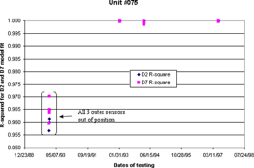
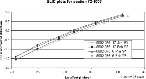
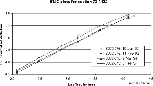
Study of Long-Term Pavement Performance (LTPP): Pavement DeflectionsAppendix H. FWD SN 075, January 17, 1990–January 22, 1990These previously reported sensor position errors were located in the database and also identified and analyzed using an automated screening version of SLIC. The SLIC screening versions used were tailored for predicting the position of sensors 2 and 7. Since in this case three of the sensors were positioned differently from protocol, the overall SLIC regression fit was mainly used to verify the positioning errors found. The first graph shown in this appendix (figure 35) is a plot of all the SN #075 values of R2 for the d2 and d7 regression fits from 1990 through 1997, for lane 1, drop height 4 FWD tests. In figure 35, it can be seen that there is a serious anomaly starting when SN #075 was first used, presumably on January 17, 1990. The average R2 value during the period of time in question was only 0.963, whereas when the FWD sensors used in the regression are correctly placed, the regression fit is generally 0.998 or better. Clearly the R2 values change dramatically for the better after the period of time in question. Individual plots like those shown in the succeeding two graphs corroborate that the reported protocol configuration was incorrect. Based on a detailed analysis of the data, for example as shown in figures 36 and 37, it is clear that the sensor positions used were 0, 8, 12, 18, 30, 42, and 66 inches. Both section-specific plots depict these sensor positions, with d5, d6, and d7 shifted 6 inches farther from the plate, probably due to one minor and inadvertent error in the distance measurement between sensors 4 and 5. Alternatively, the distance to these sensors may have been inadvertently measured from the edge of the loading plate rather than from the center of the plate where sensor 1 is located. In figures 36 and 37, the gray lines and data points are plots of both actual and erroneous data for d5, d6, and d7 for the particular date. The gray lines that are parallel to the rest of the data are the correct plots, with d5, d6, and d7 set to 76.2 cm (30 inches), 106.7 cm (42 inches) and 167.6 cm (66 inches), respectively. Because of this information, and the previous information supplied to FHWA, it can be concluded with certainty that d5, d6, and d7 were not positioned in their protocol positions; rather, they were positioned at 76.2 cm (30 inches), 106.7 cm (42 inches) and 167.6 cm (66 inches), respectively (or very close to these positions), on FWD SN #075 between January 17, 1990, and January 22, 1990. These dates correspond to the dates when lane 1 tests were conducted at drop height 4. This period of time may need to be extended slightly if other tests were conducted along different lanes or at different drop heights. In any case, FWD tests conducted on or after February 9, 1990, indicate protocol sensor positions. FWD SN #075 was first used for lane 1, drop height 4 tests on January 17, 1990; it is also possible that it was used prior to this date, if different lanes or drop heights were used for LTPP testing (excluding the lane 1, drop height 4 test sequence).
Figure 35. Graph. R2 model for d2 and d7 predictions, unit #075, 1990–97.
Figure 36. Graph. SLIC plots for section 72–1003 including unit #075, January 1990.
Figure 37. Graph. SLIC plots for section 72–4122 including unit #075, January 1990.
|