U.S. Department of Transportation
Federal Highway Administration
1200 New Jersey Avenue, SE
Washington, DC 20590
202-366-4000
Federal Highway Administration Research and Technology
Coordinating, Developing, and Delivering Highway Transportation Innovations
 |
| This report is an archived publication and may contain dated technical, contact, and link information |
|
Publication Number: FHWA-HRT-08-056 Date: November 2008 |
The rod and level can be used to accurately measure the profile of a pavement. These data can be used to evaluate roughness of a pavement by computing a roughness index such as the IRI. In computing roughness indices, only relative elevations and not absolute elevations are needed. The guidelines in this section can be applied to conventional survey equipment such as an optical level and graduated staff, which requires readings to be manually recorded, as well as automated equipment that are capable of automatically storing measured data.
Detailed scheduling and traffic control at test sites must be coordinated by the RSC. However, all traffic control activities at test sites will be performed by personnel from either the State or provincial highway agency. Layout of the test site should not be undertaken until all applicable traffic control devices are in place.
The rod and level used in routine surveying and road construction will generally not have the resolution needed for pavement profile measurements. Precision leveling instruments are required for pavement profile measurements. Instruments used for profile measurement should satisfy resolution criterion given in table 2, which was obtained from the ASTM Standard on Measuring Road Roughness by Static Level.(14)
| IRI Range (m/km) | Resolution (mm) |
| 0 = IRI < 0.5 | 0.125 |
| 0.5 = IRI < 1.0 | 0.25 |
| 1.0 = IRI < 3.0 | 0.5 |
| 3.0 = IRI < 5.0 | 1.0 |
| 5.0 = IRI < 7.0 | 1.5 |
| IRI = 7.0 | 2.0 |
The rod used should be equipped with a bubble level so that it can be accurately held vertically. A suitable base may be selected for the rod in order to reduce sensitivity to small variations in rod placement. For smooth textured pavements, any type of base is suitable. For textured surfaces, a circular pad with a diameter of at least 20 mm is recommended.(14) As only relative elevations are required for computing roughness indices, no correction is required if a pad is attached to the bottom of a rod.
The operator is responsible for forwarding all data collected during testing to the RSC.
In event of an accident, the operator will inform the RSC of incident as soon as practical after the mishap. Details of the event shall subsequently be reported in writing to the RSC to assist in any insurance claim procedures.
The following sequences of fieldwork tasks are required:
To measure the pavement profile using a rod and level, two persons are needed. One person is needed to hold rod (rod person) and another to operate the level and take readings (instrument operator). If the level is not capable of automatically recording readings, having an additional person to record readings (record keeper) will make the process quicker.
According to the ASTM Standard on Measuring Road Roughness by Static Level,(14) an experienced crew of three would require less than 10 seconds to obtain one reading. This involves positioning the rod by the rod person, reading the level by the instrument operator, and recording the measurements by the record keeper.
The two wheel paths in the outside travel lane should be marked using the following procedure:
Measurements have to be taken along the wheel paths at 0.3 m intervals. The locations at which readings are to be taken can be determined by either of the following methods:
The first reading taken after the level is set up is referred to as a backsight, while the last reading taken at that setup before the level is moved is referred to as a foresight. Other readings taken in between a backsight and a foresight are referred to as intermediate sights. The procedure to be followed for measuring longitudinal profile is as follows:
The measurement of pavement profiles using a rod and level is labor intensive and time consuming. Therefore, it is advisable to check the accuracy of measured data at regular intervals. This can be performed by establishing a set of control points along the wheel path, for example at 30-m intervals starting from the beginning of the section. After leveling a distance of 30 m, the rod has to be placed at the previous control point and another reading must be taken. This reading has to agree with the previous reading taken at this control point within resolution of the instrument. If readings do not agree, the distance between the control points has to be measured again. This procedure can be used if instrument setup is not changed between two control points being considered. If instrument setup is changed between two control points, the above procedure can still be applied by treating the pivot point as a control point.
The following factors have to be considered when performing profile measurements with rod and level:
During profile measurements in the field, the crew is only expected to record the readings of the level using procedures described in section 4.3.3. Computation of the elevation profile from these data will be done in the office. This section briefly describes how data recorded in field are used to obtain longitudinal profile of pavement.
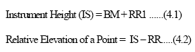
For profile computations, the elevation of the location where the first reading (first backsight) was measured is needed. However, as only relative elevations are needed to compute roughness indices (such as IRI), an arbitrary value can be selected for the elevation of this point. Relative elevation of any point measured from initial instrument setup can be obtained from the following equations:
 (1)
(1)
Where:
IS = Initial instrument height,
BM = Elevation of point where first backsight was taken (assume any value e.g. 30 m),
RR1 = Rod reading at first backsight, and
RR = Rod reading at any point from initial instrument setup.
Once position of level is changed, instrument height will also change. New instrument height can be obtained from the following equation:
![]() (2)
(2)
Where:
Nht = New instrument height,
Oht = OLd instrument height,
BS = Backsight at pivot point, and
FS = Foresight at pivot point.
The relative elevation of the points measured from this new instrument location can be determined by using equation 4.2 and using new the instrument height (Nht) instead of IS.
A quality control check must be performed in the field to ensure that no movement of the level took place during current setup of the level. This check must be performed every time before the level is moved and when the end of the test section is reached. Once the last reading at the current location of the level has been taken, before moving the level, place the rod at the location at which the first reading was taken with the current setup of the level, and take a reading. Both readings have to agree within resolution of the instrument. This check can also be performed at regular intervals by establishing a set of control points as described in section 4.3.3.
The user manual of the level should be consulted about how to perform adjustments to the instrument. Different makes and models of levels will require different adjustments. The user manual should be consulted to determine if the following adjustments are needed for the level being used and, if so, how to perform the specific adjustment. The following are some common adjustments that are required in levels in order to obtain accurate measurements:
The rod has to be checked to verify the accuracy of the markings. A standardized tape should be used for this.
Shockproof packaging should be used when transporting the instrument. Always clean the instrument after measurements are completed. Before cleaning the lenses, blow dust off the lenses, then clean the lenses using a soft cloth. Lenses should not be touched with fingers. If the instrument becomes wet in the field, make sure that it is completely dry before packing. The tripod should be inspected regularly to ensure that the connections are not loose.
The Rod and Level Data Collection form (see appendix F) should be used to record readings when profile measurements are performed using a rod and level. A comment should be made on this form as to how the wheel paths were located. All items in this form should be completed by the instrument operator or record keeper. Location information in this form should be completed even when an automated instrument that is capable of saving data is used.
Backup copies of the Rod and level Data Sheets must be made without exception as soon as possible. A minimum of two copies must be made for each data sheet. One copy should be transmitted by mail to the RSC office, while the second copy should be retained by the operator in case first copy is lost in mail.
| << Previous | Contents | Next >> |

