U.S. Department of Transportation
Federal Highway Administration
1200 New Jersey Avenue, SE
Washington, DC 20590
202-366-4000
Federal Highway Administration Research and Technology
Coordinating, Developing, and Delivering Highway Transportation Innovations
 |
| This report is an archived publication and may contain dated technical, contact, and link information |
|
Publication Number: FHWA-RD-03-088 Date: November 2003 |
During the early 1980s, the Transportation Research Board (TRB) of the National Research Council, under the sponsorship of the Federal Highway Administration (FHWA) and with the cooperation of the American Association of State Highway and Transportation Officials (AASHTO), undertook a Strategic Transportation Research Study (STRS) of the deterioration of the Nation's highway and bridge infrastructure system. The study recommended that a Strategic Highway Research Program (SHRP) be initiated to focus research and development activities on improving highway transportation. The study report, published in 1984 as TRB Special Report 202, America's Highways, Accelerating the Search for Innovation, recommended six strategic research areas. The Long-Term Pavement Performance (LTPP) program was one of these areas. During 1985 and 1986, independent contractors developed detailed research plans for SHRP. The detailed research plans were published in May 1986 as a TRB report entitled Strategic Highway Research Program-Research Plans.
The LTPP program was envisioned as a comprehensive program to satisfy a wide range of pavement information needs. It draws on technical knowledge of pavements currently available and seeks to develop models that will better explain how pavements perform. It also seeks to gain knowledge of the specific effects on pavement performance of various design features, traffic and environment, materials, construction quality, and maintenance practices. As sufficient data become available, analyses are conducted to provide better performance prediction models for use in pavement design and management; better understanding of the effects of many variables on pavement performance; and new techniques for pavement design, construction, and rehabilitation.
The strategy behind the LTPP program represents a significant shift in the traditional research approach. Traditionally, pavement performance research was divided into specific topics of limited scope and duration, which started with data collection and ended with recommendations based on analysis of the collected data. To overcome some of the challenges posed by the study of pavement behavior in short-term efforts, the LTPP program was established as a long-term national effort. Under the LTPP paradigm, data collection is conducted in advance of the development of many specific data analysis objectives. Since individuals not involved in data collection operations conduct many of the important data analyses, the LTPP program has invested in the development of a publicly accessible database and database use tools.
The overall objective of the LTPP program is to assess long-term performance of pavements under various loading and environmental conditions over a period of 20 years. The specific objectives for the LTPP program are:
The LTPP program is a study of the behavior of in-service pavement sections. These pavement sections have been constructed using highway agency specifications and contractors, and subjected to real-life traffic loading. These in-service pavement sections are classified in the LTPP program as General Pavement Studies (GPS) and Specific Pavement Studies (SPS). GPS consist of a series of studies on nearly 800 in-service pavement test sections throughout the United States and Canada. SPS are intensive studies of specific variables involving new construction, maintenance treatments, and rehabilitation activities.
To provide a logical basis for test section designations, a broad-based experimental approach has been used. Test sections are classified as GPS or SPS. The fundamental difference between these two classifications is that at the start of the LTPP program, the GPS test sections are existing pavements and the SPS projects are sites where multiple test sections of differing experimental treatment factors are constructed. When a GPS or SPS test section is rehabilitated, it can be assigned to a GPS rehabilitation designation.
While the LTPP test section classification methodology is based on experimental concepts, data users are encouraged to develop their own classification methods to meet specific analytical objectives. For example, the SPS-1 experiment is designed to extend the findings from the GPS-1 and -2 studies.
In the published literature, the LTPP projects are designated by experiment designs. A factorial combination approach has been used for the development of the experiment design designation of each GPS and SPS experiment. This approach requires the identification of significant pavement and environmental/loading factors considered to have an influence on pavement performance. Pavement factors include such variables as layer thickness, base type, base thickness, joint spacing, and percent steel reinforcement, which are varied as appropriate for the pavement type being studied. Environmental/loading factors include moisture (wet/dry), temperature (freeze/no-freeze), subgrade classification (fine/coarse grained), and traffic loading rate (low/high).
The combination of these selected factors form an experimental factorial that is used as the sampling basis for test sections included in each study. Within GPS, these factorials are more properly considered as sampling templates used in the selection of pavement structures included in the studies. Since GPS consists mostly of pavements that were constructed and in service prior to the start of the LTPP program, it is impossible to find pavements with all of the combinations defined within the factorial. SPS is a more controlled experiment requiring construction of the specified pavement structures. While the SPS experimental factorials are closer to a classical experiment design, between-site construction deviations should be considered in many types of statistical analyses.
The GPS program is a series of studies on selected in-service pavements structured to develop a comprehensive national pavement performance database. These studies are restricted to pavements that incorporate materials and designs representing good engineering practices and that have strategic future importance. Because of the nationwide thrust of the program, the studies are limited to pavement structures in common use across the United States.
The GPS test sections are located on pavement structures constructed up to 15 years prior to the start of the LTPP program. Although detailed research-level measurements on these pavements during the early years of their lives are not available, the GPS test sections offer the potential for development of earlier results than those possible from newly constructed test sections. As the SPS test sections are rehabilitated, they are reclassified into the GPS experiment designations. Table 1 provides a list of the titles of each of the experiments. A more comprehensive definition is provided in appendix B.
It should be noted that the proposed GPS-8 study of bonded portland cement concrete (PCC) overlays on PCC pavements was not pursued because of lack of an adequate number of nominated in-service projects. An SPS study on bonded PCC overlays, SPS-7 , was formulated to address this type of rehabilitation alternative.
The SPS program is a long-term study of specially constructed, maintained, or rehabilitated pavement sections incorporating a controlled set of experiment design and construction features. The objective of SPS is to provide a more detailed and complete base of data to extend and refine the results obtained from the GPS studies. The SPS program incorporates nine studies grouped into the five categories as illustrated by table 2. Appendix B provides a more complete definition of each of the experiments.
Essentially, the SPS program involves monitoring newly constructed sections or existing pavement sections subjected to maintenance or rehabilitation treatments. Each SPS experiment requires construction of multiple test sections at each site. The number of test sections may range from two for SPS-8 to twelve for SPS-1 and -2 . In addition, a highway agency may construct supplemental test sections on an SPS site to investigate other factors of interest to the agency. The following definitions apply only to the core sections within each experiment. The supplemental sections that may have been constructed by a highway agency are based on the respective agency's research interests and are typically not consistent among highway agencies.
Table 1. List of GPS experiments.
|
Experiment |
Experiment Title |
|---|---|
|
GPS-1 |
Asphalt Concrete (AC) Pavement on Granular Base |
|
GPS-2 |
AC Pavement on Bound Base |
|
GPS-3 |
Jointed Plain Concrete Pavement (JPCP) |
|
GPS-4 |
Jointed Reinforced Concrete Pavement (JRCP) |
|
GPS-5 |
Continuously Reinforced Concrete Pavement (CRCP) |
|
GPS-6A |
Existing AC Overlay of AC Pavement (existing at the start of the program) |
|
GPS-6B |
AC Overlay Using Conventional Asphalt of AC Pavement-No Milling |
|
GPS-6C |
AC Overlay Using Modified Asphalt of AC Pavement-No Milling |
|
GPS-6D |
AC Overlay on Previously Overlaid AC Pavement Using Conventional Asphalt |
|
GPS-6S |
AC Overlay of Milled AC Pavement Using Conventional or Modified Asphalt |
|
GPS-7A |
Existing AC Overlay on PCC Pavement |
|
GPS-7B |
AC Overlay Using Conventional Asphalt on PCC Pavement |
|
GPS-7C |
AC Overlay Using Modified Asphalt on PCC Pavement |
|
GPS-7D |
AC Overlay on Previously Overlaid PCC Pavement Using Conventional Asphalt |
|
GPS-7F |
AC Overlay Using Conventional or Modified Asphalt on Fractured PCC Pavement |
|
GPS-7R |
Concrete Pavement Restoration Treatments With No Overlay |
|
GPS-7S |
Second AC Overlay, Which Includes Milling or Geotextile Application, on PCC Pavement With Previous AC Overlay |
|
GPS-9 |
Unbonded PCC Overlay on PCC Pavement |
Table 2. List of SPS experiments by category .
|
Category |
Experiment |
Title |
|---|---|---|
|
Pavement Structural Factors |
SPS-1 |
Strategic Study of Structural Factors for Flexible Pavements |
|
SPS-2 |
Strategic Study of Structural Factors for Rigid Pavements |
|
|
Pavement Maintenance |
SPS-3 |
Preventive Maintenance Effectiveness of Flexible Pavements |
|
SPS-4 |
Preventive Maintenance Effectiveness of Rigid Pavements |
|
|
Pavement Rehabilitation |
SPS-5 |
Rehabilitation of AC Pavements |
|
SPS-6 |
Rehabilitation of Jointed Portland Cement Concrete (JPCC) Pavements |
|
|
SPS-7 |
Bonded PCC Overlays of Concrete Pavements |
|
|
Environmental Effects |
SPS-8 |
Study of Environmental Effects in the Absence of Heavy Loads |
|
Asphalt Aggregate Mixture Specifications |
SPS-9P |
Validation and Refinements of Superpave®Asphalt Specifications and Mix Design Process |
|
SPS-9A |
Superpave Asphalt Binder Study |
Generally, each GPS and SPS test section consists of a 152-meter (m) (500-foot (ft)) monitoring portion with a 15.2-m (50-ft) materials sampling section at each end. On GPS test sections, a maintenance control zone, extending 152 m (500 ft) in front of and 76 m (250 ft) beyond the limits of the monitoring section, has been established around each test section as illustrated in figure 1. Since SPS projects consist of multiple test sections constructed for a single project, the maintenance control zone is extended to cover groups of adjoining sections as illustrated in figure 2.
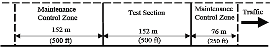
Figure 1. Layout of a generic GPS test section.

Figure 2. Example layout of a generic SPS project.
The exceptions to the 152-m (500-ft-) long test section include the crack-and-seat test sections in the SPS-6 experiment and some agency supplemental sections constructed on SPS projects. The crack-and-seat sections on SPS-6 are 305-m (1,000-ft) long, while agency supplemental sections have been constructed both shorter and longer than the 152-m (500-ft) standard section.
The LTPP program uses a test section and project station location convention . The test section station convention is based on the staring point of the monitoring portion of the section being assigned a station of 0. The longitudinal locations in the direction of traffic are assigned positive stations. When the LTPP program was started, longitudinal locations were designated using U.S. customary units of 100-ft (30.5-m) stations. However, in the database, longitudinal locations are converted to metric meter stations. Thus, the original 5+00 test section station painted on the pavement surface is represented as 152 m in the POINT_LOC field in the database. (Note: For data users reviewing film or video of LTPP test sections, painted white cross markings are located at 30.5-m (100-ft) intervals.) The project station location convention applies to SPS project sites where more than one test section is located.
|
LTPP Database Tip! |
The database has not been completely converted to metric units. Some of the modules are in the International System of Units (SI) and some are still in the U.S. customary units. The units for every data element are stored in the LTPP data dictionary (LTPPDD) table. Units should be checked to ensure that calculations are performed with consistent units. |
A project station location convention is used where multiple test sections are located on the same SPS project site. The project station convention starts with station 0 assigned to the first test section located at the project site in the direction of travel. The SECTION_START and SECTION_END fields in the SPS_PROJECT_STATIONS table contain project station location information.
|
LTPP Database Tip! |
The SPS_PROJECT_STATIONS table can be used as a link table to associate both GPS and SPS test sections co-located at an SPS project site. In this table, the TEST_SECTION field contains a joined STATE_CODE+SHRP_ID that can be used to identify specific test sections. |
The overriding philosophy of sampling and monitoring measurements on LTPP test sections is to not permit destructive testing or sampling within the monitoring portion of the section.
A list of LTPP operational documents is presented in appendix A. These documents provide details on all of the LTPP data collection activities stored in the LTPP database.

