U.S. Department of Transportation
Federal Highway Administration
1200 New Jersey Avenue, SE
Washington, DC 20590
202-366-4000
Federal Highway Administration Research and Technology
Coordinating, Developing, and Delivering Highway Transportation Innovations
 |
| This report is an archived publication and may contain dated technical, contact, and link information |
|
Publication Number: FHWA-HRT-04-109
Date: September 2004 |
University: Pennsylvania State University (PSU)
Name of University Researchers Preparing Report: Paul G. Knight and Brian B. Ayers
NWS WFO: State College, PA
Name of Primary NWS Collaborator: David Ondrejik
DOT Office: Pennsylvania Department of Transportation (PennDOT)
Name of Primary DOT Collaborators: Alfred Uzowke, and formerly Douglas Schmitt
Cooperative Project, UCAR Award No. S01-32792
The original proposal called for collaboration between PennDOT, the NWS WFO for Central Pennsylvania, and the State Climate Office at Pennsylvania State University. The plan had several components, including assuring the quality of and validating the Roadway Weather Information System (RWIS) network, training PennDOT roadway weather managers, incorporating the RWIS data into both NWS forecasts and warnings, developing a mesoscale climatology, and testing the utility of RWIS data to enhance initial conditions for regional mesoscale models. Many of these goals were met. A few unplanned projects developed, specifically the design of a metadata system for the fledgling mesonet. The final goal of the project was not addressed for several reasons that will be discussed in the recommendation section.
The final project had four focal points. The first was to integrate the various data sets into a cohesive mesonet and to create methods to easily retrieve archived mesonet data. The second was to incorporate quality controlled RWIS data into the local NWS forecasts and the State Climate Office database. In the process of tackling the first two tasks, it became clear that the RWIS and COPAMS sites lacked important station information, and so a third task was added to create this station metadata. The NWS and State Climate Office staff trained PennDOT roadway weather managers in the final task. Each of the main components of the project is described in more detail below.
One of the main accomplishments of this project was the construction of a network of hourly weather reporting sites across Pennsylvania. These sites include:
All reporting stations measure hourly temperature, wind direction, and wind speed. In addition, the Climate Office is incorporating the State's approximately 200 hourly precipitation gauges of the Integrated Flood Observing and Warning System (I-FLOWS) in the network (see figure 1). When the NWS cooperative weather stations' (about 125 sites) daily submissions are included with their reports of maximum temperature, minimum temperature, and 24-hour precipitation, the network will provide more than 300 daily observations for the Commonwealth of Pennsylvania.
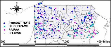 |
| Figure 1. Stations included in the Pennsylvania mesonet. |
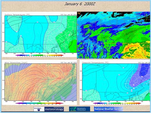
These reports are being stored in a MySQL database and are processed each hour for real-time display (http://pasc.met.psu.edu/MESONET) of weather-derived parameters, including wind streamlines, temperatures (see figure 2), dewpoint contours, and time series displays from each site. The streamlines are overlaid on a topographic map to discern channeling and air motions over the complex mountain-valley system of the State.
Assembling data from a range of agencies to serve the function of a meteorological mesonet presented challenges in handling differing data formats that were a function of different priorities for the meteorological parameters measured within each individual network. These factors are related to the primary purpose of the stations within each individual network.
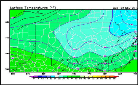 |
| Figure 2. Contours of isotherms (temperature lines). |
Another complicating factor was the fact that, in an effort to maximize the benefit of competition in the RWIS market, PennDOT selected three different manufacturers to provide, install, and maintain 82 RWIS stations along various highways across the State. All three types serve the primary objective to monitor roadway surface conditions and secondarily to monitor atmospheric conditions. Most of the sensors that are used on an ASOS are also present on the RWIS stations. However, variables vital to a surface weather observation mesonet, such as air pressure and rainfall accumulation, are not available from these 82 hourly stations. Nonetheless, the absence of these two parameters is compensated by an abundance of roadway surface and subsurface parameters, such as temperature, condition of ground (snow cover, icy, wet), and average speed of vehicles. The data can be applied to conduct research on the effects of adverse weather on public transportation. This large volume of information obtained from each RWIS observation (and the proprietary nature of the output by each RWIS manufacturer), such as number of highway lanes at each station, units of visibility, wind variables, and methods of reporting weather phenomena, lead to three varying formats of data output within this single network.
Ground-based network connections and limited server capacities also posed a serious challenge for including the RWIS data into the mesonet. In addition, irregular polling times complicated the development of an automated quality control system.
Another aim of the project was the inclusion of near real-time RWIS and other mesonet data sets into the NWS AWIPS1 data display and the Pennsylvania State Climate Office database. This initially required both management and quality control of the data feed. After deciphering the unique formats from each data source, Perl scripts were written to transfer the data from a flat file into a MySQL relational database on an hourly and even half-hourly basis. Most recent efforts have focused on access to RWIS five-minute data streams.
One issue that arose was determining which parameters to collect from the different networks. First, it was necessary to confirm the routine collection of the parameter by all of the instruments within a network. This allowed for an adequate spatial representation of the data across Pennsylvania and provided enough of a database to perform quality control using neighboring sites within the network. For a parameter to be chosen, it needed to augment general surface observations, climatology, forecast verification, modeling, or the welfare of the general public. Nineteen parameters met these criteria (see table 2) and are collected in the database as frequently as available to the State Climate Office.
| Weather | Wind Direction | Accumulated Precipitation | Roadway Surface Temperature |
|---|---|---|---|
| Temperature | Wind speed | Precipitation rate | Roadway surface conditions |
| Dewpoint | Wind gust | Snow depth | Roadway average speed |
| Relative humidity | Ceiling | Cloud cover | Subgrade (at 17 inches or 43.2 centimeter- depth) temperature |
| Air pressure | Visibility | Solar radiation |
Data flow quality proved more challenging than expected. The primary difficulty was the means of communication of the data from the sensor to a central location. The observations taken at the COPAMS and RWIS sites use external modems to communicate with their respective control centers, leading to delays in the observations. COPAMS reports arrive 90 minutes after the observation is taken, and the RWIS stations average a 30-minute to 1-hour delay depending on the time the call was made. This hampers production of real-time products that are useful in "nowcasting" hazardous weather and highway conditions. It also prevents many reports from being included in the AWIPS Statewide surface analysis fields. Another drawback to using modems and traditional telephone lines is their lack of reliability in hazardous conditions when the observations are in highest demand.
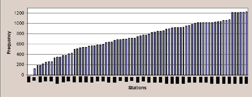
Yet another challenge of the RWIS network was that each of the three manufacturers transmits their data through a different method to a central computer at PennDOT. Adding this link between the observing station and the State Climate Office database increases the risk of communication failure. Figure 3 shows the large difference in the number of observations taken by each RWIS station during a late autumn month. More than 750 observations indicate approximately one report per hour during that 30-day period. The uncertainty of the frequency and timing of RWIS observations curtailed attempts to refine mesoscale model initial conditions based on RWIS reports.
 |
|
Figure 3. Frequency of observations taken by RWIS network during 1 month. The horizontal axis represents one vertical bar per RWIS station. |
Another data flow issue is the RWIS stations' reliability during the seasons when PennDOT has less of a need for frequent observations. A gradual increase in the number of reporting stations and frequency of reports was noticed from the summer of 2001 through late winter 2003, at which time nearly 82 stations were regularly reporting data.
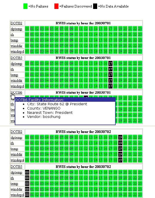
After the data flow issues were addressed, a quality control system was designed to the same standards as the Oklahoma mesonet. A conversion to netCDF was undertaken to facilitate storing all RWIS data and help retrieve archived mesonet data sets. The RWIS conversion was completed during the late autumn 2003. A robust quality assurance of the RWIS data is under development with a user-friendly interface being tested for both internal and external users. Figure 4 shows an early example of the quality assurance interface.
 |
|
Figure 4. Early example of a quality assurance report on RWIS data. Clicking on the station designation provides facility details. |
In addition to these issues, there are still concerns about instrument siting and calibration that add errors to the quality control process.
After the data quality is assured, the goal is to make the data available for all involved parties, including PennDOT's Technology Division and the District offices. Early applications include plotting critical isotherms for PennDOT, tracking airborne pollutants in wind streamlines for DEP, developing a microclimate database in the Office of the State Climatologist, and verifying warnings for the NWS in Pennsylvania.
As the data networks were being assembled, it became obvious that there was little or no station history for the RWIS and COPAMS sites. In fact, assimilating the data into AWIPS and the State Climate database required precise geospatial information that was not readily available from PennDOT. Therefore, the State Climate Office endeavored to create comprehensive metadata files for all RWIS sites. A State Climate Office staff member traveled to each site with a GPS device and digital camera. This was a substantial commitment of personnel time, since there were 82 sites to visit.
The specific metadata parameters were discussed with the local Data Acquisition Program Manager and the National Cooperative Program Manager. Because a modernization of the NWS cooperative network is imminent, it was decided to acquire and display the site information that will best match the new network. Figure 5 shows a sample metadata page for an RWIS site along U.S. Interstate 80 in Pennsylvania. The metadata for other RWIS sites can be found at http://pasc.met.psu.edu/MESONET/metadata/. Site maintenance records will be added later, and the COPAMS network metadata is nearing completion.
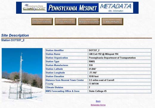 |
| Figure 5. Sample metadata page for an RWIS site. |
PennDOT's Bureau of Maintenance and Operations scheduled three consecutive training sessions for more than 160 roadway weather managers on their staff. Each PennDOT district sent representatives to a central location. At the request of the winter-storm project manager, a four-part training plan was drafted and submitted for PennDOT's approval. This was beta-tested at a local district office, and adjustments were made based on important feedback from PennDOT personnel. In the first and second part, the NWS Warning Coordination Meteorologist (WCM) taught the fundamentals of weather and products available from the NWS WFOs. The State climatologist taught the third and fourth parts that centered on utilizing RWIS data and winter weather forecasting techniques, including a desktop exercise for all participants. The training occurred during the week of October 7, 2002.
A group of roadway weather managers arrived midday for 4 hours of training, followed by a session of the same length the next morning. At midday of the second day, the first group departed and was replaced by another set of roadway weather managers. This process continued through three cycles.
Approximately 1 hour of the course was devoted to essentials of atmospheric circulations. Another hour covered the climatology of winter weather in Pennsylvania. Time was also committed to reviewing the forecast products available from local NWS WFOs. The second half of the training focused on interpreting radar, reading numerical model forecasts, and connecting RWIS observations to local forecasts. Figure 6 illustrates a component of the training sessions from a sample Microsoft® PowerPoint® slide. A month after the initial sessions, another smaller group of managers training session. was also trained, and the WCM spent a day at a District office in western Pennsylvania conducting further training.
 |
| Figure 6. Tabletop exercise from roadway managers |
As mentioned above, researchers intended to use the RWIS to refine mesoscale model initial conditions to improve weather forecasts. However, a large amount of time was spent resolving the uncertainty of the frequency and timing of RWIS observations and other issues related to the variety of data formats required. Researchers also determined that the lack of station history and precise location information was critical. A major effort was expended to provide this documentation, something not initially planned for in the proposal. Additionally, it is debatable whether RWIS data would enhance mesoscale model initial conditions in light of recent sensitivity studies that indicate the need for a denser upper air, rather than surface, network of observations. Therefore, this part of the project was postponed.
As indicated, most of the problems encountered revolved around data transmission and data format issues.
The State Climate Office was responsible for creating the database and its reports, developing quality assurance procedures, visiting the RWIS sites to obtain station metadata, and conducting part of the road managers training.
The NWS wrote some of the programs to capture the RWIS data and helped design the forecast Web page that links to all pertinent NWS WFO zone forecasts within PennDOT. PennDOT amended software so NWS and the State Climate Office could receive RWIS reports, and provided valuable guidance to training session designs and finances for all RWIS managers to attend. They also sought advice on siting two new RWIS sites and sought PSU's assistance in designing the quality assurance for all RWIS sites. They made their field offices available to NWS and the State Climate Office to test receiving 5-minute data.
In retrospect, communication with PennDOT personnel is critical to the success of the collaboration. Awareness of the different infrastructures within PennDOT would be useful for future endeavors, especially in light of the various hierarchies within State agencies. A designated staff member within PennDOT is needed for continuity of the project. It is strongly recommended that all State DOTs move toward wireless technology for their RWIS networks. Future partnerships must also include a comprehensive metadata of the RWIS networks for ready inclusion into the National Oceanic and Atmospheric Administration's (NOAA) plans for a national mesonet and modernization of their cooperative network.
1 AWIPS: An integrated suite of automated data-processing equipment that supports complex analysis, interactive processing, display of hydrometeorological data, and the rapid dissemination of warnings and forecasts in a highly reliable manner.

